Transcription
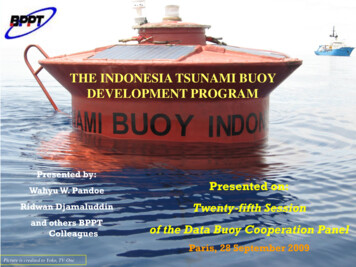
THE INDONESIA TSUNAMI BUOYDEVELOPMENT PROGRAMPresented by:Wahyu W. PandoePresented on:Ridwan DjamaluddinTwenty-fifth Sessionand others BPPTColleaguesof the Data Buoy Cooperation PanelParis, 28 September 2009Picture is credited to Yoko, TV-One
Design ofIndonesian Tsunami Early Warning SystemTelecommunicationSatelliteControl CenterBPPTGPSReceivingStationBuoyTide gaugeGPSOBSPressureGaugeIndian Ocean Plate Jan Sopaheluwakan, 2005Seismograph
Indonesia Tsunami Buoy DevelopmentProgramPriority Program of BPPT2006 – 2008
Executing Units at BPPT andCollaborationsIndonesia AgenciesBTeksulraTPSATISDAPTLTIEMPTIKInternational Collaborations:MEPPONOAA, USAB2TKSTIRBRBPPHGFZ – GermanyB2TEBTMPATSB Malaysia
International Collaborations Germany-Indonesia Tsunami EarlyWarning System (GITEWS) onGITEWS Buoys (9 buoys) NOAA on DART Buoys (3 buoys) ATSB Malaysia on Wave ScanTsunami Buoy (1 buoy)
Current Indonesian Tsunameter StatusTo replace NOAA’ s ETD[June 2008 – Sep 2008]
2006 Buoy & OBU Design (1st generation erAcousticmodemBatteriesCPUCPU ducer17” Floaters
The Indonesian INA-BUOY Tsunameter1st generation–KRAKATAU: Indian Ocean at 6.5S, 104.0E, Southwestof Sunda Strait, 2053m depth (Status: recovered and moved toKomodo, was replaced bwith the 2nd generation for a while, and to bereplaced with DART-ETD by early 2010))–KOMODO: Flores Se, 40nm north of Sumbawa Island(status: recovered after drifting, mooring line was broken due to possiblevandalism)
The Indonesian INA-BUOY Tsunameter2nd Generationdeployment test in “KRAKATAU” site replacingthe 1st Gen Series in Sept 2008Operational in HALMAHERA and ARU/NAIRAsince April 2009Surface buoyBottom Unit / BPR
InaBuoy Engineering Design 2007-2008,2nd Generation First prototype wassuccesfully deployed inIndian Ocean, south ofLampung 2 other units have beendeployed in eastern Indonesiawaters in April-May 2009 3 others are underconstruction at BPPHSurabaya and B2TKSSerpong 3 others are still under finaldesign and early step ofmanufacturing
Design and Manufacture@ BPPT's Facilities
Hydrodynamics & Structural Tests
Deep Sea Mooring
Tsunami Buoy Sea OperationsUS DART BuoyInaBuoyWaveScan BuoyGITEWS Buoy
READ DOWN STATION (RDS) BPPT 1ST BLD, 20TH FLOOR, South Wing Operational 24h continuously 10 operators are divided into 5 groups and 3shifts Two-ways data link to BMKG
Buoy Data Flow in InaTEWS
SISTEM BUOY CONTROL MONITOR
Buoy Position Monitor
Post analysis of12 Sept 2007 Earthquake Location: Indian Ocean, west of Bengkulu,Sumatra Local time: 18.10 WIB Magnitude: 8.4 Depth: 10km (shallow) During the 12 Sept 2007 EQ, ‘Krakatau’was working offline due to unscheduledmaintenance of the surface buoy
Bengkulu Earthquake & Tsunami, 12 September 2007
EQ (andTsunami) on 12 Sept 2007observed by Indonesian Krakatau TsunameterRaw Data 40’LP Filtereddetected Tsunami signals?Predictive Filtering anddetiding algorithms arerequired in real time !
Recorded Vs Predicted Sea Levelfor Krakatau Tsunameter
Bengkulu EQ 12 Sept2007Tsunamisignal TUNAMI (Tohoku University’s Numerical-Analysis for Investigation of Tsunami)Numerical model (blue line) of Tsunami wave height was performed separately. The tsunami source and their parameter are adopted from USGS ParameterSource which their dimension are estimated by Okal Formula giving the size of191x96 Km and maximum slip 5.5 m Well agree between observation and numerical model for the first tsunami peakwave Discrepancies are due to coarse bathymetrical data and assumption defined in theopen boundaries
Simeulue (Sinabang) Earthquake & TsunamiDetected by DART-IO 0N92E #5340120 February 2008, M 7.4
Other Oceanographic AspectsObserved by DART 53401 Tsunameter (0N, 92E)Sea level anomalies recorded in Indian Ocean
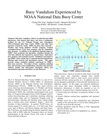
Vandalisms issues: Several cases:- Indonesian KOMODO Buoy: broken mooring line inend Sept 2008, redeployment in Oct 2008, andvandalized again in early Nov 2008 fixed,operational until 7 Sept 2009, and get vandalized again.- German’s buoy mooring line was cut below keel (May2007) fixed- Indonesian ‘Krakatau’ buoy was missing on 31 Dec2007- DART-II 53401 Indian Ocean buoy stops transmissionon 14 March 2008 vandalized all surface buoyinstruments- DART-ETD South of Bali have lost contact since 25September 2008- Intensify socialization to the local/nationalfisheries communities and local authorities
KOMODO Tsunameter (Flores Sea)November 2008Two weekslater
KRAKATAU Tsunameter (IndianOcean, south of Sumatra)BPPT - RI220mNilspin Jacketed Steel Wire, 3/8” ( ½”), 210 m47m
GITEWS Buoy (Indian Ocean, west of Sumatra) Fisherman Net, or Unexpected high seastate, or Broken mooring line
DART-II Standard 0N 92E(Indian Ocean, west of Sumatra)Re-visited on 20 August 2009
ATLAS Buoy:Entangled Tuna fishing gear on amooring line
Preventing VandalismSource: JTIC, 2008
Development Programs Local tsunamidetection system Data utilization
Development ProgramsParallel operation of 2pressure sensors in onetsunameter:one @ BPR sitting atthe bottomthe other one attachedon the mooring lineSecondarypressure gaugePrimarypressure gauge
Baruna Jaya Ship Particulars
Thank you
- Indonesian KOMODO Buoy: broken mooring line in end Sept 2008, redeployment in Oct 2008, and vandalized again in early Nov 2008 fixed, operational until 7 Sept 2009, and get vandalized again. - German's buoy mooring line was cut below keel (May 2007) fixed - Indonesian 'Krakatau' buoy was missing on 31 Dec 2007