Transcription
Part 2The orphan tsunami みなしご 津 波A PACIFIC TSUNAMI flooded Japanese shores in January 1700. Thewaters drove villagers to high ground, damaged salt kilns and fishingshacks, drowned paddies and crops, ascended a castle moat, entered agovernment storehouse, washed away more than dozen buildings, andspread flames that consumed twenty more. Return flows contributed to anautical accident that sank tons of rice and killed two sailors. Samuraimagistrates issued rice to afflicted villagers and requested lumber forthose left homeless. A village headman received no advance warningfrom an earthquake; he wondered what to call the waves (quote,opposite).These glimpses of the 1700 tsunami in Japan survive in olddocuments written by samurai, merchants, and peasants. Severalgenerations of Japanese researchers have combed such documents tolearn about historical earthquakes and tsunamis. In 1943 an earthquakehistorian included two accounts of the flooding of 1700 in an anthologyof old Japanese accounts of earthquakes and related phenomena. By theearly 1990s the event had become Japan’s best-documented tsunami ofunknown origin.Part 2 of this book contains a chapter for each of six main Japanesevillages or towns from which the 1700 tsunami is known. Each chapterbegins with a summary of main points, a geographical and historicalintroduction, and the content of the tsunami account itself. Other parts ofthe chapters explore related human and natural history. Concludingestimates of tsunami height reappear in Part 3 as clues for defininghazards in North America.The orphan tsunami27
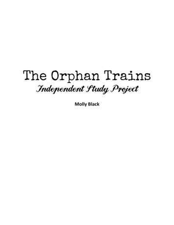
World map, 1708East at top;north to left.eciffo KömöThe RedHaired[Holland]12,500 ri[50,000 km;listed asHolland’sdistancefromJapan]28THE ORPHAN TSUNAMI OF 1700
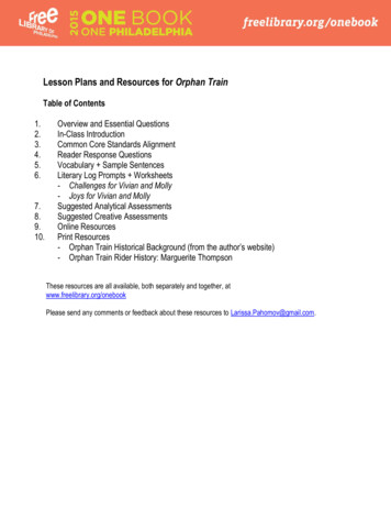
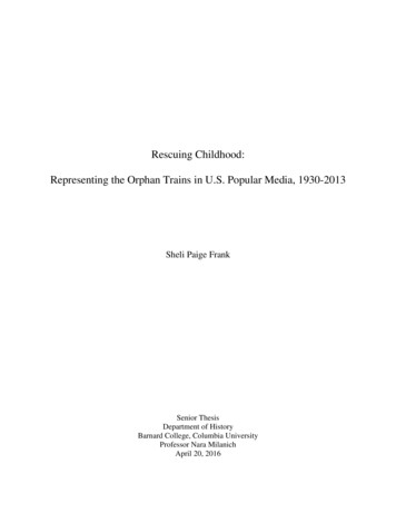
Literate hosts 文字を使える人たちIn Japan, the 1700 tsunami reached a society ready to write about it.THE YEAR 1700, though almost a century earlier than thefirst written records from northwestern North America, comeslate in the written history of Japan. The year belongs,moreover, to an era of Japanese stability, bureaucracy, andliteracy that promoted record-keeping.That era began with national pacification early in the17th century. By 1700, the country had known almost acentury of peace for the first time in 500 years. Many in itsmilitary class were making their livings as bureaucrats.Samurai did paperwork for the Tokugawa shogun, thenational leader in Edo (now Tokyo). They also administeredthe hinterlands as vassals of regional land barons, the daimyo.Reading and writing extended beyond this ruling elite tocommoners urban and rural. Booksellers offered poetry, shortstories, cookbooks, farm manuals, and children's textbooks.Merchants tracked goods and services in an economy drivenby bustling cities. Peasants prepared documents for villagesthey headed.The accounts of the 1700 tsunami accordingly comefrom representatives of three social classes. The writers weremilitary men employed by daimyo domains (p. 44, 70),merchants in business and local goverment (p. 53, 85), andpeasants serving as village officials (p. 70, 77).PERIOD MAPS open windows into the society in whichthose samurai, merchants, and peasants wrote. Such mapshelp introduce each of the six chapters in this part of thebook. As a further introduction to a bygone time and place,consider the career of a commercial mapmaker and two of theproducts he sold: a decorative map of the world (opposite)and a travel map of Japan (overleaf).Ishikawa Tomonobu wrote and drew in the decadesaround 1700. In addition to making maps, he illustratedcalendars and novellas, composed linked-verse poetry andhumorous fiction, and published travel guides and courtesanevaluations. Like many of his contemporaries, including theshort-story writer Ihara Saikaku and the playwrightChikamatsu Monzaemon (p. 63), Ishikawa worked in atradition, ukiyo, or floating world, that focused on daily lifeand its fleeting pleasures.Ishikawa’s world map, descended from 16th-centuryEuropean compilations, was modeled on 17th-centuryON JAPAN under the Tokugawa shoguns, see Totman (1993). Chibbett (1977, p.123) reviews the origins of ukiyo-e, floating-world pictures and paintings.ISHIKAWA TOMONOBU (or Ishikawa Ryüsen) is profiled in a Japanese literaryencyclopedia, Nihon Koten Bungaku Daijiten Henshü I’inkai, (1983, p. 129).ISHIKAWA’S WORLD MAP, “Bankoku sökaizu” (“General world map”), isreproduced courtesy of the East Asian Library, University of California, Berkeley.Unno (1994, p. 404-409) traces its origins to 16th-century Chinese copies ofEuropean maps. Those copies, and Ishikawa’s version as well, retain 16th-centuryEuropean speculation on an enormous southern continent and on the shape ofJapanese surveyors’ certificates. The map served as aninterior decoration hung lengthwise, east to the top. Acompanion sheet contained portraits of the world’s peoples.The map depicts an ocean between the Japanese islandsfrom the Americas. Japanese phonetic symbols identifyAmerica and Peru. Chinese characters for “The Red Haired”denote Holland, Japan’s sole European trading partnerbetween 1639 and 1854.The travel map, “Nihon kaisan chöriku zu,” depictsJapan “sea to mountains.” Ishikawa issued its first edition in1691, woodblock printed and hand colored. The version onthe overleaf dates from 1694.Ishikawa makes “Nihon kaisan” useful to the traveler byfitting his subject into a rectangular format and by fillingmargins with tourist information. Marginal tables give traveldistances, domestic and international. Half the domestic tablegives distances by land; the other half, distances by sea.Additional tables name the most important shrine in eachcounty of each province. The lower left corner of the mapprovides an almanac on solstices, equinoxes, phases of themoon, and tides. Above it, signs of the Chinese zodiac denotetwelve compass directions (p. 43).Frequent travelers in Ishikawa’s Japan included daimyoand their entourages, who journeyed to Edo every year or twofor required attendance upon the shogun. A square or circleon the travel map represents each daimyo domain. Anadjoining label gives a measure of daimyo status—thedomain’s official valuation in terms of rice yield (p. 71)—andthe name of the daimyo himself.The ukiyo artist further depicts cities, castles, highways,fishermen, merchant marines, and urban samurai. Roofsrepresent the urban sprawl of the shogun’s capital, Edo, itspopulation soon to surpass one million. The Tökaidö, orEastern Sea Road, wends its way toward Kyoto, the imperialcapital since A.D. 794. Fifty-three way stations awaittravelers seeking overnight accomodations.Just off the Tökaidö, the pines of Miho beckon from afloating-world island. On a peninsula rendered moreaccurately on page 26, in a village of 300 peasants, a farmeror fisherman will soon write the most vivid and inquisitive ofJapan’s accounts of the orphan tsunami of 1700 (p. 78-79).western North America. The Chinese copies were made under the direction ofMatteo Ricci (1552-1610), a Jesuit missionary. Examples soon reached Japan; by1605, Jesuits in Kyoto were using Ricci maps to teach geography. A Japaneseadaptation of the Ricci model appeared by 1645. In his version, Ishikawa revisedRicci’s Asian geography and stylized other parts of the map. His 12,500-ridistance to Holland, listed also on the tourist map overleaf (p. 30), exceeds Earth’scircumference (40,074 km at the equator) if his ri equals 3.93 km (theconventional conversion; Nelson and Haig, 1997, p. 1268).The orphan tsunami29
Tourist map, 1694International distancesHolland, 12,500 ri (see footnote, p. 29)Ezo (now Hokkaido)was then held mostly byAinu, a native people.Domestic distances by major roads,such as the Tökaidö (right), and by seaNorthLand areadistorted artfullyat rightKyotoDETAIL ABOVEEastCompass(p. 43)EdoN500 esSouthTemples and shrines listed by kuni (ancient province) and gun (county)30THE ORPHAN TSUNAMI OF 1700
Mount FujiProvince boundary(shown more exactly onofficial map, next page).Suruga 駿河 provincecontained seven gun 七郡,or counties.Sumpu castle, site ofearliest known writing of“tsunami” (p. 41)Tökaidö, the “Eastern SeaRoad,” connected imperialKyoto and shogunal Edo.One of 53 way stations.Miho 三保, source of anaccount of the 1700tsunami (p. 76-79)The orphan tsunamiEdo 江戸,the Tokugawa shoguns’capital. Populationapproaching one millionin 1700 (p. 61). BecameTokyo in 1868.“NIHON KAISANCHÖRIKU ZU,” by IshikawaTomonobu (p. 29), 1694edition (Akioka, 1997, p.214), fills a sheet nearly 1.7 mby 1.2 m. Walter (1994, p.194) likens the geographicdistortion to that in a subwaymap. Courtesy of East AsianLibrary, University ofCalifornia, Berkeley. Moreexcerpts, p. 43, 70-72.31
Wetted places 浸水した地域The orphan tsunami flooded sites along nearly 1000 kilometers of Japan’s Pacific amuraNakaminatoKYOTOPACIFIC OCEANEDOMount FujiWakayamaMihoBookworm burrowsTanabe1702Part 2 of this book follows the January 1700 tsunami southwestward alongJapan's Pacific coast from Kuwagasaki to Tanabe.THE TOKUGAWA SHOGUNATE, which ruled Japan from 1603 to 1867, ordered the entire countrymapped five times. The fourth such mapping, in 1697-1702, produced a sheet for each of Japan’s 83ancient provinces at 1:21,600 scale (slightly larger than the standard scale of today’s 7.5-minutetopographic maps in the United States). From these detailed maps the shogunate compiled “GenrokuNihon sözu,” above, a map of all Japan in the Genroku era (Unno, 1994, p. 397, 472).THE MAP DEPICTS the provinces in various earth tones. Bookworms (p. 87) made the burrows thatunfold in symmetrical pairs.FROM THE COLLECTION of Ashida Koreto (1877-1960); “Genroku Nihon sözu” is map 09-110 ofAshida Bunko Hensan I’inkai (2004, p. 154). The entire map, now in two pieces, spans 3.1 by 4.4meters. Courtesy of the library of Meiji University, Tokyo.32THE ORPHAN TSUNAMI OF 1700Area aboveJAPANTsunamipath fromCascadiaEdoN500 km
PLACES FLOODED by the 1700 tsunami in Japan includeKuwagasaki, Tsugaruishi, Ötsuchi, Miho, and Tanabe. Someof the accounts mention damage in additional villages. In oneaccount, the tsunami takes the form of rough seas that initiatea nautical accident near Nakaminato. The writers kaminatoPLACEportvillagecastle townOTHER SITES whereaccount was written orwhere tsunami enteredWRITERS士 samurai農 peasant商 merchantLOSSESbuildingsfields or cropssalt kilnsKuwagasaki p. 36-49Adjoined Miyako,where Morioka-hanhad a district office.Nearly 300 housesThe tsunami accountoriginated in Miyako. It wasdelivered inland to Morioka,where it entered administrative records of Morioka-han.士 Magistrates inMiyako andscribes inMorioka castle13 housesdestroyed byflooding, 20 moreby a concurrentfireTsugaruishi p. 50-57Along a farmed plainand a river known forcrook-nose salmon.Nearly 200 housesThe writer describes lossesalong the nearby bayshoreand mentions, as hearsay,the flooding and fire inKuwagasaki.商 Family thatlaterpurchasedsamuraistatusHousesdestroyed byflooding alongbayshore nearTsugaruishiÖtsuchi p. 58-65Like Miyako,headquarters of anadministrative districtof Morioka-hanThe tsunami accountoriginated in Ötsuchi. Asummary survived there, asdo details in administrativerecords in Morioka. Losseswere said to have beenreported to Edo.士 Magistrates inÖtsuchi andscribes inMorioka castleDamaged:22paddies andfieldsNakaminato p. 66-75Transferred cargobetween seagoingships and river boatsthat plied inlandwaterways to EdoThe account focuses on ashipwreck in rocks offshoreof Isohama village, nearby.The cargo originated inNakamura-han. Officials ofMito-han investigated.農 The boat’s crewand officials ofIsohama village士 Officials ofMito-hanTwo sailors killedand nearly 30tons of rice sunkin an accidentcaused mainly bya stormMiho p. 76-83Picturesque placenear the Tökaidö.Population 300The account remained inMiho, where it was laterincluded in an anthology ofheadmen’s writings.農 VillageheadmanNo damagereportedTanabe p. 84-92Capitol of a sector ofWakayama-han.Population no lessthan 2600Farming or fishingsettlements near Tanabe:Atonoura, Mera,Mikonohama, and Shinjö商 Mayor ofTanabe, alsoserving asdistrict mayorof surroundingvillagesRice paddies andwheat crops lostin Atonoura,Mera,Mikonohama, andShinjö.Governmentstorehouseflooded in ShinjörocksIsohamaMihoTanabethree of their society’s four main classes: the bushi, or samurai; farmers and other peasants; and merchants (p. 53).The main accounts grace the next two pages. We parsethem, from north to south, in the six chapters that follow.-han, daimyo domainCastleShippingrouteRoad with paired dots atintervals of 1 ri (4 km)The orphan tsunami33
Primary sources 根本史料MIHO三保“Miho-murayöji oboe”『三保村用事覚』p. 78-79EACH ACCOUNT BEGINS at its upper right. The columnsread from top to bottom and from right to left (headnote, p.39). The account reappears with transliteration andtranslation on the pages identified in italics below thedocument title.Each title is enclosed by quotation marks (『 』 inJapanese). Most are names shared by other documents;“Zassho,” for instance, means “Miscellaneous records.” Tomake such titles unique we add, outside quotation marks, thename of the family (-ke) or daimyo domain (-han) thatproduced or preserved the atoEdoMihoNTanabe500 km34THE ORPHAN TSUNAMI OF 町大帳』p. 86
�Nikki kakitome �留帳』盛岡藩『雑書』p. 52p. �用留』p. 68-69THE ORPHAN TSUNAMI盛岡藩『雑書』p. 6035
On the scenic spit at Miho, a village leader puzzled over a train of waves in January 1700 (p. 40, 78-79). Part 2 The orphan tsunami 0 0j0W0T lâm% A PACIFIC TSUNAMI flooded Japanese shores in January 1700. The waters drove villagers to high ground, damaged salt kilns and fishing shacks, dro