Transcription
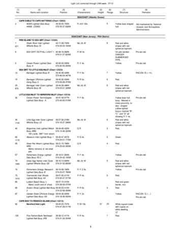
Light List corrected through LNM week: 37/13(1)No.(2)Name and nge(7)Structure(8)RemarksSEACOAST (Atlantic Ocean)3CAPE SABLE TO CAPE HATTERAS (Chart 13003)NOAA Lighted Data Buoy39-35-00.705N44066 (ODAS)072-35-57.636W5Fl (4)Y 20sYellow boat shapedhull.Aid maintained by NationalOceanic and AtmosphericAdministration.SEACOAST (New Jersey) - Fifth DistrictFIRE ISLAND TO SEA GIRT (Chart 12326)Shark River Inlet Lighted40-11-08.700N7Whistle Buoy SI074-00-03.100W871Mo (A) W8SEA GIRT OUTFALL LIGHT 1 40-08-16.960N074-01-27.624WFl W 4sOn pile wordedDANGERSUBMERGEDPIPE.Private aid.9Ocean Power Lighted DataBuoy AFl Y 4sYellow.Private aid.RACON: B (– ).1040-02-00.000N073-40-00.000WSEA GIRT TO LITTLE EGG INLET (Chart 12323)Barnegat Lighted Buoy B39-45-48.429N073-46-04.447W6Red and whitestripes with redspherical topmark.Fl Y 6s7Yellow.15Barnegat Offshore LightedGong Buoy 239-45-30.434N073-59-28.470WFl R 6s6Red.25Barnegat Inlet Outer LightedWhistle Buoy BI39-44-28.486N074-03-51.328WMo (A) W6Red and whitestripes with redspherical topmark.87530LITTLE EGG INLET TO HEREFORD INLET (Chart 12318)Ocean Power Technologies40-01-59.977NLighted Data Buoy A073-40-00.019W351100Little Egg Inlet Outer LightedWhistle Buoy LE39-27-56.219N074-16-27.346WFl Y 6sYellow boat hullbuoy. Moored inclose proximity todisc- shapedyellow lightedbuoys marked "B","C" and "D" allshowing Fl Y 4s.Mo (A) W6Red and whitestripes with redspherical topmark.40Brigantine Inlet Lighted Wreck 39-24-48.422NBuoy WR2074-13-46.504W100 yards, 090 from wreck.QR5Red.60Absecon Inlet Lighted Buoy 1Fl G el Pier Wreck Lighted Buoy 39-21-15.768NWR2074-25-00.300WMarks remains of old steelpier.QR67Fishermans Energy LightedData Buoy FE-C39-18-51.900N074-24-02.100WFl Y 4s70Great Egg Harbor Inlet OuterLighted Whistle Buoy GE39-16-13.800N074-31-55.800WMo (A) W74Fishermens Energy ResearchLighted Data Buoy B39-10-08.160N074-23-57.780WFl Y 2.5s75Townsends Inlet ShoalsLighted Bell Buoy 4A39-07-05.411N074-40-37.577WFl R 4s80Ludlam Beach Buoy LMarks south end of shoal.39-07-15.412N074-38-09.070W85Avalon Shoal Lighted Bell Buoy 39-05-23.412N2074-33-56.559WFl R 6s87Garden State Offshore Energy 39-04-36.000NLighted Data Buoy GS074-18-36.000WFl Y 2s12651410Red and whitestripes with redspherical topmark.Yellow.5Private aid.Red.4Red.Yellow.RACON: G (-- .)Private aid.Fl W 10s100Fl R 4s38-58-12.411N074-31-34.554W5Private aid.Red and greenbands; nun.CAPE MAY TO FENWICK ISLAND (Chart 12214)Hereford Inlet Light39-00-23.757N90074-47-28.017WFive Fathom Bank NortheastLighted Bell Buoy 2FBYellow.Private aid.57124White square towerwith cupola onwhite dwelling.577Red.
Light List corrected through LNM week: 37/13(1)No.(2)Name and nge(7)Structure(8)RemarksSEACOAST (New Jersey) - Fifth DistrictCAPE MAY TO FENWICK ISLAND (Chart 12214)Five Fathom Bank NW Lighted 38-57-28.000N105Gong Buoy 3FB074-42-36.000WFl G 4s5Green.115Five Fathom Bank SouthLighted Buoy 4FB38-49-42.409N074-36-46.570WQR4Red.120Five Fathom Bank LightedBuoy F38-46-49.000N074-34-32.000WFl Y 2.5s7Yellow.125Five Fathom Bank Traffic Lane 38-46-49.000NLighted Buoy FA074-44-14.000WFl Y 4s6Yellow.130Five Fathom Bank Traffic Lane 38-46-51.000NLighted Buoy FB074-55-35.000WFl Y 6s7Yellow.135Cape May Inlet Lighted BellBuoy 2CM38-55-47.005N074-51-20.509WFl R 2.5s5Red.145Sewell Point Buoy AMarks firing range.38-55-48.505N074-51-55.911WYellow can.Mariners are cautioned to keepoutside buoys and give the areaa wide berth.150Sewell Point Buoy CMarks firing range.38-55-35.205N074-52-43.814WYellow can.Mariners are cautioned to keepoutside buoys and give the areaa wide berth.155Cape May Light38-55-58.784N074-57-37.379WFl W 15s160McCrie Shoal Lighted Buoy2MS38-50-29.205N074-50-16.607WFl R 4s143516524White tower, redcupola, two whitedwellings nearby.1655Red.RACON: M (– –).SEACOAST (Delaware) - Fifth DistrictCAPE MAY TO FENWICK ISLAND (Chart 12214)Delaware Lighted Buoy D38-27-18.411N165074-41-46.593WFl Y 6s7Yellow.RACON: K (– –).Fl (4)Y 20s5Yellow disc-shapehull.Aid maintained by NationalOceanic and AtmosphericAdministration.168NOAA Lighted Data Buoy44009 (ODAS)170Delaware Traffic Lane Lighted 38-32-44.774NBuoy DA074-46-55.877WFl Y 2.5s6Yellow.175Delaware Traffic Lane Lighted 38-38-12.404NBuoy DB074-52-10.617WFl Y 4s7Yellow.180Delaware Traffic Lane Lighted 38-43-47.403NBuoy DC074-57-32.629WFl Y 2.5s7Yellow.190Hen and Chickens Shoal38-42-42.761NLighted Gong Buoy 1HC074-58-55.888WOff southeast end of shoal.Fl G 2.5s5Green.Indian River Inlet Lighted Gong 38-36-32.902NBuoy 1075-02-46.447WFl G 0WFENWICK ISLAND TO CHINCOTEAGUE ISLAND (Chart 12211)FENWICK ISLAND LIGHT38-27-06.000N075-03-18.000W83White tower.210Fenwick Shoal Lighted Buoy1FSOn west side of shoal.38-26-47.904N074-57-22.637WFl G 4s6Green.220Great Gull Bank Lighted Buoy 38-16-22.413N4075-00-19.650WFl R 4s5Red.223Ocean Power Lighted DataBuoy EFl Y 6s38-29-42.000N073-13-12.000WPrivate aid.Oc W 13sYellow.Private aid.On skeleton tower.HORN: 1 blast ev 15s (2s bl).HORN isactivated by keying the mic 5timeson VHF-FM 83A (157.175MHz).HORNoperates for 30 minutes.SEACOAST (Maryland) - Fifth DistrictOCEAN CITY INLET TO CAPE HATTERAS (Chart 12200)OCEAN CITY INLET JETTY 38-19-27.042N225LIGHT075-05-05.581W4720Iso W 6s3826
Light List corrected through LNM week: 37/13(1)No.(2)Name and nge(7)Structure(8)RemarksSEACOAST (Maryland) - Fifth DistrictOCEAN CITY INLET TO CAPE HATTERAS (Chart 12200)Ocean City Research Buoy38-20-44.000N235075-01-07.000W4730Ocean City Inlet Lighted BellBuoy 238-19-25.536N075-03-41.138W250Little Gull Bank Buoy LG38-16-51.372N075-04-06.691W240Yellow.Fl R 4s6Aid maintained by U.S. ArmyCorps of Engineers.Red.Green and redbands; can.SEACOAST (Virginia) - Fifth DistrictOCEAN CITY INLET TO CAPE HATTERAS (Chart 12200)Winter Quarter Shoal Buoy 5 37-58-18.440N265075-09-06.673WGreen can.270Winter Quarter Shoal LightedBuoy 637-59-42.437N075-01-22.653WFl R 6s275Assateague Light37-54-40.244N075-21-21.699WFl (2)W 5s1545Red.22Conical tower withred and whitebands.1420.1s fl 1sec.,01.s fl 2.8s ec.285Blackfish Bank Buoy 8A37-50-25.451N075-15-52.695W290Blackfish Bank Lighted GongBuoy 8East of 24 foot spot.37-50-37.451N075-12-05.685W295Turners Lump Buoy 237-48-54.454N075-19-25.706W300Turners Lump Lighted BellBuoy 2TL37-48-55.054N075-22-28.714WFl R 4s4Red.305Wachapreague Inlet LightedWhistle Buoy W37-34-54.078N075-33-36.510WMo (A) W6Red and whitestripes with redspherical topmark.6600Emergency light of reducedintensity when main light isextinguished;visible from seaward only.Red nun.Fl R 2.5s4Red.Red nun.315Parramore Bank Lighted Gong 37-32-03.989NBuoy 10075-25-52.715WFl R 4s5Red.320Quinby Inlet Lighted WhistleBuoy Q37-28-06.494N075-36-04.727WMo (A) W5Red and whitestripes withspherical topmark.Great Machipongo InletLighted Whistle Buoy GM37-23-36.000N075-39-06.000WMo (A) W56800Red and whitestripes with redspherical topmark.335Hog Island Lighted Buoy 1237-17-39.510N075-34-38.707WFl R 2.5s5Red.345Cape Charles Lighted BellBuoy 1437-07-23.521N075-40-58.707WFl R 2.5s5Red.347Surface Gunnery Area 8Lighted Buoy GA37-12-00.000N074-52-00.000WFl Y 4s5Yellow348Surface Gunnery Area 8Lighted Buoy GB37-12-00.000N074-51-39.738WFl Y 6s5Yellow.349Surface Gunnery Area 8Lighted Buoy GC37-12-15.000N074-51-49.089WFl Y 2.5s5Yellow.350Cape Charles Light37-07-22.515N075-54-23.285WFl W 5s18Octagonal,pyramidal skeletontower, upper partblack, lower partwhite.180Operates 24 hours.358Scripps Lighted Data BuoyCDIP 18637-01-23.340N075-48-34.980WFl (5)Y 20sYellow sphere withantenna.Private aid.360Chesapeake Light36-54-16.696N075-42-45.818WFl (2)W 15sBlue tower on whitesquaresuperstructure onfour black piles,CHESAPEAKE onsides.147Emergency light of lowerintensity will be displayed whenmain light is inoperative.RACON: N (– ). HORN: 1 blastev 10s (1s bl). Operatescontinuously.36-54-54.720N075-43-12.300WFl (5)Y 20sYellow sphere withantenna.Located inside Buoy Test Area.6700330362Scripps Lighted Data BuoyCDIP 1471801170.1s fl 2.9s ec.0.1s fl 11.9s ec.319Private aid.
Light List corrected through LNM week: 37/13(1)No.(2)Name and nge(7)Structure(8)RemarksSEACOAST (Virginia) - Fifth DistrictOCEAN CITY INLET TO CAPE HATTERAS (Chart 12200)USN SESEF Lighted Buoy A36-55-01.738N365075-38-13.696W370Cape Henry LightFl Y 2.5s36-55-34.860N076-00-25.934WMo (U) W 20s(R1s1s7ssector)fl 2s ecfl 2s ecfl 7s ec1645Yellow.W 17R 15Octagonalpyramidal tower,upper and lowerhalf of each facealternately blackand white.165Red from 154 to 233 , coversshoals outside Cape Charles andMiddle Ground inside bay.Emergency light of lowerintensity will be displayed whenmain light is extinguished.385North Chesapeake EntranceLighted Bell Buoy NCA36-57-30.000N075-48-12.600WFl Y 2.5s6Yellow.390North Chesapeake EntranceLighted Gong Buoy NCB36-56-57.540N075-50-17.040WFl Y 6s7Yellow.395North Chesapeake EntranceLighted Bell Buoy NCC36-56-24.000N075-52-24.000WFl Y 4s6Yellow.400North Chesapeake EntranceLighted Gong Buoy NCD36-56-24.000N075-53-42.000WFl Y 2.5s7Yellow.403North Chesapeake EntranceLighted Buoy NCE36-56-24.000N075-54-57.000WFl Y 6s7Yellow.405Chesapeake Bay EntranceLighted Whistle Buoy CH36-56-08.329N075-57-26.543WMo (A) W7Red and whitestripes with redspherical topmark.RACON: C (– – ).Mo (A) W6Red and whitestripes with redspherical topmark.RACON: K (– –).410Chesapeake Bay Southern Approach- Lighted Whistle Buoy CB36-48-59.743N075-45-36.013W415- Lighted Buoy 136-49-31.622N075-46-54.872WFl G 2.5s6Green.420- Lighted Buoy 236-49-42.555N075-46-46.421WFl R 2.5s4Red.425- Lighted Buoy 336-50-11.605N075-48-15.094WFl G 4s5Green.430- Lighted Buoy 436-50-22.439N075-48-06.648WFl R 4s6Red.435- Lighted Buoy 536-50-51.468N075-49-35.158WFl G 4s5Green.440- Lighted Buoy 636-51-02.355N075-49-26.712WFl R 4s6Red.445- Lighted Buoy 736-51-31.315N075-50-55.159WFl G 2.5s7Green.450- Lighted Buoy 836-51-42.253N075-50-46.702WFl R 2.5s4Red.455- Lighted Buoy 936-52-11.609N075-52-15.956WQG7Green.460- Lighted Buoy 1036-52-21.616N075-52-05.636WQR4Red.465- Lighted Buoy 1136-53-07.671N075-53-19.215WFl G 2.5s6Green.470- Lighted Buoy 1236-53-16.298N075-53-07.343WFl R 2.5s4Red.475- Lighted Buoy 1336-54-03.213N075-54-21.780WFl G 4s5Green.480- Lighted Buoy 1436-54-11.853N075-54-09.931WFl R 4s4Red.485- Lighted Buoy 1536-54-58.594N075-55-24.288WQG6Green.490- Lighted Buoy 1636-55-07.187N075-55-12.403WQR6Red.Fl Y 4s5Yellow.495OCEAN CITY INLET TO CAPE HATTERAS (Chart 12200)USN SESEF Lighted Buoy B36-55-01.735N075-45-28.713W500Rudee Inlet Lighted WhistleBuoy RI36-49-47.177N075-56-57.037WMo (A) W6Red and whitestripes.501Rudee Inlet Entrance LightedBuoy 136-49-46.993N075-57-43.488WFl G 2.5s4Green.4
Light List corrected through LNM week: 37/13(1)No.(2)Name and nge(7)Structure(8)RemarksSEACOAST (Virginia) - Fifth DistrictOCEAN CITY INLET TO CAPE HATTERAS (Chart 12200)Rudee Inlet Entrance Lighted 36-49-50.517N503Buoy 2075-57-44.475WFl R 2.5s505RUDEE INLET JETTY LIGHT 36-49-49.353N4075-57-59.437WIso R 6s515Dam Neck Disposal AreaLighted Buoy A36-50-02.363N075-53-24.010W530Dam Neck Firing Zone LightedBuoy A5405Red.6TR on skeletontower.Fl Y 2.5s4Yellow.36-49-33.539N075-51-01.726WFl Y 2.5s5Yellow.Dam Neck Firing Zone LightedBuoy B36-43-45.544N075-54-22.733WFl Y 4s5Yellow.545False Cape Lighted Buoy 4A36-35-36.558N075-43-58.701WFl R 2.5s5Red.550NOAA Lighted Data Buoy44014 (ODAS)36-36-40.000N074-50-11.000WFl (4)Y 20s5Yellow disc-shapedhull.23Position changed frequently fordredging.Aid maintained by NationalOceanic and AtmosphericAdministration.SEACOAST (North Carolina) - Fifth DistrictOCEAN CITY INLET TO CAPE HATTERAS (Chart 12200)Currituck Beach Light36-22-36.565N555075-49-46.707WFl W 20s560Currituck Lighted Buoy 636-15-49.391N075-35-37.052W565Bodie Island Lighted Buoy 8567DUCK RESEARCH BUOY AREADuck Lighted Data Buoy 118Red conical tower.163Fl R 4s5Red.35-55-48.628N075-27-34.596WFl R 4s5Red.36-11-21.030N075-44-37.146WFl Y 4sYellow.Aid maintained by U.S. ArmyCorps of Engineers.158567.01Duck Lighted Data Buoy 236-11-15.042N075-44-34.794WFl Y 4sYellow.Aid maintained by U.S. ArmyCorps of Engineers.567.02Duck Lighted Data Buoy 336-11-09.048N075-44-32.364WFl Y 4sYellow.Aid maintained by U.S. ArmyCorps of Engineers.568DUCK RESEARCH PIERLIGHT36-11-01.320N075-44-45.000WFl W 4sOn skeleton tower.Aid maintained by U.S. ArmyCorps of Engineers.569Duck Lighted DirectionalWaverider Buoy36-11-58.440N075-42-59.600WQYYellow.Private aid.569.3Triaxys Lighted DirectionalWave Buoy36-15-30.000N075-35-30.000WQYYellow.Aid maintained by U.S. ArmyCorps of Engineers.570OCEAN CITY INLET TO CAPE HATTERAS (Chart 12200)NAVY AIR COMBAT36-13-36.040N075-14-59.860WMANEUVERING RANGETOWER LIGHT A38Fl Y 2.5s71Aid maintained by U.S.Navy.Fl Y 2.5s71Aid maintained by U.S.Navy.575NAVY AIR COMBATMANEUVERING RANGETOWER LIGHT B36-03-53.800N074-58-58.070W577NC Artifical Fishing ReefBuoy AR13036-00-18.615N075-31-58.613W580NAVY AIR COMBATMANEUVERING RANGETOWER LIGHT C35-57-00.180N075-15-56.900W582NC Artificial Fishing ReefBuoy AR14035-56-45.622N075-31-58.608WYellow.Private aid.582.1NC Artificial Fishing ReefBuoy AR14535-54-01.633N075-23-46.584WYellow.Private aid.585NAVY AIR COMBATMANEUVERING RANGETOWER LIGHT G35-47-11.810N075-05-40.860WYellow.Fl Y 2.5s7171Fl Y 2.5s5Private aid.Aid maintained by U.S.Navy.Aid maintained by U.S.Navy.
Light List corrected through LNM week: 37/13(1)No.(2)Name and nge(7)Structure(8)RemarksSEACOAST (North Carolina) - Fifth DistrictOCEAN CITY INLET TO CAPE HATTERAS (Chart 12200)Bodie Island Light35-49-06.809N590075-33-47.895WFl (2)W 30sOregon Inlet- Approach Lighted WhistleBuoy OI2797035-48-37.210N075-30-37.670WMo (A) W35-46-25.914N075-31-30.012WIso W 6s600- JETTY LIGHT61527995616OCEAN CITY INLET TO CAPE HATTERAS (Chart 12200)UNC-Chapel Hill Lighted Data 35-45-00.000NBuoy P075-19-48.000W15618Conical tower,white and blackbands abovegranite base, blackironwork.166Aid maintained by NationalPark Service.6Red and whitestripes.Position frequently shifted withchanging conditions. Topmarknot installed on this aid.7NB on pile.2.5s fl 2.5s ec2.5s fl 22.5sec28Fl Y 4sYellow.Private aid.Yellow.Private aid.Yellow.Private aid.617NC Artificial Fishing ReefBuoy AR160618UNC -Chapel Hill Lighted Data 35-47-18.540NBuoy H075-06-19.200WFl Y 4s620Wimble Shoals Lighted Buoy 10 35-35-42.676N075-19-22.519WFl R 4s625Cape Hatteras LightFl W 7.5s630Outer Diamond Shoals Buoy 2 35-08-24.645N075-23-22.518WRed nun.632NC Artificial Fishing ReefBuoy AR22035-08-11.632N075-40-31.572WYellow.Private aid.632.1NC Artificial Fishing ReefBuoy AR22535-06-48.633N075-39-08.566WYellow.Private aid.632.2NC Artificial Fishing ReefBuoy AR23035-06-19.629N075-43-20.580WYellow.Private aid.635NOAA Lighted Data Buoy41001 (ODAS)34-35-51.772N072-40-06.905WFl (4)Y 20s5Yellow boat-shapedhull.Aid maintained by NationalOceanic and AtmosphericAdministration.637NOAA Lighted Data Buoy41025 (ODAS)35-00-22.000N075-24-07.000WFl (4)Y 20s5Yellow disc-shapedhull.Aid maintained by NationalOceanic and AtmosphericAdministration.638UNC-Chapel Hill Lighted DataBuoy R34-46-56.520N075-56-30.120WFl Y 4sYellow.Private aid.6Red.Marks remaining structure ofDiamond Shoal Light.10Skeleton tower onblack house.456Red and whitestripes with redspherical topmark.Position frequently shifted withchanging conditions.15White tower.85Aid maintained by NationalPark Service.6Red and whitestripes with redspherical topmark.Position frequently shifted withchanging 920N075-31-43.740WCAPE HATTERAS TO LITTLE RIVER INLET (Chart 11520)Diamond Shoals Lighted Buoy 35-09-05.000N12075-17-33.000WHatteras Inlet Light192QR5Red.24Black and whitespirally bandedtower, red brickbase with granitecorners.200Aid maintained by NationalPark Service.35-11-51.513N075-43-55.991WIso W 6sHatteras Inlet Entrance Lighted 35-09-29.602NWhistle Buoy HI075-45-56.934WMo (A) W28630660Ocracoke Light35-06-32.280N075-59-09.671WFW665Ocracoke Inlet EntranceLighted Whistle Buoy OC35-03-28.437N075-58-17.065WMo (A) W667NC Artificial Fishing ReefBuoy AR25034-57-00.616N075-54-58.615WYellow.Private aid.667.1NC Artificial Fishing ReefBuoy AR25534-55-30.613N075-57-58.625WYellow.Private aid.645286256502889548756
Light List corrected through LNM week: 37/13(1)No.(2)Name and nge(7)Structure(8)RemarksSEACOAST (North Carolina) - Fifth DistrictCAPE HATTERAS TO LITTLE RIVER INLET (Chart 11520)NC Artificial Fishing Reef34-40-00.583N667.2Buoy AR315076-44-58.759WYellow.Private aid.Yellow.Private aid.667.3NC Artificial Fishing ReefBuoy AR32034-39-00.584N076-48-58.770W670Cape Lookout Light34-37-21.889N076-31-28.341W675NC Artificial Fishing ReefBuoy AR34234-36-42.587N077-02-16.805WYellow.Private aid.675.1NC Artificial Fishing ReefBuoy AR34034-34-38.588N076-58-33.795WYellow.Private aid.675.2NC Artificial Fishing ReefBuoy AR33034-33-55.589N076-51-18.774WYellow.Private aid.675.3NC Artificial Fishing ReefBuoy AR28534-33-51.598N076-25-30.702WYellow.Private aid.675.4NC Artificial Fishing ReefBuoy AR34534-32-15.590N076-58-28.793WYellow.Private aid.675.5NC Artificial Fishing ReefBuoy AR35034-29-48.597N077-21-22.853WYellow.Private aid.680Cape Lookout Shoals LightedBuoy 234-29-36.602N076-25-40.701W685Fl W 15s15625Black and whitediagonallycheckered tower.169QR4Red.Cape Lookout Lighted Buoy 14 34-18-06.613N076-23-59.190WFl R 4s6Red.689Cape Lookout Shoals LightedData Buoy A34-20-36.000N076-25-12.000WFl Y 4s690Cape Lookout Shoals LightedBuoy 434-26-56.603N076-28-22.707WFl R 2.5s4Red.695Cape Lookout Shoals LightedBuoy 634-27-16.600N076-33-40.722WFl R 6s4Red.705Cape Lookout Shoals Lighted 34-32-54.583NBuoy 8076-36-09.520WMarks wreck of SENATEURDUHAMEL.QR4Red.710Cape Lookout BreakwaterLighted Buoy 234-37-07.590N076-33-44.527WQR3Red.715Beaufort Inlet DumpingGround Buoy A34-37-57.163N076-42-24.290W720Beaufort Inlet Channel Lighted 34-34-49.079NWhistle Buoy BM076-41-33.240WMo (A) W6Red and whitestripes with redspherical topmark.Bogue Inlet Entrance LightedWhistle Buoy BI34-37-35.879N077-06-07.336WMo (A) W6Red and whitestripes with redspherical topmark.34-36-19.171N077-05-33.602WFl Y 4s6Yellow.291252932873029490740Camp Lejeune Danger Zone- Lighted Buoy AYellow.Yellow nun.745- Lighted Buoy B34-35-22.171N077-01-27.591WFl Y 2.5s6Yellow.750- Lighted Buoy C34-30-01.175N077-02-03.589WFl Y 4s6Yellow.755- Lighted Buoy D34-25-28.183N077-05-34.788WFl Y 6s6Yellow.760- Lighted Buoy E34-22-33.602N077-10-59.897WFl Y 4s6Yellow.765- Lighted Buoy F34-21-54.972N077-17-28.632WFl Y 6s6Yellow.770- Lighted Buoy G34-23-36.185N077-23-34.649WFl Y 2.5s6Yellow.775- Lighted Buoy H34-27-56.981N077-21-07.841WFl Y 4s6Yellow.Mo (A) W6Red and whitestripes with redspherical topmark.CAPE HATTERAS TO LITTLE RIVER INLET (Chart 11520)New River Inlet Lighted Whistle 34-31-02.040NBuoy NR077-19-33.313W79029650Private aid.7RACON: M (– –).
Light List corrected through LNM week: 37/13(1)No.(2)Name and nge(7)Structure(8)RemarksSEACOAST (North Carolina) - Fifth DistrictCAPE HATTERAS TO LITTLE RIVER INLET (Chart 11520)NC Artificial Fishing Reef34-21-18.603N793Buoy AR355077-19-52.850WYellow.Private aid.793.1NC Artificial Fishing ReefBuoy AR36034-20-42.607N077-36-10.900WYellow.Private aid.793.2NC Artificial Fishing ReefBuoy AR30034-19-00.612N076-24-28.692WYellow.Private aid.793.4NC Artificial Fishing ReefBuoy AR36234-15-40.610N077-30-22.884WYellow.Private aid.793.5NC Artificial Fishing ReefBuoy AR36434-14-48.610N077-42-52.922WYellow.Private aid.793.6NC Artificial Fishing ReefBuoy AR36634-13-00.611N077-25-04.867WYellow.Private aid.793.7NC Artificial Fishing ReefBuoy AR37034-10-30.614N077-44-28.926WYellow.Private aid.793.8NC Artificial Fishing ReefBuoy AR36834-09-30.614N077-25-46.869WYellow.Private aid.795New Topsail Inlet LightedWhistle Buoy NT34-20-11.677N077-38-26.749WMo (A) W629970Red and whitestripes with redspherical topmark.80030145Masonboro Inlet LightedWhistle Buoy A34-10-21.902N077-47-52.601WMo (A) W5Red and whitestripes with redspherical topmark.802NOAA Lighted Data Buoy41036 (ODAS)34-12-39.000N076-57-09.000WFl (4)Y 20s5Yellow disc shapedhull.Aid maintained by NationalOceanic and AtmosphericAdministration.803UNCW/CORMP Lighted DataBuoy A34-08-32.990N077-43-08.390WFl Y 4sYellow.Private aid.803.1UNCW/CORMP Lighted DataBuoy B33-59-11.460N077-21-44.100WFl Y 4sYellow.Private aid.803.2UNCW/CORMP Lighted DataBuoy C34-08-27.600N077-43-01.800WFl (5)Y 20sYellow.Private aid.804NC Artificial Fishing ReefBuoy AR37234-06-05.618N077-44-46.927WYellow.Private aid.804.1NC Artificial Fishing ReefBuoy AR37634-03-14.621N077-39-38.911WYellow.Private aid.804.2NC Artificial Fishing ReefBuoy AR37834-02-00.621N077-51-58.943WYellow.Private aid.804.3NC Artificial Fishing ReefBuoy AR38233-58-36.625N077-41-10.915WYellow.Private aid.804.4NC Artificial Fishing ReefBuoy AR38633-57-30.626N077-33-16.891WYellow.Private aid.805Carolina Beach Inlet Entrance 34-04-53.957NLighted Whistle Buoy CB077-51-11.107WMo (A) W30260810Oak Island Light33-53-34.164N078-02-05.731WFl (4)W 10s0.1s0.1s0.1s0.1sflflflfl0.9s0.9s0.9s0.9s1695Red and whitestripes with redspherical topmark.24Cylindrical tower,top third black,middle third white,lower third gray.180Shows reduced intensity between190 and 250 .Yellow.Private aid.ec.ec.ecec.812Oak Island Lighted SensorBuoy A33-53-38.196N078-05-06.558WFl Y 6s815NOAA Lighted Data Buoy41013 (ODAS)33-26-11.000N077-44-35.000WFl (4)Y 20s5Yellow disc-shapedhull.Aid maintained by NationalOceanic and AtmosphericAdministration.817NOAA Lighted Data Buoy41424 (Dart)32-55-41.000N072-28-11.000WFl (4)Y 20s5Red and white.Disc shaped hull.Aid maintained by NationalOceanic and AtmosphericAdministration.819NC Artificial Fishing ReefBuoy AR42533-53-06.626N078-07-22.976WYellow.Private aid.819.1NC Artificial Fishing ReefBuoy AR42033-51-15.628N078-06-28.974WYellow.Private aid.819.2NC Artificial Fishing ReefBuoy AR46033-50-00.624N078-21-59.009WYellow.Private aid.8
Light List corrected through LNM week: 37/13(1)No.(2)Name and nge(7)Structure(8)RemarksSEACOAST (North Carolina) - Fifth DistrictCAPE HATTERAS TO LITTLE RIVER INLET (Chart 11520)NC Artificial Fishing Reef33-50-00.627N819.3078-12-58.988WBuoy AR440Yellow.Private aid.819.4NC Artificial Fishing ReefBuoy AR45533-47-00.627N078-17-58.999WYellow.Private aid.819.5NC Artificial Fishing ReefBuoy AR44533-45-00.630N078-13-58.990WYellow.Private aid.820Frying Pan Shoals- Slough Approach LightedWhistle Buoy SA33-42-36.719N077-51-04.973W6Mo (A) WRed and whitestripes with redspherical topmark.825- Slough Buoy 133-39-06.591N077-52-49.152WGreen can.830- Slough Buoy 233-39-17.922N077-52-59.999WRed nun.835- Lighted Buoy 1633-28-47.065N077-35-04.549WFl R 2.5s5Red.845- Lighted Buoy 4FP33-36-29.705N077-54-55.569WFl R 2.5s4Red.850- Lighted Buoy 6FP33-41-00.000N078-04-00.000WFl R 4s6Red.857CAPE HATTERAS TO LITTLE RIVER INLET (Chart 11520)Bald Head Island Lighted33-50-38.976N078-00-43.494WSensor Buoy AFl Y 4sMarks remains of Frying PanShoals Light tower.Yellow.Private aid.Cape Fear River EntranceLighted Whistle Buoy CF33-46-16.703N078-03-01.567WMo (A) W630316Red and whitestripes with redspherical topmark.RACON: C (– – ). On channelcenterline.86531005Lockwoods Folly Inlet Lighted 33-53-49.892N078-14-06.185WWhistle Buoy LWMo (A) W6Red and whitestripes with redsphericaltopmarks.Position frequently shifted withchanging conditions.867UNC Wilmington Lighted DataBuoy SB33-50-32.580N078-28-39.180WFl Y 4sYellow.Private aid.868Cape Fear Lighted ResearchBuoy A33-43-16.020N078-00-52.800WFl (5)Y 20sYellow.Private aid.870Shallotte Inlet Lighted Whistle 33-52-58.266N078-22-53.870WBuoy SH6Red and whitestripes with redspherical topmark.Position frequently shifted withchanging conditions.6Red and whitestripes with redspherical topmark.86031050Mo (A) WNEW JERSEY - Fifth DistrictFIRE ISLAND TO SEA GIRT (Chart 12326)40-11-08.700NShark River Inlet Lighted871074-00-03.100WWhistle Buoy SI7Mo (A) W872SHARK RIVER INLET SOUTH 40-11-11.359N074-00-26.731WBREAKWATER LIGHT 1Fl G 4s336SG on pile.873SHARK RIVER INLET NORTH 40-11-14.838N074-00-28.968WBREAKWATER LIGHT 2Fl R 4s336TR on skeletontower.6Red and whitestripes with redspherical topmark.SEA GIRT TO LITTLE EGG INLET (Chart 12323)Barnegat InletPositions of buoys frequently shifted with changing conditions.87525- Outer Lighted Whistle BuoyBI39-44-28.486N074-03-51.328WMo (A) W880- North Jetty Danger Buoy B 39-45-37.610N074-05-20.824WMarks submerged jetty.900- Lighted Buoy 139-44-48.681N074-04-36.906W910- Buoy 239-44-53.223N074-04-31.968WRed nun.915- Buoy 339-45-02.021N074-04-57.501WGreen can.920- North Jetty Danger Buoy A 39-45-40.810N074-05-24.518WMarks submerged jetty.White and orange;can.5Fl G 2.5sGreen.White and orange;can.9
Light List corrected through LNM week: 37/13(1)No.(2)Name and nge(7)Structure(8)RemarksNEW JERSEY - Fifth DistrictSEA GIRT TO LITTLE EGG INLET (Chart 12323)Barnegat InletPositions of buoys frequently shifted with changing conditions.4Red.405TR on multi-pilestructure.378SG on skeletontower.Fl G negat Light39-45-51.540N074-06-22.230WFl W 10s960- Lighted Buoy 1239-46-00.508N074-06-11.248WFl R 2.5s4Red.965Barnegat Harbor ChannelLighted Buoy 1439-45-50.040N074-06-33.990WFl R 2.5s4Red.970Barnegat Harbor ChannelJunction Buoy B39-45-41.169N074-06-42.537WGreen and redbands; can.975- Buoy 1639-45-42.194N074-06-48.227WRed nun.980- Buoy 1739-45-42.315N074-06-52.658WGreen can.985- Buoy 18Marks submerged piles.39-45-48.174N074-06-57.061WRed nun.990- Buoy 1939-45-56.976N074-07-04.737WGreen can.995- Buoy 2039-45-59.168N074-07-00.677WRed nun.1000- Buoy 2139-46-12.496N074-07-00.716WGreen can.1005- Buoy 2239-46-11.672N074-06-58.200WRed nun.1010- Buoy 2439-46-31.668N074-06-56.994WRed nun.1015- Buoy 2539-46-25.637N074-06-57.361WGreen can.1020- Lighted Buoy 2639-46-41.956N074-07-02.097W1025- Buoy 2739-46-43.571N074-07-07.644WGreen can.1030- Buoy 27A39-46-56.083N074-07-03.852WGreen can.1035- Buoy 2839-46-57.606N074-07-02.331WRed nun.1040- Buoy 2939-47-08.601N074-07-13.471WGreen can.1045- Buoy 29A39-47-16.426N074-07-31.968WGreen can.1050- Lighted Buoy 3039-47-10.972N074-07-11.673W1055- Buoy 3139-47-20.670N074-07-47.661WGreen can.1060- Buoy 3239-47-25.424N074-07-50.112WRed nun.1061- Buoy 32A39-47-36.390 N074-08-10.740 WRed nun.1065- Buoy 3339-47-38.615N074-08-20.084WGreen can.1066- Buoy 33A39-47-36.000N074-08-29.000WGreen can.925- Lighted Buoy 439-45-06.099N074-04-52.129WFl R 6s942- NORTH BREAKWATERLIGHT 639-45-32.796N074-05-22.632WQR943- SOUTH BREAKWATERLIGHT 739-45-25.616N074-05-35.697WQG950- Lighted Buoy 939-45-37.584N074-05-37.494W955- Lighted Buoy 11958163Fl R 2.5s224Fl R 2.5s410Red over whitebrick tower.163Red.Red.Private aid.Replaced by nun from Nov. 15to May 1.Replaced by nun from Nov. 15to May 1.Replaced by nun from Nov. 15to May 1.
Light List corrected through LNM week: 37/13(1)No.(2)Name and nge(7)Structure(8)RemarksNEW JERSEY - Fifth DistrictSEA GIRT TO LITTLE EGG INLET (Chart 12323)Barnegat InletPositions of buoys frequently shifted with changing conditions.1070- Lighted Buoy 3439-47-39.319N074-08-17.640W3Fl R 2.5sRed.Replaced by nun from Nov. 15to May 1.Oyster Creek ChannelPositions of buoys frequently shifted with changing conditions.1073- Buoy 3539-47-33.032N074-08-32.968WGreen can.1075- Buoy 3639-47-31.260N074-08-54.801WRed nun.1080- Buoy 3739-47-31.656N074-08-43.252WGreen can.1085- Buoy 37A39-47-31.877N074-09-05.854WGreen can.1090- Buoy 3839-47-32.147N074-09-15.670WRed nun.1095- Lighted Buoy 4039-47-30.966N074-09-26.325WQR4Red.Mo (A) W6Red and whitestripes with redspherical topmark.Replaced by nun from Nov. 15to May 1.LITTLE EGG INLET TO HEREFORD INLET (Charts 12318)Little Egg InletPositions of buoys frequently shifted with changing conditions.- Outer Lighted Whistle BuoyLE39-27-56.219N074-16-27.346W1105- Buoy 239-28-12.529N074-16-58.636W1110- Lighted Buoy 339-28-26.340N074-17-13.705W1115- Buoy 439-28-31.654N074-17-13.142WRed nun.1117- Buoy 4A39-28-44.119N074-17-39.239WRed nun.1120- Lighted Buoy 539-28-43.064N074-17-49.001WFl G 4s4Green.Replaced by can from Nov. 15to May 01.1125- Lighted Buoy 639-29-00.582N074-18-07.582WQR3Red.Replaced by nun from Nov. 15to May 1.1129- Buoy 839-29-17.480N074-18-16.788W1131- Lighted Buoy 1039-29-44.303N074-18-33.436W1132- Buoy 1139-29-54.661N074-18-58.221WGreen can.39-31-33.224N074-17-37.114WGreen can.Private aid.110035Marshelder Channel- Buoy 11140Red nun.QG4Green.Replaced by can from Nov. 15to May 01.Red nun.Fl R 2.5s4Red.Replaced by nun from Nov. 15to May 01.1145- Buoy 239-31-32.523N074-19-29.319WRed nun.Private aid.1150- Buoy 2A39-31-57.624N074-17-16.313WRed nun.Private aid.1155- Buoy 339-32-12.424N074-17-22.514WGreen can.Private aid.1160- Buoy 439-32-24.424N074-17-28.514WRed nun.Private aid.1165- Buoy 539-32-30.424N074-17-46.515WGreen can.Private aid.Absecon InletPositions of buoys frequently shifted with changing conditions.117060- Lighted Buoy 139-20-47.457N074-24-01.173W5Fl G 4s11Green.
Light List corrected through LNM week: 37/13(1)No.(2)Name and nge(7)Structure(8)RemarksNEW JERSEY - Fifth DistrictLITTLE EGG INLET TO HEREFORD INLET (Charts 12318)Absecon InletPositions of buoys frequently shifted with changing conditions.1175- Lighted Buoy 239-20-51.387N074-23-49.323WFl R 2.5s5Red.1180- Lighted Buoy 339-21-23.664N074-24-11.984WFl G 2.5s5Green.1185- Lighted Buoy 439-21-29.610N074-24-05.990WFl R 2.5s5Red.1190- Lighted Buoy 539-21-41.090N074-24-17.380WFl G 2.5s5Green.1200Harrahs Marina Buoy
NOAA Lighted Data Buoy 44066 (ODAS) Shark River Inlet Lighted Whistle Buoy SI SEA GIRT OUTFALL LIGHT 1 Ocean Power Lighted Data Buoy A Barnegat Lighted Buoy B Barnegat Offshore Lighted Gong Buoy 2 Barnegat Inlet Outer Lighted Whistle Buoy BI Ocean Power Technologies