Transcription
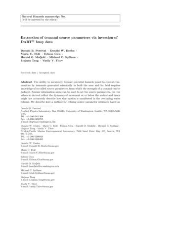
Natural Hazards manuscript No.(will be inserted by the editor)Extraction of tsunami source parameters via inversion ofrDART!buoy dataDonald B. Percival · Donald W. Denbo ·Marie C. Eblé · Edison Gica ·Harold O. Mofjeld · Michael C. Spillane ·Liujuan Tang · Vasily V. TitovReceived: date / Accepted: dateAbstract The ability to accurately forecast potential hazards posed to coastal communities by tsunamis generated seismically in both the near and far field requiresknowledge of so-called source parameters, from which the strength of a tsunami can bededuced. Seismic information alone can be used to set the source parameters, but thevalues so derived reflect the dynamics of movement at or below the seabed and hencemight not accurately describe how this motion is manifested in the overlaying watercolumn. We describe here a method for refining source parameter estimates based onDonald B. PercivalApplied Physics Laboratory, Box 355640, University of Washington, Seattle, WA 98195-5640USATel.: 1-206-5431368Fax: 1-206-5436785E-mail: dbp@apl.washington.eduDonald W. Denbo · Marie C. Eblé · Edison Gica · Harold O. Mofjeld · Michael C. Spillane ·Liujuan Tang · Vasily V. TitovNOAA/Pacific Marine Environmental Laboratory, 7600 Sand Point Way NE, Seattle, WA98115 USATel.: 1-206-5266824Fax: 1-206-5266485Donald W. DenboE-mail: Donald.W.Denbo@noaa.govMarie C. EbléE-mail: Marie.C.Eble@noaa.govEdison GicaE-mail: Edison.Gica@noaa.govHarold O. MofjeldE-mail: hmofjeld@u.washington.eduMichael C. SpillaneE-mail: Mick.Spillane@noaa.govLiujuan TangE-mail: Liujuan.Tang@noaa.govVasily V. TitovE-mail: Vasily.Titov@noaa.gov
2seismic information by making use of data from Deep-ocean Assessment and Reportingrof Tsunamis (DART!) buoys. The method involves using this data to adjust precomputed models via an inversion algorithm so that residuals between the adjusted modelsrand the DART!data are as small as possible in a least squares sense. The inversionalgorithm is statistically based and hence has the ability to assess uncertainty in theestimated source parameters. We describe this inversion algorithm in detail and applyit to the November 2006 Kurl Islands event as a case study.rKeywords Tsunami forecasting · Tsunami source estimation · DART!datainversion · 2006 Kuril Islands tsunami1 IntroductionTsunamis have been recognized as a potential hazard to United States coastal communities since the mid-twentieth century when multiple destructive tsunamis caused damage to the states of Hawaii, Alaska, California, Oregon, and Washington. The NationalOceanic and Atmospheric Administration (NOAA) responded to these disasters withthe establishment of two Tsunami Warning Centers responsible for providing warningsto the United States and her territories. In addition, the agency assumed the leadershiprole in the area of tsunami observations and research and has been measuring tsunamisin the deep ocean for many decades. The scale of destruction and unprecedented loss oflife following the December 2004 Sumatra tsunami prompted a strengthening of effortsto address the threats posed by tsunamis, and, on 20 December 2006, the United StatesCongress passed the “Tsunami Warning and Education Act.” Central to the goal ofprotecting United States coastlines is a “tsunami forecasting capability based on models and measurements, including tsunami inundation models and maps . . . .” To meetthis congressionally mandated forecasting capability, the NOAA Center for TsunamiResearch has developed the Short-term Inundation Forecast for Tsunamis (SIFT) application (Gica et al. 2009; Titov 2009). This application is designed to rapidly andefficiently forecast tsunami heights at specific coastal communities.At each community, estimates of tsunami wave arrival time and amplitude are provided by combining real-time tsunami event data with numerical models. Several keycomponents are integrated within SIFT: deep-ocean observations of tsunamis collectedin real-time, a basin-wide pre-computed propagation database of water level and flowvelocities based on potential seismic unit sources, an inversion algorithm to estimateparameters associated with unit sources based upon the deep-ocean observations, andhigh-resolution tsunami forecast models developed for specific at-risk coastal communities. As a tsunami wave propagates across the open ocean, Deep-ocean Assessmentrand Reporting of Tsunamis (DART!) buoys observe the passage of the wave and relaydata related to its arrival time and amplitude in real or near-real time for use withSIFT. The SIFT application uses the reported observations to refine an initial assessment of the magnitude of the tsunami that is based purely on seismic information. Therrefinement is done by comparing observations from the DART!buoys to models inthe pre-computed propagation database via an inversion algorithm.rIn this article we focus on the inversion algorithm that combines data from DART!buoys with precomputed models, yielding refined estimates of the source parameters.We begin with an overview of the SIFT application (Section 2), after which we describerthe data collected by the DART!buoys (Section 3). We then discuss the precomputed
3rmodels for the DART!data in Section 4 in preparation for a detailed description ofthe inversion algorithm in Section 5, which also includes an illustration of the use ofthe algorithm on the 15 November 2006 Kuril Islands event. The inversion algorithmis based upon a statistical model, and hence we are able to assess the uncertainty inthe resulting source parameter estimates. In Section 6 we use the parameter estimatesand their associated uncertainties to compare the strength of the tsunami as assessedby source parameters set using seismic information and by those estimated using theinversion algorithm. We conclude the main body of the paper with a discussion ofpotential extensions and refinements to the SIFT application in Section 7 and withour conclusions in Section 8 (Appendix A gives some technical details on assessing theuncertainty in the estimated source parameters).2 Short-term Inundation Forecast for Tsunamis (SIFT)The SIFT application exploits the fact that the ocean acts as a low-pass filter, allowinglong-period phenomenon such as tsunamis to be detected by measurement of pressureat a fixed point on the seafloor (Meinig et al. 2005). The strategy behind SIFT is toassess the potential effect of a tsunami by combining pressure measurements collectedin real time with models, thus refining an initial assessment based purely on seismicdata available soon after an earthquake. SIFT is an operational system that mustprovide its assessments in a timely manner. Given that computations concerning wavegeneration, propagation, and inundation must be done under time constraints, SIFTmakes use of a pre-computed propagation database containing water elevations andflow velocities that are generated by standardized earthquakes located within “unitsources,” which are strategically placed along ocean basin subduction zones (Gica etal. 2010). Within SIFT, model time series are extracted from the numerical solution tothe propagation of tsunami waves throughout the ocean basin as generated at the unitsources. Dynamics of these tsunami waves in the open ocean allow them to be linearlycombined to mimic observed data.An inversion algorithm is used to extract source parameters that adjust the amplitudes of the pre-computed models from each unit source using deep-ocean measurerments collected by DART!buoys. These parameters, once determined by the inversionalgorithm, provide the boundary conditions under which previously developed inundation models are run to provide forecasts of incoming tsunami waves at threatenedcoastal communities. These models are run independent of one another in real-timewhile a tsunami is propagating across the open ocean. The models provide an estimateof wave arrival time, wave height, and inundation following tsunami generation. Eachinundation model has been designed and tested against historical events to performunder very stringent time constraints, given that time is generally the single limiting factor in saving lives and property. A total of seventy-five community inundationmodels are scheduled for completion at the end of federal fiscal year 2012.r3 Bottom pressure measurements from DART!buoysrA DART!buoy actually consists of two separate units, namely, a surface buoy anda bottom unit with a pressure recorder. These units communicate with each other viaacoustic telemetry, and the surface buoy in turn communicates with the outside world
4via transmissions to a satellite. The bottom pressure recorder internally measures waterpressure integrated over nonoverlapping 15-sec time windows, so there are 60 4 240 measurements every hour. We associate each window with an integer-valued timeindex n. For simplicity we adopt the convention that n 0 corresponds to the 15sec time window during which a particular tsunami-generating earthquake of interestcommenced. The actual time associated with the nth time window is tn a n (in.hours), where a is a fixed offset, and 1/240 0.004167 hours. In what follows, it isconvenient to set a 0 so that tn is the elapsed time from the 15-sec window containingthe earthquake event. We denote the internal measurements by xn , where n 0 (orn 0) is the index for a measurement recorded before (or after) the earthquake.The internally recorded xn measurements only become fully available when thebottom unit is lifted to the surface for servicing (about once every two years). Normallythe buoy operates in a monitoring mode in which the bottom unit packages togetherone measurement every 15 minutes (a 60 fold reduction in data) over a 6-hour blockfor transmission up to the surface buoy once every 6 hours. We refer to measurementsfrom this monitoring mode as the “15-min stream.” Let nl , l 1, 2, . . ., representthe indices associated with the portion of the 15-min stream that occurs just prior tothe n 0 measurement (the measurement x0 itself might or might not be available).Typically we have nl nl 1 60, but this need not be true for all l due to datadrop-outs. Also note that n 1 itself need not be a multiple of 60 since the earthquakecan occur anywhere within the 15-min reporting cycle.The bottom unit switches out of monitoring mode into a rapid reporting modereither automatically if a seismic event is detected by a DART!buoy or when forcedto do so by an operator at a tsunami warning center sending a signal via satelliteto the surface buoy, which then sends an initiating signal to the bottom unit. Whenin rapid reporting mode, the bottom unit transmits to the surface buoy either a fullreporting of the 15-sec data (the “15-sec stream”) or a reporting of 1-min averages,i.e., the average of four consecutive xn values (the “1-min stream”). The index for a1-min average is the index associated with the most recent 15-sec time window used informing the average:x̄nl 31Xxnl k .4k 0Let nl , l 0, 1, . . ., represent the indices associated with the data that are availableafter (and possibly including) the n 0 measurement. Ignoring the occurrence of dropouts, we have nl nl 1 1 when dealing with just the 15-sec stream; by contrast,if both x̄nl 1 and x̄nl are from the 1-min stream, then nl nl 1 4. Currently theinversion algorithm uses the 1-min stream primarily, but it can make use of additionalmeasurements from the 15-sec or 15-min streams when available and as needed.Figure 1 shows an example of the 15-min and 1-min data streams as recorded byrDART!buoy 21414 before and after the 15 November 2006 Kuril Islands earthquake.Note that there is a gap between the two streams. This gap is due to drop-outs in the 15min stream, which disappeared temporarily more than an hour before the earthquakeand did not reappear again until more than 12 hours later (well after the tsunami hadpassed by this buoy). Even if portions of the 15-min stream had not been lost, the dataavailable for use with the inversion algorithm during the critical time period followingthe earthquake might well have been limited to what is shown in the figure due tothe fact that the 15-min stream is transmitted in 6-hour blocks once every 6 hours.Thus, assuming that the last value shown in the figure for the 15-min stream was in a
5m 5311.50.60.40.20.0 20 15 10 50hours from earthquaker buoy 21414 recorded before and after 15 November 2006 KurilFig. 1 Data from DART!Islands earthquake. The black dots show the 15-min stream, while the black curve is the 1-minstream. Time is in hours from the earthquake (a negative/positive time is before/after theearthquake).6-hour block transmitted soon after it was recorded, the portion of the 15-min streamthat would have filled in the gap would not have been scheduled for transmission untilalmost 5 hours after the earthquake.The data in Fig. 1 have a prominent tidal component that must be removed priorto use of the inversion algorithm described in Section 5. Detiding must be done nearlyin real time and is not a simple matter. We have explored approaches based on harmonic models, Kalman filtering/smoothing, empirical orthogonal functions and loworder polynomial fits (Percival et al. 2010). In what follows, we assume that data xnfrom the 15-sec or 15-min streams or data x̄n from the 1-min stream have been suitably detided. We denote the detided data by dn and d n . (We detided the data using aKalman filter/smoother in all the examples presented below.)r4 Models for DART!buoy dataThe purpose of the inversion algorithm is to use models to estimate the tsunami sourcerstrength and associated confidence limits from observed DART!data. Formulation ofthese models is discussed in detail in Titov et al. (1999) and Gica et al. (2008), fromwhich the following overview is extracted. Seventeen tsunami source regions are defined along portions of the Pacific and Indian Oceans from which earthquake-generatedtsunamis are likely to occur (there are also source regions defined for the Atlantic Oceanand Caribbean Sea). Each source region is divided up into a number of “unit sources.”For example, the Aleutian-Alaska-Canada-Cascadia source region consists of 130 unitsources, each of which has an area of 100 50 km2 (see Fig. 3 below). A database hasbeen constructed containing precomputed adjustable models that predict what wouldrbe observed at a given DART!buoy from the beginning of an earthquake event andonwards. This prediction is based under the assumption that the earthquake was located in a particular unit source and was of moment magnitude MW 7.5 from areverse thrust of appropriate strike, dip and depth (this corresponds to a coseismic slipof 1 m along the fault in the down-dip direction with a rigidity of 4.0 1011 dynes/cm2 ;Section 5.2 has more details about the unit sources). The fault movement is assumedto be instantaneous and results in a vertical ground displacement, as computed by the
6elastic model of Gusiakov (1978) and Okada (1985), that generates the tsunami forthe unit source. The database thus has a precomputed model for each pairing of aparticular buoy and particular unit source.Each adjustable model was constructed with a 15-sec time step, but, to save space inthe database, was subsampled down to a discrete grid of times with a 1-min spacing.In general, the times used in a precomputed model might or might not correspondrto the times at which the DART!buoy data were actually collected relative to thestart of the earthquake. To facilitate matching the observed data with an adjustablemodel, we use cubic splines to interpolate the model. Let g(t) represent the splinerinterpolated model at an arbitrary time t for a particular unit source and DART!buoy. The adjustable model value corresponding to a measurement xnl from that buoyover a 15-sec time window associated with the elapsed time tnl is just g(tnl ). A 1-minaverage x̄nl consists of an average of xnl 3 , xnl 2 , xnl 1 and xnl , so its associatedadjustable model is an average of g(tnl 3 ), g(tnl 2 ), g(tnl 1 ) and g(tnl ).m0.010.00o oo o o o ooooo o oooooo o ooo oo o o o ooo oo o 0.012.002.252.50hours from earthquaker buoy 21414 from an earthquake presumed to haveFig. 2 Adjustable model for DART!originated in unit source a12 in the Kamchatka–Kuril–Japan source region. The black dotsindicate the model values stored in the database at 1-min intervals. The black curve is a cubicspline interpolation of the model outside of the values in the database. The circles show thespline-interpolated values at the times associated with the 1-min stream transmitted from thebuoy during the 15 November 2006 Kuril Islands tsunami event. Time is in hours since theearthquake.Figure 2 shows an example of a spline-interpolated adjustable model g(t) (blackcurve), which is based upom values precomputed at 1-min intervals and stored in therdatabase (black dots). This model is for DART!buoy 21414 for an earthquake originating from unit source a12, which is in the Kamchatka–Kuril–Japan source region(see Fig. 3 below). During the 15 November 2006 Kuril Islands event, this buoy transmitted a 1-min stream x̄nl at times tnl . These times did not coincide exactly withthose of the precomputed model. The circles in the plot show the spline-interpolatedvalues g(tnl ) versus tnl , each of which would be the adjustable prediction for a single(unavailable) 15-sec average xnl (the corresponding prediction for the available x̄nlwould be the average of g(tnl ) and three values associated with times occurring 15, 30and 45 seconds earlier). As the example shows, the cubic spline interpolation providesraccurate estimates of the model values at the times of the DART!observations.
75 Inversion algorithm for extracting source parametersrThe purpose of the inversion algorithm is to use data collected by DART!buoys(after appropriate detiding) to estimate how large an earthquake-generated tsunami is.As noted in the previous section, the inversion algorithm depends upon a database ofprecomputed models. There is a model in the database for every pairing of a particularunit source with a particular buoy. This model predicts what would be observed atthe buoy if an earthquake with a moment magnitude MW 7.5 were to originatefrom a selected unit source. The inversion algorithm adjusts the precomputed modelto account for the fact that an actual earthquake rarely has a magnitude exactly equalto 7.5. The adjustment takes the form of a multiplicative factor, which we denote byα and refer to as the source parameter. A value for the parameter α that is greaterthan unity means that the earthquake has a magnitude greater than 7.5; conversely, avalue less than unity indicates an earthquake with a magnitude less than the standardone. The inversion algorithm estimates α by matching the precomputed model andthe detided data from the buoy via a least squares procedure. As discussed below, thealgorithm takes into account the possibilities that the earthquake might be attributableto more than just a single unit source (so that the adjustments take the form of avector α of multiplicative factors) and that more than one buoy might have collecteddata relevant to a particular event. In Section 5.1 we present the inversion algorithmunder the simplifying assumptions that we know (1) the unit sources associated withthe earthquake and (2) the portions of the detided buoy data that are relevant forassessing the tsunami event (we pay particular attention to assessing the effect ofsampling variability on our estimates of α). Proper selection of the unit sources andof the relevant data is vital for getting good results from the inversion algorithm. Wediscuss source selection in Section 5.2 and data selection in 5.3. (For earlier relatedwork on inversion algorithms, see Johnson et al. (1996) and Wei et al. (2003).)5.1 Estimation of α and assessment of sampling variabilitySuppose that we have selected one or more unit sources to explain the tsunami eventralong with relevant subsets of the detided DART!data. Let J 1 represent thenumber of buoys whose data are to be used in the inversion algorithm, and let K 1be the number of unit sources. Let dj be a column vector of length Nj that containsthe detided data from the jth buoy, where j 1, . . . , J (this can consist of an arbitrarymixture of data from the 15-min, 1-min and 15-sec streams). Let gj,k , k 1, . . . , K, bea vector of length Nj containing the adjustable model that predicts how the tsunamifrom a moment magnitude MW 7.5 earthquake from the kth unit source would berecorded at the jth buoy. The overall model for the data from the jth buoy is takento be a linear combination of the models associated with the K unit sources; i.e., wewritedj α1 gj,1 · · · αK gj,K ej ,where αk is the source parameter for the kth unit source, and ej is a vector of Njerror terms that accounts for the mismatch between the idealized overall model andthe observed data. We can rewrite the above asdj Gj α ej ,(1)
8where Gj is an Nj K matrix whose kth column is gj,k , while α is a column vectorof length K containing α1 , . . . , αK . The models for the data from the individual buoyscan be stacked together to form a model for the data from all the buoys, namely,d Gα e, §T(2)Twhere d dTis a column vector of length N N1 · · · NJ formed by1 , . . . , dJstacking the individual dj on top of one another (here and elsewhere, the superscript §TT“T ” denotes the transpose of a vector or a matrix); G GTis an N 1 , . . . , GJK matrix formed in a similar manner by stacking the Gj together; and e is an N dimensional column vector of errors whose nth element is en .While the data d and their models G are known, the K source parameters in α arenot, so we need some way of determining them. Typically the amount of data N fromall the buoys is much greater than the number of unit sources K. Since there are moreequations N in (2) than unknowns K, we must resort to some additional criterion tofind an appropriate α. One reasonable – and time-honored – criterion is to find thevector such that the sum of squares of the error terms is as small as possible; i.e., wewant α to be such thatkek2 kd Gαk2 is minimized,(3)where kek is the Euclidean norm of the vector e:kek2 NXe2n .n 1This least squares estimator, say α̂, is the solution to the so-called normal equations:GT Gα GT d.(4)There are K equations and K unknowns in the above, so we can determine a uniqueestimator α̂ for α as long as GT G can be inverted. Although GT G is typically invertible,there is no guarantee that it is such, and numerical problems might prevent a routinethat banks upon invertibility from coming up with a stable solution. Because of theseconsiderations, we solve (4) using a singular value decomposition, which, when GT Gis invertible, yields a numerically stable α̂ and, when GT G has a rank lower than K,leads to a solution corresponding to the application of the so-called Moore–Penrosegeneralized inverse.A potential complication with the solution to (4) is that the estimated α̂k in α̂might be a mixture of positive and negative values. This introduces the possibility thatprominent random fluctuations in the data that cannot be handled by a model froma single unit source are being matched by a combination of models with α̂k ’s thatessentially cancel one another out, even though each α̂k might be large. A mixture ofpositive and negative values for α̂k is difficult to reconcile with the physics of earthquakegeneration. To prevent such a mixture, we can alter the least squares criterion suchthat we seek α such thatkek2 kd Gαk2 is minimized subject to the constraints α 0,(5)i.e., αk 0 for k 1, . . . , K. This minimization problem is a special case of Problem 10.1.1 of Fletcher (1987), and the method we use to solve it is a variation of
9Algorithm 10.3.4 in that same reference. Nonnegativity constraints are appropriate forthe great majority of tsunamigenic earthquakes in subduction zones, which are the primary source of major trans-ocean tsunamis; however, exceptions do occur, as discussedin Section 7.The constrained least squares procedure can result in some α̂k being set to zero,which in effect removes the corresponding unit sources from our model for the data. Ifwe were to entertain a reduced model made up of just the unit sources in our originalmodel for which α̂k 0, the unconstrained least squares estimate for each unit sourcein the reduced model will be identical to the corresponding constrained least squaresestimate in the original model. Accordingly, if need be, we redefine G by eliminatingany unit sources for which α̂k 0 originally, and redefine K to be the number ofremaining unit sources. The end result of the constrained least squares procedure isthus a model that can be fit using unconstrained least squares. The correspondingfitted model isd Gα̂ r,(6)where α̂ 0, and r contains the residuals, i.e., the observed errors r d Gα̂.Conditional upon the selected model, these residuals can be examined to assess thesampling variability in the estimates α̂ using statistical theory, the details of whichare given in Appendix A. Since α is of length K, this assessment takes the form of aK K covariance matrix Σ for α̂. The kth diagonal element of Σ gives us the varianceof α̂k , while the (k, l)th off-diagonal element is the covariance between α̂k and α̂l .As an example, we consider the Kuril Islands event of 15 November 2006 (seeHorrollo et al., 2008, and Kowalik et al., 2008, for additional analyses of this event).Portions of the data received from J 11 buoys during the event are shown (afterdetiding) as gray circles in the bottom panel of Fig. 3. The locations of the buoys areshown in the upper panel. The displayed data for four of the buoys (21414, 46413,46408 and 46402) were fit to a model involving K 3 unit sources (denoted as a12,a13 and a14 – the rectangles representing their locations are shaded in dark gray in theinsert in the upper panel). The curves in the bottom panel depict the fitted models atall eleven buoys. The fitted models and data are in reasonably good agreement, whichdemonstrates the efficacy of the procedure in modeling this event over a rather largegeographic area. The estimated source parameters and their covariance matrix are 5.880.188 0.137 0.165.α̂ 4.23 and Σ 0.137 0.253 0.256 .2.290.165 0.256 0.597(7)The square roots of the diagonal elements of Σ give the standard errors of the corresponding elements of α̂. We can form approximate 95% confidence intervals (CIs) forthe unknown source parameters α by multipling the standard errors by 1.96 and thenadding and subtracting the resulting products from the estimates α̂. This procedureyields 95% CIs of [5.03, 6.73] for α1 (source a12), [3.25, 5.22] for α2 (a13) and [0.78, 3.81]for α3 (a14). Note that none of these CIs traps zero. Had the kth such interval doneso, we would be unable to reject the null hypothesis that the unknown αk is equal tozero at the 5% level of significance. Since the CIs indicate that none of the unknownαk ’s are likely to be zero, we can deem all three source parameters to be significantlydifferent from zero with level of significance of 0.05.rThe results shown in Fig. 3 are based upon using data from the first four DART!buoys to observe the Kuril Islands event. Figure 4 shows the effect on the estimated
10Fig. 3 Locations (upper panel) of six unit sources (a12, a13, a14, b13, z13 and y13) in ther buoys (21414, 46413, . . . ,Kamchatka–Kuril–Japan (KKJ) source region and eleven DART!46412), along with detided data from these buoys (gray circles, lower panel) and fitted models(solid curves) for the Kuril Islands event of 15 November 2006. The fitted models are basedupon unit sources a12, a13 and a14 and data from four buoys (21414, 46413, 46408 and 46402).The unit sources b13, a13, z13 and y13 were selected using seismic information only, while a12,a13 and a14 were selected through a trial-and-error process involving an examination of sumsof squares of residuals for various combinations of unit sources. Because the data for buoys46419 and 46405 arrived at approximately the same time, the data and models for these havebeen displaced displaced 5 cm upwards (for 46419) and downwards (for 46405). (Althoughr buoys werethe earthquake emanated from the KKJ source region, ten of the eleven DART!positioned close to the Aleutian–Alaska–Canada–Cascadia source region. Additional buoyshave been deployed since 2006, some now close to the KKJ source region. The reader can goto http://www.ndbc.noaa.gov/dart.shtml to see where buoys are currently deployed.)source parameters caused by using a differing number of buoys. We start by using datafrom the first buoy to see the tsunami event (21414) and then add in one buoy at atime in the order dictated by the arrival times of the tsunami event. The estimated αkare fairly stable across time, with the width of the 95% CIs decreasing markedly uponaddition of the next two buoys (46413 and 46408) and then gradually after that, upuntil the addition of the last four buoys (46419, 46405, 46411 and 46412). The fact thatthe CIs increase upon adding these final buoys can be traced to a misalignment in timebetween the models and observed data, as is evident in the bottom panel of Fig. 3. Fora variety of reasons (including inadequate bottom depth (bathymetry) information,assumed wave dynamics, limited spatial resolution in the model and issues related tofinite difference approximations to the equations of motion), any mismatch in propagation time between actual and modeled tsunamis will tend to increase with distancerfrom the unit source. The recent deployment of addition DART!buoys ensures that
118alphas6ooooooooooo1011420123456789number of buoysFig. 4 Estimated source parameters α̂ and associated 95% confidence interval
to the surface buoy, which then sends an initiating signal to the bottom unit. When in rapid reporting mode, the bottom unit transmits to the surface buoy either a full reporting of the 15-sec data (the "15-sec stream") or a reporting of 1-min averages, i.e., the average of four consecutive xn values (the "1-min stream"). The index for a