Transcription
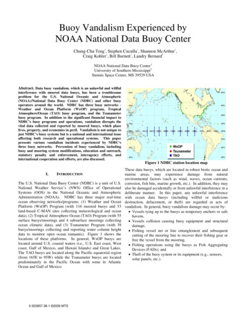
Buoy Vandalism Experienced byNOAA National Data Buoy Center111Chung-Chu Teng , Stephen Cucullu , Shannon McArthur ,112Craig Kohler , Bill Burnett , Landry BernardNOAA National Data Buoy Center1University of Southern Mississippi2Stennis Space Center, MS 39529 USAAbstract. Data buoy vandalism, which is an unlawful and willfulinterference with moored data buoys, has been a troublesomeproblem for the U.S. National Oceanic and Atmospheric(NOAA)/National Data Buoy Center (NDBC) and other buoyoperators around the world. NDBC has three buoy networks Weather and Ocean Platform (WxOP) program, TropicalAtmosphere/Ocean (TAO) buoy program, and the Tsunameterbuoy program. In addition to the significant financial impact toNDBC’s buoy programs and operations, vandalism disrupts thevital data collected and reported by moored buoys, which placelives, property, and economies in peril. Vandalism is not unique tojust NDBC’s buoy systems but is a national and international issueaffecting both research and operational systems. This paperpresents various vandalism incidents experienced by NDBC‘sthree buoy networks. Prevention of buoy vandalism, includingbuoy and mooring system modifications, education and outreach,statutory penalty and enforcement, interagency efforts, andinternational cooperation and efforts, are also discussed.Figure 1 NDBC station location mapI.INTRODUCTIONThe U.S. National Data Buoy Center (NDBC) is a unit of U.S.National Weather Service’s (NWS) Office of OperationalSystems (OOS) in the National Oceanic and AtmosphericAdministration (NOAA). NDBC has three major real-timeocean observing networks/programs: (1) Weather and OceanPlatform (WxOP) Program (with 116 moored buoys and 53land-based C-MAN sites collecting meteorological and oceandata), (2) Tropical Atmosphere Ocean (TAO) Program (with 55surface buoys/moorings and 4 subsurface moorings collectingocean climatic data), and (3) Tsunameter Program (with 39buoys/moorings collecting and reporting water column heightdata to monitor open ocean tsunamis). Figure 1 shows thelocations of these platforms. In general, WxOP buoys arelocated around U.S. coastal waters (i.e., U.S. East coast, Westcoast, Gulf of Mexico, and Hawaii Islands) and Great Lakes.The TAO buoys are located along the Pacific equatorial region(from 165E to 95W) while the Tsunameter buoys are locatedpredominately in the Pacific Ocean with some in AtlanticOcean and Gulf of Mexico.0-933957-38-1 2009 MTSThese data buoys, which are located in robust biotic ocean andmarine areas, may experience damage from naturalenvironmental factors (such as wind, waves, ocean currents,corrosion, fish bite, marine growth, etc.). In addition, they mayalso be damaged accidentally or from unlawful interference in adeliberate manner. In this paper, any unlawful interferencewith ocean data buoys (including willful or maliciousdestruction, defacement, or theft) are regarded as acts ofvandalism. In general, buoy vandalism damage may occur by: Vessels tying up to the buoys as temporary anchors or safehavens, Vessels collision causing buoy equipment and structuraldamage, Fishing vessel net or line entanglement and subsequentcutting of the mooring line to recover their fishing gear orfree the vessel from the mooring, Fishing operations using the buoys as Fish AggregatingDevices (FADs), and Theft of the buoy system or its equipment (e.g., sensors,solar panels, etc.).
Form ApprovedOMB No. 0704-0188Report Documentation PagePublic reporting burden for the collection of information is estimated to average 1 hour per response, including the time for reviewing instructions, searching existing data sources, gathering andmaintaining the data needed, and completing and reviewing the collection of information. Send comments regarding this burden estimate or any other aspect of this collection of information,including suggestions for reducing this burden, to Washington Headquarters Services, Directorate for Information Operations and Reports, 1215 Jefferson Davis Highway, Suite 1204, ArlingtonVA 22202-4302. Respondents should be aware that notwithstanding any other provision of law, no person shall be subject to a penalty for failing to comply with a collection of information if itdoes not display a currently valid OMB control number.1. REPORT DATE2. REPORT TYPEJUN 2010N/A3. DATES COVERED-4. TITLE AND SUBTITLE5a. CONTRACT NUMBERBuoy Vandalism Experienced by NOAA National Data Buoy Center5b. GRANT NUMBER5c. PROGRAM ELEMENT NUMBER6. AUTHOR(S)5d. PROJECT NUMBER5e. TASK NUMBER5f. WORK UNIT NUMBER7. PERFORMING ORGANIZATION NAME(S) AND ADDRESS(ES)NOAA National Data Buoy Center1 University of Southern Mississippi2Stennis Space Center, MS 39529 USA9. SPONSORING/MONITORING AGENCY NAME(S) AND ADDRESS(ES)8. PERFORMING ORGANIZATIONREPORT NUMBER10. SPONSOR/MONITOR’S ACRONYM(S)11. SPONSOR/MONITOR’S REPORTNUMBER(S)12. DISTRIBUTION/AVAILABILITY STATEMENTDistribution authorized to DoD only; (Administrative/Operational Use; Jun 2010). Other requests shall bereferred to (Office of Naval Research, 875 N. Randolph St., Arlington, VA 22203-1995).13. SUPPLEMENTARY NOTESSee also ADM202806. Proceedings of the Oceans 2009 MTS/IEEE Conference held in Biloxi, Mississippi on26-29 October 2009. Copyright belongs to the Marine Technology Society., The original document containscolor images.14. ABSTRACTData buoy vandalism, which is an unlawful and willful interference with moored data buoys, has been atroublesome problem for the U.S. National Oceanic and Atmospheric (NOAA)/National Data Buoy Center(NDBC) and other buoy operators around the world. NDBC has three buoy networks - Weather andOcean Platform (WxOP) program, Tropical Atmosphere/Ocean (TAO) buoy program, and theTsunameter buoy program. In addition to the significant financial impact to NDBCs buoy programs andoperations, vandalism disrupts the vital data collected and reported by moored buoys, which place lives,property, and economies in peril. Vandalism is not unique to just NDBCs buoy systems but is a nationaland international issue affecting both research and operational systems. This paper presents variousvandalism incidents experienced by NDBCs three buoy networks. Prevention of buoy vandalism, includingbuoy and mooring system modifications, education and outreach, statutory penalty and enforcement,interagency efforts, and international cooperation and efforts, are also discussed.15. SUBJECT TERMS16. SECURITY CLASSIFICATION OF:a. REPORTb. ABSTRACTc. THIS PAGEunclassifiedunclassifiedunclassified17. LIMITATION OFABSTRACT18. NUMBEROF PAGESSAR819a. NAME OFRESPONSIBLE PERSON
Standard Form 298 (Rev. 8-98)Prescribed by ANSI Std Z39-18
It is clear that buoy vandalism has a significant financial impactto NDBC’s buoy operations, including cost of the damaged/lostequipment, ship time and labor cost for repairing, retrieval,and/or redeployment, and the cost of searching for adrift buoys.More importantly, vandalism disrupts the vital data collectedand reported by the buoy systems, which place lives, property,and economies in peril. Data collected by NDBC buoyscontribute to saving lives, making marine operations safer,aiding commerce and transportation, and protecting theenvironment. Impacts of buoy vandalism are extremelysignificant from financial, scientific, marine prediction andwarning, and marine operations standpoints. For example,since the TAO buoys are critical in the monitoring andprediction of El Niño or La Niña phenomena, loss of TAO datawill substantially impact climate prediction that affectsimportant business variables like sales, revenues, andemployment in a wide range of climate-sensitive industries andsectors, including commercial fishing. Damage to the WxOPand Tsunameter buoys due to vandalism results in the similarloss of critical information for weather and marine forecasts, atsea rescue efforts from drift modeling, and most importantly,tsunami warnings – an event that could result in significant lossof life and properties in coastal communities throughout theworld.As NDBC data buoys are located in U.S. coastal waters as wellas in the open ocean, vandal activities occur to these buoysaround the world (both inside and outside of U.S. EEZ). Inaddition, data buoy vandalism also occurs to any country in theworld having moored data buoys. Therefore, preventing databuoy vandalism is not solely an effort by the U.S., but is ratheran international effort.program’s inception 40 years ago, vandalism has been a seriousproblem for NDBC. Vandalism has increased dramaticallyover the past few years and is causing significant problems tothe ocean observing network. Within the last five (5) years, theprogram has seen fifty-four (54) documented cases. At anaverage cost of 100,000 per event – that’s a cost of 5.4Million to the taxpayer and an incalculable loss when factoringin the economic impact to the US economy due to erroneousand missed forecasting opportunities.In general, weather and ocean buoy outages and key failuresare primarily attributable to the following root causes: Mooring failureMechanical damage to superstructurePhysical damage to electrical system components orcables (power and telemetry)Physical damage to critical sensorsA significant portion of these failures are related to acts ofvandalism. In 2008, the overall failures and failures related toacts of vandalism of the aforementioned failure modes weredocumented and summarized in the following: Mooring Failures: Out of a total of 19 mooringfailures, 8 were attributed to vandalism for apercentage of mooring failures due to vandalism(likely or confirmed mooring line cut) of 42%.Mechanical damage to superstructure: Three (3) of the6 structure damages were likely result of collision orpulling on super-structure.Physical damage to electrical components/cables: Outof 11 failures due to electrical component damage, 3were likely or confirmed results of vandalism.Physical damage to critical sensors: twenty: Two ofthe 24 failures due to critical sensor damage wereconfirmed as a result of vandalism.NOAA, NDBC, countries participating in the Joint WorldMeteorological Organization (WMO) and Intergovernmental Oceanographic Commission (IOC) Technical Commission forOceanography and Marine Meteorology’s (JCOMM) DataBuoy Cooperation Panel (DBCP), and other buoy operatorshave recognized the vandalism problem for a long time. So far,Overall, there were 16 buoy failures due to vandalism (among athis problem has mainly been addressed through education andnetwork of 109 buoys) in 2008. The damages or failures wereoutreach. Recently, national and international efforts to addressmainly caused by the following vandal actions.data buoy vandalism problem have been ramped up in an effortto gain regulatory and statutory aid through international Vessels colliding with buoys - Figure 2 shows thecoalition.superstructure at station 42007 was clearly damagedby a vessel.In this paper, we present various vandalism incidents Vessels tying up to the buoys - Figure 3 shows aexperienced by NDBC with examples encountered in NDBC’stechnician was repairing sensors damaged by a vesselthree buoy networks. The impacts of vandalism to NDBC, theat buoy station 46006. Note the black line tied to thescientific and marine communities, and the U.S. Governmentlower buoy structure (at the right side) was notare described. This paper will also highlight recent efforts andNDBC’s line and was a leave-over from a fishing orpreventive measures that NDBC, NOAA, and the internationalrecreation vessel which make the damage to theocean community are taking to curtail acts of vandalism.sensors. Fishing vessel nets or lines entanglement and cuttingII. VANDALISM ON WEATHER AND OCEAN BUOYSof the mooring line - Figure 4 shows the retrievedmooring line (nylon line) at station 41040 was fouledNDBC’s Weather and Ocean Platforms program started in 1967with a long-line.(when it was called the National Data Buoy DevelopmentProgram under the control of U.S. Coast Guard). Since the
Theft of the buoy system or its equipment – Figure 5shows some sensors and a solar panel were vandalizedfrom station 46041.In 2008, the cost to the taxpayer for the eight (8) mooringfailures (which will be discussed below) is 2,000,000. Of that,it costs NOAA/NWS nearly 800,000 to restore theobservations; the remainder is the cost to the United StatesCoast Guard (USCG) in ship or other asset support. Theoverall associated program cost to NOAA for remedying alltypes of failures caused by outside interference is nearly 1,000,000.After reviewing several case studies, it's fairly obvious thatcertain locations will continue to present a high likelihood andoccurrence of vandalism. For example, Station 41001 (Cape Hatteras, NC): From 1979 to2008, there were 17 mooring failures and 12 of themhad high likelihood of vandalism causing failures(70%).Station 41002 (S. Cape Hatteras, NC): From 1982 to2008, there were 11 mooring failures and 5 of themhad high likelihood of vandalism causing failures(46%).Station 44005 (Gulf of Maine): From 1983 to 2008, 16mooring failures and 7 of them had high likelihood ofvandalism causing failures (44%).One may question why NOAA continues to maintain theobservations at the problem locations. The reason is that thedata at these locations are of such importance to the weatherservice and the respective stakeholders that the cost of nothaving the observations are dramatically more in terms ofeconomic and marine safety implications than the cost of takingcontinuous corrective actions. Of course, NDBC alwaysinvestigates and works with NOAA/NWS and stakeholders tofind more suitable and less problematic locations for thesebuoys.Figure 2 NDBC WxOP buoy damage due to vesselcollision.A leave-overfishing/othervessel line.Figure 3 NDBC WxOP buoy vandalism: fishing activityFigure 4 NDBC WxOP buoy vandalism: long-lineFigure 5 NDBC WxOP buoy vandalism: theft
III. VANDALISM ON TAO BUOYSVandalism has been a problematic issue for TAO since theprograms inception. In recent years, specifically the lastdecade, the frequency of vandal occurrences has increased,resulting in noticeable impacts to the TAO programsperformance (quality, schedule, and cost). For example,between October 2007 and June 2008, eighteen (18) TAObuoys in the Tropical Pacific Ocean went off-station due tovandalism. The financial cost to the U.S. Government (NOAA)for this vandalism is roughly estimated at 1 million annually.Efforts have been initiated by the TAO program to betterunderstand the cause and affect, cost and quality performanceimpacts, dynamics and potential solutions to buoy vandalism.(5) the vessel sets nets to catch the fish following thebuoys. We frequently find buoys with hawsers attached to thebuoys, which is an indication of a sling shot. This methodplaces a tremendous amount of stress on the buoy mooring lineand anchor system.These actions will either damageinstruments and equipment or rip the buoy from its mooringand make it go adrift. Through satellite tracking of buoymovement patterns, NDBC has sufficient data to conclude thatthe buoys are damaged after being used in this manner. Figure9 shows a TAO buoy being repaired by a technician. Note thethick tug line on the buoy hull was not NDBC’s line but was aline used by fishermen to apply the “sling shot” method.The impacts of the vandalism problem are better quantified intwo areas: (1) the U.S. government resources loss impact due tovandalism in the TAO array and (2) the product qualityperformance impact (TAO data availability) to the program.The quality performance metric for TAO is in terms of networkdata availability. The quality performance target for TAO is80% network availability. A rough order estimate is thatvandalism contributes a continuous 15% to 20% impact toproduct quality.The major causes of vandalism for the TAO buoys can beattributed to: Vessels colliding with buoysFishing vessel nets or lines entanglementFish operations using the buoys as fish aggregatingdevices (FADs)Theft of the buoy system or its equipmentFigure 6 TAO buoy hull damage due to vessel collisionWhen a vessel hits a buoy system, it could (i) damage the buoyhull (as seen in Figure 6) so the buoy loses its buoyancy andsinks or (ii) damage the equipment or its supporting structure(as seen in Figure 7, the superstructure was severely damagedand the sensors and other equipment were all gone). When afishing vessel’s fishing gear becomes caught or tangled with abuoy’s mooring system, the vessel operators typically either cutthe fishing gear or cut the mooring line. When the mooring iscut, the buoy becomes adrift and data are lost or unusable.Even if the vessel operator is kind enough to cut its own gear,the related action or a large amount of fishing gear left on themooring line could still damage the buoy/equipment (especiallythe underwater sensors) or degrade the data. Figure 8 shows alarge amount of fishing net recovered when retrieving the TAObuoy/mooring system.When fishing operations rely on buoys as FADs, the fishingvessels either tie off their own FADs to the buoys or tie theirvessels off on the buoys and utilize a “sling shot” method toharvest a larger amount of fish. The “sling shot” method isapplied in the following steps: (1) a fishing vessel ties to thebuoy; (2) the vessel moves away and stretches the mooring; (3)the vessel releases the buoy; (4) the buoy settles back over theanchor while the buoy is returning to the original position; andFigure 7 TAO buoy superstructure damagedue to vessel collision
A recent case of buoy theft occurred at an NDBC TAO buoyresulting in the total loss of the asset. On May 1, 2009, theTAO mooring located at 8oN 95oW showed signs of vandalismevidenced by the simultaneous failure of all surface andsubsurface instruments. Initial indications were that the buoyhad been pulled from its anchor and was adrift (the equipment’sArgos transmitter was still working and was providing trackinformation). By the next day it became obvious that theequipment was on a ship as it was traveling at a high rate ofspeed. It made landfall at Puntarenas, Costa Rica on May 14,2009 shortly after midnight GMT. The position of theequipment was relayed to the Costa Rican Coast Guard via theU.S. State Department on May 14. On May 15, the CostaRican Coast Guard searched the area for the missing equipment,but was unsuccessful. The equipment stopped transmitting itsposition later that day, indicating that it had been taken insideor concealed.Figure 8 TAO buoy vandalism: long-lineThe following table (Table 1) is an excerpt from the log ofvandal activities recorded by the TAO program during May andJune service cruises in 2009. Of the 21 buoys visited duringthis period, 9 buoys exhibited some forms of vandalism (i.e.,line cut, hawsers, long liner gear, and missing equipment)resulting in 43% of the buoys being affected.IV. VANDALISM ON TSUNAMETER BUOYSThe Tsunameter buoy network is relatively new program toNDBC. NDBC completed the 39-buoy network in March of2008. Due to the remoteness where the buoys are positionedand the difficulty in getting vessel support for discrepancyresponse it has been difficult to gather conclusive data on thecauses for the buoys going adrift.The equipment and labor cost for replacement of a tsunameterbuoy due to the buoy going adrift is approximately 125,000.This does not include the vessel support cost. The Tsunameterprogram requires commercial vessel support that typically costs 25,000 per day. Some of the more remote tsunameterFigure 9 TAO vandalism – fishing activity(possible sling shot)Table 1 TAO buoy vandal activities in May and June 2009StationDate8N-155W5/8/2009T100 lost cuts in the NilspinKA-09-015N-155W5/9/2009Hawser attached to buoy wind sensor /2009Hawser attached which cut SSC cable, cuts in the Nilspin, and T500 was lostLarge amount of long liner gear T75, T150, and T500 lost, buoy hull was flooded riding low in thewater5S-170W5/29/2009Buoy 8NM off stations 1/3 of the tower ring was missingKA-09-012S-170W5/30/2009Fishing gear in mooring T75 & T100 missingKA-09-015N-170W6/3/2009Wind & Tube Damaged, marker buoy inside torrid, and fishing gear around mooringKA-09-018N-1806/7/2009Long line gear wrapped around all sub surface sensors, T25 & T300 lostKA-09-018S-1806/26/2009T100 & Wind sensor missing, hawser attached to buoy with a fishing float hanging off bridleKA-09-02Items VandalizedCruise #KA-09-01
Table 2 Summary of Tsunameter buoy mooring 42408414202141741420214154641042408Date 0812/04/0812/11/082006-2008 Tsunameter Mooring FailuresHullDepth (meters)Age nUnknownLostCutstations may take eight to ten days in transit time. Thisresults in a total station replacement cost of up to 375,000.Although this cost is large it may be insignificant comparedto the cost of not having the station available for its missionof providing data for tsunami warnings.Table 2 is a summary of the buoys that have gone adrift andthe suspected causes for 2006 through 2009. The majorityof the buoys that went adrift in 2008 have yet to berecovered.Among the fourteen adrift buoys, we know three tsunameterbuoys’ mooring lines were cut.For example, thetsunameter buoy at station 42408, this buoy (2.6D22) wentadrift on 12/11/08 and was recovered by the R/V Pelican on12/18/08. There was hull paint residue on the uppermooring and the substructure was bent indicating that itexperienced a vessel collision. The mooring failed in the7/8” diameter nylon rope, 1129 meters below the surface (asshown in Figure 10). A failure analysis revealed that therope was severed by a cutting action then abrasion lead tothe subsequent failure. The photo shows the failed rope end.In some cases, although NDBC categorizes them asunknown, it is likely that some of them were due tovandalism. For example, the tsunameter buoy at station41420 (2.6D10) went adrift on 8/14/08 and was recoveredby the NOAA Ship Nancy Foster on 5/13/09. Theremaining mooring was recovered as well. The mooringparted in the ¾” nylon at about 1,000 meters depth. Therewere abrasion marks just above the break point. The buoy’ssuperstructure was damaged including two welded jointsand the lifting handle was significantly bent (as shown inFigure 11). This type of damage indicated that either avessel had tied up to it or it suffered a collision.Figure 10 Tsunameter buoy vandalism: mooring line cutFigure 11 Tsunameter buoy vandalism:structure damage
V. PREVENTION OF VANDALISMData buoy vandalism has been an insidious problem for along time. In addition to the significant financial impact tothe buoy operators, impact of loss of vital ocean andenvironmental data from data buoys due to vandalism ishuge when considering the impact to the US economy andthe realized or potential loss of lives and property.In the past years, data buoy operators around the world,such as NDBC, tried using different buoy or mooringdesigns to reduce or prevent buoy vandalism. These designefforts included more robust mooring systems (e.g., usingabrasion or cut resistant mooring components), shorten oreliminate superstructures, protect or hide critical equipment(e.g., transmitter, antenna, etc.), make a buoy difficult to“board”, and make equipment difficult to remove, etc.However, there is only so much buoy operators can do withtechnology and without drastically increasing operatingcosts. Also, it is possible that vandalism preventive designscould make a buoy system more difficult to operate andmaintain, or could adversely affect the quality of thecollected data. Absent of these constraints, every data buoyoperator would strive to make necessary buoy/mooringdesign modifications to address the vandal problems.Other than buoy and mooring design efforts, most of theefforts to prevent data buoy vandalism have been mainlylimited to education and outreach. Education and outreachhave limited impact on the overall problem because theunderlying cause of buoy vandalism is economic in nature.It’s more cost effective to the fisherman whose gear hasbecome entangled in a buoy mooring to cut the buoymooring than it is to cut or lose the fishing gear. It will bemore effective through statutory penalty and enforcement tocurtail these instances. However, education and outreachefforts have to be sustained over a long period of time canproduce positive results.NDBC will continue to investigate the prospect ofdisestablishing or moving buoys from problematiclocations. A recent example from the WxOP programillustrates how these moves can be undertaken. A buoylocated 200 nm east of Cape May, NJ was relocated 120 nmto the Northwest to reduce the effects of constant vandalismand better serve the user community. Prior to the moveseveral discussions with stakeholders were held and it wasultimately determined that all parties would be better servedby repositioning the buoy. The drawback to relocation abuoy’s location is the loss of climatological measurementsmade at the station. NWS forecasters become dependentupon buoys being in a certain location because they cantranslate current measurements made at the buoy to futureforecast tendencies. The loss of data at a certain locationalso disrupts climate records which are so important tounderstanding climate change.For the U.S. domestic vandalism problem, it is suggested toreview existing legal statutes and initiate modified drafts togoverning authorities, if needed. King (2009) has compiledthe Federal and state laws relating to data buoy vandalism.For example, Title 33 of the Unites States Code (USC)contains two statutes that can be used to prevent data buoyvandalism and accidental damage (i.e., 33 USC §408 and§412) and several statutes under Title 18 of USC may applyto the damage of data buoys. Several Parts under Title 33 ofCode of Federal Regulations (CFR) contain regulationsaimed at protecting aids to navigation (which is maintainedand regulated by the United State Coast Guard) and couldbe amended to expand their protections to include databuoys. In addition, many coastal and Great Lakes stateshave statutes that could be used to address data buoyvandalism in state waters.NDBC has initiated and continues to pursue coastal buoysbeing classified as Aids to Navigation (ATON), whichwould have additional regulatory, statutory and subsequentenforcement benefits. For example, there is a provisionwithin the ATON statutes that allows for the reporter oranyone giving information leading to the conviction of aparty caught damaging, destroying, or defacing and ATON,to receive up to half of the 2,500 fine. In addition to thefine, a convicted party can receive up to 1 yearimprisonment. Here there is monetary incentive that is notbudgeted or does not come from the operator’s budget, butwould be paid by the offending party. Again, it should bestressed that this is only an option for those buoys locatedwithin the boundaries of the U.S. Continental shelf.Currently, NDBC’s USCG Liaison Officer has elevated therequest to the USCG headquarter level and there has beenpreliminary legal review.However, until this isincorporated into the ATON regulatory body, the governingstatutes, with respect to enforcement, are 18 USC Sec. 641and Sec. 1361; Public money, property, or records, andGovernment property or contracts, respectively.It will also be helpful to assemble a task force to investigatea data buoy vandalism alleviation strategy. NOAA plans toconvene an interagency meeting with the U.S. Army Corpsof Engineers, the U.S. Coast Guard, the U. S. GeologicalSurvey, the U.S. Navy, the Environment Protection Agency,the National Park Service, and other interested parties.During a recent NOAA conference call, a plan forestablishing interagency working groups was proposed.The working groups will likely be partitioned into domestic(including legislation and domestic reward program),international (including regional fisheries managementorganizations, other international organizations and aninternational reward program), and education and outreachworking groups. The DBCP has been working with theWMO-IOC participants for years to highlight buoyvandalism problems. This year, the DBCP will draft a letterfor the WMO-IOC that details specific issues and presentspossible solutions to buoy vandalism.
To address the international vandalism problem, NOAAOffice of General Counsel recently submitted a draftresolution on data buoy vandalism to the IOC(Oppenheimer, 2009; Ple, 2009), which “calls for action tothe UN General Assembly in order to preserve the integrityof monitoring systems that are so essential to preserving lifeand property in coastal communities around the world.” Ithas suggested to “call upon [UN] Member States to takeappropriate steps under their national law to prohibitdamage of or interference with ocean and coastal observingsystems, institute incentives to reward those who supplyinformation that supports enforcement of such prohibitions,develop procedures to facilitate retrieval of non-functioningocean and coastal observing systems, and educate localcommunities ” It also calls upon “States and regionalfisheries management organizations and arrangements,working in cooperation with other relevant organizations to adopt conservation measures to protect ocean and coastalobserving systems by 2012 and report their action to the 67thsession of the UN General Assembly.”It is clear that prevention of data buoy vandalism is adifficult task. It will require a vigorous and sustained effort.However, because of the vital data provided the dat
NOAA National Data Buoy Center1 University of Southern Mississippi2 Stennis Space Center, MS 39529 USA Abstract. Data buoy vandalism, which is an unlawful and willful interference with moored data buoys, has been a troublesome problem for the U.S. National Oceanic and Atmospheric (NOAA)/National Data Buoy Center (NDBC) and other buoy