Transcription
Importance of Buoy Data inTropical Cyclone and MarineAnalysis & ForecastingEric Blake, Scott Stripling and Dan BrownNational Hurricane CenterPIRATA 24 / TAV Virtual Meeting5/12/2021
NHC International CollaborationWorld Meteorological OrganizationNHC is one of 7 Regional Specialized Meteorological Centers (RSMC) thatproduce and coordinate tropical cyclone forecasts for various ocean basins.
National Hurricane CenterMission:Save lives, mitigate property loss, and improveeconomic efficiency by issuing the best watches,warnings, and forecasts of hazardous tropicalweather and by increasing understanding of these3hazards
NHC forecasts Tropical Cyclones 4x per dayHurricane specialist receives estimates of location andintensity via satellite imagery from 2 different agenciesDetermine the center locationDetermine past motion (6-12 h)Determine the intensity/wind speedDetermine various wind radii34-, 50-, and 64-kt (when applicable)
TAFB National Digital Forecast DatabaseGridded Marine Forecasts Spatial/Temporal resolution 10 KM 6 Hourly out to 144 hr (3Hourly to 72 hr) Parameters 10-M Wind/Gusts Significant Wave Height Hazardshttps://digital.weather.gov/
Key Meteorological ParametersNeeded for TC Analysis and MarineForecastingWind speed – intensity, size of wind field,gale/storm warningsWind direction – center location, closedcirculationWind gust – intensityAtmospheric pressure – intensity, modelingTemperature (surface and subsurface)Ocean heat content - intensityWave height (period and direction)
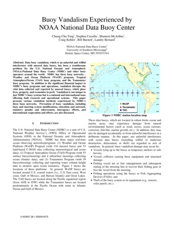
Recent Examples of ValuableObservationsUnusual case of a marine observationsupporting the estimated peakintensityHurricane Barry (July 2019)
Recent Examples of HelpfulObservationsDorian (Sep. 2019)Peak Wind SpeedsVery useful data, but rare that peakwinds in a tropical cyclone areobservedby a buoy!
Recent Examples of ValuableObservationsObserving Minimum Sea LevelPressureBuoys occasionally provide minimum sea levelpressure data. Even if the storm’s center does notpass directly over the buoy, minimum pressure canbe estimated by pressure and wind data.Dorian Passes Over NOAA Buoy41004
Data Summaries Can Be Very Insightful
Analyzing Size of a Tropical Cyclone’s WindFieldWIND RADII NHC analyzes and forecasts the wind radii in four quadrantsRadii are the largest distancefrom the center in a quadrantNW NESESW0SW0NW.64 KT. 30NE 40SE50 KT. 80NE 70SE 40SW 40NW.34 KT.150NE 150SE 140SW 100NW.Leads to an inherentover-estimate of radii,especially near land
Typical Tropical Cyclone AnalysisUncertaintySince there are insufficient observations ofsurface wind in tropical cyclones:Intensity estimates are believed to begood to within 10%Tropical storm wind radii (size estimate)are believed to be good to within 25%and hurricane wind radii to within 40%Buoy data helps lower theseuncertaintiesA 100 mph hurricane could havemaximum winds of90 mph o110 mphTropical-storm-force wind radii of 100n mi could mean a size of 75 n mi or125 n mi
Recent Examples of ValuableObservations200Buoy observations help analyzethe tropical-storm-force windradii during Hurricane Humberto(Sep. 2019)inm190 n miWind radii drive timing information andNHC’s probabilistic guidance90 nmiThree buoys reporting neartropical storm strength winds indifferent storm quadrants
Maria (2011) as a Tropical DisturbanceProduces a Huge Wave Field330240
Recent Examples of ValuableObservationsBuoys reporting 12 ft (3.5 m)seas of greaterObservations helpanalyze the 12 ft(3.5 m) seas duringHurricane Humberto(Sep. 2019)
Recent Examples of ValuableObservationsObserving Sea SurfaceTemperature ChangesCan be useful to determine amount ofupwelling that has occurred along the path ofa tropical cyclone.Would be useful to have SST depthinformation for modeling.
Recent Examples of ValuableObservationsDrifting Buoys with that Report Sea Level PressureOnlyare Also Useful for Analysis and ModelingSample of Drifting Buoys in theDrifting Buoys NearLorenzo
Buoy Observations Have SignificantContributions in Numerical Modeling**Credit Paul Poli, E-SURFMAR Programme Manager
Buoy Reports Can Help ForecastersProvide Accurate Spot Forecasts inSupport of U.S. Coast Guard OperationsSupporting Life-Saving Operations
Most Useful Data Buoy Parameters andFrequency for TC Analysis and MarineForecastingNot just top of the hour data!Peak 1-minute wind data during the hour, 10-minfrequency is ideal (NDBC continuous wind standard), airtemp and dewpoint tooPeak 3-sec wind gust during the hourMinimum surface pressure during the hourHourly reported peak seas (sig wave height)Ocean temperature & salinity at depth ( 100m) for
Supplemental Data from NOAA Buoys inAreas Typically Affected by TropicalCyclonesSeveral NOAA Buoys across theAtlantic, Caribbean, and Gulf ofMexico report the following dataeach hour:Minimum pressure dataPeak 1-minute windobservationsPeak wind gusts10-min observations
Full NHC Recommended enhancements forRIRestoreW. AfricanRadiosondenetworkNTASNEW
Bare minimum (10) NHC Recommended enhancements for RIRestoreW. AfricanRadiosondenetworkNTASNEW
Bare minimum (10) NHC Recommended enhancements (wide grid)New lineNTASRestoreW. AfricanRadiosondenetwork
Most Useful Data Buoy Parameters and Frequency for TC Analysis and Marine Forecasting Not just top of the hour data! Peak 1-minute wind data during the hour, 10-min frequency is ideal (NDBC continuous wind standard), air temp and dewpoint too Peak 3-sec wind gust during the hour Minimum surface pressure during the hour