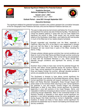
Transcription
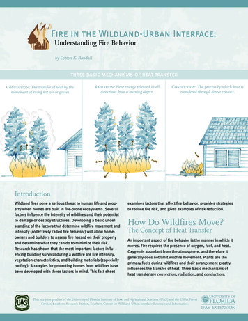
Fire in the Wildland-Urban Interface:Understanding Fire Behaviorby Cotton K. Randallthree basic mechanisms of heat transferConvection: The transfer of heat by themovement of rising hot air or gassesRadiation: Heat energy released in alldirections from a burning object.Conduction: The process by which heat istransfered through direct contact.IntroductionWildland fires pose a serious threat to human life and property when homes are built in fire-prone ecosystems. Severalfactors influence the intensity of wildfires and their potentialto damage or destroy structures. Developing a basic understanding of the factors that determine wildfire movement andintensity (collectively called fire behavior) will allow homeowners and builders to assess fire hazard on their propertyand determine what they can do to minimize their risk.Research has shown that the most important factors influencing building survival during a wildfire are fire intensity,vegetation characteristics, and building materials (especiallyroofing). Strategies for protecting homes from wildfires havebeen developed with these factors in mind. This fact sheetexamines factors that affect fire behavior, provides strategiesto reduce fire risk, and gives examples of risk reduction.How Do Wildfires Move?The Concept of Heat TransferAn important aspect of fire behavior is the manner in which itmoves. Fire requires the presence of oxygen, fuel, and heat.Oxygen is abundant from the atmosphere, and therefore itgenerally does not limit wildfire movement. Plants are theprimary fuels during wildfires and their arrangement greatlyinfluences the transfer of heat. Three basic mechanisms ofheat transfer are convection, radiation, and conduction.This is a joint product of the University of Florida, Institute of Food and Agricultural Sciences (IFAS) and the USDA ForestService, Southern Research Station, Southern Center for Wildland-Urban Interface Research and Information.
Convection: The transfer of heat by the movement of agas or liquid is called convection. Because hot air rises,can only occur within the same object or between objectsthat are touching.heat transfer through convection tends to move upward.During wildfires, burning materials on the forest floor create convection currents that preheat the leaves andbranches of shrubs and trees above the fire. The verticalair currents can also lift burning materials. The floatingembers, also called firebrands, can settle in unburnedareas ahead of the fire and start small fires. This phenomenon is called spotting and can result in rapid advancementof the fire. Firebrands can also ignite homes directly if theyland on flammable roofing or accumulations of leaves orneedles in gutters or on roofs.With an understanding of the fundamentals of heat transfer, one can see how the arrangement of plants can determine the movement of a wildfire. If flammable vegetation isabundant and continuous, all three mechanisms may interact to produce a rapidly advancing fire. Plants near the fireare dried, preheated, and even ignited through the effectsof convection and radiation. Conduction preheats and drieslarger fuels that are touching each other and may prolongthe time those fuels burn by facilitating the internal transfer of heat.Radiation: Burning objects release energy in the form ofWhat Determines Fire Behavior?heat. You feel radiant heat when you stand near burninglogs in a fireplace. In general, the size of the burningobject determines the amount of radiant heat released,with larger fuels burning hotter. In most cases, radiantheat from a wildfire will not ignite materials on homes atdistances greater than 30 feet from the house. During prescribed fires in the wildland-urban interface, fire professionals carefully monitor the amount of radiant heat beingreleased from the flaming fire front (Figure 1). Prescribedfires are set intentionally and strictly controlled to meetland management objectives.Figure 1. The vertical flames in this prescribed fire demonstrate theconvective air currents carrying heat, smoke, and firebrands verticallyinto the sky. The smoke and firebrands can cause problems if they settleon roads or houses. In this picture, firefighters are standing betweenthe fire and the house to detect the radiant heat being released and willhose the fire down if it gets too hot.Photo Credit: Cotton RandallPhoto Credit: Cotton RandallMultiple factors interact to determine the behavior of wildland fires. Fire behavior refers to the intensity at which afire burns and how it moves. General descriptions of wildfire behavior focus on where the fire occurs in the vegetation: underground, on the surface, and in tree crowns.Ground fires are fires that burn below the surface. In theSouth, muck fires are a type of ground fire where deadplant materials burn and smolder below the surface in drywetlands (Figure 2). During surface fires, fuels at or nearground level, such as grass, shrubs, and/or fallen leavesand branches, carry the fire (Figure 3). Crown fires burnthrough the tops of trees (Figure 4). In general, the relativeintensity (amount of heat released) of the different types ofwildfire increases from ground to surface to crown fires.Firebrands may originate from surface fires or crown fires.Conduction: The last mechanism of heat transfer is fromdirect contact or conduction. An example of conduction isFigure 2. A ground fire burned the peat in a baldcypress swamp andcreated the hole that contains standing water in this photo.the heat that you feel when you touch a cup of hot water.Conduction carries heat through fuels, such as logs orhouse walls, and can raise the temperature of fuels to thepoint that they ignite. Heat transfer through conductionStructural fires, or burning homes or buildings, are anothertype of fire that can produce firebrands. Three factors interact to determine fire behavior in wildland fires: fuels,weather, and topography.2Fire in the Wildland-Urban Interface: Understanding Fire Behavior
because they ignite easily and burn rapidly. Light fuelsaffect the rate of spread of an advancing fire. They are theprimary fuels that carry fires and ignite homes in manywildfire situations.Fuels: The primary fuels in wildland fires are living anddead vegetation. During extended periods of warm and dryconditions, all plants will burn if exposed to enough heat.However, plants differ in how readily they ignite and howhot or long they burn. Flammability depends on plant size,arrangement of branches and leaves, and chemical properties of leaves, branches and bark (see fact sheet "Selectingand Maintaining Firewise Plants for s/fact sheets/Selecting and Maintaining Firewise Plants.pdf). Both thehorizontal and vertical arrangement of vegetation influences fire behavior. The arrangement of vegetation acrossa tract of land is influenced by the frequency of past disturbance. Wildfire is a natural disturbance that reduces theamount of dead plant material and light fuels at a site. Acommon firefighting technique for slowing or stopping anadvancing wildfire involves creating breaks in the fuels byclearing all vegetation from strategic locations. Fire professionals have a few key terms that they use to describewildland fuels.Heavy fuels, such as large tree branches, downed logs,and buildings, require more heat energy to ignite, but theyburn longer and produce more heat once ignited.Ladder fuels are shrubs or small trees of intermediateheight that act as ladders carrying the flames from the forest surface up into the tops of trees (Figure 5). Vines climbing up trees can also act as ladder fuels.Fuel breaks are areas lacking vegetation or other fuelsPhoto Credit: Dale Wade, USDA Forest Servicethat stop or impede the horizontal movement of an advancing fire. Fuel breaks can be natural, such as rivers orstreams, or artificial, such as roads or plowed agriculturalfields.Figure 5. Ladder fuels are medium-sized shrubs or trees that connectfuels at the forest floor to the tree crowns.Weather: Precipitation, humidity, wind, and temperatureFigure 3. This surface fire burns through understory shrubs during aprescribed burn in a southern pine forest.Photo Credit: Dale Wade, USDA Forest Serviceare important weather variables that influence fire behavior. Precipitation and humidity, which are influenced by airtemperature, directly influence the flammability of forestfuels by affecting the moisture content of living and deadleaves, branches, and grasses. Plant materials dry outquicker and ignite easier during hot, dry weather. Windyconditions increase the rate of spread of fires and mayincrease fire intensity.Firefighting professionals have developed fire dangerindices, which are classification sytems that incorporatecurrent weather conditions into an index to rate fire risk.Many Southern states post current fire danger indices ontheir websites during the wildfire season (see appendix forlinks). The Keetch-Byram drought index is a commonlyused drought index associated with wildland fire dangerthat provides an estimate of dryness in the soil.Figure 4. This high intensity crown fire exhibits long flames that aresupported by and carried through the crowns of trees.Light fuels include grasses, shrubs, and tree leaves orneedles. They are referred to as light and flashy fuels3Fire in the Wildland-Urban Interface: Understanding Fire Behavior
low concentrations of oils or other flammable chemicals inthe leaves and branches (e.g. succulent plants), and anopen and loose branching pattern (see the fact sheets"Selecting and Maintaining Firewise Plants forLandscaping" and "Preparing a Firewise Plant List for WUIResidents" listed at the back of this fact sheet for moreinformation).Topography: Topography significantly affects fire behavior. Fires move faster uphill than downhill. Slope orientation also influences fire behavior. Forests on southern orsouthwestern slopes generally have lower humidity andhigher temperatures than those on north or northeastslopes because of the path of the sun. Consequently, firehazard is often higher on south and southwest facing hills.Maintain healthy landscape plants by watering asneeded and removing dead branches.Of the three factors affecting fire behavior, fuels are theeasiest to manage by homeowners and land managers tolower fire hazard.If natural areas exist on your lot, you can reduce theintensity of an approaching fire by: (1) removing highlyflammable shrubs and trees; (2) reducing overall treedensity by removing small trees (called thinning); and(3) reducing the continuity of ladder fuels. This modified area can serve as a buffer between unaltered natural areas and the modified area of defensible space.Strategies to Reduce the Risk ofHigh Intensity FiresHomeowners: Homeowners in high fire hazard areas canreduce the risk of high intensity fires affecting their property. You can determine your particular fire risk by using theon-line Wildfire Risk Assessment at http://www.interfacesouth.org/products/widlfire ra.html. This assessment isalso available as a pdf document at http://www.interfacesouth. org/fire/ WildfireRAGH.pdf. An important concept forhomeowners living in hazardous areas is that of defensiblespace. Defensible space is defined as an area of modifiedvegetation between wildland fuels and homes that allowsfirefighters to protect the home or, in the absence of firefighters, allows the home to better survive on its own. Themost extensive modification of vegetation should occurwithin an area of at least 30 feet around the house. Beyondthis area, additional modification of wildland vegetationcreates a larger buffer from an approaching wildfire andfurther decreases the risk of damage.Land Managers: Individuals who manage larger tractsof woodlands surrounding developed areas can alsoreduce the risk of high intensity fires. This is particularlyimportant if the lands have a high fire hazard, such asmany southern pine forests. Fuel reduction on these landsshould focus on, but not be restricted to, creating 30-footwide buffers at the edges of the property next to residential or commercial developments. When prescribed fire isused to manage these buffers, a zone extending from 50 to100 feet into the forest or natural area is usually burned.Fuel reduction at the interface between natural lands anddevelopments can reduce the intensity of the fires beforethey enter populated areas. Land managers have severaloptions to reduce fuels: prescribed fire, mechanical reduction (using mowers or other equipment), herbicides, andgrazing animals. Land managers need to check local ordinances for restrictions on the use of these treatments.Create and maintain a defensible space by removingthe lower branches up to 10 feet from the ground onlarge trees, separating beds of landscape plants, andremoving flammable vegetation from within 30 feetfrom your house. Homeowners living on a steep slopeor hillside should maintain a larger primary zone ofdefensible space by clearing flammable vegetation upto 100 feet around the house. Consult your localforester (http://southernforests.org/sgsf members.aspx) or extension agent (http://www.csrees.usda.gov/Extension/index.html) to determine the appropriatearea of defensible space for your neighborhood.Applying Fire Behavior Knowledgeto Assess Fire HazardWith a basic understanding of fire behavior, we can rapidlyassess the relative fire hazard of different landscapes.Consider the following two examples:Landscapes A and B: Landscape A, a natural forestcomposed of mature pine trees and a dense understory ofhardwood shrubs and small trees, is left unmanaged within 15 feet of a woodland home (Figure 6). Fire has beenexcluded from the forest for more than 10 years.Landscape your yard with firewise plants with the following characteristics: slow growth with little accumulation of dead vegetation, high moisture content and4Fire in the Wildland-Urban Interface: Understanding Fire Behavior
a surface fire due the lack of sufficient understory fuels tosustain it. Assuming that only a surface fire develops inLandscape B, how do the same three potential home ignition sources fare? Compared to the sources of ignition forthe home in Landscape A: (1) the risk of ignition from firebrands would be lower than with Landscape A becausethere are fewer plants to produce firebrands; (2) the 30feet of defensible space reduces the amount of radiantheat to which the house is exposed and consequently,reduces the preheating or ignition of interior items andexterior features of the house; and (3) the defensible spacereduces the chance of any flames reaching the exteriorwalls of the house.Landscape B also includes a natural pine forest locatedadjacent to a housing development (Figure 7). However, theowner of this pine forest has implemented a fuel reductionprogram that involves the removal of all ladder fuels withina 100-foot buffer of the development and the use of prescribed fire every three to five years to reduce surfacefuels, such as dead pine needles, downed branches, grasses, and shrubs. Notice the vertical and horizontal separation of fuels in Landscape B. In addition, the homeownercreated a 30-foot area of defensible space.ConclusionsWhen wildfires occur near homes, homeowners often feelpowerless to protect their property. An approaching firemay seem unpredictable and difficult for trained firefighters to control. However, with an understanding of the concepts of fire behavior outlined in this paper, you can anticipate the intensity and movement of a fire by consideringseveral key conditions: fuel structure, local weather, andtopography. Furthermore, by altering the conditionsaround your house, such as the arrangement of landscapevegetation, type of vegetation, and distance of vegetationfrom the house, you can influence the movement andintensity of fires, and consequently, improve the survivability of your home.Figure 6. Landscape A with an unmanaged surrounding forest andinsufficient defensible space.Figure 7. Landscape B with a managed pine forest and appropriatearea of defensible space.Predicted Fire Behavior: In Landscape A, the presenceof ladder fuels could facilitate the development of a highintensity crown fire in the surrounding forest. Even withouta crown fire, the fire could exhibit a rapid rate of spreadthrough the understory and high radiation (hot temperatures). The potential for firebrands would also be great.Possible sources of ignition for the home would be: (1) firebrands landing on the roof or entering the vents, (2) radiant heat igniting blinds through the windows or raising thetemperature of the house’s exterior to the point of ignition,or (3) flames carried directly from the forest to the side ofthe house through burning fuels (shrubs, pine needles, drygrasses, or dead leaves).ReferencesCalifornia Department of Forestry and Fire Protection.2000. Structural Fire Prevention Field Guide: For Mitigationof Wildland Fires. California Department of Forestry andFire Protection, Office of the State Fire Marshal, USDAForest Service, USDI Bureau of Land Management.Cohen, J. D. 2000. Preventing disaster: home ignitability inthe wildland-urban interface. J. For. 98(3): 15-21.Foote, E. I. D. and J. K. Gilless. 1996. Structural survival. Pp.112-121 in R. Slaughter’s (editor) California’s I-zone. Stateof California.In Landscape B, a low intensity surface fire could developin the surrounding forest. With the absence of ladder fuelsand a lower density of pine trees, the likelihood of a crownfire developing is significantly less than in Landscape A. Ifa crown fire should reach this forest, it may be reduced toPyne, S. J., P. L. Andrews, and R. D. Laven. 1996.Introduction to Wildland Fire. Second Edition. John Wiley &Sons, Inc. New York.5Fire in the Wildland-Urban Interface: Understanding Fire Behavior
For more informationViegas, D. X. 1998. Weather, fuel status and fire occurrence: predicting large fires. Pp. 31-48 in J. M. Moreno(ed.), Large Forest Fires. Backhuys Publishers, Leiden, TheNetherlands.or questions contact Annie Hermansen-Báez of the USDAForest Service, Southern Research Station at (352) 3763271, ahermansen@fs.fed.us or Alan Long of the Universityof Florida at (352) 846-0891, ajl2@ufl.edu.Other fact sheets in the series“FIRE IN THE WILDLANDURBAN INTERFACE”AppendixFire Danger indices/maps on the web:(http://edis.ifas.ufl.edu/TOPIC SERIESFire in the Wildland Urban /fd/bbmap png.php3Florida: http://flame.fl-dof.com/fire weather/index.htmlCircular 1431: Fire in the Wildland-Urban Interface:Considering Fire in Florida's EcosystemsGeorgia: http://weather.gfc.state.ga.us/Maps/fd.gifCircular 1445: Fire in the Wildland-Urban Interface:Selecting and Maintaining Firewise Plants forLandscapingNorth Carolina: http://www.dfr.state.nc.us/fire control/fire .ou.edu/models/fire/Circular 1453: Fire in the Wildland-Urban Interface:Preparing a Firewise Plant List for WUI ResidentsSouth Carolina: http://www.dnr.sc.gov/climate/scoCircular 1478: Fire in the Wildland-Urban Interface:Reducing Wildfire Risk While Achieving OtherLandscaping GoalsTexas: http://www.tamu.edu/ticc/predictive services/fuels.htmThis fact sheet is available on-line on the Southern Centerfor Wildland-Urban Interface Research and Information’swebsite, InterfaceSouth, at http://www.interfacesouth.org/products/fact sheets/Understanding Fire Behavior.pdf.It can also be found on the UF/IFAS EDIS website asCircular 1432.Virginia: http://www.dof.virginia.gov/fireNational map:http://www.fs.fed.us/land/wfas/fd class.gifPermissions andAcknowledgementsThe author of this publication gives permission to reproduce this fact sheet. Cotton K. Randall is the formerWildland-Urban Interface Fire Project Coordinator at theSchool of Forest Resources and Conservation, Institute ofFood and Agricultural Sciences, University of Florida.The development of the information in this fact sheet wasfunded by the National Fire Plan through the USDA ForestService, Southern Research Station, Southern Center forWildland-Urban Interface Research and Information. JulissaM. Hernandez is acknowledged for her creative illustrations and for designing the layout of this publication.6Fire in the Wildland-Urban Interface: Understanding Fire Behavior
Notes7Fire in the Wildland-Urban Interface: Understanding Fire Behavior
The Institute of Food and Agricultural Sciences (IFAS) is an Equal Opportunity Institution authorized to provide research, educational information andother services only to individuals and institutions that function with non-discrimination with respect to race, creed, color, religion, age, disability, sex,sexual orientation, marital status, national origin, political opinions or affiliations. U.S. Department of Agriculture, Cooperative Extension Service,University of Florida, IFAS, Florida A.&M. University Cooperative Extension Program, and Boards of County Commissioners Cooperating.
Fuels: The primary fuels in wildland fires are living and dead vegetation. During extended periods of warm and dry conditions, all plants will burn if exposed to enough heat. However, plants differ in how readily they ignite and how hot or long they burn. Flammability depends on plant size,