Transcription
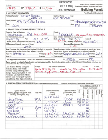
RECEIVEDFor office use:APR 2 0 2016 1IL :Lca '23Tracking No.Permit No.1. APPLICANT INFORMATIONApplicant Name(s) \'Y'tO.\\ C -t-MAINE lAND USE PLANNING COMMISSIONDepartment ofAgriculture, Conservation and ForestryBuilding PermitFee ReceivedFor All Residential Development\0f'4U(Y) l. tlo2. PROJECT LOCATION AND PROPERTY DETAILSTownship, Town or Plantation}CL":1"' U1oLQ.MD 0 -e jTax Information (check t.fx bi/Q.,. -Plan:C .SLot size (in acres, or in square feet if less than 1 acre)All Zoning on Property (che t the LUPC map)Lot:jrilo\jSl:- -·-------------.,C-o-un-ty \ \ .qQOC O\.LbA?De 8 J'f\ IDeed or Lease Information (check deed or lease)IBook: 'dPage: ?J \5Lea s e #: c9clk lo:I L.,., ,-----!lt.ot Coverage (in u feet) 5 kLZoning at Development Sitep- .::: .;:11 - - - - - - [--V\·l· .sRoad Frontage. List the name(s) and frontage(s) (in feet) for any public Jwater Frontage. List the name(s) and frontage(s) (in feet) for any lakes,or private roads, or other rights-of-way adjacent to your lot: . 1ponds, rivers, streams, or ot : watrrs on or adjacent to your lotRoad#1:Road #2:Q9.: \o- DFrontagej(j s--tt. j Waterbody#1:U -\Ze\J Frontageft. 1Waterbody #2:\Y\\-. fb.d Frontage ;i6'1 ft.ft.FrontageLUPC Approved Subdivision. List the LUPC approved subdivision number: . SP and SP LotIf your property is not part of subdivision previously approved the Commission, please continue to Land Division History below. (check your deed#:Jj'Sor contact the LUPC office that serves your area)Land Division History. Using yourdeed as a starting point. trace theownership history and configurationchanges of your property back 20 yearsfrom today. List any division of thoselots from which your property originated{use additional sheet of paper if needed).(example:Amy Adams to Rob Robertsffi;. io' l4 '-l ) B Y LY )- \93. EXISTING STRUCTURES OR USES (Fill in a line for each existing structure) 1/1211997C:. rt, D10 acres)8 -I Y - aru m , 1\ "A tG.oo Previously issued Building Permit number (if applicable)Horizontal Distance (in feet) ofstructure from nearest:'r------------------------ - - - - -·\III!r------------------------- ------- ---------------r---------- ---r---r--T---T- -- II
BP 1 ;1.RECEIVEDAPR 2 8 2016 ,-.C,LUPC- DOWNEAST4. PROPOSED STRUCTURES OR USES (INCLUDING DRIVEWAYS AND PARKING AREAS) {Use additional sheet if needed)4.1 What is the proposed use of your property? 10'Residential onlyType of structure(dwelling, garage, deck, porch, shed,driveway****, camper, RVs, parking lots,etc.)D Residential with Home Occupation*D Campsite.Horizontal Distance (in feet) ofProposal (check all that apply)structure from nearest:rz: CD::0 m ::0 ::0 o. m Q'""' 9:0""0::0::00 X!llExteriorCDc:CD:;;:·0n ::1.m.CD06'3 !llCD 0n -o03 0.-o!llCD5 3 !llCD::I0. !lln!lldimensions0-coCDU ::1::1o::I O!ll !ll::I!ll0::I;:::).0 U 0.0 0::1 @ ·CD0.c:' ::::rCii CD n(in feet)0CD-oU 2::I::I ::10.:0::;·,. .en 4.::1(LxWxH)e!.CD(I)Cl.*;t"' Cil*1,.Dfi!1' * "'3Q!ll:!:!llCiiCi1'DDDDD g D DD D DD D D DD DDDD D DD D DD D D0 0 DDDDDDDDDDDDD0 00 0DDDDDDDD\1-\''{ \ '#.\ lr?;l'D l:l \I .t \ cl l\cts . 'f.l iHoD 'i n' \'nl) I '"A l· ,\',',( \oDDDDDDDDDDDDDDDDDD\ld)l ;({6DI* 4.2 HOME OCCUPATIONS: If use of your property includes expanding or starting a home occupation, you must complete SupplementS.1: Questions for Home Occupations. Contact the LUPC office serving your area or download at www.maine.gov/dacf/lupc/. Please noteadditional fees apply to home occupations, see instructions for the appropriate fees.** 4.3 CAMPSITES: If use of your property includes a campsite for your personal use (e.g., will not be rented):a. Will the tents, tent trailer(s), pickup camper(s), recreational vehide(s), trailer(s) or similar devices be located on the lotfor less than 120 days in a calendar year?. . . . . . . . . . . . . . . . . . . . . . . . . DYES DNOb. Will the camper(s), trailer(s), and/or recreational vehicle(s) be registered and road ready? . . DYES ONOc. Will the campsite have access to an on-site pressurized water supply (and not a self-contained water tank with pump)? . DYES DNOd. Will the campsite have access to permanent structures other than an outhouse, fireplace, picnic table, or lean-tos? . DYES DNO*** 4.4 RECONSTRUCTIONS OR NEW ACCESSORY STRUCTURES: If you are constructing a new accessory structure, reconstructing anexisting structure, or adding a permanent foundation:a. If the structure or foundation will not meet the LUPC's minimum setback distances from property lines, roads, water bodies or wetlands,explain what physical limitations (lot size, slope, location of septic system, etc.) prevent the structure or foundation from meetingsetbacks:b. For reconstructions, has the existing structure been damaged, destroyed or removed from your property? . [t!'YEs DNOIf YES, was the structure in regular active use within a 2-year period preceding the damage, destruction or removal? . li21\'ES DNOIf YES, provide the date the structure was damaged, destroyed or removed: - ltJ::.Jiu1 il.,"--- - - - - - - - - - - - - - **** 4.5 DRIVEWAYS: If you are located on a public road:a. Are you constructing a new driveway or entrance or changing a current driveway in a way that will increase trafficvolume, or create a safety or drainage concern regarding a State or State-Aid Highway? .DYES DNOIf YES, you must submit Exhibit H: Driveway/Entrance Permit. Note: If your property is located along a County or Town/Plantation Road,you should check with that office before submitting this application to see what is required.5. SUBSURFACE WASTEWATER DISPOSAL (SEPTIC SYSTEM) {Note: Exhibit may be required. See instructio s)D Combined Subsurface System (Tank, leach field)5.1 Mark the existing type of system serving the property:D NoneD Common Sewer (Connected to a sewer district) Primitive Subsurface Disposal (Privy, graywater- non-pressurized);D OtherD Holding TankD Self-Contained Camper or RV5.2 Will any expanded, reconstructed, or new structures include new bedrooms or bathrooms; add plumbing, water fixtures,pressurized water, or the ability for human habitation; or otherwise generate additional wastewater? . . livE 0 NOIf YES, you may need to submit Exhibit E: Subsurface Wastewater Disposal (see instructions) fiJQh \.0. "" .! \1'\. ."
RECEIVEDAPR 2 0 2016/BP [3J t -CWPC · DOWN E A STr------------------------6. DEVELOPMENT IN FLOOD PRONE AREAS (Note: Supplement may be required. See instructions.)6.1 Is your proposed activity located within a mapped P-FP {Flood Prone AreaProtection) Subdistric a mapped FEMA (Federal Emergency ManagementAgency) flood zone, or an unmapped area prone to flooding?-u-FP Subdistrict . . . DYES 0NOFEMA Flood Zone . . . . . . . DYES BJ-,10Unmapped Area Prone to Flooding . .DYES [0NOIf you answer YES to any of these questions, you must complete Supplement S-4: Development in Flood Prone Areas. Contact the LUPCoffice serving your area or download at www.maine.aov/dactnuoc/aoolication forms/index.shtml.7. VEGETATIVE CLEARING (Note: Exhibit may be required. See instructions.)7.1 What is the total amount of proposed vegetative dearing not including thedriveway and the footprint of proposed structures? . A sq. ftIf you answer NA (not applicable) for 7.1 go to Section 8.7.2 Will the total amount of existing and proposed vegetative clearing within 250feet of any lakes or rivers be less than 10,000 square feet? . . . DYES DNO DNA Total:sq. ft.7.3 Will the proposed clearing be located at least 50 feet from the right-of-way orsimilar boundary of all public roadways? . DYESDNODNA How Close?feet7.4 Will the proposed clearing be located at least 75 feet from the normal high watermark of any body of standing water less than 10 acres in size, any tidal water, orflowing water draining less than 50 square miles? . DYESDNODNA How Close?feet7.5 Will the proposed clearing be located at least 100 feet from the normal highwater mark of the lake or river? . DYESDNODNA How Close?feet7.6 If you answer NO to any of these questions, please explain why your vegetative dearing proposal is necessary and how it will not create anundue adverse impact on the resources and uses in the area:7. 7 Buffering in Prospectively Zoned Areas. Is your property located in one of the following Prospectively Zoned Plantationsor Townships?. . . . . . . . . . . . . . . . . DYES DNOAdamstown Twp.Rangeley Pit.Dallas Pit.Richardsontown Twp.Lincoln Pit.Sandy River Pit.Magalloway PitTownships C, D, and E.If YES, please complete the following table regarding the width of the vegetative buffers at the narrowest point between the existing andproposed structures and the nearest applicable road, property line, and subdistrict setbacks as applicable:StandardMinimumRequired:This property:Road25 feet in D-GN, D-GN2, D-GN350 feet in D-RS, D-RS2, D-RS375 feet in D-ES and 0-CIfeetIIIWidth of VeQetated BuffersSide Property LineRear Property Line15 feet50 feet Buffer to other Subdistricts15 feetfeetSubdistrict Boundary (If D-ES or D-C I)feetfeetNote: You may be required to submit Exhibit F: Documentation for Exceptions to Buffering Requirements. See instructions)8. SOIL DISTURBANCE, FILLING AND GRADING AND EROSION CONTROL (Note: Exhibit may be required. See instructions.)8.1 Will your project involve disturbing soil or filling and grading? . DYES 0If YES, please answer the following questions. If NO. continue to Section 9.8.2 What is the total area of proposed soil disturbance or filling and grading?.sq. ft.8.3 What is the total square feet of soil disturbance or filling and grading within 250 feet of a body of standing water, flowingwater, or wetland?.sq. ft.8.4 Will all soil disturbance or filling and grading be done when the ground is frozen or saturated? . . DYES DNOIf YES, you will need to submit Exhibit G: Erosion and Sedimentation Control Plan8.5 Will any fill used be free of hazardous or toxic materials, trash and rubbish? . DYES DNO8.6 How and when will disturbed areas be seeded or stabilized at the end of the construction season and at the completionof the project?Question 8 continues onto the next page .
APR 2 0 2016 1LUPC DOWNEAST8. SOIL DISTURBANCE, FILLING AND GRADING AND EROSION CONTROL (continued from previous page)8. 7 What will you do (during site preparation, construction, cleanup, and post-construction) to stabilize disturbed soil and prevent sediment fromentering water, wetlands, natural drainage systems, catch basins, culverts or adjacent properties?8.8 What is the average slope of land between the area to be disturbed and the nearest waterbody or wetland?.%slope8.9 What will the sustained slope of land be between the area to be disturbed and the nearest waterbody or wetland?.%slope8.10 Please explain how your project will not create an undue adverse impact on the resources and uses in the area. Include information abouterosion control devices and other plans to stabilize the site: Be sure to include the following information on your site plans (Exhibits 01 and 02): size and location of the area to bedisturbed, and the proximity of the area to be disturbed to water bodies, flowing waters, and wetlands.9. LAND AND WETLAND ALTERATION (Note: Exhibit or Supplement may be required. See instructions.)9.1 Will your proposal alter a total of one acre or more of land area, whether upland or wetland?. . . . . . . . . . . DYES NOIf YES, you must also complete Exhibit G: Erosion and Sedimentation Control Plan and Supplement S-3: Requirements forWetland Alterations.9.2 Will your proposal alter any amount of land that is mapped P-WL Subdistrict, or any ground below the normal high watermark of any lake, pond, river, stream, or intertidal area? . . DYES 0If YES, you must also complete Supplement S-3: Requirements for Wetland Alterations.Mailing AddressEmailTownStateZip CodeI have personally examined and am familiar with the information submitted in this application, including the accompanying exhibits and supplements,and to the best of my knowledge and belief, this application is complete with all necessary exhibits. I understand that if the application is incompleteor without any required exhibits that it will result in delays in processing my permit decision. The information in this application is a true and adequatenarrative and depiction of what currently exists on and what is proposed at the property. I certify that I will give a copy of this permit and associatedconditions to any contractors working on my project. I understand that I am ultimately responsible for complying with all applicable regulations andwith all conditions and limitations of any permits issued to me by the LUPC. If there is an Agent listed above, I hereby authorize that individual orbusiness to act as my legal agent in all matters relating to this permit application. I understand that while there is a required Statewide Maine UniformBuilding and Energy Code {MUBEC) administered by the Maine Department of Public Safety, Bureau of Building Codes & Standards, theCommission's review is limited only to land use issues and the Commission does not make any findings related to the MUBEC, nor do the LUPC staffinspect buildings or enforce any provisions of that Code.Pie e check one of the boxes below: (see "Accessing the Project Site for Site Evaluation and Inspection" just prior to the application form)I authorize staff of the Land Use Planning Commission to access the project site as necessary at any reasonable hour for the purpose ofevaluating the site to verify the application materials I have submitted, and for the purpose of inspecting for compliance with statutory andregulatory requirements, and the terms and conditions of my permit.
1Tf u(i 3IBP I3]Trac! ing No.RECEIVEDAPR 2 0 2ma;Ila-C.Permit No.EXHIBIT 0·1: SITE PLANWPC- 00\NNEASTPrepare a bird's-eye view site plan that shows your entire property and indudes all the elements described for Exhibit 0 in the instructions. Do notuse colors. Refer to the instructions for a sample site plan.Ii.\ I r t--.t""-'\C:c::: :;::oo-.\II' j"Vt-J "f-1Il/1 i\I . II(-/t\.,.,.'(')I/'I .[',.ii ' Ir :III r.7::,;"". -.:::;;- .,. I- I, I Ivfr--I ln I lI : Ir-I .- pr( 1I 'IIIIIIi7i\IIiIlI', ,.II. !---'!IIAII\Notes/Legend:I.;'Ilc ·II.I.i'I'- ILI ?\ De.' II,. .--Ii-'I"I I,, .) , ' . . . .!--P IIiII,0L .cj;;J -'pn .,.!. ( i-""'" F' " j " - ·r;',AI Iltrlllr4I-I0""VI '7 j- D")III 1/ ' J 'II"" .t--IbI' " V'\"'V/I.161til,. 0!.l:fIIII dt--'r r- i--II"DI!IL. I"\1\"I'\ 'if \' c \'II f0\III
AMENDMENT C TO BUILDING PERMIT BP-3712MAINE LAND USE PLANNING COMMISSIONDepartment of Agriculture, Conservation and ForestryBased on the information you have submitted in the attached application and supporting documents, the staff of the Land Use PlanningCommission concludes that, if carried out in compliance with the conditions of approval below, your proposal will meet the criteria forapproval, 12 M.R.S. § 685-B(4) of the Commission’s statutes and the provisions of the Commission’s Land Use Districts and Standards(Chapter 10; ver. December 07, 2015). Any variation from the application or the conditions of approval is subject to prior Commissionreview and approval. Any variation undertaken without Commission approval constitutes a violation of Land Use Planning Commissionlaw. In addition, any person aggrieved by this decision of the staff may, within 30 days, request that the Commission review the decision.April 21, 2016LUPC Authorized SignatureEffective DateCONDITIONS OF APPROVALGeneral Conditions1. At least one week prior to commencing the permitted activities, the permittee or the designated agent must contact theCommission staff and notify them of the estimated date construction work will start. Notice may be provided in writing, in person,by email, or by calling. If you leave or send a message, please include your full name, telephone number, permit number, andthe date the work will start.2. All authorized structure(s) must be set back a minimum of 100 feet from the normal high water mark of Upper LeadMountain Pond, 75 feet from the upland edge of P-WL1 wetlands, 50 feet from the 29-10-00 Road and 15 feet from otherproperty boundary lines.3. The authorized structure(s) must not exceed 30 feet in height as measured as the vertical distance between the mean original(prior to construction) grade at the downhill side of the structure and the highest point of the structure, excluding chimneys,steeples, antennas, and similar appurtenances that have no floor area.4. Construction activities authorized in this permit must be substantially started within 2 years of the effective date of this permitand substantially completed within 5 years of the effective date of this permit. If such construction activities are not started andcompleted within this time limitation, this permit shall lapse and no activities shall then occur unless and until a new permit hasbeen granted by the Commission.5. This permit is dependent upon and limited to the proposal as set forth in the application and supporting documents, except asmodified by the Commission in granting this permit. Any variation is subject to prior review and approval of the Maine Land UsePlanning Commission. Any variation from the application or the conditions of approval undertaken without approval of theCommission constitutes a violation of Land Use Planning Commission law.6. Structures authorized under this permit, as well as filling/grading/soil disturbance and cleared openings created as part ofconstruction activities authorized under this permit, must be located to meet the road, property line, water and wetland setbackdistances, exterior dimensions and building heights listed in Sections 4 and 5 and approved by this permit.7. Temporary and permanent sedimentation control measures must be implemented to effectively stabilize all areas of disturbedsoil and to catch sediment from runoff water before it leaves the construction site so that sediment does not enter water bodies,drainage systems, water crossings, wetlands or adjacent properties. Clearing and construction activities, except thosenecessary to establish sedimentation control devices, shall not begin until all erosion and sedimentation control devices(including ditches, culverts, sediment traps, settling basins, hay bales, silt fences, etc.) have been installed and stabilized. Oncein place, such devices shall be maintained to ensure proper functioning.8. Effective, temporary stabilization of all disturbed and stockpiled soil must be completed at the end of each work day. Alltemporary sedimentation and erosion control devices shall be removed after construction activity has ceased and a cover ofhealthy vegetation has established itself or other appropriate permanent control measures have been effectively implemented.Permanent soil stabilization shall be completed within one week of inactivity or completion of construction.9. Cleared openings created as part of construction activities authorized under this permit must be effectively stabilized andrevegetated.10. All imported fill material must be free of hazardous or toxic materials and must not contain debris, trash, or rubbish.11. Unless otherwise proposed in Question 8.4 and by the submittal of Exhibit G, Erosion and Sediment Control Plan, andapproved by this permit, soil disturbance must not occur when the ground is frozen or saturated.MAINE LAND USE PLANNING COMMISSIONBuilding Permit for Residential DevelopmentAmendment C to BP 3712; LUPC Decision & ConditionsPage 1 of 2
12. Topsoil must not be removed from the site except for that necessary for construction activities authorized in this permit. Topsoilmust be stockpiled at least 100 feet from any water body.13. The permittee shall not advertise Land Use Planning Commission approval without first obtaining approval for such advertising.Any such advertising shall refer to this permit only if it also notes that the permit is subject to conditions of approval.14. In the event the permittee should sell or lease this property, the buyer or lessee shall be provided a copy of the approved permitand conditions of approval. The new owner or lessee should then contact the Land Use Planning Commission to have thepermit transferred into his/her name. If there are no additional changes the transfer can be accomplished on a Minor ChangeForm.15. All exterior lighting must be located and installed so as to illuminate only the target area to the extent possible. Exterior lightingmust not produce a strong, dazzling light or reflection beyond lot lines onto neighboring properties, water bodies, or roadway soas to impair driver vision or to create nuisance conditions.16. The scenic character and healthful condition of the area covered under this permit must be maintained. The area must be keptfree of litter, trash, junk cars and other vehicles, and any other materials that may constitute a hazardous or nuisance condition.17. The permittee shall secure and comply with all applicable licenses, permits, authorizations, and requirements of all federal,state, and local agencies including but not limited to: Air and Water Pollution Control Regulations; Subsurface WastewaterDisposal System approval from the Local Plumbing Inspector and/or Maine Department of Health and Human Services,Subsurface Wastewater Program; and the Maine Department of Transportation, Driveway Entrance Permit, a physical E-911address from your County Commissioner’s Office.18. Once construction is complete, the permittee shall submit a self-certification form, notifying the Commission that all conditions ofapproval of this permit have been met. The permittee shall submit all information requested by the Commission demonstratingcompliance with the terms of this permit.19. Upon completion of the authorized structures within the terms of this permit, any existing structures authorized to be removedfrom the lot and other construction debris must be disposed of in a proper manner, in compliance with applicable state andfederal solid waste laws and rules.20. All conditions of previously issued Commission permits shall remain in effect, except as specifically modified by this permit. Forparcels that are part of a Commission-approved subdivision, all conditions of the subdivision permit as they pertain to thepermittee’s parcel shall remain in effect.MAINE LAND USE PLANNING COMMISSIONBuilding Permit for Residential DevelopmentAmendment C to BP 3712; LUPC Decision & ConditionsPage 2 of 2
8. SOIL DISTURBANCE, FILLING AND GRADING AND EROSION CONTROL (continued from previous page) 8. 7 What will you do (during site preparation, construction, cleanup, and post-construction) to stabilize disturbed soil and prevent sediment from entering water, wetlands, natural drainag