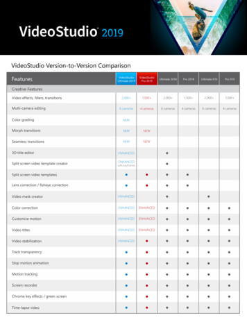
Transcription
Building an Enterprise version of GeMS (formerly NCGMP09 map schema)By Jennifer Athey, Michael Hendricks, and Patricia GallagherAlaska Division of Geological & Geophysical Surveys3354 College RoadFairbanks, Alaska 99709Jennifer AtheyTelephone: (907) 451-5028email: jen.athey@alaska.govMichael HendricksTelephone: (907) 451-5029email: michael.hendricks@alaska.govPatricia GallagherTelephone: (907) 451-5039email: patricia.gallagher@alaska.govAbstractThe Alaska Division of Geological & Geophysical Surveys (DGGS) was awarded a U.S.Environmental Protection Agency (EPA) – Environment Information Exchange Network grant in2016. One of the grant deliverables includes the development of a multi-map, multi-user “enterprise”database model based on the single-map Geologic Map Schema (GeMS) developed by the USGS andstate geological surveys (NCGMP, 2010). The enterprise version of GeMS in development isultimately intended for national use, as is a pilot data-sharing protocol to be developed with themodel. To date, DGGS and other stakeholders in the geologic community have determinedspecifications for the enterprise database, begun testing the PostgreSQL-ArcGIS for Serverenvironment, and initiated re-scoping of the GeMS data model to meet the specifications. Thedevelopment process is designed to be collaborative; interested persons are encouraged to contactDGGS for information.Slide 1. DGGS constantly reviews its business practices to identify ways to meet customerexpectations and future-proof products and processes while more efficiently spending resources suchas time, staff, and money. In other words, we strive to “do more with less.” DGGS has identifiedenterprise-style data management as a way to increase both output and efficiency. Changes in datamanagement will likely take many forms affecting internal and external data users, such as movestoward increased standardization, data centralization, interoperability, and accessibility. However,fundamental changes in DGGS business processes will happen gradually.Slide 2. One big driver of change is a 3-year EPA Exchange Network grant awarded to DGGS in2016. The grant has three goals, each with a related deliverable. Goal 2 focuses on the developmentof a multi-map, multi-user geologic database schema and pilot data-transfer protocol, while goals 1and 3 concentrate on radon data management and visualization. The creation of the enterprisegeologic database will help position DGGS to make progress on and ultimately achieve some of ourlong-term data-management objectives and data products, such as geologic map compilations andapplications to serve out geologic spatial data.
Slide 3. The main purpose of the Exchange Network is to more easily share data among the EPAand its partner agencies, and data sharing is encouraged on a national scale. The program considersspatial data themes in the Office of Management and Budget (OMB) Circular A-16 such as geologyas important to conducting analyses that support environmental and health issues. In keeping with thenational-scale goals of the Exchange Network, DGGS intends to develop an enterprise databasemodel and data-sharing protocol that might fulfill the data management needs of other geologicorganizations as well as our own, to be developed in collaboration with the geologic community.Community input is sought during monthly tele-meetings, usually the second Monday of the month.DGGS thanks the many participants who have thus far contributed to informative discussions and theNational Geologic Map Database for providing tele-meeting support.Slide 4. The geologic database project is based on implicit specifications inherited from the ITinfrastructure of DGGS and general goals of the project proposed to the EPA. The schema indevelopment should be translatable to other database platforms and IT environments. We intend forthis work to be well documented and available to others in the geologic community.Slide 5. Project Goal 2 is described as developing an “enterprise” database. Community participantsdefined enterprise database largely based on the Esri definition.Slide 6. The in-development enterprise database is also described as a “multi-map” and “multi-user”database, for which community participants created definitions.Slide 7. DGGS believes an enterprise-style database will increase efficiency, after a period of moreintensive training and creation of new workflows. New business processes will be developed overtime to reap the benefits of centralized, standardized data. Employees will be able to find, utilize, andcreate data more quickly. Public users of geologic data will see increased accessibility, a greaternumber of near real-time data services, more robust applications, and faster publication of new data.Slide 8. Community participants listed and voted on explicit specifications for the enterprisedatabase, where a score of 1 is very important, score of 2 is somewhat important, and score of 3 isnot important or not important at this time. Scores were averaged for each specifications. Finally,participants discussed each specification and agreed to accept, reject, or optionally accept thespecification with the knowledge that not every survey will implement it. The specifications serve asguidelines and goals for the project, and go beyond the basic description of the enterprise database inthe proposal to the EPA. Not all of the specifications may be addressed during the project timeline.Accepted specifications will be implemented before optional specifications.Some specifications may appear to conflict with each other or with the project, for example, “ease ofuse for staff.” Creating a more complex data management system will complicate work for datamanagers and administrators; however, the overall affect will be to make data management easier forall staff.Slide 9. Most accepted specifications are related to the nature of the database model (flexible,scalable, interoperable with other databases), types of data that it will hold (bibliographic, original,analytical, unpublished, field, and ephemeral data and FGDC/ISO metadata), and its ability tointerface with the data (topology, queryable). Although some changes and additions to the GeMSmodel will obviously be necessary to accommodate the specifications, the model will be built with
GeMS as its base and include GeMS tables and relationships such as common vocabularies,Glossary, DataSources, and DescriptionOfMapUnits. An additional optional specification is toaccommodate 3D data, as well as multi-scale and multi-temporal data, although this may be difficultto accomplish.Slide 10. Other technical, workflow, and tool specifications were accepted, except for thosereferring to cartography and map editing. Community participants concluded that the implementationof cartographic tools and editing workflows, although important, were outside the scope of theenterprise database. By using the national GeMS standard to create a common enterprise databasestandard, we hope that any tools and workflows developed by community members will beapplicable to and shared with other organizations.Slide 11. During the past 10 months or so, DGGS has created the IT environment necessary tocomplete the project—ArcGIS for Server/ArcMap with PostgreSQL as the backend database. We arecurrently testing Arc data management functions such as versioning on several DGGS datasets,importing the complex USGS Alaska map into the GeMS schema and evaluating the ability of theGeMS model to contain the data, and using DbSchema to map to diagram the database schema andview the schema through pgAdmin (PostgreSQL tools) and ArcGIS.Slide 12. DGGS has identified several unresolved philosophical or technical issues through work todate on the schema and technical environment.1. Although making minimal modifications to the single-map version of GeMS as described inthe documentation will help ensure that map databases are more interoperable, a key designstrategy of GeMS is flexibility of structure to accommodate differing map data. Further, anenterprise version will require additional fields and tables to be most effective, and eachorganization adopting an enterprise version of GeMS will have at least a slightly differentimplementation. If an ultimate goal of designing an enterprise database for the community isto share data amongst ourselves and with sister agencies, is there a point at which too muchschema flexibility will hinder our ability to share data?2. In a single-map or multi-map GeMS database, multiple spatial features (points, lines,polygons) may reference multiple data sources (many-to-many relationship), although thecurrent schema allows only one DataSources table reference per feature (1-to-manyrelationship) for the sake of simplicity. Should the enterprise data model attempt to capturecomplex feature data sources, such as with many-to-many relationships?Further, the GeMS schema includes a DataSourcePolys feature class related to theDataSources table that stores the map footprints of data sources. An option would be to makethe DataSources table into a feature class to store spatial data; however, not all data sourcesin the DataSources table may have polygonal footprints, such as point-based analytical dataor a dictionary.3. When working with large numbers (spatial locations) in PostgreSQL stored as Esri floatingpoint numbers, DGGS found inconsistencies in area calculations and rounded numbers. Toremove the inconsistencies, the spatial locations were recreated in additional fields as stringsand calculations were performed on the strings instead.
Slide 13. Another technical issue was identified regarding spatial calculations around theInternational Date Line (IDL), 180 east/180 west longitude, for which we do not yet have aworkaround. Alaska’s Aleutian Islands are bisected by the IDL, which often makes display of theentire state problematic in GIS. Spatial calculations are performed differently in various GISsoftware. Esri software uses flat-surface-model geometric calculations to display data. Within Esriproducts, locations from the PostgreSQL database display correctly around the IDL. However, whenviewed through PostGIS, the same geometric-based spatial data in the PostgreSQL database displaysincorrectly. PostGIS, but not Esri, supports spherical-model geographic calculations, which dodisplay the data correctly via PostGIS.Why would you want to use spatial data directly from PostgreSQL/PostGIS instead of through anEsri product? Non-spatial data are transferred faster via PostgreSQL than through Esri software.Users will see an increase in application speed when accessing large datasets with simple spatialdata, for example, a point-based geochemical dataset. Alternatively, a dataset with complex polygonsand limited attributes would more quickly be transferred and displayed using Esri software.Slide 14. A geologic map stored in the single-map GeMS format is typically a cartographicallycorrect publication with well-defined feature classes. The polygons represented in the MapUnitPolysfeature class are the polygons displayed on the map, and ancillary data such as overlay polygons thatcoincide with the map unit polygons are stored in a separate feature class. In a multi-map enterpriseversion of GeMS, the database becomes a storage container for a multitude of map data rather than asnapshot of one particular published map. As such, definitions become blurry among what are theprimary map unit polygons, coincident overlay polygons, coincident subclasses of polygons, andderivative products based on these features, since any one of these layers could be symbolized andpublished as a cartographically-correct map. Consequently, we will need to decide howtopologically-related features are best stored in the schema, and apply some measure of consistencyto each geologic dataset that is ingested into the enterprise database.Slide 15. Providing an empty GeMS enterprise database and applicable software to DGGSemployees is not enough to ensure increases in agency efficiency and the best use of resources.Instead, employees need tools and knowledge to take advantage of the enterprise database andpersonal investment in the system and goals of the program to ensure that they stay engaged. Evenseveral years before the enterprise geologic database is truly available, DGGS is making an effort tocreate a knowledge base and new tools and workflows that will benefit the agency. Newtools/workflows being investigated include an agency-wide system for collecting digital field datawithout internet connectivity, semi-automatic templates for map surrounds, and dropdown lists viadomains, subtypes, and feature templates for more efficient data creation. Geologists are alsovoluntarily attending weekly staff-led training sessions to learn about and discuss the GeMS datamodel, ArcGIS tricks and tips, and DGGS data management practices.Slide 16. As the geologic database project moves forward, next steps are to continue work on thedatabase model and begin discussions on the specifications of the data-sharing protocol. An updateon the project will be provided at DMT in 2018.Slide 17. If you are interested in participating in the project, please contact me atjennifer.athey@alaska.gov or 907.451.5028. The next tele-meeting is tentatively scheduled forMonday, July 10, 2017 at 10AM Eastern Time, but it will likely be rescheduled due to a conflict withthe Esri User Conference. We also have a public wiki that chronicles the project athttp://137.229.113.30:8080/jamwiki/.
REFERENCENational Cooperative Geologic Mapping Program, USGS (NCGMP), 2010, NCGMP09—Draft StandardFormat for Digital Publication of Geologic Maps, Version 1.1, in Soller, D.R., Digital MappingTechniques ‘09—Workshop Proceedings: USGS Open-File Report 2010-1335, accessed athttp://pubs.usgs.gov/of/2010/1335/pdf/usgs of2010-1335 NCGMP09.pdf.
Building an Enterprise version of GeMS(formerly NCGMP09 map schema)JENNIFER E. ATHEY, MICHAEL D. HENDRICKS, ANDPATRICIA E. GALLAGHERALASKA DNR/DIVISION OF GEOLOGICAL & GEOPHYSICAL SURVEYS (DGGS)DIGITAL MAPPING TECHNIQUES 2017, MINNEAPOLIS, MINNESOTA, MAY 21-24PRESENTED BY MICHAEL HENDRICKS, MAY 22, 2017
Overview of EPA ExchangeNetwork projectGoal 1Goal 2Goal 3Develop radondatabase forAlaska and datasharing schemaDevelop “enterprise”version of GeMS anddata-sharing protocolCreate predictivegeology-radon webmap with radon“heat” map overlay3-year project, Oct 2016 – Sep 2019
EnablingGeospatialData ExchangeEPA and its partners usegeospatial data intandem withprogrammatic data,through geospatialinformation systemsand browsers, toconduct analyses in ageographic or placebased context.Office of Management andBudget (OMB) Circular A-16The geologic spatial data theme includesall geologic mapping information andrelated geoscience spatial data thatcan contribute to the National GeologicMap Database as pursuant to Public Law106-148.Community participants:Charlie CannonDave SollerEvan ThomsGreg BarkerJen AtheyJeremy CrowleyLina MaMark YacucciMike HendricksRalph HaugerudRic WilsonSean EaglesSuzanne LuhrTracey FelgerTrevor EllisTrish Gallagher
Implicit specificationsIT infrastructureand software Esri ArcGIS forServer/SDE version10.4Databasemodel PostgreSQLdatabase version9.5 Unix serverenvironment Use the multi-userfunctionality in SDE Hold multiple andoverlappinggeologic mapsCommon datastructure acrossmultiple mapsTest databasemodel with twogeologic mapsUse of GeneralLithology todescribe geologicunits to laypeopleDocumentation Schema, scripts, andother reusablecomponents throughEPA’s ReusableComponent ServicesOthers Project wikihttp://137.229.113.30/jamwiki/Future NGMDBwebsite and GeMSdocumentation?
Definition of enterprise databaseA spatial database with versioning, defined user roles, and storedprocedures built on a relational database structure.For the purposes of this project, which will use Esri products, Esri definesan enterprise geodatabase as being separated into two tiers: The application sphere is where you have all of your ArcObjectand ArcSDE software to manage stored procedures, versioning,distributed data, and attribute and spatial validation. The data storage tier would be an RDBMS server, holding adatabase which allows storage, security and backup andrecovery. This repository is a set of tables and stored proceduresfrom the RDBMS which supports the geodatabase.
More definitions Multi-map database: in the enterprise database, multi-mapwill refer to maps of different subjects, differentgeographical areas, different scales, different times anddifferent lineages. Multi-user database: for the enterprise database the userscan be separated into viewers, editors, creators, andadministrators. These roles would have attending limitationsof their ability to insert, modify or delete records on a tableby-table basis, or change the database structure itself.
Why an enterprise database? A controlled container foragency-wide spatial data A vehicle to standardizegeologic data, increasingaccessibility and enablingdigital products A way to increase efficiencythrough standard proceduresfor data collection, mapproduction, analysis,compilation, and archiving
ExplicitspecificationsOct-Nov 2016Voted1. very important2. somewhat important3. not important or notimportant at this timeReviewed Accepted (Y) Rejected (N) Optional (O):accepted specificationthat organizations maydecide not to utilizeGeneralY1.31: Ease of use for staffY1.62: Create compilation mapsmore efficientlyY1.69: Provide standardizationacross geologic data sets inmultiple organizationsY1.69: Allow for tools and scriptsto be built to increaseefficiency
Explicit specifications:Database modelY1.08 Topologic consistencyYY1.15 Data are queryable across multiplemaps1.62 Reuse GeMS 1:many tables formultiple mapsY1.69 Common unit descriptionsY1.23 Flexible modelOY1.31 Manage multi-scale, multi-temporaldata sets1.69 Manage multi-scale, multi-temporal,and multi-dimensional (3D mapping)data setsY1.38 Have the database structure and/orscripts enforce QA/QCO1.77 Manage original dataO1.85 Manage analytical dataY1.38 ScalableY1.92 Manage unpublished dataY1.42 Allow single and multi-map unitdescriptionsO2.08 Manage field dataN2.23 Non-proprietary format for dataarchivingN2.23 Online and offline connection to fielddevices for data collectionO2.38 Manage ephemeral interim productsand processesY1.46 Ability to integrate with data in otherdatabasesY1.46 Common vocabularies stored astables in the databaseY1.46 Manage bibliographic informationand metadata
Other explicit specificationsTechnical considerationsY1.38 Reasonable speed ofaccess to data (draw time)Y1.62 Low administrative andtechnical overheadYY1.62 Facilitate data services(WMS, WFS)1.69 Enable metadata to beharvested by other data portalsDocumentation and workflowsY1.31 Schema, scripts, and otherreusable components will madeavailableN1.54 Protocols for map editingand cartographyTools and scriptsY1.31 Tool to check datasets/structure for errorsO1.54 Tool to create FGDC or ISOmetadataN1.85 Tool to speed up cartography
Technical effortsfrom Set up ArcGIS for ServerPostgreSQL environment Created GeMS schema inPostgreSQL with editortracking and global id field Using DbSchema to mapout GeMS schema andtesting connection to Arc Testing versioning, multi-userediting, and other featureswith different PostgreSQLmap databases Started importing data fromUSGS AK mapJuly 2016 – May 2017
Thoughts on schemaand setup OK to add new attribute fields to GeMS tables DataSources table What is the best way to tie a compilation map back to its sources? Should it be a many-to-many relationship? Should the table be a feature class instead and store map footprint?Arc spatial locations are floating numbers. In PostgreSQL, thenumbers are always changing a little bit, especially for very largenumbers. This may cause values like area calculations and r
Building an Enterprise version of GeMS (formerly NCGMP09 map schema) By Jennifer Athey, Michael Hendricks, and Patricia Gallagher . Alaska Division of Geological & Geophysical Surveys . 3354 College Road . Fairbanks, Alaska 99709 . Jennifer Athey . Telephone: (907) 451-5028 . email: jen.athey