Transcription
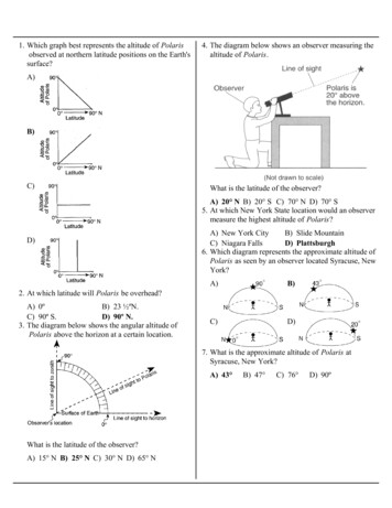
1. Which graph best represents the altitude of Polarisobserved at northern latitude positions on the Earth'ssurface?4. The diagram below shows an observer measuring thealtitude of Polaris.A)B)C)What is the latitude of the observer?A) 20 N B) 20 S C) 70 N D) 70 S5. At which New York State location would an observermeasure the highest altitude of Polaris?D)A) New York CityB) Slide MountainC) Niagara FallsD) Plattsburgh6. Which diagram represents the approximate altitude ofPolaris as seen by an observer located Syracuse, NewYork?A)B)C)D)2. At which latitude will Polaris be overhead?A) 0ºB) 23 ½ºN.C) 90º S.D) 90º N.3. The diagram below shows the angular altitude ofPolaris above the horizon at a certain location.7. What is the approximate altitude of Polaris atSyracuse, New York?A) 43 What is the latitude of the observer?A) 15 N B) 25 N C) 30 N D) 65 NB) 47 C) 76 D) 90º
8. The diagram below shows an instrument made from adrinking straw, protractor, string, and rock.11. An observer on a moving ship notices that thealtitude of Polaris increases each night. Local solarnoon occurs at the same time each day. In whatdirection is the ship moving?A) due eastB) due southC) due westD) due north12. Which graph best represents the relationshipbetween the latitude of an observer and the observedaltitude of Polaris above the northern horizon?This instrument was most likely used to measure theA) distance to a starB) altitude of a starC) mass of the EarthD) mass of the suspended weight9. As a person travels northward from the Equator, thealtitude of Polaris will appear toA) decreaseB) increaseC) remain the same10. The diagram below represents an observermeasuring the altitude of Polaris.A)B)C)D)13. At which location is the altitude of Polarisapproximately 42 ?A) Niagara FallsB) ElmiraC) WatertownD) Massena14. At which New York State location will an observermost likely measure the altitude of Polaris asapproximately 42 ?A) JamestownB) PlattsburghC) OswegoD) New York City15. If an observer on Earth views Polaris on thehorizon, the observer is located at theA)B)C)D)At which latitude is this observer located?A) 16 NC) 53 NB) 37 ND) 90 Nequator (0 )North Pole (90 N)Tropic of Cancer (23.5 N)Tropic of Capricorn (23.5 S)
16. The diagram below represents the route of a shiptraveling from New York City to Miami, Florida.Each night, a passenger on the ship observes Polaris.18. The diagram below shows an observer on Earthmeasuring the altitude of Polaris.Which statement best describes the observedchanges in the altitude of Polaris made by thepassenger during the voyage?A) Each night the altitude decreases in thenorthern sky.B) Each night the altitude decreases in thesouthern sky.C) Each night the altitude increases in the northernsky.D) Each night the altitude increases in the southernsky.17. The diagram below shows latitude measurementsevery 10 degrees and longitude measurements every15 degrees.What is the latitude and longitude of point X?A) 40 S 45 EC) 60 S 30 WB) 50 N 45 WD) 75 N 30 EWhat is the latitude of this observer?A) 90 NB) 66.5 NC) 43 ND) 23.5 N19. At which location will the highest altitude of the starPolaris be observed?A)B)C)D)EquatorTropic of CancerArctic Circlecentral New York State
Base your answers to questions 20 and 21 on the time-exposure photograph shown below. Thephotograph was taken by aiming a camera at a portion of the night sky above a New York Statelocation and leaving the camera's shutter open for a period of time to record star trails.20. Which celestial object is shown in the photograph near the center of the star trails?A) the SunB) the MoonC) SiriusD) Polaris21. During the time exposure of the photograph, the stars appear to have moved through an arc of 120º.How many hours did this time exposure take?A) 5 hB) 8 hC) 12 h22. The diagram below shows an observer on Earthmeasuring the altitude of Polaris.D) 15 h23. As a ship crosses the Prime Meridian, an observer onthe ship measures the altitude of Polaris at 60 .What is the ship's location?A)B)C)D)What is the latitude of this observer?A) 43 NC) 47 NB) 43 SD) 47 S60 south latitude and 0 longitude60 north latitude and 0 longitude0 latitude and 60 east longitude0 latitude and 60 west longitude
24. Base your answer to the following question on the world map below. Letters A through D representlocations on Earth's surface.At which location could an observer not see Polaris in the night sky at any time during the year?A) AB) BC) CD) D
25. Which statement about Polaris is best illustrated bythe diagrams shown below?26. The dashed line on the map below shows a ship'sroute from Long Island, New York, to Florida. Asthe ship travels south, the star Polaris appears lowerin the northern sky each night.The best explanation for this observation is thatPolarisA) Polaris is located in a winter constellationB) Polaris is located at the zenith at each location.C) Polaris' apparent movement through the skyfollows a south-to-north orientation.D) Polaris' altitude is equal to a locationslatitude.A)B)C)D)rises and sets at different locations each dayhas an elliptical orbit around Earthis located directly over Earth's Equatoris located directly over Earth's North Pole
27. Which diagram best shows the altitude of Polarisobserved near Buffalo, New York?A)Base your answers to questions 29 and 30 on themap below, which shows the latitude and longitudeof five observers, A, B, C, D, and E, on Earth.B)C)29. What is the altitude of Polaris (the North Star)above the northern horizon for observer A?D)A) 0 B) 10 C) 80 D) 90 30. Which two observers would be experiencing thesame apparent solar time?A) A and CB) B and CC) B and ED) D and E31. From Utica, New York, Polaris is observed at analtitude of approximately28. The North Star (Polaris) can be used for navigationin Earth's Northern Hemisphere becauseA) Polaris is located directly over the Tropic ofCancerB) Polaris is the brightest and most easily locatedstarC) the altitude of Polaris is equal to theobserver's latitudeD) the position of Polaris changes with theseasonsA) 43º B) 47º C) 75º D) 90º32. What could be the approximate location of anobserver if he measured the altitude of Polaris to be41 degrees above the horizon?A) WatertownC) BuffaloB) MassenaD) New York City
33. Base your answer to the following question on the passage and map below. The map shows sectionsof the Atlantic Ocean, the Caribbean Sea, and the Gulf of Mexico.ShipwreckIn 1641, the crew of the ship Concepcion used the Sun and stars for navigation. The crew thought thatthe ship was just north of Puerto Rico, but ocean currents had carried them off course. The ship hit acoral reef and sank off the coast of the Dominican Republic. The Xon the map marks the location ofthe sunken ship.At which map location does Polaris appear the highest in the nighttime sky?A) Miami, FloridaC) Havana, CubaB) Kingston, JamaicaD) San Juan, Puerto Rico
34. Which diagram best represents the location ofPolaris for an observer located at the Equator?37. The diagram below shows an observer on Earthviewing the star Polaris.A)B)What is the observer's latitude?A) 38 NB) 38 SC) 52 ND) 52 S38. As a person travels due west across New York State,the altitude of Polaris willC)A) decreaseB) increaseC) remain the same39. The diagram below shows the altitude of Polarisabove the horizon at a certain location.D)35. From which New York State location would Polarisbe observed to have an altitude closest to 43 abovethe northern horizon?A) BinghamtonB) UticaC) WatertownD) New York City36. As a ship crosses the Prime Meridian, the altitude ofPolaris measured from the ship is 50 . What is theship’s location?A)B)C)D)0 latitude 50 east longitude0 latitude 50 west longitude50 north latitude 0 longitude50 south latitude 0 longitudeWhat is the latitude of the observer?A) 10 NC) 50 NB) 40 ND) 90 N
40. The diagram below shows a student in New YorkState observing Polaris.The student is located nearest to which city in NewYork State?A) PlattsburghC) New York CityB) AlbanyD) Kingston
02.12.2016 · C)is located directly over Earth's Equator D)is located directly over Earth's North Pole 26.The dashed line on the map below shows a ship's route from Long Island, New York, to Florida. As the ship travels south, the star Polaris appears lower in the northern sky each night. The best explanation for this observation is that Polaris