Transcription
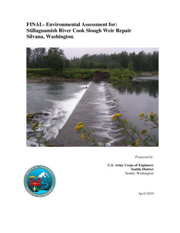
FINAL- Environmental Assessment for:Stillaguamish River Cook Slough Weir RepairSilvana, Washington.Prepared by:U.S. Army Corps of EngineersSeattle DistrictSeattle, WashingtonApril 2010
-page left intentionally blank-FINAL Environmental AssessmentStillaguamish River Cook Slough Weir Repair
Executive SummaryThis document is an environmental assessment (EA) prepared by the Seattle District,U.S. Army Corps of Engineers (USACE) for repair of an existing Stillaguamish Riverweir known as the Cook Slough weir. It is intended to satisfy public involvement anddisclosure requirements under the National Environmental Policy Act of 1969. Thedocument describes the project and its likely effects on terrestrial resources, aquaticresources, federally listed species under the Endangered Species Act and effects on thehuman environment arising from repair activities of the weir. This document will serveas the basis for the preparation of a Finding of No Significant Impact or anEnvironmental Impact Statement.The existing Cook Slough weir is located at river mile 16 on the Stillaguamish River.The weir was constructed in 1936-37 to provide gradient control to keep adequatesummer flows in both the Stillaguamish main stem and Cook Slough. The weir alsoreduces backwater during flood events and provides some fish passage.The downstream sheet pile installed during an earlier repair has failed in the vicinity ofthe low flow fish notch and in the same area the Wakefield piling cutoff wall has alsofailed. There are numerous large voids, and there is a large scour hole downstream ofthe weir. Failure of the weir would stress the bank protection system on Cook Slough. Acomplete failure of the weir would change the flow split between Cook Slough and themain channel. Significant aggradation could be expected on the main channel. Thereduction in discharge would greatly reduce the ability of the main channel to remainclear of sediment and would also greatly limit fish migration and habitat in the mainstem.Summary of ImpactsEnvironmental impacts from the proposed project include both acute and chronic changesto the baseline condition. Acute impacts are episodic and principally associated withconstruction activities during the repair. They may include increased turbidity andtemporary riparian vegetation losses due to staging and associated constructionoperations. During construction there is also a potential for stress or injury to fishassociated with altered flow patterns or encounters with temporary rock structures.Despite appropriate containment and control measures, there is always a possibility ofleaks or spills of chemicals including fuels, lubricants, adhesives, and other chemicals.During construction it is possible that the fishway efficiency may be temporarily altereddue to changing flow characteristics, nearby noise or other construction related activities.Chronic impacts are generally positive and include a reduced potential for stranding ofjuveniles due to flow manipulation caused by the weir repairs. The repaired weir andredesigned fishway will allow better attraction flows to the left bank and better reliabilityof meeting minimum instream flows.FINAL Environmental AssessmentStillaguamish River Cook Slough Weir Repair
FINAL Environmental AssessmentStillaguamish River Cook Slough Weir Repair
TABLE OF CONTENTS1. Introduction .11.1. Project Authority .11.2. Purpose and Need .11.3. Project Location .21.4. Background .42. Alternatives Evaluation. .42.1. Alternatives Evaluation .42.2. No Action Alternative .42.3. Localized Repair Alternative .52.4. Comprehensive Repair Alternative .53. Detailed Description of the Preferred Alternative .63.1. Comprehensive Weir Repair.63.1.1. Cofferdam construction .63.1.2. Fishway .73.1.3. Riprap scour protection .83.1.4. Access Road. .84. Affected Environment .94.1. Climate and Geology. .94.2. Water Quality .94.2.1. Water Temperature . 104.2.2. Turbidity and suspended sediments . 104.2.3. Chemistry . 104.3. Hydraulics and Hydrology . 104.4. Vegetation . 114.5. Wetlands. 114.6. Aquatic Resources . 114.7. Terrestrial Resources . 124.8. Cultural Resources . 134.9. Federally Endangered and Threatened Species . 134.10. Noise and Air Quality . 144.11. Demographics and Socioeconomics . 145. Environmental Effects of the Proposed Project . 145.1. Climate and Geology . 145.1.1. Sediments . 155.2. Water Quality . 155.2.1. General . 155.2.2. Temperature. . 15FINAL Environmental AssessmentRepair Stillaguamish River Cook Slough Weiri
5.2.3. Turbidity and Suspended Sediments . 155.2.4. Chemistry . 165.2.5. Land Use and Potential Pollution Sources . 165.3. Hydraulics And Hydrology . 175.4. Vegetation . 175.5. Wetlands. 175.6. Aquatic Resources . 175.6.1. Fish Resources . 175.7. Terrestrial Resources . 185.8. Federally Threatened And Endangered Species . 185.8.1. Chinook Salmon . 185.8.2. Bull Trout. 195.8.3. Steelhead . 205.8.4. Marbled Murrelet . 215.9. Archaeological And Historical Cultural Resources. 225.10. Noise and Air Quality . 226. Environmental Effects of the No Action Alternative . 237. Cumulative Effects. 247.1. Corps Stillaguamish River Bank Protection Project. . 248. Treaty Rights . 259. Environmental Compliance . 259.1. National Environmental Policy Act . 259.2. Endangered Species Act . 259.3. Clean Water Act Compliance. 269.4. Fish and Wildlife Coordination Act . 269.5. Essential Fish Habitat . 269.6. National Historic Preservation Act . 269.7. Clean Air Act. 279.8. Environmental Justice . 279.9. Coastal Zone Management Act . 2710. Conclusions . 2811. References. 29LIST OF FIGURESFigure 1-1. Vicinity Map.Figure 1-2. View of weir showing sheet pile failure.Figure 1-3. Cook Slough weir showing the new fishway design, and scour protectionriprap blanket placement.FINAL Environmental AssessmentRepair Stillaguamish River Cook Slough Weirii
APPENDICESAPPENDIX A. SUBSTANTIVE COMPLIANCE FOR SECTION 404 OF THECLEAN WATER ACT AND THE RIVERS AND HARBORS ACTAPPENDIX B. REQUIRED STATE AND FEDERAL AGENCY RESPONSESAPPENDIX C. PROJECT CORRESPONDENCEFINAL Environmental AssessmentRepair Stillaguamish River Cook Slough Weiriii
page left intentionally blankFINAL Environmental AssessmentRepair Stillaguamish River Cook Slough Weiriv
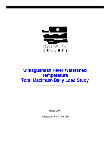
1. Intr oductionThis document is an environmental assessment (EA) prepared by the Seattle District,U.S. Army Corps of Engineers (Corps) for repair of an existing weir located on theStillaguamish River at river mile (RM) 16 currently known as the Cook Slough weir(CSW). The repair does not alter the existing weir design except to provide enhancedfish passage by redesigning the boulder fishway to function properly at low flows. TheEA is intended to provide for public disclosure of project components and impacts to theenvironment required by the National Environmental Policy Act of 1969 for all FederalActions.1.1. Project AuthorityThe Stillaguamish River Flood Control Project was originally authorized by the FloodControl Act of 22 June 1936. Cook Slough weir was one of the flood control projectsauthorized under this act. The Flood Control Act of 28 June 1938 provides for Federalmaintenance of the project.1.2. Purpose and NeedThe Cook Slough weir repair project consists of needed repairs to the existing structure inorder to avoid total structure failure. The project also includes the construction of aboulder channel fishway to provide better fish passage during low flow events.The purpose of the Cook Slough weir is to provide gradient control in order to keepadequate summer flows in both the Stillaguamish main stem and Cook Slough(sometimes referred to as Koch Slough). The weir also reduces backwater during floodevents and provides some fish passage. A fishway was incorporated into the weir in1988, on the left (south) bank of the river. The existing fishway is a simple baffle systemthat does not have adequate attraction flows and may contribute to fish stranding at lowflow events (NMFS personal communication). The downstream sheet pile installedduring an earlier repair has failed in the vicinity of the low flow fish notch and in thesame area the Wakefield piling cutoff wall has also failed (Figure 1-1). There arenumerous large voids with some extending upstream almost to the second row of timberpiling and there is a large scour hole downstream of the weir. This scour hole tends tohold fish, and may act to distract fish away from the current fishway. This can lead tostranding and mortality, especially during low flow and high temperature events.Failure of the weir would stress the bank protection system on Cook Slough. A completefailure of the weir would change the flow split between Cook Slough and the mainchannel. Significant aggradation could be expected on the main channel. The reductionin discharge would greatly reduce the ability of the main channel to remain clear ofsediment and would also greatly limit fish migration and habitat in the main stem.FINAL Environmental AssessmentRepair Stillaguamish River Cook Slough Weir1
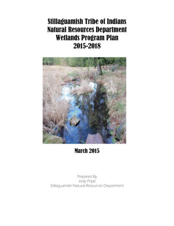
Figure 1-1. View of weir showing sheet pile failure.1.3. Project LocationThe Cook Slough weir is located near the city of Silvana, Washington on theStillaguamish River at the upstream end of Cook Slough, in T31N, R5E, Sec. 6 SW ¼(Figure 1-2). The project is located at RM 16 on the Stillaguamish River, inunincorporated Snohomish County. Adjacent lands include privately owned farms andtribal lands.FINAL Environmental AssessmentRepair Stillaguamish River Cook Slough Weir2
Figure 1-2. Project vicinity Map.FINAL Environmental AssessmentRepair Stillaguamish River Cook Slough Weir3
1.4. BackgroundThe construction of the Cook Slough weir was completed in 1937 to provide floodcontrol for the town of Stanwood, Washington. A repair to the facility was performed in1984 and a fish passage system was constructed in 1988 and 1989. The originalconstruction consisted of a reinforced concrete weir with ogee crest supported by timberpiling and Wakefield piling timber cutoff wall between steel sheet pile cell abutments.The repair performed in 1984 corrected some structural deficiencies and installed a notchin the weir for fish passage at low flows. Part of the ogee concrete was removed andreplaced, steel sheet piling was installed along the upstream and downstream faces of theweir, an ‘L’ shaped angle connected the top of the piling to the concrete slab, and somevoids under the slab were filled with grout. In 1988 a fish passage baffle system(fishway) was constructed at the south abutment with some enhancements to it performedin 1989.The Stillaguamish River Basin is the fifth largest tributary to Puget Sound encompassingan area of approximately 684 square miles with more than 975 miles of rivers andtributaries (USACE, 2000). Two large forks, the North and South Forks, converge into amain stem near Arlington, WA and eventually branch into the main channel and sloughsbefore the river empties into Puget Sound. Near Arlington, the river meanders westward23 miles through a fertile flood plain, where most of the basin’s agricultural land islocated. Near Silvana, the channel divides into Cook Slough and the main stem riverchannel. The river divides again approximately eight miles from the mouth, into HatSlough where the primary flow is concentrated in the river channel. The river channelbelow Hat Slough is extensively shoaled and carries little or no flow during the dryseason. Since the 1860’s, several private and public entities have constructed small floodcontrol levees and dredged channels for purposes of both flood control, gravel mining,and for converting wetlands to agriculture lands. The watershed includes land governedby Snohomish County and Skagit County, the cities of Arlington, Stanwood, and GraniteFalls, and the Stillaguamish and Tulalip Tribes.2. Alter natives Evaluation.2.1. Alternatives EvaluationThe following section describes the alternatives considered for the project including theno action alternative. Rationale is presented for eliminating an alternative or consideringit in greater detail.2.2. No Action AlternativeThe No action alternative includes no direct action to repair any portion of the existingCook Slough weir by the Corps. This alternative does nothing to prevent continueddeterioration of the weir or solve any problems associated with failure of the weir. Thecurrent maintenance efforts consisting primarily of removal of backed up debris wouldcontinue. The fishway would remain in its current configuration.FINAL Environmental AssessmentRepair Stillaguamish River Cook Slough Weir4
Conclusions:The no action alternative essentially allows the weir to further deteriorate, eventually tocomplete structural failure. Failure of the grade control weir would stress the bankprotection system on the Cook Slough. This alternative would not improve the fishwayor adequately address the scour hole. This could lead to further fish strandings andtemperature induced mortalities. A complete failure of the weir would change the flowsplit between Cook Slough and the main channel. Significant aggradation could beexpected on the main channel. The reduction in discharge would greatly reduce theability of the main channel to remain clear of sediment and would also greatly limit fishmigration and habitat in the main stem.2.3. Localized Repair AlternativeThis alternative would only provide needed repairs to the existing structure to restore theweir to pre-damage conditions. Structural repairs needed in order to keep the weirfunctioning as in the past would be accomplished (sheet pile replacement, and the fillingof voids). The repairs recommended in this alternative would correct the currentstructural deficiencies which are jeopardizing the structural integrity of the weir, but are arelatively short term repair solution. The estimated life of repairs for this localized repairalternative is 10 to 15 years. This alternative would not change the current fishway inanyway or fill the scour hole below the weir.Conclusions:This alternative would meet at least a portion of the purpose and need of the project bykeeping the weir functioning as originally designed/authorized. This would however,miss an opportunity to improve the fish passage situation at the weir, and would notincorporate any benefits to the native salmon populations of the Stillaguamish River. Forthese primary reasons, the Localized Repair Alternative was rejected and dropped fromfurther analysis2.4. Comprehensive Repair AlternativeThis alternative would perform all structural repairs to the weir as well as improve theexisting fishway in order to enhance fish passage.Conclusions:This alternative would meet the purpose and need of the project by keeping the weirfunctioning as originally designed/authorized, as well as use the opportunity to greatlyimprove fish passage at the site. The Cook Slough weir has been deteriorating over timeand is continuing to deteriorate. Repair options range from short term to longer termfixes, but repair of the weir is necessary to prevent ultimate failure of the weir. Theconsequences of complete failure are significant and costly, and would be complicated tofix. Based on the analysis of the current weir condition, the recommended alternative isthe Comprehensive Repair Alternative. A comprehensive repair of the weir will costmore than the repairs recommended in the Localized Repair Alternative, but will providea longer weir repair lifespan (50 years) and prevent significant changes to thegeomorphology of the area (avoids the aggradation of the mainstem). This alternativeFINAL Environmental AssessmentRepair Stillaguamish River Cook Slough Weir5
was identified early in the planning process and addresses structural needs of the weir aswell as fish passage. This represents the best sustainable mix of federal interests that areconsistent with federal fish passage responsibilities. For this reason, this alternative isconsidered the preferred alternative and the impacts of this alternative will be presentedthroughout the remainder of this document. A detailed description of this alternative isprovided in Section 3.3. Detailed Descr iption of the Pr efer r ed Alter native3.1. Comprehensive Weir RepairThe proposed project includes a structural repair of the weir to fix its currentdamaged/deteriorated condition. Construction is currently planned for the Summer of2010, and will run from approximately 15 July to 31 October 2010. The starting date isdependent on the flow and river stage, as the repair work will require low flowconditions.The project proposes to replace approximately 200 linear feet of steel sheet piling, andrepair all deteriorated concrete areas. The existing scour hole on the downstream side ofthe weir will be filled with rock riprap in order to provide adequate scour protection. Theexisting fishway structure will be modified to enhance fish passage, and the existing lowflow notch will be permanently removed. Temporary access roads will be constructed.Stabilization of the sand/gravel bar will be necessary to support heavy equipment. Theproject also requires the temporary construction of a cofferdam upstream of the weir topartially dewater the weir structure for equipment access and to effect repairs. Allstabilization materials will be removed and disturbed areas will be restored at projectcompletion.The construction sequence will be essentially as follows: construct upstream berm toisolate the fishway, divert flow over the weir, re-work fishway, remove fishway berm,construct berm to isolate the weir face and scour hole, divert flow through the fishway,remove damaged sheet pile, drive new sheet pile, fill voids, redo sill, remove dewateringberm, restore site.3.1.1. Cofferdam constructionA cofferdam berm will be used to partially dewater the construction site. Water will firstbe diverted over the weir to effect the boulder channel fishway construction and thenthrough the fishway to effect weir structural repairs. This two phase approach todewatering will ensure that a minimum flow will be maintained downstream of the weirin Cook Slough throughout the project duration. Dewatering will hydraulically isolatethe fishway, weir and scour hole repair areas from the river during construction activitiesand effectively control all discharges and downstream turbidity. Construction of thecofferdam is planned for July during a period of naturally high turbidity, low flows andwithin established in-water work windows (currently July 15 – August 31) as much aspossible.FINAL Environmental AssessmentRepair Stillaguamish River Cook Slough Weir6
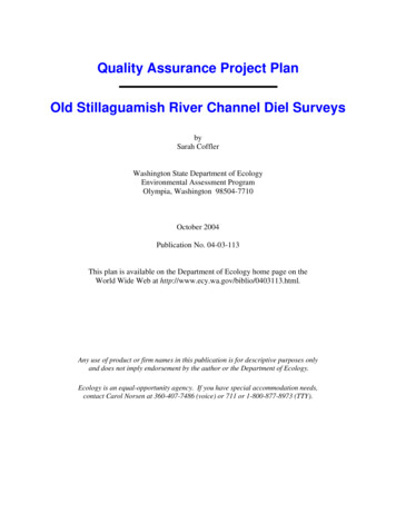
3.1.2. FishwayImprovements to the left bank fishway will be designed to eliminate fish stranding and toprovide enhanced passage during low flow events (Figure 1-3). The existing fishway,essentially a baffle structure, was added to the weir in 1988, and was a minimallyengineered, quick solution to low flow fish strandings. The new design provides agraduated boulder channel ( 4% slope), with multiple plunge pools to bring fish up to thecurrent baffle system and allow passage. Additionally the permanent elimination of thelow flow notch will increase attractant flow through the fishway structure, especiallyduring low flow events. The boulder channel fishway re-work portion of this project willbe accomplished early in the project in order to avoid threatened or endangered fishmigrations and/or spawning periods as much as possible. The fish passage structure maybe required to be at least partially dewatered during this portion of the repair. However,minimum flows into Cook Slough will be maintained. The work may continue outside ofthe fish window, but all work would be completed by 31 October in order to avoid thelate season high flows. In all cases, appropriate measures will be taken to controldownstream turbidity caused by the project.Figure 1-3. Cook Slough weir showing the new fishway design, and scour protectionriprap blanket placement.FINAL Environmental AssessmentRepair Stillaguamish River Cook Slough Weir7
3.1.3. Riprap scour protectionThe downstream scour hole will be filled with approximately 1,400 square feet of class IIriprap (16 inch diameter rock) tapered from approximately 3 -8 feet in depth. The riprapblanket will be sloped up toward the downstream sheet pile side of the weir wall toprovide extra structural stability. Filling in the scour hole will eliminate the distractingeffect of the deep plunge pool and should reduce fish strandings by focusing fish on there-worked fishway. This work would be accomplished behind the cofferdam and in thedry.3.1.4. Access Road.An existing right bank gravel road will be used for primary site access. Heavy equipmentaccess to the weir face and fishway areas will be via existing right bank gravel bar andinside of the cofferdam berm. Some additional stabilization will be provided at thegravel bar and access road. Left bank access, if needed, would be via existing gravelroad. These areas will be restored to pre-project conditions upon project completion asmuch as possible.The Corps utilizes the below best management practices (BMPs) when applicable, aswell as recommendations received from US Fish and Wildlife Service, National MarineFisheries Service, and the State of Washington Department of Ecology to minimizeproject impacts:General Equipment that will be used near the water will be cleaned prior to construction Work will be conducted during a period of low flow Refueling will occur at least 500 feet away from the river bank Construction equipment will be regularly checked for drips or leaks At least one fuel spill kit with absorbent pads will be onsite at all timesSediment Control The Construction Supervisor is responsible for implementing whatever turbiditycontrol measures are needed to ensure the turbidity mixing zone does not exceedthe standards contained in Water Quality Standards for Surface Waters of theState of Washington (173-201A WAC) Turbidity will be periodically monitored Equipment that will be used near the water will be cleaned prior to construction Continuous visual inspections will be made by the Construction Supervisor toensure compliance If the mixing zone exceeds the 173-201A WAC standards, the ConstructionSupervisor will modify construction methodologies in order to meet the standards If the 173-201A WAC standards cannot be maintained, the ConstructionSupervisor will halt the construction activities causing the discharge until analternative plan can be developed in conjunction with the Corps and/or agencies The use of silt fencing or other sediment control devices will be implemented asrequired by the design. As site conditions change (i.e. rain) implementation ofother devices may be necessary.FINAL Environmental AssessmentRepair Stillaguamish River Cook Slough Weir8
4. Affected Envir onment4.1. Climate and Geology.The Stillaguamish Basin’s climate is typically maritime, with cool wet winters and mildsummers. Average rainfall ranges from 30 inches in the western lowlands to over 140inches in the forested eastern region. Approximately 75% of the basin’s precipitationfalls between October and March. At elevations greater than 3000 feet, much of thisprecipitation falls as snow. Major winter and spring flooding can occur when abruptwarming results in rain-on-snow events. Spring snowmelt runoff generally peaks in May.The lowest stream flows occur during dry summer months, typically July throughSeptember.The Stillaguamish Basin, like other river basins arising in the Cascade Range along PugetSound, has been shaped by a number of geologic processes and events. The two majorgeologic processes along the Pacific Northwest Coast are the movement of tectonicplates, which is manifested by seismic activity and volcanism, and glaciation. TheCascade Mountain Range is the result of several periods of tectonic uplift and volcaniceruptions. High volcanic peaks such as Mount Rainier, Mount St. Helens, and MountBaker continue to build in modern times (Kruckeberg 1991). Throughout much of theQuaternary Period, the basin underwent continental glaciation. The ice was typicallyseveral thousand feet thick and caused tremendous scouring and compaction of
The existing Cook Slough weir is located at river mile 16 on the Stillaguamish River. The weir was constructed in 1936-37 to provide gradient control to keep adequate summer flows in both the Stillaguamish main stem and Cook Slough. The weir also reduces backwater during flood events and provides some fish passage.