Transcription
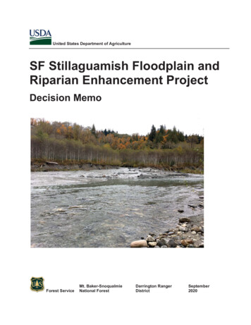
United States Department of AgricultureSF Stillaguamish Floodplain andRiparian Enhancement ProjectDecision MemoForest ServiceMt. Baker-SnoqualmieNational ForestDarrington RangerDistrictSeptember2020
Responsible Official:Gretchen SmithDistrict RangerDarrington Ranger DistrictFor Information Contact:Richard VacircaForest Watershed and Fisheries Program ManagerMt. Baker-Snoqualmie National Forest2930 Wetmore Ave, Everett, WA 98201richard.vacirca@usda.govIn accordance with Federal civil rights law and U.S. Department of Agriculture (USDA) civil rights regulations and policies,the USDA, its Agencies, offices, and employees, and institutions participating in or administering USDA programs areprohibited from discriminating based on race, color, national origin, religion, sex, gender identity (including genderexpression), sexual orientation, disability, age, marital status, family/parental status, income derived from a public assistanceprogram, political beliefs, or reprisal or retaliation for prior civil rights activity, in any program or activity conducted orfunded by USDA (not all bases apply to all programs). Remedies and complaint filing deadlines vary by program or incident.Persons with disabilities who require alternative means of communication for program information (e.g., Braille, large print,audiotape, American Sign Language, etc.) should contact the responsible Agency or USDA’s TARGET Center at (202) 7202600 (voice and TTY) or contact USDA through the Federal Relay Service at (800) 877-8339. Additionally, programinformation may be made available in languages other than English.To file a program discrimination complaint, complete the USDA Program Discrimination Complaint Form, AD-3027, foundonline at http://www.ascr.usda.gov/complaint filing cust.html and at any USDA office or write a letter addressed to USDAand provide in the letter all of the information requested in the form. To request a copy of the complaint form, call (866) 6329992. Submit your completed form or letter to USDA by:(1) mail: U.S. Department of AgricultureOffice of the Assistant Secretary for Civil Rights 1400 Independence Avenue, SWWashington, D.C. 20250-9410;(2) fax: (202) 690-7442; or(3) email: program.intake@usda.gov.USDA is an equal opportunity provider, employer, and lender.
Decision MemoContents1.2.3.4.5.6.7.8.9.Decision .11.1. Project Location.11.2. Need for the Project .11.3. Project Description .1Design Features .22.1.1.Botany Resources .22.1.2.Watershed, Soils and Fisheries Resources .32.1.3.Wildlife Resources .32.1.4.Recreation and Visual Quality .32.1.5.Heritage Resources .3Tribal Consultation .4Public Involvement.4Extraordinary Circumstances Review .4Reason for Categorically Excluding this Project .7Findings Required By Other Laws .7Administrative Review or Appeal Opportunities .11Implementation .12List of FiguresFigure 1. SF Stillaguamish Floodplain and Riparian Enhancement Project Area Map. .13Figure 2. Landslide deposit at the base of lobe 2 of the Gold Basin Slide and in the SF StillaguamishRiver. .14Figure 3. Sediment deposited by the Gold Basin Slide is visible in the river adjacent to and downstreamfrom the slide. .14Figure 4. Gold Basin Campground campsite adjacent to the S.F. Stillaguamish River. .15Figure 5. Remnant side channel that runs through a portion of the Gold Basin Campground. .15Figure 6. Eroding bank below a campsite within the Gold Basin Campground. The river reroute will start(upstream extent) through this portion of the campground. .16i
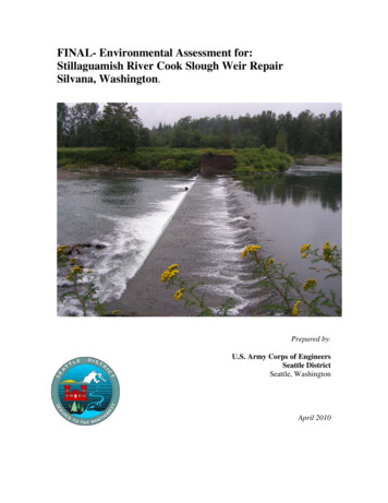
Decision Memo1. DecisionIt is my decision to implement the South Fork (SF) Stillaguamish Floodplain and RiparianEnhancement Project. The project will decommission a portion of the Gold Basin Campground torestore SF Stillaguamish River floodplain processes and improve water quality. The project isdescribed below in section 1.3.I have decided to implement the project because it meets the need identified in section 1.2. Indeciding to implement this project, I considered comments received during scoping and the projectrecord (including botany, wildlife, fisheries and heritage specialist reports which are incorporated byreference in this decision). I also considered the 2018 Environmental Assessment and Draft DecisionNotice and Finding of No Significant Impact for the Gold Basin Habitat Restoration Project. Note:after considerable review and coordination with Washington State agencies, the 2018 Gold BasinHabitat Restoration Project was cancelled but that analysis nevertheless informed the design of thisproject and analysis of potential effects.Scoping for the proposed action was initiated in November 2019. Modifications were then made tothe proposed action based feedback received during scoping (see section 4) as well asinterdisciplinary review of the project. These changes are reflected in the project description (seesection 1.3) and associated design features (section 2) described below.This Decision Memo documents my decision to proceed with the project, consistent withrequirements in the National Environmental Policy Act and related regulations. See section 6 belowdocumenting my rationale for excluding this project from further documentation in anEnvironmental Assessment or Environmental Impact Statement.1.1. Project LocationThe project occurs at river mile (RM) 48, 15 miles east of the town of Granite Falls, WA at GoldBasin Campground (CG). The campground is approximately 2.5 miles east of Verlot, Washington,and is situated between the Mountain Loop Highway and SF Stillaguamish River within Township30 N, Range 8 E, Sections 13-14, 23-24; Snohomish County, Washington. Please see figure 1 foradditional location information.1.2. Need for the ProjectThere is a need to enhance fish habitat within the SF Stillaguamish River to help increaseanadromous fish abundance and productivity and contribute to the recovery of Federally listedspecies, such as chinook salmon. To accomplish this need, the project intends to increase fishspawning and rearing success by reclaiming a portion of historic floodplain (see figures 4-6),enhancing aquatic habitat function and complexity and improving riparian vegetation structure,which will lead to improved water quality conditions. See January 17, 2020 Aquatic ResourceEffects Biological Evaluation (BE) for additional information about the purpose and need for theproject.1.3. Project DescriptionThe SF Stillaguamish Floodplain and Riparian Enhancement Project will decommission a closedportion of the Gold Basin Campground to restore floodplain processes. Some of the campsites andrelated infrastructure adjacent to the river will be removed (see figure 1) and a section of the river
SF Stillaguamish Floodplain and Riparian Enhancement Projectchannel will be reconstructed through the decommissioned portion of campground (see figures 2-4).Additional project elements will include grading of the floodplain in the channel’s former location(see figure 5), tree tipping, installation of large wood structures to provide bank stability and aquatichabitat complexity, strategic placement of other large trees to provide for channel and floodplainstability, and riparian vegetation planting where appropriate. Trees tipped will be left on site andincorporated into large wood structure installation where possible.The entire Gold Basin Campground will be closed to the public during construction andrehabilitation of disturbed areas. Much of the upland and in-water work performed by heavyequipment is anticipated to occur between March and September 2021 although tree tipping wouldbe completed outside of the marbled murrelet nesting season (tree tipping could occur fromSeptember 24, 2020 to March 31, 2021). Upon completion of construction, the remaining portion ofthe campground would then be re-opened for public use.The actions described above will be implemented under a short-term special use authorization issuedto the Stillaguamish Tribe.The project will allow for fluvial and potential future landslide processes to take place whilebalancing the need to enhance localized water quality conditions by allowing new floodplain andriparian vegetation surfaces to act as filters to turbid water sourced from the landslide. Hence, alongthis reach of the SF Stillaguamish River the project is expected to provide conditions moreconducive for spawning and habitat complexity by re-setting adjacent geomorphic and vegetativefeatures.2. Design FeaturesThe following management requirements, project design criteria (PDC) and mitigation measures areintegral components of this decision and will be adhered to and incorporated into the implementationof this project.2.1.1.Botany ResourcesThreatened, Endangered, Sensitive (TES) or Survey and Manage (S&M) SpeciesxIf any previously undiscovered TES or other rare or uncommon vascular plants, bryophytes,lichens, or fungi are discovered, before or during project implementation, halt work until aUSFS botanist is consulted and necessary mitigation measures are enacted.Noxious Weeds2xTreat known infestations before ground disturbance begins. To be effective a lag time of 4weeks is needed between the time of treatment and the time of ground disturbance.xFor actions conducted or authorized by written permit by the Forest Service that will operateoutside the limits of the road prism, require the cleaning of all heavy equipment prior toentering National Forest System Lands.xSuppliers must provide documentation indicating that the following products have beenexamined by a qualified inspector and deemed free of State listed noxious weeds: Straw or other Mulch Gravel, Rock, or other fill
Decision Memo Seeds (according to Association of Official Seed Analyst standards)xIf weeds are present in the project area, all equipment and gear must be cleaned beforeleaving the project area to avoid spreading the infestation further.xIf weeds are present in the project area, work from relatively weed-free areas into theinfested area rather than vice versa.xRevegetate all areas of bare soil exposed by project activities if there is a risk of noxiousweed invasion. Native plant materials are the first choice in revegetation where timelynatural regeneration of the native plant community is not likely to occur. If native plantmaterials are not available, use the appropriate MBS non-native seedmix (per Potash andAubry 1997).2.1.2.x2.1.3.Watershed, Soils and Fisheries ResourcesSee PDC’s in the 2015 Aquatic Restoration Biological Opinion (ARBO II) for activity typechannel reconstruction. 2013 Programmatic ESA consultation Aquatic RestorationBiological Opinions (ARBO II) from US Fish and Wildlife Service and US DOC NationalMarine Fisheries Service under the activity for Fish Passage Restoration. NMFS NWP-20139664; FWS OIEOFW00-20 I 3-F-0090.Wildlife ResourcesxProhibit garbage or trash from being left in the project area.xHeavy equipment and other activities generating noise above ambient levels, and occurringfrom April 1 through September 5 would occur between two hours after sunrise to two hoursbefore sunset.xProject will be consistent with conservation measures outlined in MBS Forest ProgrammaticBO (FWS Reference Number 1-3-02-F-1583, pp. 32-35) and summarized in the “SF StillyRestoration BA Documents” document included in the project record.2.1.4.x2.1.5.Recreation and Visual QualityAppropriate public safety measures will be in place during construction.Heritage ResourcesxConduct cultural resource surveys prior to implementing ground-disturbing activities.xComplete section 106 compliance prior to project implementation.xUntil proper evaluation occurs, all known cultural resource properties shall be protectedxIf a previously unidentified cultural resource is discovered during project implementation,the activity shall be stopped in the area of the find and a reasonable effort to secure andprotect the resource be made. The Heritage Specialist shall be notified, and the Forest wouldfulfill its responsibilities in accordance with the Programmatic Agreement and otherapplicable regulations.xIf human remains are discovered, all work must stop in the area of the discovery and NativeAmerican Graves Protection and Repatriation Act protocols followed.
SF Stillaguamish Floodplain and Riparian Enhancement Project3. Tribal ConsultationI notified the Stillaguamish, Tulalip, and Sauk-Suiattle Tribes of the proposed project by mail. TheTulalip Tribes responded with a letter supporting the proposed action and acknowledging that theproject would improve habitat factors known to limit Chinook salmon production in theStillaguamish watershed. The Sauk-Suiattle Indian Tribe responded with confirmation of theirinterest in participating as a consulting party with respect to historic and cultural resources andrequesting copies of archaeological surveys and reviews for the project. The Squaxin Island TribeCultural Resources Department confirmed by email that the project is outside the Squaxin IslandTribe’s traditional area and no further consultation with them is needed.4. Public InvolvementI emailed project notification letters to the Forest-wide mailing list (1,374 recipients) on November7, 2019. Four comments were received in response to this notification. Two of the commentsrequested additional information about the project. One of the comments expressed support for theproposal and requested that the effects of not taking action be considered. One comment from theCity of Arlington Public Works Department also expressed strong support for the sediment reductionobjectives of the project and asked that the project be reviewed by experts in fluvial geomorphology,that standard Best Management Practices be implemented, that monitoring and adaptive managementallow for additional site stabilization measures for up to three years following construction and thatthe City be kept informed during project implementation.5. Extraordinary Circumstances ReviewForest Service Handbook (FSH) 1090 15, Section 31.2 (36 CFR 220.6) identifies the followingresource conditions that should be considered in determining whether extraordinary circumstancesrelated to a proposed action warrant further analysis and documentation in an EIS or EA. Aninterdisciplinary team reviewed the proposed project and analyzed the potential for effects fromproject activities. Site-specific conditions were reviewed in the field, and office-records weresearched to determine if the potential effects on resources would result in any extraordinarycircumstances. The mere presence of a “resource condition” does not preclude use of a categoricalexclusion. Rather, “it is the existence of a cause-effect relationship between a proposed action andthe potential effect on these resource conditions, and if such a relationship exists, the degree of thepotential effect of a proposed action on these resource conditions that determines whetherextraordinary circumstances exist” (36 CFR 220.6 (b) (2)).a) Federally listed threatened or endangered species or designated critical habitat, speciesproposed for Federal listing or proposed critical habitat, or Forest Service sensitivespeciesThe project was analyzed to determine effects on federally listed threatened or endangered species(TES), designated critical habitat, species proposed for federal listing or proposed or designatedcritical habitat, Forest Service Sensitive species known or suspected of occurring on the Forest, andForest Management Indicator species.Wildlife:Federally listed Threatened and Endangered (TE) SpeciesProject activities would have no effect on the grizzly bear and gray wolf due to high human presencein the area. Project activities are likely to adversely affect northern spotted owl, marbled murrelet4
Decision Memoand their designated critical habitats due to habitat removal and noise disturbance from the stagingand construction activities associated with project implementation. See January 2020 BE/BADocumentation and Wildlife Specialist Report, Biological Assessment and Project ConsistencyEvaluation Form in project record.SpeciesStatusPreferred HabitatSuitableHabitat inthe ProjectAreaGray wolf(Canis lupus)Endangered/MIS**Security habitat 300 m fromroad, ungulate prey baseNoNo EffectMarbled murrelet(Brachyramphusmarmoratus m.)ThreatenedMature, old-growth forests(nesting, roosting)YesLAAMarbled murreletCritical HabitatDesignatedMature conifer trees withnesting platforms and treeswithin ½ mileYesLAANorthern spotted owl(Strix occidentaliscaurina)Threatened/MISMature, old-growth forests(nesting, roosting, foraging);second-growth used fordispersalYesLAANorthern spotted owlCritical HabitatDesignatedConifer forest providingnesting, roosting, foraging, anddispersal habitatYesLAAGrizzly bear (Ursusarctos horribilis)Threatened/MISSecurity habitat 300 m fromroadNoNo Effect*Determinationfor ProposedAction* NE No effect; NLAA May affect but is not likely to adversely affect; LAA May affect and is likely to adversely affect thespecies or its designated critical habitat.**MIS Management Indicator SpeciesForest Service Region 6 Sensitive SpeciesThere is no suitable habitat or known sites for the bald eagle, common loon, Larch Mountainsalamander, Van Dyke’s salamander, mountain goat, wolverine, giant Palouse earthworm, Melissaarctic, valley silverspot, and Cascade fox in or adjacent to the project area that could be impacted bythe project. Consequently, no effect will occur to these species.The Harlequin duck, goshawk, Townsend’s big-eared bat, Puget Oregonian, broadwhorl tightcoil,shiny tightcoil, Beller’s ground beetle, western bumblebee, Suckley cuckoo bumblebee, Johnson’shairstreak, and little brown myotis are not known to occur in the project area but may be present dueto presence of potentially suitable habitat. Project activities affecting habitat and creating disturbancedue to noise and human presence may impact individuals but are not likely to create a trend towardsfederal listing.Fisheries:Threatened, Endangered, and Sensitive Species for the Mt. Baker-Snoqualmie National Forest (MBSNF), and effect determinations for project level analysis for the proposed SF Stillaguamish Riparianand Floodplain Enhancement Project are summarized in the table below. There are no designatedRegional Foresters Sensitive Species on the MBS NF.
SF Stillaguamish Floodplain and Riparian Enhancement ProjectSpeciesStatusKnown toOccur in theProject AreaSuitableHabitat in theProject Area*Determinationfor ProposedActionPuget Sound Chinook Salmon(Oncorhynchus tshawytscha)ThreatenedYesYesLAAPuget Sound Steelhead Trout(Oncorhynchus mykiss)ThreatenedYesYesLAABull Trout (Salvelinusconfluentus)ThreatenedYesYesLAA* NE No effect; NLAA May affect but is not likely to adversely affect; LAA May affect and is likely to adversely affect thespecies or its designated critical habitat.In addition, the project may affect and is likely to adversely affect the species and its designatedcritical habitat for chinook salmon, steelhead trout and bull trout. Formal ESA consultation willfollow ARBO II procedures and design criteria. The project will adversely affect coho salmon, pinksalmon and chinook salmon Essential Fish Habitat (EFH). All adverse effects are result of projectconstruction elements: dewatering, fish salvage and sediment turbidity. All effects from this projectare covered in ARBO II.Botany: No federally listed threatened, endangered, or proposed species are known to occur withinthe MBS. There are three species on the Regional Forester’s Sensitive Plant List (dated February 25,2019) for the Pacific Northwest Region, with potential suitable habitat in the project area: Leptogiumcyanescens, Bartramiopsis lescurii, and Ramalina thrausta. These three species are not known tooccur in the project area but may be present due to potentially suitable habitat. Project activitiesaffecting habitat may impact individuals but are not likely to create a trend towards federal listing.See January 2020 Botany Specialist Report.b) Flood plains, wetlands, or municipal watershedsProject will not further change nor will it degrade watershed scale features necessary to conserve andprotect elements of aquatic ecosystems. Project will restore riparian and floodplain processes byreclaiming the area currently encroached upon by the campground. Project will maintain existingspatial and temporal connectivity in the watersheds. The project will maintain water quality withinthe localized range by providing for stream bank and floodplain stability (instream structural andriparian planting components). This will also occur during construction via BMPs and other relatedpractices. See January 17, 2020 Aquatic Resource Effects Biological Evaluation.c) Congressionally designated areas, such as wilderness, wilderness study areas, ornational recreation areasThe project does not occur in any Congressionally designated area.d) Inventoried roadless areas or potential wilderness areasThe project does not occur in an Inventoried Roadless Area.e) Research Natural AreasThe project is not situated in or near a Research Natural Area.f) American Indians and Alaska native religious or cultural sitesThe project will not adversely affect any known American Indian religious or cultural sacred sites.The Federal government has trust responsibilities to Tribes under a government-to-government6
Decision Memorelationship to ensure that the Tribes’ reserved rights are protected. Consultation with Tribes helpsensure that these trust responsibilities are met. See section 3 regarding communication with Tribes.g) Archaeological sites or historic properties or areasNo previously recorded historic properties are present in the vicinity of the project and no historicproperties, structures, archaeological sites or isolated artifacts, cultural materials orculturally modified trees were identified during the inventory for the project.6. Reason for Categorically Excluding this ProjectBased on a review of the expected impacts and consultation with District and Forest resourcespecialists, I have determined that this project is categorically excluded from further analysis anddocumentation in an environmental impact statement (EIS) or an environmental assessment (EA)because there are no extraordinary circumstances related to the proposed action and the action iswithin a category identified by regulation. 36 CFR 220.6(a).xBased on a review of the potential effects of the project on resource conditions identified insection 4, there are no extraordinary circumstances that might cause this action to have asignificant effect on the quality of the human environment, individually or cumulatively.xThe category for this action is 36 CFR 220.6(e)(18): Restoring wetlands, streams, riparianareas or other water bodies by removing, replacing, or modifying water control structuressuch as, but not limited to, dams, levees, dikes, ditches, culvers, pipes, drainage tiles, valves,gates, and fencing, to allow waters to flow into natural channels and floodplains and restorenatural flow regimes to the extent practicable where valid existing rights or special useauthorizations are not unilaterally altered or cancelled.7. Findings Required By Other LawsThis decision is consistent with the 1990 Mt. Baker-Snoqualmie National Forest Land and ResourceManagement Plan as amended by the April 13, 1994 Record of Decision for Management of Habitatfor Late Successional and Old-Growth Forest Related Species Within the Range of the NorthernSpotted Owl. An extraordinary circumstances review documented that the project will comply withother applicable laws or regulations.National Forest Management Act of 1976: As required by 36 CFR 219.8(e), this decision isconsistent with the Mt. Baker-Snoqualmie National Forest Land and Resource Management Plan, asamended. See paragraphs below regarding consistency with the Forest Plan.Management direction for the proposed project is provided by the 1990 Record of Decision for theMt. Baker-Snoqualmie Land and Resource Management Plan “Forest Plan,” as amended.Amendments to the Forest Plan include the 1994 Record of Decision for Amendments to ForestService and Bureau of Land management Planning Documents Within the Range of the NorthernSpotted Owl “Northwest Forest Plan.”The project is within Management Allocation 5BLSR: 5B Recommended Scenic Rivers, LateSuccessional Reserve (LSR) and unmapped Riparian Reserve.
SF Stillaguamish Floodplain and Riparian Enhancement ProjectNorthwest Forest Plan Aquatic Conservation Strategy:The project area is within a Tier 1 Key Watershed, as described in the Northwest Forest Plan. Tier 1Key Watersheds were selected for directly contributing to anadromous salmonid and bull troutconservation and key watersheds are the highest priority for restoration.The project would occur within riparian reserves as they are defined in the Northwest Forest Plan.Riparian Reserves are portions of watersheds where riparian-dependent resources receive primaryemphasis and where special stands and guidelines apply. Standards and guidelines for RiparianReserves prohibit or regulate activities in Riparian Reserves that retard or prevent attainment of theAquatic Conservation Strategy (ACS) objectives. Relevant to the proposed project, standards andguidelines direct that existing recreation facilities within Riparian Reserves be evaluated and impactsmitigated to ensure they do not prevent, and to the extent practical, contribute to attainment of ACSobjectives. Developed recreation practices that slow or prevent attainment of ACS objectives shouldbe adjusted where necessary.ACS Objectives and Project Level Consistency:1. Maintain and restore the distribution, diversity, and complexity of watershed and landscapescale features to ensure protection of the aquatic systems to which species, populations andcommunities are uniquely adapted.Project will not further change nor will it degrade watershed scale features necessary to conserve andprotect elements of aquatic ecosystems. Project will restore riparian and floodplain processes byreclaiming the area currently encroached upon by the campground.2. Maintain and restore spatial and temporal connectivity within and between watersheds.Lateral, longitudinal, and drainage network connections include floodplains, wetlands,upslope areas, headwater tributaries, and intact refugia. These network connections mustprovide chemically and physically unobstructed routes to areas critical for fulfilling lifehistory requirements of aquatic and riparian-dependent species.Project will maintain existing spatial and temporal connectivity in the watersheds.3. Maintain and restore the physical integrity of the aquatic system, including shorelines,banks, and bottom configurations.The project will provide natural stabilization of stream banks within the newly constructed channel.4. Maintain and restore water quality necessary to support healthy riparian, aquatic, andwetland ecosystems. Water quality must remain within the range that maintains thebiological, physical, and chemical integrity of the system and benefits survival, growth,reproduction, and migration of individuals composing aquatic and riparian communities.The project will maintain water quality within the localized range by providing for stream bank andfloodplain stability (instream structural and riparian planting components). This will also occurduring construction via BMPs and other related practices.5. Maintain and restore sediment regime under which aquatic ecosystems evolved. Elements ofthe sediment regime include the timing, volume, rate, and character of sediment input,storage, and transport.8
Decision MemoThe pr
It is my decision to implement the South Fork (SF) Stillaguamish Floodplain and Riparian Enhancement Project. The project will decommission a portion of the Gold Basin Campground to restore SF Stillaguamish River floodplain processes and improve water quality. The project is described below in section 1.3.