Transcription
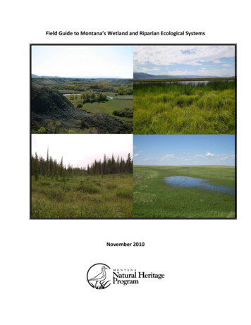
Field Guide to Montana’s Wetland and Riparian Ecological SystemsNovember 2010
Field Key to Wetland and Riparian Ecological Systems ofMontana1a. Wetland defined by groundwater inflows and peat (organic soil) accumulation of at least 40 cm(unless underlain by bedrock). Vegetation can be woody or herbaceous. If the wetland occurs within amosaic of non-peat forming wetland or riparian systems, then the patch must be at least 0.1 hectares(0.25 acres). If the wetland occurs as an isolated patch surrounded by upland, then there is no minimumsize criteria. . Rocky Mountain Subalpine-Montane Fen1b. Wetland does not have at least 40 cm of peat (organic soil) accumulation or occupies an area lessthan 0.1 hectares (0.25 acres) within a mosaic of other non-peat forming wetland or riparian systems . 22a. Total woody canopy cover generally 25% or more within the overall wetland/riparian area. Anypurely herbaceous patches are less than 0.5 hectares and occur within a mosaic of woody vegetation.Note: Relictual woody vegetation such as standing dead trees and shrubs are included here . . GO TO KEY A: Woodland and Shrubland Ecological Systems2b. Total woody canopy cover generally less than 25% within the overall wetland/riparian area. Anywoody vegetation patches are less than 0.5 hectares and occur within a mosaic of herbaceous wetlandvegetation . GO TO KEY B: Herbaceous Ecological SystemsKEY A: Woodland and Shrubland Ecological Systems1a. Woody wetland associated with any stream channel, including ephemeral, intermittent, orperennial (Riverine HGM Class) . 21b. Woody wetland associated with the discharge of groundwater to the surface or fed by snowmelt orprecipitation. This system often occurs on slopes, lakeshores, or around ponds. Sites may experienceoverland flow but no channel formation. (Slope, Flat, Lacustrine, or Depressional HGM Classes) . 82a. Riparian woodlands and shrublands of the montane or subalpine zone . 32b. Riparian woodlands and shrublands of the plains, foothills, or lower montane zone . 43a. Montane or subalpine riparian woodlands (canopy dominated by trees), occurring as a narrowstreamside forest lining small, confined low- to mid-order streams. Common tree species include Abieslasiocarpa, Picea engelmannii, Pseudotsuga menziesii, and Populus tremuloides . Rocky Mountain Subalpine-Montane Riparian Woodland3b. Montane or subalpine riparian shrublands (canopy dominated by shrubs with sparse tree cover),occurring as either a narrow band of shrubs lining the streambank of steep V-shaped canyons or as awide, extensive shrub stand (sometimes referred to as a shrub carr) on alluvial terraces in low-gradientvalley bottoms. Beaver activity is common within the wider occurrences. Species of Salix, Alnus, orBetula are typically dominant . Rocky Mountain Subalpine-Montane Riparian Shrubland4a. Riparian woodlands and shrublands of the foothills or lower montane zones of the Northern andMiddle Rockies and the Wyoming Basin. 51
4b. Riparian woodlands and shrublands of the Northwestern or Western Great Plains of easternMontana. 65a. Foothill or lower montane riparian woodlands and shrublands associated with mountain ranges ofthe Northern Rockies in northwestern Montana. This type excludes island mountain ranges east of theContinental Divide in Montana. Populus balsamifera ssp. trichocarpa is typically the canopy dominant inwoodlands. Other common tree species include Populus tremuloides, Betula papyifera, Betulaoccidentalis, and Picea glauca. Shrub understory species include Cornus sericea, Acer glabrum, Alnusincana, Oplopanax horridus, and Symphoricarpos albus. Areas of riparian shrubland and open wetmeadow are common . Northern Rocky Mountain Lower Montane Riparian Woodland and Shrubland5b. Foothill or lower montane riparian woodlands and shrublands associated with mountain ranges ofthe Middle Rockies and the Wyoming Basin. This type also includes island mountain ranges in centraland eastern Montana. Woodlands are dominated by Populus spp. including Populus angustifolia,Populus balsamifera ssp. trichocarpa, Populus deltoides, and Populus fremontii. Common shrub speciesinclude Salix spp., Alnus incana, Crataegus spp., Cornus sericea, and Betula occidentalis. . Rocky Mountain Lower Montane-Foothill Riparian Woodland and Shrubland6a. Woodlands and shrublands of draws and ravines associated with permanent or ephemeral streams,steep north-facing slopes, or canyon bottoms that do not experience flooding. Common tree speciesinclude Fraxinus spp., Acer negundo, Populus tremuloides, and Ulmus spp. Important shrub speciesinclude Crataegus spp., Prunus virginiana, Rhus spp., Rosa woodsii, Symphoricarpos occidentalis, andShepherdia argentea. . Great Plains Wooded Draw and Ravine6b. Woodlands and shrublands of small to large streams and rivers of the Northwestern or WesternGreat Plains. Overall vegetation is lusher than above and includes more wetland indicator species.Dominant species include Populus balsamifera ssp. trichocarpa, Populus deltoides, and Salix spp. . 77a. Woodlands and shrublands of riparian areas of medium and small rivers and streams with little orno floodplain development and typically flashy hydrology . Great Plains Riparian7b. Woodlands and shrublands of riparian areas along medium and large rivers with extensivefloodplain development and periodic flooding . Great Plains Floodplain8a. Woody wetland associated with small, shallow ponds in northwestern Montana. Ponds are ringedby trees including Populus balsamifera ssp. trichocarpa, Populus tremuloides, Betula papyrifera, Abiesgrandis, Abies lasiocarpa, Picea engelmannii, Pinus contorta, and Pseudotsuga menziesii. Typical shrubspecies include Cornus sericea, Amelanchier alnifolia, and Salix spp. Rocky Mountain Wooded Vernal Pool8b. Woody wetland associated with the discharge of groundwater to the surface, or sites with overlandflow but no channel formation. . 99a. Coniferous woodlands associated with poorly drained soils that are saturated year round orseasonally flooded. Soils can be woody peat but tend toward mineral. Common tree species includeThuja plicata, Tsuga heterophylla, and Picea engelmannii. Common species of the herbaceousunderstory include Mitella spp., Calamagrostis spp., and Equisetum arvense . Rocky Mountain Conifer Swamp9b. Woody wetlands dominated by shrubs . 102
10a. Subalpine to montane shrubby wetlands that occur around seeps, fens, and isolated springs onslopes away from valley bottoms. This system can also occur within a mosaic of multiple shrub- andherb-dominated communities within snowmelt-fed basins. This example of the system has the samespecies composition as the riverine example of this system and is dominated by species of Salix, Alnus,or Betula. Rocky Mountain Subalpine-Montane Riparian Shrubland10b. Lower foothills to valley bottom shrublands restricted to temporarily or intermittently floodeddrainages or flats and dominated by Sarcobatus vermiculatus. Greasewood FlatKEY B: Herbaceous Wetland Ecological Systems1a. Herbaceous wetlands of the Northwestern Glaciated Plains, Northwestern Great Plains, or WesternGreat Plains regions of eastern Montana . 21b. Herbaceous wetlands of other regions. 52a. Wetland occurs as a complex of depressional wetlands within the glaciated plains of northernMontana. Typical species include Schoenoplectus spp. and Typha latifolia on wetter, semi-permanentlyflooded sites, and Eleocharis spp., Pascopyrum smithii, and Hordeum jubatum on drier, temporarilyflooded sites .Great Plains Prairie Pothole2b. Wetland does not occur as a complex of depressional wetlands within the glaciated plains ofMontana. 33a. Depressional wetlands in the Western Great Plains with saline soils. Salt encrustations can occur onthe surface. Species are typically salt-tolerant such as Distichlis spicata, Puccinellia spp., Salicornia spp.,and Schoenoplectus maritimus . Great Plains Saline Depression Wetland3b. Depressional wetlands in the Western Great Plains with obvious vegetation zonation dominated byemergent herbaceous vegetation, including Eleocharis spp., Schoenoplectus spp., Phalaris arundinacea,Calamagrostis canadensis, Hordeum jubatum, and Pascopyrum smithii . 44a. Depressional wetlands in the Western Great Plains associated with open basins that have anobvious connection to the groundwater table. This system can also occur along stream margins where itis linked to the basin via groundwater flow. Typical plant species include species of Typha, Carex,Schoenoplectus, Eleocharis, Juncus, and floating genera such as Potamogeton, Sagittaria, andCeratophyllum. . Great Plains Open Freshwater Depression Wetland4b. Depressional wetlands in the Western Great Plains primarily within upland basins having animpermeable layer such as dense clay. Recharge is typically via precipitation and runoff, so this systemtypically lacks a groundwater connection. Wetlands in this system tend to have standing water for ashorter duration than Western Great Plains Open Freshwater Depression Wetlands. Common speciesinclude Eleocharis spp., Hordeum jubatum, and Pascopyrum smithii . Great Plains Closed Depression Wetland5a. Wetlands with a permanent water source throughout all or most of the year. Water is at or abovethe surface throughout the growing season, except in drought years. This system can occur aroundponds, as fringes around lakes and along slow-moving streams and rivers. The vegetation is dominated3
by common emergent and floating leaved species including species of Scirpus, Schoenoplectus, Typha,Juncus, Carex, Potamogeton, Polygonum, and Nuphar. . Western North American Emergent Marsh5b. Herbaceous wetlands associated with a high water table or overland flow, but typically lackingstanding water. Sites with no channel formation are typically associated with snowmelt and notsubjected to high disturbance events such as flooding (Slope HGM Class). Sites associated with a streamchannel are more tightly connected to overbank flooding from the stream channel than with snowmeltand groundwater discharge and may be subjected to high disturbance events such as flooding (RiverineHGM Class). Vegetation is dominated by herbaceous species; typically graminoids have the highestcanopy cover including Carex spp., Calamagrostis spp., and Deschampsia cespitosa .Alpine-Montane Wet Meadow4
Rocky Mountain Subalpine-Montane FenGeneral DescriptionFens occur infrequently throughout the Rocky Mountains from Colorado north into Canada.They are confined to specific environments defined by groundwater discharge, soil chemistry,and peat accumulation. This system includes poor fens, rich fens and extremely rich fens. Fensform at low points in the landscape or near slopes where groundwater intercepts the soilsurface. Groundwater inflows maintain a fairly constant water level year-round, with water ator near the surface most of the time. Constant high water levels lead to accumulation oforganic material, usually greater than 40 centimeters (15 inches) except on sites underlain bylimestone bedrock. In addition to peat accumulation and perennially saturated soils, extremelyrich and iron fens have distinct soil and water chemistry, with high levels of one or moreminerals such as calcium, magnesium, or iron. Fens maintain stream water quality throughdenitrification and phosphorus absorption. They are among the most floristically diverse of allwetland types, supporting a large number of rare and uncommon bryophytes and vascularplant species, as well as providing habitat for uncommon mammals, mollusks and insects. Fensusually occur as a mosaic of herbaceous and woody plant communities. In herbaceouscommunities, there are several plant associations dominated by sedges (Carex species),spikerushes (Eleocharis species), and rushes (Juncus species). Bryophyte diversity is generallyhigh and includes sphagnum (Sphagnum species). Forb diversity is especially high in extremelyrich and iron fens. The woody community is typically composed of willow (Salix species) andbirch (Betula nana) carr shrubland. The surrounding landscape may be ringed with otherwetland systems: fens often grade into marshes, wet meadows or riparian shrublands, and can5
be surrounded by conifer swamps or wet to mesic coniferous forests. In very rare cases, fenscan occur within prairie grasslands in the glaciated Great Plains. Fens are found in scatteredlocations along the Rocky Mountain Front, in the Rocky Mountains and and intermountainvalleys, in the small isolated central mountain ranges, and at higher elevations on the BeartoothPlateau in the southern portion of the state.Diagnostic CharacteristicsSeepage-fed slopes, montane to subalpine elevations, organic peat layer greater than 40 cmdeep, extreme (mineral) rich and iron-rich, saturated soils, bryophytes, graminoidsSimilar SystemsAlpine-Montane Wet MeadowWestern North American Emergent MarshRangeThis system occurs infrequently throughout the Rocky Mountains from Colorado north intoCanada. In Montana, small fens are found in scattered locations in the glaciated plains and inthe small isolated mountain ranges of the central part of the state. The Swan, Stillwater andFlathead valleys have numerous rich and extremely rich fen systems due to the prevalence oflimestone bedrock in the Whitefish, Mission, and Swan mountain ranges. Similarly, rich andextremely rich fens are found along the limestone-rich Front Range east of the ContinentalDivide. East of the Continental Divide, both small and large rich and extremely rich prairie fensoccur on the extreme western Great Plains bordering the Rocky Mountain Front (Lesica, 1986)and rarely, within the northwestern mixed grass prairie (Heidel et al, 2000). Further south inwestern Montana, poor fen systems are more common in the Bitterroot, Lolo, and Beaverheadranges, and are found in the granitic, isolated central Montana island ranges and the BeartoothPlateau in southwestern Montana.EnvironmentThe montane-subalpine fen ecological system is a small-patch system composed of mountainwetlands that support a unique community of plants not found in other types of wetlands. Fensare confined to specific environments defined by groundwater discharge, soil chemistry, andpeat accumulation of at least 40 centimeters (15 inches), although peat accumulations in areasoverlain by gravel, cobble or bedrock may be less. Soils are typically organic histosols with 40centimeters or more of organic material if overlying a mineral soil, or less if overlying bedrock,cobbles or gravels. Histosols range in texture from clayey-skeletal to loamy-skeletal and fineloams. Fens form at low points in the landscape or near slopes where groundwater interceptsthe soil surface. Groundwater inflows maintain a fairly constant water level year-round, withwater at or near the surface most of the time. Constant high water levels lead to accumulationsof organic material. Rich and extremely rich fens are found in areas underlain by limestone.Water chemistry ranges from only slightly acidic to alkaline and is usually distinctly calcareous.Marl deposits (precipitated calcium carbonates) are common in these systems. Tufa deposits orterraces can be seen in some rich fens and are composed of virtually pure calcium carbonate at6
the soil surface, formed by continuous discharge and evaporation of calcite saturatedgroundwater. In northwestern Montana, pH values usually range from 5.9 to 8.4 (Chadde et al.,1998). Poor fens are more common in the northern Rocky Mountains and occur in areasoverlain by non-calcareous bedrock, e.g., argillites and granite. These are usually flat, acidic,and saturated to the surface, sometimes with standing water. Iron rich fens are more rare inoccurrence, and can be strongly acidic (as low as pH 2.98) and associated with geothermalfeatures and bedrock of weathering pyrite, as found in some occurrences in the YellowstonePlateau (Lemly, 2007). Iron rich fens support a diverse bryophyte community, typically have lessvascular plant diversity, and are composed of species dependant on more acidic conditions.Fens develop successionally through lake-filling, flow-through successional processes or bypaludification (Chadde et al., 1998). Lake filling occurs in depressions and is often characterizedby the presence of floating mats and a ring of carr vegetation on the outer margin of thepeatland. Flow-through fens are the most common in the northern Rocky Mountains. Theyoccur along springs, streams, slopes and benches with a constant inflow and outflow ofcalcium-rich water. They are characterized by a series of linear hummocks orientedperpendicular to the slope. Carr shrubland is well developed in flow-through fens due to wellaerated, nutrient-rich water near the inflow and outflow zones. Usually there is an open,nutrient- poor community in the central portion of the fen. Paludification occurs when fensexpand due to a rise in the water table caused by peat accumulation. This process is most oftenobserved near seeps and springs or adjacent to closed basin peatlands where peataccumulation causes wetter conditions along the outer edges. Higher water tables kill existingtrees. In the northern Rocky Mountains, this successional process is limited due to prolongedsummer droughts; however it may be seen in some fen systems at higher elevations.In northwestern Montana, fens occur at montane to subalpine elevations, generally rangingfrom 985-2,165 meters (2,500-5,500 feet). In southwestern Montana, subalpine and alpine fensoccur at higher elevations (Heidel and Rodemaker, 2008). These communities typically occur inseeps and wet sub-irrigated meadows in narrow to broad valley bottoms. Surface topography istypically smooth to concave with lake-fill peatlands or with slopes ranging from 0 to 10 percentin flow-through fens.VegetationFloristically, rich and extremely rich fens support the greatest vascular plant species diversity ofall peatland types in the Rocky Mountains. Extremely rich fens are characterized by high speciesdiversity and a mosaic of herbaceous and woody plant communities. In contrast, poor fens havescattered vascular plant cover and lower species diversity but are characterized by a nearlycontinuous and diverse cover of mosses and other bryophytes.Several vascular plants have been identified as extremely rich or rich fen indicators in Montana,and some of these species are uncommon or rare. Indicators include: sage-leaf willow (Salixcandida), simple bog sedge (Kobresia simpliciuscula), Bellardii bog sedge (Kobresiamyosuroides), Rolland’s small clubrush (Trichophorum pumilum), little green sedge (Carexviridula), northern single spike sedge (Carex scirpoidea), pale sedge (Carex livida), bulblet-7
bearing water hemlock (Cicuta bulbifera), slender cottongrass (Eriophorum gracile), greenkeeled cottongrass (Eriophorum viridicarinatum), beaked spikerush (Eleocharis rostellata),northern bog violet (Viola nephrophylla), pale bog laurel (Kalmia polifolia), Kalm’s lobelia(Lobelia kalmii), and yellow widelip orchid (Liparis loeselii). Other orchids such as gianthelleborine orchid (Epipactis gigantea) are found in open sedge-dominated portions of the fensystem, while one-leaf orchid (Ameorchis rotundifolia), sparrow’s egg ladyslipper (Cypripediumpasserinum) and small yellow ladyslipper (Cypripedium parviflorum) occur on raised sphagnumhummocks around trees and shrubs near the perimeter of the fen. These species are foundalmost exclusively in fens or wet forest habitats bordering fens. Poor fens often include speciesfound in more acidic conditions such as pale bog laurel (Kalmia polifolia), rannoch rush(Scheuchzeria palustris) and sundews (Drosera species).In extremely rich and rich fens, the herbaceous community is often dominated by beakedsedges (Carex utriculata or Carex rostrata), water sedge (Carex aquatilis), mud sedge (Carexlimosa), woolyfruit sedge (Carex lasiocarpa), spikerush (Eleocharis species), cottongrass(Eriophorum species), rushes (Scirpus species and Trichophorum species) and bulrushes(Shoenoplectus species). Other frequent species include Buxbaum’s sedge (Carex buxbaumii),analogue sedge (Carex simulata), northern bog sedge (Carex gynocrates), bristly-stalked sedge(Carex leptalea), poor sedge (Carex paupercula), yellow sedge (Carex flava), hair sedge (Carexcapillaris), silvery sedge (Carex canescens), lens sedge (Carex lenticularis), Baltic rush (Juncusbalticus), northern rush (Juncus alpino-articulatus), dagger leaf rush (Juncus ensifolius),threadleaf rush (Juncus filiformis), common spike rush (Eleocharis palustris), and few-floweredspike rush (Eleocharis quinqueflora). Common grasses include bluejoint reedgrass(Calamagrostis canadensis), tufted hairgrass (Deschampsia cespitosa), and fringed brome(Bromus ciliatus).Rich and extremely rich fens also support high forb diversity. Common species include showypussytoes (Antenarria pulcherrima), bog orchid (Plantanthera species), buckbean (Menyanthestrifoliata), elegant death camas (Zigadenus elegans), grass-of-parnassus (Parnassia species),beautiful shooting-star (Dodecatheon pulcherrinum), pink elephant’s head (Pedicularisgroenlandica), arrow-grass (Triglochin palustris), and Siberian chives (Allium schoenoprasum).At subalpine elevations, common butterwort (Pinguicula vulgaris) often occurs near seeps orsprings, in areas where there is marl accumulation or on tufa deposits or terraces.In Montana, wet, floating Sphagnum-dominated mats are associated with open water edges ordepressional areas of fen systems. Bryophyte floating mats often consist of Meesia moss(Meesia triquetra), Scorpidium moss (Scorpidium species), Magellan’s peatmoss (Sphagnummagellanicum) and brown peatmoss (Sphagnum fuscum). The bryophyte floating mat supportsa very minor component of sedges such as mud sedge (Carex limosa) and smaller sedges suchas grape sedge (Carex aurea), softleaf sedge (Carex disperma) and inland sedge (Carex interior),as well as cottongrass species (Eriophorum species). Fen indicators such as pale laurel (Kalmiapolifolia), rannoch rush (Scheuchzeria palustris) and sundews (Drosera species) occur on thesefloating mats. Buckbean (Menyanthes trifoliata) is a late seral species from the sedge mat phaseand is often present on floating mats.8
Fens are frequently bordered by willow-bog birch (Salix species-Betula nana glandulosa)dominated carrs. Carr shrubland is well developed in flow-through fens due to highly-aeratednutrient-rich water near the inflow and outflow zones or the perimeter of basin fens. Sageleafwillow (Salix candida) is an indicator species, and sometimes the dominant willow species.Other willow species include autumn willow (Salix serrissima), Bebb’s willow (Salix bebbiana),Drummond’s willow (Salix drummondiana), plane-leaf willow (Salix planifolia), wolf willow(Salix wolfii), and undergreen willow (Salix commutata). Other common carr shrubs includealder (Alnus species), bog birch (Betula nana), alder buckthorn (Rhamnus alnifolia), shrubbycinquefoil (Dasiphora fruticosa), and western Labrador tea (Ledum glandulosum). Engelmannspruce (Picea engelmannii) is the most frequent conifer species associated with fens andforested fen margins of these systems (Hansen and others, 1995).Alliances (A.1403) (Beaked Sedge, Northwest Territory Sedge) Seasonally Flooded Herbaceous Alliance (A.1469) Analogue Sedge Saturated Herbaceous Alliance (A.1404) Aquatic Sedge Seasonally Flooded Herbaceous Alliance (A.1413) Brown Bog Sedge Seasonally Flooded Herbaceous Alliance (A.995) Dwarf Birch Seasonally Flooded Shrubland Alliance (A.1002) Hoary Willow Seasonally Flooded Shrubland Alliance (A.1416) Mud Sedge Seasonally Flooded Herbaceous Alliance (A.1398) Threeway Sedge Seasonally Flooded Herbaceous Alliance (A.1415) Wiregrass Sedge Seasonally Flooded Herbaceous AllianceDynamic ProcessesMountain fens act as natural filters, cleaning ground and surface water. Fens also act assponges by absorbing heavy precipitation, then slowly releasing it downstream, minimizingerosion and recharging groundwater systems. Persistent groundwater and cold temperaturesallow organic matter to accumulate, forming peat, which allows classification of wetlandswithin this system as fens. Peat accumulates at the rate of 8 to 11 inches per 1000 years,making peatlands a repository of 10,000 years of post-glacial history.ManagementLand uses surrounding fens can potentially alter the hydrology and nutrient inputs of thesesystems, thus changing their underlying processes. Increased land use within 100 meters hasbeen found to be correlated with increased nutrient levels in peatlands in Montana, suggestingthat setbacks should be 100 meters or more for adequate protection (Jones 2003). Draining,heavy cattle use, and irrigation practices can also alter hydrology and result in the loss ofspecies diversity. Localized peat mining may occur on private lands.Restoration ConsiderationsThe degree of damage that has occurred in a fen has a significant impact on the prospects forrestoration. Peat mining will cause irreversible damage to fen systems because Rocky Mountainfens build peat so slowly (8 to 11 inches per 1,000 years). In fen systems where water has beendrained or altered, the original hydrology of the system must be restored before any vegetation9
restoration can be considered. If water levels are restored, re-growth and re-colonization ofpeat mosses can occur, although this is a very slow process. In deeper waters, regenerationdepends on whether residual peat layers will become buoyant. Regeneration largely dependson water chemistry and residual peat layer quality. When peat quality is inadequate, shallowinundation is recommended (Smolders et al., 2002).Heavy cattle use in a fen system can alter the hydrology by damaging soils within the fensystem. Soil compaction and pugging within the peat layer will change surface water flow.Heavy cattle use can also alter the successional processes within the sedge- dominated area ofa fen. Cattle hoof action can lead to pugging and hummocking, creating microsites whereshrubs can become established, changing the sedge-dominated meadow to carr shrubland.Original Concept AuthorsNatureserve Western Ecology GroupMontana Version AuthorsT. Luna, L.K. Vance, C. McIntyreVersion Date1/17/2010Literature CitedChadde SW, Shelly JS, Bursik RJ, Moseley RK, Evenden AG, Mantas M, Rabe F, Heidel B. 1998.Peatlands on national forests of the northern Rocky Mountains: ecology andconservation. Ogden, UT: USDA Forest Service, Rocky Mountain Research Station;Report nr RMRS-GTR-11.Hansen PL, Pfister RD, Boggs K, Cook BJ, Joy J, Hinckley DK. Classification and management ofMontana's riparian and wetland sites. No. 54, 1-646. 1995. Montana Forest andConservation Experiment Station, School of Forestry, University of Montana.Miscellaneous Publication.Heidel B, Cooper SV, Jean C. 2000. Plant species of special concern and plant associations ofSheridan County, Montana. Report to the U.S. Fish and Wildlfie Service. Helena,Montana: Montana Natural Heritage Program; -22 pp. plus appendices.Heidel B, Rodemaker E. 2008. Inventory of peatland systems in the Beartooth Mountains,Shoshone National Forest, Park County, Wyoming. Laramie, Wyoming: Wyoming NaturalDiversity database; Report nr Prepared for: Environmental
Constant high water levels lead to accumulation of organic material, usually greater than 40 centimeters (15 inches) except on sites underlain by limestone bedrock. In addition to peat accumulation and perennially saturated soils, extremely . wetland systems: fens often grade into marshes, wet meadows or riparian shrublands, and can . 6