Transcription
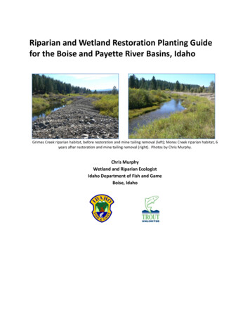
Riparian and Wetland Restoration Planting Guidefor the Boise and Payette River Basins, IdahoGrimes Creek riparian habitat, before restoration and mine tailing removal (left); Mores Creek riparian habitat, 6years after restoration and mine tailing removal (right). Photos by Chris Murphy.Chris MurphyWetland and Riparian EcologistIdaho Department of Fish and GameBoise, Idaho
ACKNOWLEDGMENTSThis project is a partnership project between Idaho Department of Fish and Game (IDFG) andTrout Unlimited. Don Kemner (IDFG) and Pam Elkovich of Trout Unlimited provided valuableinput on all phases of the project. Angie Schmidt (IDFG) conducted GIS analyses of watershedand stream reach condition. Jennifer Miller (IDFG) assisted with GIS tasks. Various IDFG staffand volunteers assisted with past vegetation field work, data management, and GIS work.Funding was provided by Idaho Department of Lands (IDL) through a State and Private Forestrygrant by the USDA Forest Service. Thanks to Joyce Jowdy (IDL) for grant administration.Idaho Department of Fish and Game adheres to all applicable state and federal laws and regulations related todiscrimination on the basis of race, color, national origin, age, gender, disability, or veteran’s status. If you feel youhave been discriminated against in any program, activity, or facility of IDFG, or if you desire further information,please write to: Idaho Department of Fish and Game, P. O. Box 25, Boise, ID 83707.This publication will be made available in alternative formats upon request. Please contact IDFG for assistance.Supported by funds from the Idaho Department of Lands in cooperation with the USDA Forest Service.The United States Department of Agriculture prohibits discrimination in all its programs and activities on the basisof race, color, national origin, gender, religion, age, disability, political beliefs, sexual orientation, and marital orfamily status. To file a complaint, call (202) 720-5964.Costs associated with this publication are available from IDFG in accordance with Section 60-202, Idaho Code. rcbBOC 11-2011 50/41918i
KEY WORDSplanting guide, restoration, riparian, wetland, vegetation, habitat, plant community, watershed,watershed approach, Boise River, Payette RiverSUGGESTED CITATIONMurphy, C. 2012. Riparian and Wetland Restoration Planting Guide for the Boise and PayetteRiver Basins, Idaho. Prepared for Idaho Department of Lands and U. S. Forest Service. IdahoDepartment of Fish and Game, Boise, ID. 61 pp.ii
TABLE OF CONTENTSINTRODUCTION1What are riparian and wetland habitats, and why are they important?What is the problem?What does good or excellent condition riparian and wetland habitat look like?Watersheds—how do they influence riparian and wetland habitats?Why restore riparian and wetland habitats?What are native plants and why should they be planted?How to restore riparian habitatPLANTING GUIDE12455678Which watershed type are you in?Which elevation zone within the watershed are you in?Which riparian or wetland habitats do you want to restore?Determining the Planting Zone for riparian and wetland habitatsPlant ListsDevelop a planting strategy--before and after restorationWhere to get native plants for restorationResourcesHow the guide was developediii81518233055565761
INTRODUCTIONThe purpose of this guide is to help landowners, communities, the U. S. Forest Service, andothers decide which plants are most appropriate for restoring riparian and wetland habitats attheir site of interest. The guide is focused on the Boise and Payette River basins, but adjacentareas, such as the upper South Fork and Middle Fork of the Salmon River and Johnson Creek,are encompassed. We have included background information to emphasize the importance ofriparian and wetland restoration and introduce some of the processes creating these habitats inour watersheds. A list of information resources and potential sources of native plants isincluded at the end. We hope it reaches the broadest audience and increases the knowledgeand desire to restore these important and beautiful habitats for future generations.What are riparian and wetland habitats, and why are they important?Riparian habitats include the typically dense and lush vegetation growing along streams, rivers,springs, wetlands, ponds, and lakes. They are made up of specially adapted plants that are, forat least part of the year, dependent on the presence of water, such as from flooding and highwater tables fed from adjacent water bodies through the soil. They are the transition zonebetween aquatic or wetland habitats and dry uplands. Importantly, not all riparian and wetlandhabitats are alike--their characteristics are expressions of the watershed environment theyoccur in. Riparian habitats often form on sand, silt, and gravel deposited from river and streamflooding, such as on islands and bars, banks, and terraces. They often consist of areasinfluenced by frequent flooding (such as every year or every other year) and areas locatedabove the height of frequent flooding, but still low enough in the valley bottom where plantscan tap into groundwater and where floods still occur, but much less frequently.Streams and rivers in the Boise and Payette River basins provide us with drinking and irrigationwater, habitat for fish and aquatic life, and, of course, water to float our rafts and kayaks, take aswim in, or cast a line on a hot summer day. Think of riparian habitats as ribbons of green thatprotect the streams and rivers. They are the fortress of green that keep the sandy and gravellystream banks from washing away during our spring floods. They slow the runoff of spring snowmelt, lessening the amount of flooding. Riparian habitats can capture silt or other pollutantsthat enter streams during floods, even helping to build their own soil. Riparian areas andwetlands buffer streams and rivers from sediment eroding from upslope land uses, stormwaterrunoff from urban areas, as well as underground septic system drainage. Riparian trees andshrubs shade streams and rivers, helping to reduce stream temperatures in the summer. Bydoing this, they help maintain cool, clear, and clean streams flowing late into the summer.Trout require water less than about 60 degrees F for spawning. Pools and riffles in streams donot become silted in. Streams meander as much as the valley allows. Large chunks of wood1
falling into streams from riparian trees and big shrubs create habitat for insects and fish, andfeed nutrients into the aquatic ecosystem.Although riparian and wetland habitats occupy only about 3% of the land in Idaho, they are vitalfor many birds, fish, amphibians, mussels, and other wildlife (e.g., bats, moose, and beaver), aswell as the insects, spiders, and plants that feed them. Almost half of Idaho’s bird species nestin riparian habitat, and wetlands are nesting habitat for almost another third. About 10% ofIdaho’s birds are completely dependent on these habitats and rarely found anywhere else.Beneficiaries of healthy riparian habitat. Wild rainbow trout, North Fork Boise River (left), and bull moose on SilverCreek (right). Photos by Chris Murphy.What is the problem?While the riparian habitat of many streams and rivers in the Boise and Payette River basins is ingood or excellent condition, it is also clear that the legacy of historic activities and current landuses have left scars on many of our most important riparian and wetland habitats. This isespecially true in our wider, low elevation valleys where most homes and towns occur.Improper, or too much, livestock grazing and browsing can decrease or eliminate seedlings ofblack cottonwood, aspen, willow, and other trees and shrubs, as well as preferred nativegrasses, sedges, and forbs. Farming practices also sometimes negatively impact native riparianplants and animals. As deeply rooted native plants are reduced, noxious weeds and otherinvasive, non-native species sometimes sprout on exposed soil and thrive with the lack ofcompetition. Stream and river banks also sometimes collapse from the force of livestocktrampling and trails. Similar effects can occur from any excessive amount of ground-disturbingactivities, including trails and roads in riparian areas created by off-road vehicles, motorcycles,mountain bikes, and camping. Even too many fisherman trails can cause damage (yes, we canlove our streams too much). These impacts have resulted in less shading of streams, excessive2
amounts of sand and silt entering the stream and clogging trout spawning beds, and wider,shallower, and warmer streams throughout the Boise and Payette River basins.Other land uses, including forest management, mining, building and maintenance of roads andhighways, home and cabin construction, flood control, and the development associated withour small towns and cities (such as sewage treatment facilities) are all subject to regulationsprotecting our environment, streambeds, riparian habitat, and wetlands. However, together,current and past development has disrupted natural flows of streams and rivers, cleared ordisrupted riparian habitat, filled wetlands, and decreased the ability of wildlife to fully use thesehabitats. Well-intentioned streambank stabilization techniques, such as planting non-native,invasive trees and shrubs, placement of large rocks (rip-rap), and dumping of large debris (likeold cars), have displaced natural riparian habitat. Straightening streams or putting them intounderground pipes or culverts also reduce habitat. Lawns stretching from homes tostreambanks lack habitat and are prone to erosion. Historic mining that dredged stream bedsand deposited cobble and gravel tailings in large piles within valley bottoms has had a major,long lasting negative impact on vast areas of riparian habitat, especially along Mores andGrimes Creeks. Although beaver populations have recovered in many of suitable streamswithin the Boise and Payette River basins, historic trapping eliminated this important creator ofwetlands from many areas, resulting in lowered groundwater and less riparian habitat. Otheron-going activities, such as diversions of streams for irrigation, can impact riparian habitats.Low altitude aerial photo of dredge mine tailings alongGrimes Creek, showing narrow bands of floodplain anddiscontinuous, degraded riparian habitat. Photo courtesy ofTrout Unlimited.Beaver dam on Grimes Creek. Beaver are important fornatural recovery of degraded riparian habitat. Photo byChris Murphy.3
What does good or excellent condition riparian and wetland habitat look like?Montane riparian habitat in excellent condition. Tenmile Creek,tributary of the South Fork Payette River (left), Lake Fork Creek,tributary of the North Fork Payette River (right). Photos by ChrisMurphy.Because rivers and streams are so variable due to the climate, elevation, bedrock, shape andsteepness of valleys, soils, and other factors, the riparian habitats also vary in their appearance.They range from forests or dense shrublands to grassy meadows. However, in general,excellent forested riparian habitat in southern Idaho will have trees of multiple ages that form acanopy of several heights, including standing dead trees, or snags, that provide habitat formany species. There is typically several dense layers of shrubs underneath the trees, withgrass-like and wildflower species (forbs) filling the few sunny gaps that exist. Shrubby riparianhabitat will lack trees, but often have a few layers of shrubs of different heights. The more agesof trees and shrubs the better, from seedlings and saplings, to mature and old, or even dying,individuals. These habitats should be nearly continuous along the stream or river, ideallycovering the banks and shading the water during much of the day. The broader and flatter thevalley bottom, the wider the floodplain and riparian habitat tends to naturally be. Wetlands areoften interspersed in low-lying areas and old oxbows or backwater sloughs of rivers. Incontrast, streams in steep and narrow mountain valleys have narrower riparian habitat, but insome valleys the riparian trees and shrubs appear to blend seamlessly with adjacent vegetationof canyon slopes. In high mountain headwater valleys, glacial processes often created wide,gently sloped valley bottoms that now have narrow, winding, and deep streams that meanderthrough lush, wet sedge meadows and willow shrublands.4
Dense riparian vegetation effectively shading streams and stabilizing stream banks, Elk Creek (a lower montanetributary of Mores Creek) (left) and Belvidere Creek (a montane tributary of Big Creek) on Payette National Forest(right). Photos by Chris Murphy.Watersheds—what are they and how do they influence riparian and wetland habitats?Watersheds are areas of land divided by ridges, hills, and mountains within which all the rainand snowmelt ultimately drains into the same stream or river. They can be of any size, but forthe purpose of this guide we are using 6th-level hydrologic units as delineated by the U. S.Geological Survey to define “watersheds.” Watersheds are important because any upstreamdisturbance or pollution impacts all landowners downstream in that watershed—it is allconnected. All watersheds occurring within the larger Boise and Payette River basins wereincluded because they share similar environmental conditions and vegetation.Riparian habitats are dynamic. They have a range of plant communities occurring in balancewith natural disturbance and flooding regimes that reflect the environment of the watershedswithin which they occur. Key drivers in the function and formation of riparian and wetlandhabitats include climate, flooding regimes, bedrock, and soils. Climate influences thetemperature of soils, precipitation timing and amount, snowpack size, and pattern of melting.Resultant flooding (hydrologic) regimes determine stream flow patterns and volume. Climateand hydrology, in turn, act upon bedrock. Erosion creates a variety of sediment types whichform the basis for valley soils. Slope steepness and aspect (topography) and elevation,combined with past glaciations, affect drainage patterns, valley shapes, and valley sizes. All ofthese factors ultimately determine environments for riparian and wetland habitats. As a result,riparian and wetland habitats occurring in similar watersheds typically have similar vegetation.Why restore riparian and wetland habitats?The benefits of restoring riparian and wetland habitats are many and can save communitiessubstantial amounts of money. Restoration can:5
maintain higher stream flows longer into the summer improve the fertility of soil and its ability to absorb rain and snowmelt raise the water table, making it more accessible to plants late into the summer keep water clear by reducing the amount of sediment entering the stream, benefiting waterquality stabilize stream banks with lush, dense, and deep-rooted plants, preventing erosion increase the number of fish, wildlife, and plant species and their populations slow the flow of spring runoff, reducing the size and frequency of flooding improve the quality of recreation raise the value of your propertyIn wider valleys, riparian restoration can promote natural stream meandering. This processcreates floodplains on inside bends of the channel where sand and gravel deposits form habitatfor willows and black cottonwood tree seedlings to take root. Point bars alternate with deeppools that form on outside meander bends where overhanging shrubs and fallen logs createexcellent cover for fish. Streams tend to become deeper and narrower, with an appropriatebalance of deep pools and shallow, rocky riffles.Foothill floodplain of Weiser River (left), showing highdiversity of riparian habitats including coyote willows onthe point bar and an old growth black cottonwood forestwith a mature tall-shrub understory on high terraces.Photo by Ed Bottum.What are native plants and why should they be planted?A key feature of any excellent riparian or wetland habitat is that it is dominated by native plantspecies. Native plants, for the purpose of this planting guide, are those that grew naturally orevolved in the Boise and Payette River basins before humans introduced plants from distantplaces. This is not to say that humans aren’t part of the natural world, nor to discount the roleNative Americans had in moving plants and cultivating them for food. However, in general,native plants have grown in an area long enough (such as since the last ice ages, about 10,000years ago) to be specially adapted to the current local climate, soils, and moisture found in theregion. And what we consider native now may adjust as climate changes in the future and6
plants migrate. In some cases, varieties of plant species have even evolved unique traitsspecific to watersheds that make them ideally suited to the environmental conditions.Moreover, native insects and wildlife co-evolved with native plants and depend on them fortheir survival and reproduction. In contrast, the vast majority of plants introduced by humanshave invaded during just the last 175 years. Without grazing animals, diseases, or insect pestsfrom where they originally evolved, their populations can grow dramatically, crowding out thenative plants that our wildlife evolved with.How to restore riparian habitat--go slow, work with nature, and be cautiousRestoration of riparian habitat can be simple and inexpensive, or complex and very expensive,depending on the situation. The first step in any restoration project is to identify the source ofthe problem causing degradation or loss of riparian and wetland habitat. Landowners usuallyknow their land, and often the neighboring land, better than anyone else. Be observant. Doesyour site flood? For how long, and how often? Take note of changes to your riparian habitat.Are they due to ongoing disturbances, such as from livestock grazing or recreation, or are theydue to past impacts, such as from roads, housing development, or mining? Riparian and manywetland habitats are naturally resilient and often recover in just a few years if the source of thedisturbance is removed and the area protected from further disturbance. An example might beimproving livestock management so as to minimize grazing and browsing in riparian or wetlandhabitats. This relatively low cost approach is recommended first. If natural recovery doesn’toccur with removal of disturbance, then something else may be happening that is not easy tosee. It could be due to other disturbances upstream that are affecting land downstream in thewatershed. There may be a hidden problem in the soil. Or is the water table too deep? Thiscould be caused by beaver removal or a straightened and unstable stream channel that has cutdown into the valley. If so, it could be time to call experts in assessing riparian and watershedcondition and developing restoration plans. It may be impossible to fully restore severelydegraded habitat.If riparian or wetland habitat is damaged due to past land uses, knowing the degree of damageis very important. For example, if your property includes large areas of historic placer miningtailings, then it is likely that most of the topsoil is gone, the stream is confined and lacks theability to meander and flood, and riparian vegetation is hard to find. In this or similar cases, it isimportant to bring in experts in restoration ecology to develop a plan. Such a project isexpensive and has a higher risk of failure. Projects are complex, in terms of working withchanging stream and riparian processes, preventing further damage during restoration, andmeeting regulatory obligations. Do not start moving soil without a real plan and requiredregulatory permits. Anytime stream channels are to be changed, or wetlands (including mostriparian habitats) filled or dredged, permits are required (and these regulations are enforced).7
Before beginning any restoration project, especially those requiring soil excavation or filling, itis recommended to:1) Get advice and technical assistance from experts, including your local Soil ConservationDistrict, Idaho Department of Fish and Game, Idaho Department of Environmental Quality,Natural Resources Conservation Service, U. S. Forest Service, or environmental consultants.2) Obtain funding for your project. Numerous grants are available for riparian and wetlandhabitat restoration, including (but not limited to): Wetlands Reserve Program (WRP) - Seeks to protect, restore, and enhance wetlands onprivate land. It is one of the many Farm Bill Conservation Programs, administered by theNatural Resources Conservation Service. Nonpoint Source Pollution Management Grants administered by the Idaho Department ofEnvironmental Quality through Section 319 of the Clean Water Act can be used to restoreriparian and wetland habitats ns.aspx). 5 Star Restoration Program is a grant administered by the U. S. Environmental ProtectionAgency http://water.epa.gov/grants funding/wetlands/restore/index.cfm Several habitat restoration grants, including the Landowner Incentive Program, are availablefrom the U. S. Fish and Wildlife Service http://www.fws.gov/grants/ Habitat Improvement Program (HIP) - An Idaho Department of Fish and Game program withthe objective to provide technical and financial assistance to private landowners and publicland managers who want to enhance habitat for upland game birds and waterfowl. Wildlife Habitat Incentives Program (WHIP) - This Farm Bill program provides technical andfinancial assistance to landowners for improving wildlife habitat on their land. Environmental Quality Incentives Program (EQIP) – This Farm Bill program providesincentives to landowners to implement conservation practices on their agricultural land,including wildlife habitat management.3) Apply for necessary permits with appropriate agencies. For alterations to wetlands, permitsare required by the U. S. Army Corps of Engineers and Idaho Department of EnvironmentalQuality under Section 404 of the Clean Water Act. Alterations to stream channels below theordinary high water mark require a permit approved by the Idaho Department of WaterResources under the Idaho Stream Channel Protection Act. Other regulations may apply.4) Sign a long term maintenance agreement for stewardship and protection of the restorationsite if required by the grants used to fund the riparian restoration project.8
Process of restoring riparian habitat degraded by dredge mining tailing piles. Grimes Creek riparian area beforerestoration, showing lack of floodplain and riparian vegetation (upper left). Use of a large excavator to removetailing piles and create frequently flooded terrace (upper right). Same floodplain terrace after planting springplanting of native trees and shrubs (lower left). Similar restoration of riparian habitat with mine tailing removalfollowed by planting on Mores Creek, showing 6 full years of growth. Photos by Chris Murphy.If riparian vegetation on a stream bank, floodplain, or high terrace has been disturbed orremoved, but the stream is still meandering and flooding as it has before, then this is an idealsituation for you to undertake a sort of “DIY” approach to restoring riparian habitat. In othersituations, you may want to enhance what riparian vegetation that is already there, filling gapswith native shrubs to shade out noxious weeds or widening the width of the habitat. This is notto say restoration is simple, or even cheap (native plants can be expensive), nor might notsucceed the first time. For example, on drier riparian sites it may be necessary to irrigateplanted trees, shrubs, and herbs until they grow deep roots and become established. Afterplanting, you may need to protect plants from browsing by moose, elk, deer, beaver, orlivestock. But, you, with the help of the community and other resources, can, using this guide,plant the right plants in the right places to improve your chances of successfully restoringriparian habitat. Your family, neighbors, and, most of all, the fish and wildlife that benefitshould thank you.9
PLANTING GUIDEHow to use the Riparian and Wetland Restoration Planting GuideAnswer the following four questions to the best of your ability based on the location of yourrestoration site and observations of the habitats. They will lead you to the appropriate speciesto plant for your site in the table at the end.1) Which watershed type are you in?Based on the location of your restoration site, use the maps on the following pages to identifythe type of watershed you are in. If your site falls on the border of two watershed types, or islocated slightly outside the watersheds mapped, then consult the following descriptions todecide which type is represented at your location. foothills and alluvial river valleys, sedimentary, low relief, semiaridThese watersheds are restricted to the Boise foothills,stretching from about Eagle to Luck Peak Dam. They includenarrow and steep perennial or intermittently flowing streamsin the hills, as well as the Boise River valley. Except for thehighest ridgetops at the heads of these watersheds, the area isnon-forested shrub and grassland.Upper Dry Creek watershed in the Boise foothills. Foothill riparian habitat. Photo by Chris Murphy. high northern mountains and glacial outwash valleys, batholith,high relief, snowyThese watersheds encompass the steep, high elevationheadwaters in the mountains north of the South Fork PayetteRiver, including the highest peaks in the West Mountains (westof Cascade), the upper Deadwood River, and upper Middle ForkPayette River. They include broad, u-shaped glacial carvedvalleys and meadows, as well as lower elevation river valleys.Except for a few south-facing slopes in the lowest rivercanyons, these watersheds are entirely forested.Upper Elk Creek, a tributary of Bear Valley Creek (Middle Fork SalmonRiver basin) flowing through a montane wet meadow. Photo by Chris Murphy.10
high southern mountains, batholith, high relief,snowyThese watersheds span from the TrinityMountains in the south, to Peace Rock and ScottMountain (west of Deadwood Reservoir) in thenorth, to the Sawtooth Mountains in the east.All high, granitic mountains south of the SouthFork Payette River fall in this group. Except forsouth-facing slopes in the lowest river valleys,the entire area is forested.Upper North Fork Boise River. Photo by Chris Murphy. lower montane ridges and mountain stream valleys, batholith and volcanic flows, moderaterelief, warm temperateThese watersheds include foothills, lower mountains,and ridges, from the Danskin Mouintains to most ofthe South Fork Boise River below Anderson RanchDam, Arrowrock and Luck Peak Reservoirs, lowerGrimes and Mores Creeks, and ridges near HorseshoeBend. This is a transitional zone that includes opengrassy or shrubby slopes, ponderosa pine woodlands,and Douglas-fir forests (on northern slopes). Anyvolcanic (basalt) flows in the described area would fallin this group.South Fork Boise River canyon and Danskin Mountains near Prairie. Photo by Chris Murphy. lower montane ridges, mountains, and alluvial valleys, batholith, low relief, temperateThese watersheds occupy most of the North ForkPayette River, including Long Valley. This group alsoincludes upper Squaw Creek and the broad valleysaround Placerville and Idaho City in Grimes and MoresCreeks. Except for a few south-facing slopes, thesewatersheds are nearly entirely forested by ponderosapine and Douglas-fir, with Grand fir trees occur northof Banks. Cold air drains into the broad valleys,creating cold conditions more similar to higherelevation mountain valleys to the east.Lower montane watershed draining into the Payette River near Banks. Photo by Chris Murphy.11
montane ridges and stream valleys, batholith, moderaterelief, cool temperateThese watersheds are characterized by steep graniticslopes transitional between hotter, drier low elevationridges and higher, colder, and snowier mountains. Thegroup includes the valleys of the South Fork Boise Riverabove Anderson Ranch Dam, Middle Fork Boise Riverabove Arrowrock Reservoir, and part of the South ForkPayette River near Lowman. The area is mostly forestedby Douglas-fir (except where wildfires have occurred),but south-facing slopes of river canyons may includeopen woodlands of ponderosa pine or Douglas-fir.Lower Sheep Creek watershed (a tributary of the Middle Fork Boise River), burnt in 1992.Montane riparian habitat. Photo by Chris Murphy. montane ridges and stream valleys, volcanic flows, low relief, semi-aridThis group occurs entirely south of the South ForkBoise River and includes the granitic ridges andbasaltic plateaus forming the divide betweenstreams flowing to the Snake River Plain andthose to the South Fork Boise. It also includesBennett Mountain. Except for high elevations andnorth slopes with Douglas-fir forest and quakingaspen, this group is sparsely forested sagebrushcountry. The area is cold in the winter, but notexcessively snowy.A tributary to Anderson Ranch Reservoir. Photo by Chris Murphy.12
Boise River Basin13
Payette River Basin and adjacent South Fork Salmon, Johnson Creek, and Middle Fork Salmonwatersheds.14
2) Which elevation zone within the watershed are you in?Watersheds often span large elevations, from mountaintops to canyon bottoms, and includeareas of complex topography that alter local climates. The types of riparian and wetlandhabitat present in any watershed will reflect these factors. To help identify habitats present atyour site, the next step is to locate which broad ecological zone of the watershed you are in.Use the following maps to guide you. If you cannot decide which zone best fits your site,consult the following descriptions and look at photos in the introduction section to help you. Foothills - Lower Montane, Low Elevation Valley ZoneThis ecological
What does good or excellent condition riparian and wetland habitat look like? 4 . they help maintain cool, clear, and clean streams flowing late into the summer. Trout require water less than about 60 degrees F for spawning. Pools and riffles in streams do . within the Boise and Payette River basins, historic trapping eliminated this .
