Transcription
Columbia CascadeFire Danger Operating Plan
Table of ContentsFire Danger Operating Plan -------------------------------------------------- 6Introduction ---------------- 6Purpose ------------------- 6Operating Plan Objectives --------------------------------------------- 6Policy and Guidance --- 7Preparedness --------------- 7Preparedness Plan ----- 7Preparedness ------ 7Staffing Plan ------------- 7Staffing Levels ------- 8Fire Danger Adjective --------------------------------------------- 8Prevention Plan -------- 8Restriction Plan --------- 8Response -------------------- 8Initial Response Plan -- 8Response Level ------ 9Local Mobilization -------------------------------------------------- 9Fire Danger Planning Area Inventory ---------------------------------- 10Administrative Units - 10Weather Stations ----- 11Fire Danger Rating Areas ---------------------------------------------- 12Fire Danger Decision Analysis ------------------------------------------- 13Appendix A- Fire Danger Rating Area Analysis ------------------------- 16South Cascades (SOCA) - 17Description ------------- 17Fire Danger Problem Analysis ---------------------------------------- 18Fire Danger Decision Analysis ---------------------------------------- 20Decision Points -------- 22Staffing, Response, and Fire Danger Rating Levels ------------- 22Upper White Salmon (UPWS) ------------------------------------------- 23Description ------------- 23Fire Danger Problem Analysis ---------------------------------------- 242
Fire Danger Decision Analysis ---------------------------------------- 26Decision Points -------- 28Staffing, Response, and Fire Danger Rating Levels ------------- 28Mt Hood East (MHFE) --- 29Description ------------- 29Fire Danger Problem Analysis ---------------------------------------- 30Fire Danger Decision Analysis ---------------------------------------- 32Decision Points -------- 34Staffing, Response, and Fire Danger Rating Levels ------------- 34Mt Hood West (MHFW) -------------------------------------------------- 35Description ------------- 35Fire Danger Problem Analysis ---------------------------------------- 36Fire Danger Decision Analysis ---------------------------------------- 38Decision Points -------- 40Staffing, Response, and Fire Danger Rating Levels ------------- 40Appendix B- Staffing ------ 41Appendix C- Preparedness Plan -------------------------------------------- 47Appendix D- Response Plan ------------------------------------------------- 53North Zone GPF -------------- 58GPFN01 - Mineral Block - 58GPFN02 – Mineral Block ----------------------------------------------- 59GPFN03 – Glacier View -- 60GPFN04 – Glacier View Wilderness ------------------------------------ 61GPFN05 – Nisqually WUI -------------------------------------------------- 62GPFN06 – Silver Creek --- 63GPFN07 – Tatoosh Wilderness ------------------------------------------ 64GPFN08 – Ohanapecosh -------------------------------------------------- 65GPFN09 – William O Douglas Wilderness ----------------------------- 66GPFN10 – Randle ------ 67GPFN11 – Packwood WUI ------------------------------------------------ 68GPFN12 – South Point --- 69GPFN13 – Goat Rock Wilderness --------------------------------------- 70GPFN14 – White Pass WUI ----------------------------------------------- 713
GPFN15 – Lower Cispus - 72GPFN16 – Cispus WUI --- 73GPFN17 – Upper Cispus - 74GPFN18 – -------------- 75South Zone GPF -------------- 76GPFS01 – Monument ---- 76GPFS02 – General South ----------------------------------------------- 77GPFS03 – Indian Heaven & Trapper Cr. Wilderness Area --------- 78GPFS04 – Huckleberry --- 79GPFS05 – Mt. Adams Wilderness --------------------------------------- 80East Zone MHF --------------- 82MHFE01 – Hatfield Wilderness ---------------------------------------- 82MHFE02 – Defiance ------ 83MHFE03 – Lost Lake ----- 84MHFE04 – Red Hill ------- 85MHFE05 – HWY 35 ------- 86MHFE06 – Mt. Hood Wilderness East --------------------------------- 87MHFE07 – White ---- 88MHFE08 – Clear Lake ---- 89MHFE09 – Bear Springs - 90MHFE10 – Rock Creek --- 91MHFE11 – Badger/White Salmon Wilderness ----------------------- 92MHFE12 – Tygh Creek --- 93MHFE13 – Camp Friend - 94MHFE14 – Camp Baldwin ------------------------------------------------- 95MHFE15 – 5 Mile --------- 96MHFE16 – The Dalles Watershed --------------------------------------- 97MHFE17 – North Mill ---- 98MHFE35 – Upper HWY 35 ------------------------------------------------ 99MHFE36 – Lower Mt Hood Wilderness East ----------------------- 100MHFE37 – Upper White ------------------------------------------- 101MHFE38 – Frog Lake --- 102West Zone MHF ------------ 1044
MHFW01 – Bull Run Watershed Management Unit ------------- 104MHFW02 – Lolo Pass -- 105MHFW03 – West Mt. Hood Wilderness ----------------------------- 106MHFW04 – HWY 26 ---- 107MHFW05 – Salmon-Huckleberry Wilderness ---------------------- 108MHFW06 – Government Camp --------------------------------------- 109MHFW07 – Wildcat ---- 110MHFW08 – La Dee Flat -------------------------------------------------- 111MHFW09 – Roaring River Wilderness (Includes Portions of Clackamas Wilderness) ----------------------- 112MHFW10 – Timothy Lake ----------------------------------------------- 113MHFW11 – West Clackamas Wilderness --------------------------- 114MHFW12 – Memaloose ------------------------------------------------- 115MHFW13 – Fish Creek - 116MHFW14 – Ripplebrook ------------------------------------------------ 117MHFW15 – Collawash - 118MHFW16 – Rhododendron (Rho) Ridge ---------------------------- 119MHFW17 – East Clackamas Wilderness ----------------------------- 120MHFW18 – Bull of the Woods Wilderness ------------------------- 121MHFW19 – ----------- 122MHFW20 – Olallie Lake ------------------------------------------------- 123CGF ---------------------------- 124CGF50 – OR: Multnomah County/WA: West Boundary to Dog Mountain ------------------------------------ 124CGF51 – OR: Hood River East to Wasco County / WA: Dog Mt. to Eastern CGF Boundary Line --------- 126CGF52 – Wasco Co. East to Mid-Columbia Fire & Rescue ------ 128CGF53 – Columbia Rural South to Dufur ---------------------------- 130CGF54 – Dufur South to WSA Boundary ---------------------------- 132CGF55 – Mid-Columbia Fire & Rescue East to the Deschutes River -------------------------------------------- 134Appendix E- Prevention Plan --------------------------------------------- 1365
Fire Danger Operating PlanIntroductionPurposeThe public, industry, and our own agency personnel expect the wildland fire management agencies toimplement appropriate and timely decisions which ultimately result in safe, efficient, and effectivewildland fire management actions. This plan is intended to document a decision-making process foragency administrators, fire program managers, fire operations specialists, dispatchers, agencycooperators, and firefighters by establishing planning and response levels using the best availablescientific methods and historical weather/fire data. An appropriate level of preparedness to meetwildland fire management objectives is based upon an assessment of vegetation, climate, andtopography utilizing the National Fire Danger Rating System (NFDRS). This plan provides a science-based“tool” for fire managers to incorporate a measure of risk associated with decisions which have thepotential to significantly compromise safety and control of wildland fires.Operating Plan Objectives1.2.3.4.5.6.7.8.9.10.Provide a tool for agency administrators, fire managers, dispatchers, and firefighters tocorrelate fire danger ratings with appropriate fire business decisions in fire danger planningarea.Delineate fire danger rating areas (FDRAs) in fire danger planning area with similar climate,vegetation, and topography.Establish a fire weather-monitoring network consisting of Remote Automated WeatherStations (RAWS) which comply with NFDRS Weather Station Standards (PMS 426-3).Determine climatological breakpoints and fire business thresholds using the WeatherInformation Management System (WIMS), National Fire Danger Rating System (NFDRS),FireFamilyPlus software to analyze and summarize an integrated database of historical fireweather and fire occurrence data.Define roles and responsibilities to make fire preparedness decisions, manage weatherinformation, and brief fire suppression personnel regarding current and potential firedanger.Determine the most effective communication methods for fire managers to communicatepotential fire danger to cooperating agencies, industry, and the public.Provide guidance to personnel outlining specific daily actions and considerations at eachpreparedness level.Identify seasonal risk analysis criteria and establish general fire severity thresholds.Identify the development and distribution of fire danger pocket cards to all personnelinvolved with fire suppression within the fire danger planning area.Identify program needs and suggest improvements for implementation of the Fire DangerOperating Plan.IMPORTANT NOTE: This plan deviates from other template in that analysis is documented by eachindividual Fire Danger Rating Area in Appendix A. This was done to allow fire managers an easier methodto reference data specific to each FDRA. As such, the first sections of the plan are broad and primarilyinclude definitions, explanation of subordinate plans (Staffing Plan, Response Plan, etc) and analysismethodology.6
Policy and GuidancePolicy and guidance regarding thedevelopment of Fire DangerOperating Plans can be found in theInteragency Standards for Fire &Aviation Operations (Red Book).Agency-specific direction can befound in U.S. Forest Service –Manual 5120 - Fire Management –PreparednessPolicy and guidance requirenumerous unit plans and guides inorder to meet preparednessobjectives. Some of these plans andguides are inter-related; some plansand guides provide the basis forother plans/guides.Figure 1. Plan relationshipsThis Fire Danger Operating Plan (FDOP) guides the application of information from decision supporttools (such as NFDRS) at the local level. This FDOP documents the establishment and management of afire weather station network and describes how fire danger ratings will be applied to local unit firemanagement decisions. The actual implementation is described in the supplemental action plans.PreparednessPreparedness PlanPreparedness plans provide management direction given identified levels of burning conditions, fireactivity, and resource commitment, and are required at national, state/regional, and local levels.Preparedness Levels (1-5) are determined by incremental measures of burning conditions, fire activity,and resource commitment. Fire danger rating is a critical measure of burning conditions. ThePreparedness Levels are identified and documented in the Columbia Cascade Fire Danger OperatingPlan; the associated decisions and planned actions are located in Appendix C.Preparedness LevelThe Preparedness Level is a five-tier (1-5) fire danger rating decision tool that is based on NFDRSoutput(s) and other indicators of fire business (such as projected levels of resourcecommitment). Preparedness Levels will assist fire managers with more long-term (seasonal)decisions with respect to fire danger.Staffing PlanThe Staffing Plan describes escalating staffing for each Zone based on increasing Energy ReleaseComponent (ERC). Mitigating actions are designed to enhance the unit’s fire management capabilityduring periods where normal staffing cannot meet initial attack, prevention, or detection needs. The7
decision points are identified and documented in the Columbia Cascade Fire Danger Operating Plan; theassociated decisions and planned actions are located in Appendix B.Staffing LevelsStaffing Levels will be used to make daily internal fire preparedness and operational decision. Atthe Forest level, the staffing level can form a basis for decisions regarding the “degree ofreadiness” for initial attack resources and support resources. Staffing Levels will generally be settwice per week during Fire Leadership and Staffing calls. Each Zone will staff to the ForestStaffing Level which is determined by the highest Staffing Level across any Fire Danger RatingArea (FDRA) on that Forest.Fire Danger Adjective RatingIn 1974, the Forest Service, Bureau of Land Management and State Forestry organizationsestablished five standard Adjective Fire Danger Rating Levels descriptions for public informationand signing.As with Staffing Level, the Adjective Fire Danger Rating Level will be set twice per week duringFire Leadership and Staffing calls. Unlike Staffing Level, Adjective Fire Danger Rating Level maydiffer across a Forest.Prevention PlanPrevention plans document the wildland fire problems identified by a prevention analysis. This analysiswill not only examine human-caused fires, but also the risks, hazards, and values for the planning unit.Components of the plan include mitigation (actions initiated to reduce impacts of wildland fire tocommunities), prevention (of unwanted human-caused fires), education (facilitating and promotingawareness and understanding of wildland fire), enforcement (actions necessary to establish and carryout regulations, restrictions, and closures), and administration of the prevention program. The analysisof fire problems and associated target groups in the Columbia Cascade are documented in this FireDanger Operating Plan; the associated decisions and planned actions are located in Appendix E.Restriction PlanA Restriction Plan is a document that outlines coordination efforts regarding fire restrictions andclosures. It provides an approach for initiating restrictions or closures helps provide consistency amongthe land management partners, while defining the restriction boundaries so they are easilydistinguishable to the public. Based on the fire danger, managers may impose fire restrictions oremergency closures to public lands. Decision points when restrictions and/or closures should beconsidered are identified and documented in the Columbia Cascade Fire Danger Operating Plan; theassociated decisions and planned actions remain in development.ResponseInitial Response PlanInitial response plans, also referred to as run cards or pre-planned response plans, specify the firemanagement response (e.g. number and type of suppression assets to dispatch) within a definedgeographic area to an unplanned ignition, based on fire weather, fuel conditions, fire managementobjectives, and resource availability. Response levels are identified and documented in the ColumbiaCascade Fire Danger Operating Plan. The number and type of suppression resources dispatched to areported fire is documented in the associated initial Dispatch / Response Plan (Appendix D).8
Response LevelResponse Levels are pre-planned actions which identify the number and type of resources(engines, crews, aircraft, etc.) initially dispatched to a reported wildland fire based upon firedanger criteria.Local Mobilization PlanThe Columbia Cascade Communication Center Mobilization Plan identifies standard procedures, whichguide the operations of multi-agency logistical support activity throughout the coordination system. TheMobilization Plan is intended to facilitate dispatch coordination, ensuring the timeliest and most costeffective incident support services available are provided. Communication between Units, GACCs, State,Regional Offices and other cooperative agencies are addressed.9
Fire Danger Planning Area InventoryAdministrative UnitsThis plan serves two Forest Service units, the Gifford Pinchot and Mt Hood National Forests. Firemanagement at the Forest level is shared between the two Forests. Fire management at the Districtlevel is zoned.Zone fire management on the GiffordPinchot is broken into two zones: The NorthZone which encompasses the Cowlitz ValleyRanger District. The South Zoneencompasses Mt Adams Ranger District andMt St. Helens National Volcanic Monument.Figure 2. GPF Ranger DistrictsZone fire management on the Mt Hood is alsobroken into two zones: The East Zone whichencompasses the Barlow and Hood RiverRanger Districts. The West Zone encompassesthe Clackamas River and Zigzag RangerDistricts.Both Forests and all Zones are served by theColumbia Cascade Communication Center.Figure 3. MHF Ranger Districts10
Weather StationsAll Remote Automated Weather Stations (RAWS) comply with the National Wildfire Coordinating Group(NWCG) weather station standards ions/pms4263.pdf). Each RAWS receives, at a minimum, one annual on-site maintenance visit by either the local useror contracted personnel to ensure sensors are within calibration standards and verify site and stationconditions.Table 1. Weather Station InventoryUNITStationNameID451115HAGER2004-2018July 1-Sept 30NFDRSfuelmodelG451919ORRCR2004-2018July 1-Sept 30G33451921CANCRK2004-2018July 1-Sept 30G33451924DRYCR2004-2018July 1-Sept 30G33451917BUCK CREEK2010-2018July 1-Sept 30G13ODF350812MIDDLE MTN2003-2017June 15-Oct 15G22MHF350913WAMIC2003-2017June 15-Oct 15G22350718REDBOX2003-2017July 1-Sept 30K33350726WANDERERS PEAK2003-2017July 1-Sept 30K33351909BOULDER2003-2017July 1-Sept 30K33GPFWIFAnalysisYearsAnalysis Timeof YearSlopeClassClimateClass3311
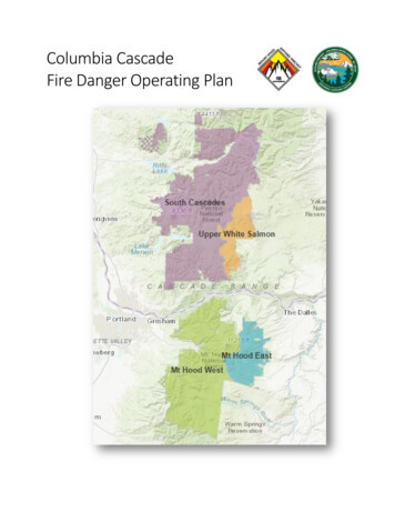
Fire Danger Rating AreasA Fire Danger Rating Area (FDRA) is defined as alarge geographic area relatively homogenous withrespect to climate, vegetation and topography.Because of these similarities, it can be assumedthat the fire danger within a FDRA is relativelyuniform. Fire Danger Rating Areas were delineatedbased upon an analysis of these three factors:climate (blue) vegetation (green), and topography(brown). After these environmental factors wereconsidered, the draft FDRAs were edge-matched toFigure 4. FDRA Delineations: climate(blue),vegetation(green), and topography(brown)existing features. It is important that existingResponse Areas are not split by FDRAs; aResponse Area must not have two FDRAs to avoidadditional workload and confusion for operationalpersonnel. FDRAs on the Gifford Pinchot are SouthCascades and Upper White Salmon. FDRAs on theMt Hood are Mt Hood West and Mt Hood East.Figure 5. Final Fire Danger Rating Areas12
Fire Danger Decision AnalysisDecision points can be based upon either: Climatological Breakpoints, or Fire Business Thresholds.This Fire Danger Operating Plan will be used to support preparedness, staffing and response decisionswhich are made at specific decision points. A “decision point” is a point along the range of possibleoutput values where a decision shifts from one choice to another. When the combination of events andconditions signal that it is time to do something different, a “decision point” has been identified for eachFire Danger Rating Level within each Fire Danger Rating Area.A.CLIMATOLOGICAL ANALYSISClimatological breakpoints are points on the cumulative distribution curve of one fireweather/danger index computed from climatology (weather) without regard for associated fireoccurrence/business. For example, the value at the 90th percentile ERC is the climatologicalbreakpoint at which only 10 percent of the ERC values are greater in value.It is equally important to identify the period or range of data analysis used to determine theagency percentiles. The percentile values for the calendar year (Jan – Dec) will be different fromthe percentile values for the fire season (Jun – Sept). Each agency will have specific (andperhaps different) direction for use of climatological percentiles.The decision thresholds identified in this Fire Danger Operating Plan are based upon thestatistical correlation of historical fire occurrence and weather data and, therefore, do notutilize climatological (percentiles) for decision points.B.FIRE BUSINESS ANALYSISIn order to apply a fire danger system which will assist managers with fire managementdecisions, ignition problems should be identified, quantified, framed, and associated with atarget group to determine the most appropriate fire danger-based decision “tool” to mitigateany given issue.The Mt Hood East, Mt Hood West, and South Cascades FDRAs utilize fire business analysis.Climatological analysis was used on in the Upper White Salmon FDRA due to limited fire data andweather data.The following table provides a summary of the planning area’s ignition problems and concerns. Inaddition, each problem is associated with a specific target group whose activities can be influencedthrough effective communication and implementation of specific control measures. This table is alsoavailable as it applies to each FDRA in Appendix A.13
Table 2. Problem fire ControlLowGeneralTargetGroupPublicSpecific
Provide a tool for agency administrators, fire managers, dispatchers, and firefighters to correlate fire danger ratings with appropriate fire business decisions in fire danger planning area. 2. Delineate fire danger rating areas (FDRAs) in fire danger planning area with similar climate, vegetation, and topography. 3.