Transcription
LAGRANGE AND ROBINSON CREEKSGrowing Area # 028Middlesex CountyShoreline Sanitary SurveyDate: 5 January 2012Survey Period: April 1 – October 21, 2011Total Number of Properties Surveyed: 471Surveyed By: W.A. McCartySECTION A: GENERALThis survey area extends from Reference Point 29 at Corbin Hall Road extended at GoosePoint to Reference Point 30 at Rappahannock Avenue in the town of Urbanna, including theRappahannock River shoreline between these two points, Lagrange Creek (South Branch),Robinson Creek, Perkins Creek, and all of their tributaries.The area is characterized by elevations that rise sharply from the shoreline adjacent to theRappahannock River and its tributaries to approximately 20’ and then level out to form plateauareas that extend inland. The population is relatively sparse throughout most of the surveyarea, with some greater density occurring along portions of the Rappahannock River shorelineand the shorelines of the area’s creeks. The US Census Bureau reported that the population ofMiddlesex County showed an increase of 10.3 % between 2000 and 2010. The economy of thearea is dependent mainly upon agriculture with the seafood industry and recreation also ofimportance.Meteorological data indicated a total of 34.61” of rain fell during the survey period. This totalincludes the rains from the remnants of both Hurricane Irene in late August and Tropical StormLee in September. A monthly breakdown of rainfall is as follows:April, eptember11.0”6.51”October 1-212.31”A portion of the town of Urbanna that is within growing area 28, a portion of Beth-Pagecampground, and the subdivisions of Kilmer’s Point and Cedar Point are served by sewagetreatment plants. Only the plant that serves Kilmer’s Point and Cedar Point discharges withinArea 28, and consequently the engineering appendix contains information dealing only with thisplant.The Commonwealth of Virginia, under Code Section 9VAC 10-20-120.7, specifies that on-sitesewage treatment systems not requiring a Virginia Pollutant Discharge Elimination System(VPDES) permit shall:a. Have pump-out accomplished for all systems at least once every five years.
Shoreline Survey # 028Page 2(1) If deemed appropriate by local health department and subject to conditions the localhealth department may set, local governments may offer to the owners of suchsystem, as an alternative to the mandatory pump-out, the option of having a plasticfilter installed and maintained in the outflow pipe from the septic tank to filter solidmaterial from the effluent while sustaining adequate flow to the drainfield to permitnormal use of the septic system. Such a filter should satisfy standards established inthe Sewage Handling and Disposal regulations (12VAC5-610) administered by theVirginia Department of Health.(2) Furthermore, in lieu of requiring proof of septic tank pump-out every five years, localgovernments may allow owners of on-site sewage treatment systems to submitdocumentation every five years, certified by a sewage handler permitted by VirginiaDepartment of Health, that the septic system has been inspected, is functioningproperly, and the tank does not need to have the effluent pumped out of it.Information about Middlesex County can be found on the county website at:www.co.middlesex.va.com.Found during the survey were 1 STF facilities, 2 on-site deficiencies, 3 properties marked aspotential deficiency, 1 industrial site, 1 solid waste site, 8 boating activity sites, and 4 sitesmarked for animal pollution.Copies for Bacteriological, Hydrographic and Shellfish closure data are available at the WhiteStone office for review. Copies of the current condemnation notices and maps are available viathe internet at http://www.vdh.virginia.gov/shellfish.This report lists only those properties that have a sanitary deficiency or may have otherenvironmental significance. DIRECT indicates that the significant activity or deficiency mayhave a direct impact on shellfish waters. Individual field forms with full information on propertieslisted in this report are on file in the Richmond office of the Division of Shellfish Sanitation andare available for reference until superseded by a subsequent survey of the area. Data in thereport is also made available to local health departments and other agencies to address itemsthat may be out of compliance with their regulatory programs.SECTION B: SEWAGE POLLUTION SOURCESSEWAGE TREATMENT FACILITIES11.Kilmer’s Point Homeowners Association, Ms. Barbara Gill, manager, PO Box 148,Urbanna 23175. Permit # VPA01409. Sewage treatment plant for homeownersbelonging to the Kilmer’s Point Association (i.e., residents of Kilmer’s Point and CedarPoint communities). System includes high pressure and low pressure pumping stations,grinders, in-line bar screen, 2 aeration lagoons, a polishing/holding pond, and a chlorinecontact tank. Treated water is piped to a 14-acre site and periodically applied to the fieldby a rolling sprayer. The engineering appendix is comprised of the Department ofEnvironmental Quality’s March 4, 2011 inspection report.ON-SITE SEWAGE DEFICIENCIES2.CONTRIBUTES POLLUTION (Kitchen or Laundry Wastes) – Location: 121 GaylesRoad, Urbanna 23175. Dwelling – white vinyl siding 2 story with green shutters. 2persons. Kitchen sink drains onto ground beside the house. Sanitary notice issued 4-82011 to Field # 32.
Shoreline Survey # 028Page 38.CONTRIBUTES POLLUTION (Kitchen or Laundry Wastes) – Location: 230 Burch Road,Urbanna 23175. Dwelling – brown aluminum siding 1 story with black shutters. Nocontact. Kitchen sink drains onto ground behind the house. Sanitary notice issued 6-1711 to Field # 171. Repair was completed before the conclusion of the survey.POTENTIAL POLLUTION7.Location: 85 Waters End Lane, Water View 23180. Dwelling – tan wood siding 1½ storywith white trim. No contact. Four inch white PVC pipe empties through bulkhead to theRappahannock River. No evidence of pollution at time of inspection.10.Location: 56 Flats Road, Urbanna 23175. Dwelling – grey block 1 story with white trim.2 persons. Owner states that the privy fills when there is heavy rain. Privy was fine attime of survey.15.Location: 3281 Old Virginia Street. Dwelling – white frame 2 story with green metalroof. No contact. 1½” PVC vent pipe has a broken elbow as it comes out from underthe house. Pipe was not leaking at time of survey.SECTION C: NON-SEWAGE WASTE SITESINDUSTRIAL WASTES17.DIRECT – Shores and Ruark Seafood, Urbanna 23175. Business – oyster shucking (VA294 SP) and crab picking (VA 113 C) plant. Shellfish processing and packing wastewater discharge directly to Robinson Creek pursuant to a permit issued by theDepartment of Environmental Quality permit number # VAG 527058.SOLID WASTE DUMPSITES5.Middlesex Metals, Inc., 2095 Old Virginia Street, Urbanna 23175. Scrap metal recyclingplant. Approximately 5 acres of scrap ferrous and non-ferrous metal on the property.Activity at this site includes receiving, dismantling, sorting and packaging material forshipment to buyers of scrap metal. The plant operates under permit number VAR540251.SECTION D: BOATING ACTIVITYMARINAS6.Remlik Marina, 485 Burch Road, Urbanna 23175. J. Douglas Jackson, President.Commercial Marina. Available on-site are 85 seasonal slips/moorings, 40 dry storagespaces, ramp, fuel, water, electric, solid waste containers, restrooms, dump station, andsewage holding tank pump-out facilities.12.Kilmer’s Point Subdivision # 2, Kilmer Point Drive, Urbanna 23175. Owner: Kilmer’sPoint Homeowner’s Association. No contact. Available on-site are 36 seasonalSlips/moorings, water, electricity, restrooms, and a dump station.16.Sunset Point Marina, 792 Burrell Marina Road, Urbanna 23175. Owner: WalesaCorporation. Commercial Marina. Available on-site are 41 seasonal slips/moorings, 20dry storage spaces, ramp, water, electric, solid waste containers, restrooms, dumpstation, and sewage holding tank pump-out facilities.
Shoreline Survey # 028Page 417.Shores and Ruark Seafood, 453 Johnson Drive, Urbanna 23175. Owner: Rufus RuarkJr. Oyster (VA 294 SP) and crabmeat (VA 113 C) plant. Available on-site are 5 seasonalslips/moorings, fuel, water, electric, restrooms, and a dump station.18.Bethpage Camp Resort, 679 Browns Lane, Urbanna 23175. Owner: Walter B. Hurley.Campground. Available on-site are 201 seasonal slips/moorings, 200 dry storagespaces, ramp, water, electric, solid waste containers, restrooms, dump station, andsewage holding tank pump-out facilities.OTHER PLACES WHERE BOATS ARE MOORED7.Location: 288 Burch Road, Urbanna 23175. Owner: Thomas Bristow. Private pier.Available on-site are 6 seasonal slips/moorings, water, electric, and a restroom.UNDER SURVEILLANCE13.Kilmer’s Point Subdivision # 1, Remlik Drive, Urbanna 23175. Owner: Kilmer’s PointHomeowner’s Association. No contact. Available on-site is a community boat ramp anda loading/unloading dock.14.Remlik Hall, Apple Blossom Lane, Urbanna 23175. Owner: Kilmer’s Point Homeowner’sAssociation. No contact. Available on-site are 4 seasonal slips/moorings.SECTION E: CONTRIBUTES ANIMAL POLLUTION1.DIRECT – Location: 2944 Corbin Hall Drive, Urbanna 23175. Present at time of surveywere 50 cows. Cows roam within 100 feet of Lagrange Creek. Manure is left in fields.3.Location: 949 Gayles Road, Urbanna 23175. Present at time of survey were 2 emus, 1pig, 6 goats, 1 horse, 1 donkey, 10 chickens, and 6 ducks. Manure is left on ground.4.Location: 1755 Gayles Road, Urbanna 23175. Present at time of survey were 16horses. Manure is left in pasture.9.Location: 521 Sunderland Creek Road, Urbanna 23175. Present at time of survey were150 cows. Cows do not get closer than 150 feet to Lagrange Creek. Manure is left inpasture.
Shoreline Survey # 028Page 5SUMMARYGrowing Area # 028Lagrange and Robinson Creeks5 January 2012SECTION B: SEWAGE POLLUTION SOURCES1. SEWAGE TREATMENT FACILITIES0 – DIRECT – None1 – INDIRECT – # 111 – B.1. TOTAL2. ON-SITE SEWAGE DEFICIECIES – Correction of deficiencies in this section is theResponsibility of the local health department.0 – CONTRIBUTES POLLUTION, DIRECT – None0 – CONTRIBUTES POLLUTION, INDIRECT – None0 – CP – (Kitchen or Laundry Wastes) – DIRECT – None2 – CP – (Kitchen or Laundry Wastes) – INDIRECT – # 2, 80 – NO FACILITIES – DIRECT – None0 – NO FACILITIES – INDIRECT – None2 – B.2. TOTAL3. POTENTIAL POLLUTION – Periodic surveillance of these properties will be maintained todetermine any status change.3 – POTENTIAL POLLUTION – # 7, 10, 15SECTION C: NON-SEWAGE WASTE SITES1. INDUSTRIAL WASTE SITES1 – DIRECT – # 170 – INDIRECT – None1 – C.1. TOTAL2. SOLID WASTE SITES0 – DIRECT – None1 – INDIRECT – # 51 – C.2. TOTALSECTION D: BOATING ACTIVITY5 – MARINAS – # 6, 12, 16, 17, 181 – OTHER PLACES WHERE BOATS ARE MOORED – # 72 – UNDER SURVEILLANCE – # 13, 148 – D. TOTALSECTION E: CONTRIBUTES ANIMAL POLLUTION1 – DIRECT – # 13 – INDIRECT – # 3, 4, 94 – E. TOTAL
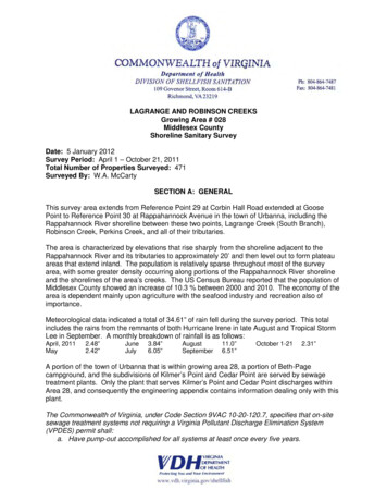
76 39'0"W76 38'0"W76 37'0"W76 36'0"W76 35'0"WVirginia Department of HealthDivision of Shellfish Sanitation27-2Lagrange and Robinson Creeks# 028Shoreline Sanitary SurveyMiddlesex CountyDate: 5 January 2011Survey By: W.A. McCarty IIINumber of Properties Surveyed: 4715001,000Yards37 41'0"N37 41'0"N042128-1438728-1328-12628-112937 40'0"N28-1028-937 171528-5A28-4.528-41628-337 39'0"N1837 39'0"N28-3.528-228-2.53037 38'0"NGeographic coordinates in NAD83 datum;shown in degrees, minutes & seconds.76 39'0"W76 38'0"W76 37'0"W76 36'0"W76 35'0"W
A portion of the town of Urbanna that is within growing area 28, a portion of Beth-Page campground, and the subdivisions of Kilmer's Point and Cedar Point are served by sewage . www.co.middlesex.va.com. Found during the survey were 1 STF facilities, 2 on-site deficiencies, 3 properties marked as potential deficiency, 1 industrial site, 1 .