Transcription
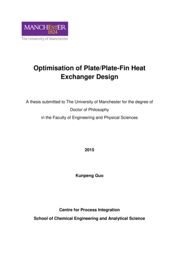
Reviewed research articlePlate boundaries, rifts and transforms in IcelandPáll EinarssonInstitute of Earth Sciences, University of Iceland, Sturlugata 7, 101 Reykjavík, Iceland palli@hi.isAbstract – The Iceland hotspot has a pronounced effect on the appearance and structure of the plate boundarybetween the North America and Eurasia Plates that crosses the island. The thick crust produced by the excessmagmatism of the hotspot leads to a wider and more complicated plate boundary deformation zone than isobserved along normal oceanic plate boundaries. Furthermore, the relative movement of the boundary with respect to the roots of the hotspot leads to unstable boundaries and rift jumps, when crustal blocks or microplatesare transferred from one major plate to the other. The plate boundary zone can be divided into segments thatare physiographically relatively homogeneous and possess distinct tectonic characteristics. The segments aremore or less oblique to the relative spreading direction of the two major plates. The divergent component of themovements is taken up by diking and normal faulting and is usually concentrated in the fissure swarms of thevolcanic systems. The transcurrent component of the movements is often accommodated by strike-slip faultingon faults that are transverse to the plate boundary segment, so-called bookshelf faults, witnessing to the transient nature of the segments. In highly oblique segments, such as the Reykjanes Peninsula Rift and the GrímseyOblique Rift, both types of active structures occur superimposed on each other. In the South Iceland SeismicZone, that is almost parallel to the local spreading direction, the bookshelf faults dominate the structure, producing earthquakes as large as magnitude 7. More mature transform zones, such as the Húsavík-Flatey faults,have developed strike-slip faults that are sub-parallel to the plate movements. The activity on this transformzone, however, appears to be declining because of transfer of movement over to the Grímsey zone. This issupported by the lack of Holocene volcanism along the Eyjafjarðaráll Rift that connects the transform to theKolbeinsey Ridge plate boundary off shore. A ridge-jump appears to be in progress in South Iceland, whererifting is occurring in two sub-parallel rift zones, the very active Eastern Volcanic Zone and the less activeWestern Volcanic Zone. The block between them is seismically and volcanically inert and may be defined asa microplate, the Hreppar Microplate. It is rotating in response to the southward propagation of the EasternVolcanic Zone and corresponding recess of the Western Volcanic Zone. Poles of relative rotation with respect tothe North America and Eurasia Plates are suggested near 65.2 N, 20.1 W, and 62.8 N, 21.3 W, respectively.INTRODUCTIONIceland is a platform of dimensions 300x500 km situated astride a divergent plate boundary and on top ofa hotspot presumed to be fed by a deep mantle plume(Einarsson, 1991a, 2001). This land platform is onlya part of a much larger platform, also comprising theshelf area, 450 x 750 km wide and bounded by a welldefined shelf edge. The eastern part of this mass sitson the Eurasia Plate and the western part sits on theNorth America Plate.The mid-Atlantic plate boundary is relatively simple in most parts of the NE-Atlantic, consisting of rifting and transform segments separating the two majorplates, Eurasia and North America. The boundary isclearly defined by the epicenters of earthquakes thatshow a narrow zone of deformation (Figure 1). Asit crosses the Iceland platform, however, the deformation zone becomes wider, as shown by the distributionof earthquakes and volcanism in Figure 2. The boundary breaks up into a series of more or less obliqueJÖKULL No. 58, 200835
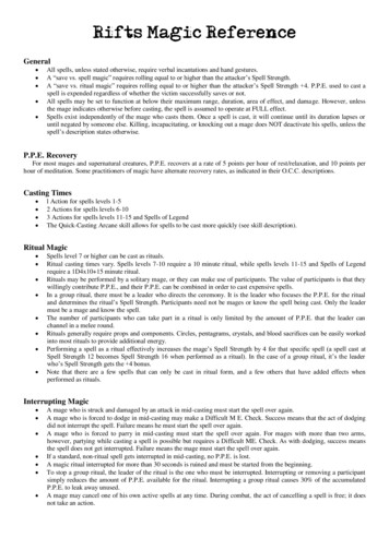
Páll EinarssonFigure 1. Earthquake epicenters in the Atlantic Ocean 1964–2006. Data are from the epicentral list of theNEIC, US Geological Survey. – Upptök jarðskjálfta á Atlantshafssvæðinu umhverfis Ísland 1964–2006. Byggtá gögnum frá Jarðfræðistofnun Bandaríkjanna.segments. In some places the boundary branches outand small microplates or tectonic blocks are formedthat may move independently of the large plates. TheHreppar and Tjörnes blocks are the clearest examples.Both of them seem to move mostly with the NorthAmerica Plate at the present time. Most of these com-36 JÖKULL No. 58, 2008plexities have been attributed to the presence of theIceland Plume even though the causal relationship isby no means clear. The center of the plume is generally assumed to be located under Central Iceland (e.g.Wolfe et al., 1997). The tectonic fabric and style ofdeformation along the different segments is largely
Iceland rifts and transformsFigure 2. Earthquake epicenters 1994–2007 and volcanic systems of Iceland. Volcanic systems and active faultsare from Einarsson and Sæmundsson (1987). Epicenters are from the data bank of the Icelandic Meteorological Office. Individual plate boundary segments are indicated: RPR Reykjanes Peninsula Rift, WVZ WesternVolcanic Zone, SISZ South Iceland Seismic Zone, EVZ Eastern Volcanic Zone, CIVZ Central Iceland VolcanicZone, NVZ Northern Volcanic Zone, GOR Grímsey Oblique Rift, HFZ Húsavík-Flatey Zone, ER EyjafjarðarállRift, DZ Dalvík Zone. SIVZ South Iceland Volcanic Zone. Kr, Ka, H, L, V mark the central volcanoes of Krafla,Katla, Hengill, Langjökull, and Vestmannaeyjar. – Upptök jarðskjálfta 1994–2007, misgengi og eldstöðvakerfiá Íslandi. Skjálftaupptök eru fengin frá Veðurstofu Íslands.determined by the length of the plate velocity vector and its degree of obliqueness along the segment.Some segments are purely divergent. In these segments normal faulting and fissuring are the main typesof fracturing and volcanism is pervasive as seen inthe Northern Volcanic Zone (NVZ) in North Icelandand the two sub-parallel rift zones in South Iceland,the Western and the Eastern Volcanic Zones (WVZJÖKULL No. 58, 200837
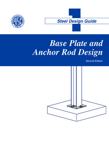
Páll Einarssonand EVZ). Other segments are conservative, i.e. areof transform type, such as the South Iceland SeismicZone (SISZ) and the Húsavík-Flatey Zone (HFZ) inNorth Iceland. Strike-slip faulting is dominant andvolcanism insignificant. Oblique segments containvolcanism and strike-slip tectonism in close proximity to each other. The Reykjanes Peninsula Rift (RPR)and the Grímsey Oblique Rift (GOR) are examples ofthis type. There is some evidence that the two modesof deformation alternate with time.This paper gives an overview of the structuralcharacteristics of the the plate boundary segments ofIceland. In most cases these characteristics are consistent with the orientation of the segments with respect to the plate separation vector. Exceptions areseen in South Iceland. Most of the discrepancies can,however, be explained by assuming the Hreppar blockis a microplate that rotates with respect to the NorthAmerica Plate around a pole north of Langjökull.THE RELATIVE MOVEMENTS OF THEMAJOR PLATESThe pole of relative rotation between the two majorplates is located in NE-Siberia at 62.4 N and 135.8 E,and the relative rotation speed is 0.21 per millionyears according to the Nuvel-1A model of plate motions (DeMets et al., 1994). Holding the North America Plate fixed this gives a plate velocity vector of18.2 mm/year in a direction of 105 for Central Iceland, slightly faster and more easterly for South Iceland, slightly slower and more southerly for NorthIceland. This velocity is valid for the last few millionsof years, the time scale of the magnetic and structuraldata used to constrain the Nuvel-1A model. GPSdata from the continuously recording stations (Figure 3) give results that are consistent with the Nuvel1A velocity (Geirsson et al., 2006), also results ofmeasurements of the country-wide ISNET network in1993 and 2004 (Árnadóttir et al., this volume; Geirsson et al., 2005) as well as the results from globallydistributed GPS-stations (Sella et al., 2002). Thisdemonstrates that the plate movements are consistent on time scales ranging between years and million years. An example of the constant rate of move-38 JÖKULL No. 58, 2008ments is shown in Figure 3, the time series 1999–2008for the continuous GPS-station at Höfn in SE-Iceland.When the annual cycle caused by snow load on thehighlands (Grapenthin et al., 2007) and the co-seismiceffect of the June 2000 earthquakes in South Icelandon the reference station in Reykjavík have been removed, the graphs shows virtually straight lines. Theslopes of the lines give an eastward component of22.1 mm/year and a southward rate of 3.9 mm/year.The vector therefore has a magnitude of 22.4 mm/yearand a direction of 100 .PLATE BOUNDARY DEFORMATIONZONEBetween the major plates there is a zone of deformation where the crustal movements are different fromthat of the plates. The width of this deformation zoneis somewhat variable. In Northern Iceland it is about100 km wide and coincides more or less with thezone of Holocene volcanism and fissuring. The plateboundary deformation zone accumulates strain duringtime intervals between significant failure events suchas rifting episodes or larger earthquakes. Such gradualaccumulation has been documented for the EVZ byJónsson et al. (1997), across the SISZ (Sigmundssonet al., 1995; Alex et al., 1999), and along the Reykjanes Peninsula oblique rift by Sturkell et al. (1994),Hreinsdóttir et al. (2001), and Keiding et al. (2007).In Southern Iceland the plate boundary has twobranches and the block between them does not showevidence of active deformation or volcanism. Earthquake epicenters are almost completely lacking (Figure 2). This block appears to fulfill the criteria ofa microplate and has been termed the Hreppar Microplate. The southern boundary of the Hreppar Microplate is marked by the South Iceland Seismic Zonewhere large, strike-slip earthquakes occur. The northern boundary is marked by diffuse volcanism of theCentral Iceland Volcanic Zone (CIVZ) and the relative movement across it seems to be slow.It has been a matter of considerable debate howthe plate movements in South Iceland are partitionedbetween the two parallel rift zones, the Western Volcanic Zone and the Eastern Volcanic Zone. It is gen-
Iceland rifts and transformsFigure 3. Velocities of the continuous GPSstations Höfn (HÖ), Skrokkalda (SK), and Ísakot(IS) with respect to Reykjavík (RE) shown as fatarrows. Thin arrows show the calculated velocity of the Eurasia Plate with respect to the NorthAmerica Plate according to the Nuvel 1 model.Time-series of the displacements of the station ofHöfn with respect to Reykjavík is shown (datafrom Halldór Geirsson, Icelandic MeteorologicalOffice). Index map shows the plate boundaries.The velocities of the stations SK and IS are 3mm/a in direction 50 and 5 mm/a in direction70 , respectively. – Rekhraði á samfelldu GPSmælistöðvunum á Höfn í Hornafirði (HÖ), Skrokköldu (SK) og Ísakoti (IS) reiknaður miðað viðReykjavík. Þunnu örvarnar sýna rekhraðann áEvrasíuflekanum miðað við Norður-Ameríkuflekann reiknaðan eftir Nuvel-1-líkaninu fyrir flekareká jörðinni. Einnig er sýnd færsla sem fall af tímafyrir stöðina á Höfn í Hornafirði, reiknuð miðað við stöðina í Reykjavík. Kortið sýnir flekaskilin á Íslandi. Hraði stöðvanna tveggja sem eru áHreppaflekanum er: Skrokkalda 3 mm/ári í stefnu50 og Ísakot 5 mm/ári í stefnu 70 .erally assumed that the two zones are the expressionof a ridge jump, i.e. that the WVZ is a dying riftthat is being replaced by the currently much moreactive EVZ (e.g. Einarsson, 1991a). The question iswhether the ridge jump occurs by rift propagation,i.e. the EVZ propagating towards the SW while theWVZ recedes, or by activity alternating between therifts (Sigmundsson et al., 1995) and the whole WVZgradually becoming less active. The lack of evidencefor rotated structures within the Hreppar Microplatehas been evoked to support the latter hypothesis. Recent modeling studies of GPS data, however, appearto support rotational movements of the Hreppar Microplate (La Femina et al., 2005), which is in favourof the propagating rift hypothesis. The model resultsindicate that near the Hengill triple junction as muchas 35% of the plate movements is taken up by theWVZ. This proportion dies out towards the NE andis less than 10% in the Langjökull region. This mustindicate a counter-clockwise rotation of the HrepparJÖKULL No. 58, 200839
Páll EinarssonMicroplate, considering the lack of evidence for significant irreversible internal deformation of that plate.TECTONIC STRUCTURE OF THEPLATE BOUNDARY SEGMENTSThe plate boundary in Iceland can be divided into segments, each with its tectonic and magmatic characteristics and properties. Different authors have used different schemes for the division and there is considerable confusion in the use of names in the literature. Inthe following text we attempt to clarify this situation.Crustal formation occurs by magmatism in zonesof divergence. Most of the activity is linked with volcanic systems, about 25 of which have been identified on land and 10 more in the shelf areas to thenorth and south. A volcanic system is defined from itsstructural and petrologic characteristics (Sæmundsson, 1978; Jakobsson, 1979a,b). It consists of a central volcano and a fissure swarm that transsects it in adirection nearly normal to the local spreading direction. The magmatic activity has a maximum in thecentral volcano, most of it basaltic but it may contain acidic rocks as well (Walker, 1993). Sometimescalderas develop in the central volcano and most alsohave geothermal systems. The central volcanoes seldom reach high elevation. Loading of the crust by volcanic production is compensated by subsidence of theweak and warm crust. The volcano therefore growsdownwards more than upwards. The fissure swarmsare 5–20 km wide and from a few tens to more than100 km long. They often have the structure of a gentlegraben bounded by normal faults of small throw. Thevolcanic systems are arranged side-by-side in some o
Reviewed research article Plate boundaries, rifts and transforms in Iceland Páll Einarsson Institute of Earth Sciences, University of Iceland, Sturlugata 7, 101 Reykjavík, Iceland palli@hi.is Abstract– The Icelandhotspothasa pronouncedeffecton theappearanceandstructure ofthe plateboundary between the North America and Eurasia Plates that crosses the island.