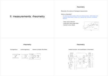
Transcription
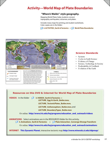
Activity—World Map of Plate Boundaries“Where’s Waldo”-style geography.Mapping World Plates helps students connecttopography, earthquakes, volcanoes, and plates.Includes many maps for printing, and student worksheets.Color copies are in the folder:4. ACTIVITIES Earth & Tectonics World Plate BoundariesScience Standards PLATE BOUNDARIESDivergent marginConvergent marginTransform fault (arrowsshow relative motion)Most of the world’s earthquakes and volcanoes arefound at or near the boundary between two tectonicplates. Friction between the plates keeps them fromsliding. When the frictional strain is overcome, theground suddenly snaps along faults and fracturesreleasing energy as earthquakes. Volcanoes occur atdivergent margins (where magma rises and erupts);at convergent margins (where an oceanic platedives beneath another plate; magma forms in thecontinental plate above the diving oceanic plate),and less commonly as hot spots (where magmamelts through a plate, such as Hawai i).SystemsCycles in Earth ScienceEvidence of ChangeScience, Technology & SocietyPredictability & FeedbackEvolution of the EarthSYMBOLSWhite arrows show plate motion directionVolcanoes (generalized)Hot spot (arrow direction of plate motion)Great earthquakes since 1900;before 1900Resources on this DVD & Internet for World Map of Plate BoundariesVIDEOS: In the folder3. VIDEOS Earth & Tectonics LECTURE Egg Vs Earth Butler.mov,LECTURE TectonicPlates Butler.mov,LECTURE Asthenosphere Butler.mov, andLECTURE BoundaryTypes Butler.movOr online: http://www.iris.edu/hq/programs/education and outreach/videosANIMATIONS: Select animations are in the RESOURCES folder for this activity.3. Animations Earth & Tectonics Plate Interaction Converge Diverge TransformOr online: http://www.iris.edu/hq/programs/education and outreach/animationsINTERNET: This Dynamic Planet, interactive tectonic map http://www.minerals.si.edu/tdpmap/e-binder for 2013 CEETEP workshop69
World Map of Plate BoundariesIntroductionThe Plate Tectonics Mapping Activity allows students toeasily begin to identify basic tectonic processes on a globalscale. As students become aware of plate movements,they begin to identify patterns that set the stage for deeperunderstanding of a very complex topic. The activity usesa simple “Where’s Waldo” approach to identify tectonicsymbols on a laminated World Plate Tectonic map.MaterialsObjectivesMaps—The map on the next page is offered in severalformats for classroom use. Since not everyonehas access to a large-format printer we offer theposter as a 3-page, tabloid-size pdf file that canbe printed and taped together. The maps are alsooffered WITHOUT tectonic boundaries to beused to see if students recognize features in thelandscape.Learn where volcanoes and earthquakes occurUnderstand geographyUse critical thinking to find plate boundariesAnswer relevant discussion questions on worksheetProcedurePrint the appropriate maps (see Materials) for use. Notethat the maps in this document need to printed on legal-sizepaper!!Students work in pairs or small groups of 3 or 4 studentsusing washable markers to circle tectonic features. Thishands-on activity captures the interest of all ability levels.The process of exploring the map and drawing with coloredmarkers captures student interest and creates curiosity todiscover why particular features are located where they are.As students work through simple questions on the activitysheet, they are then able to start the more challengingprocess of understanding the patterns and process that makeup the fundamental principles of Plate Tectonics.The Discussion Questions in the activity are providedas a resource for teachers to engage student’s growingunderstanding. The questions have been used in smallgroups, whole class discussion, research, as a writingassignment, and for evaluation.70Discussion Questions —On page 7.Student work sheets—Begin on page 5 of thisdocument; answers follow.Word files of the worksheets are in the folderRESOURCES For World Plate Boundaries Word Docs for World Plate Boundaries1) Page size (next page) and on DVD in the folder:RESOURCES For World Plate BoundariesMaps for printing WorldTectonicMap PageSize.pdf.2) Poster (14x24) requires a plotter to printWorldTectonicMap POSTER 14x24.pdf3) Poster (tabloid-size pages to be taped together)WorldTectonicMap-Poster 3page11x17.pdf4) WITHOUT tectonic features to be used to see iftectonic features show up in the landscape:WorldTectonicMap NoBoundaries8.5x14.pdf.WorldTectonicMap NoBoundaries11x17.pdf.
e-binder for 2013 CEETEP workshop71Transform fault (arrowsshow relative motion)Convergent marginDivergent marginPLATE BOUNDARIESMost of the world’s earthquakes and volcanoes arefound at or near the boundary between two tectonicplates. Friction between the plates keeps them fromsliding. When the frictional strain is overcome, theground suddenly snaps along faults and fracturesreleasing energy as earthquakes. Volcanoes occur atdivergent margins (where magma rises and erupts);at convergent margins (where an oceanic platedives beneath another plate; magma forms in thecontinental plate above the diving oceanic plate),and less commonly as hot spots (where magmamelts through a plate, such as Hawai i).before 1900Great earthquakes since 1900;Hot spot (arrow direction of plate motion)Volcanoes (generalized)White arrows show plate motion directionSYMBOLS
Divergent Boundaries & Spreading ZonesSpreading center—FastDivergent boundaries occur mostlyalong spreading centers where themagma rises forming new crust.(Ex. East Pacific Rise, Mid AtlanticRidge.)Spreading center—SlowMountains & valleysO ce a n i c c r u s tL ithosphereM a nt l eAsthenospherePartial meltSpreading zones (no graphic) oncontinents create parallel mountainsand valleys as the crust pulls apart(ex: Basin & Range, U.S. and theCrustLithosphereMantleAsthenospherePartial meltGreat Rift Valley, Africa. )Convergent BoundariesLithosphereOceanic crustOceanAsthenosphereiccrusL i t h o s p h e reL i t h o s p h e reLi th o sp h e re.Ast h e n o s p h e reCo nt i n e nt a l c r u s tCo nt i n e nt a l c r u s tCo nti n e ntalc ru s t. . . . . . .L i th o sp h e reAsthenosphereHighPl ate a uMouR an t a i nngeVo lc an icar cchenCo n t i n e n t a lcrustcrustOceanicLithosphereTrTrenchIs la ndar cWhen two plates move toward each other, crust is destroyed as one plate dives (is subducted) beneaththe other. The location where sinking of a plate occurs is called a subduction zone.OAs t h e n o s p h e re. . .ldocetOcean-Ocean—Ocean plate divesbeneath another ocean plate;volcanic island chain forms abovethe zone (ex:. The Marianas)Ocean-Continent: Ocean plate divesbeneath a continental plate. Volcanicmountain chain forms inland.(ex:. Cascade Range, Sumatra, Japan)aniccrCrustLithosphereAsthenosphereStrike slip faults result fromtwo plates moving horizontallyin opposite directions(ex: San Andreas Fault, California).72stContinent-Continent: Two thickcontinental plates collide and buckleinto high mountains.(ex: Himalaya Mountain Range.)Transform BoundariesAs surrounding platesare driven by deep forcesto move apart or crunchtogether, the in-betweenareas are pushed aroundon the surface. This forcesthem to slide past eachother horizontally.uSpreadingridgeTra n s fo r m f a ul tSpreadingridgeLithos phereAs thenos phereCrustPartial meltTransform faults are where twoplates are moving away froma spreading ridge and fracturezones develop (ex: ocean floor)
NamePeriod DatePLATE TECTONICS MAPPING ACTIVITY1. Draw the symbol for each tectonic feature in the chart belowDivergent margins and spreading centers (draw in black)Convergent margins - subduction zoneTransform faults – strike-slip faultsHot Spot(draw in blue)(draw in green)(draw in red)2. Use the correct color of washable marker to locate each tectonic feature on the map.a. Circle the name of the Divergent boundary systemsin black. (Ridges and Rises)Number foundb. Circle the Convergent margins in blue.(students may circle individual trenches)c. Circle the Transform fault symbols (and theirfaults) in green.Number foundNumber foundd. Circle the Hot Spots in red.Number found3. What is the name of the small crustal plate off the Oregon coast that is subductingunder the North American plate?4. Where are most of the earthquakes and volcanoes located?Check one: a. crustal plate marginsb. interior of a crustal plateAnswer the following questions about Plate Tectonic Processes using the diagrams with the map.5. Divergent margins and continental spreading centers:a. New crust forms at plate margins as rises creating ridges underoceans such as the and the .e-binder for 2013 CEETEP workshop73
b. Continental spreading centers include thein the US and the in Africa.6. Convergent margins – subduction zones:Identify the land form (geomorphology) created at each type of Convergent Boundaryand provide an example.a. Ocean-Oceanb. Ocean-Continentc. Continent-Continent7. Transform faults – strike slip faultsa. Sometimes tectonic plates shift past each other horizontallydirections at their boundary.b. One example of a strike slip fault near San Francisco is the .8. Earthquakes:a. Most earthquakes occur near plate .b. keeps the plate edges from sliding smoothly past each other.c. The longer the plates remain stuck, the more strain builds and the more violentthe snap and resulting .9. Volcanoes:a. Magma rises to the surface from inside the earth mainly atand .b. Around the rim of the Pacific Ocean, the 40,000 km long ofis especially active.10. Hot Spots:a. In a few places melts through a tectonic plate.b. Each hot spot likely marks the top of a plume of rock that risesfrom deep in the earth.74
Discussion Questions: (italics are guiding ideas on a few random questions.)Discussion questions can be used in a whole group setting, or selected questions may be assigned to table groupsto answer and then shared with the class.1. Does the location of earthquakes and volcanoes show a pattern? If so, what tectonic process may be responsible?(compression, extension, shearing)2. Generally speaking, where are the oceanic ridges located with respect to the landmasses? (in the middle of the ocean:heavy thin crust sinks and water fills low areas.)3. Where do you find the mountain ranges with respect to the oceanic ridges? Use examples. (the ocean-floor ranges areon the crest of the spreading ridges where heat provides the buoyant lift; they sink as they cool.)4. Are there any places on Earth where the mid-oceanic ridges meet the continent?5. What are seamounts?6. Most of the Pacific Ocean is on what plate?7. What is the compass orientation of the Hawaiian Islands and many of the other smaller ridges within the PacificOcean? Is this significant? (the islands are moving away from the hotspot in the direction the plate is traveling. Thus the lineof the youngest islands is oriented west-northwest as they move towards Japan)8. In what compass direction is the Pacific Plate moving? (see previous question)9. Name the biggest and longest mountain range in the world. What is it? (Trick question. It is a mid-ocean ridge.)10. Name an island chain that has been formed by a “hot spot”. (see question 7 above. The Hawaiian Islands.)11.What island in the North Atlantic Ocean is splitting apart? What is causing the split? (Iceland is a hotspot that isstraddling the Mid-Atlantic spreading ridge. The spreading ridge is causing the split. If it were just a hotspot it would just build abig edifice.)12. Where is magma rising to the surface and forming ocean crust? (At spreading ridges)Where is the oceanic crust sinking back into the mantle? (At subduction zones)13. Some people have referred to the process in the above question as a cycle. Why would it be considered a cycle?(Rock is formed at the spreading ridge; gets destroyed at subduction zones. The subducted rock eventually gets absorbed into themantle and gets caught in the very slow circulation of rock in the mantle which can melt as it rises to the top again.)14. What are the attributes of a cycle?Can you describe another cycle that could compare with the example described above.15. Why is it that the Pacific Ocean floor is no older than about 200 million years and yet the continents are mucholder? (The ocean floor is being created constantly. It is made of heavy rock that tends to subduct when it meets continentalrock. The continents are made of older rock that is more buoyant .16. The continental margins of the East and West Coast of the United States are very different. Describe thedifferences. Are there tectonic differences?17. Where would you expect to find igneous, sedimentary and metamorphic rocks?e-binder for 2013 CEETEP workshop75
Teacher Answer KeyPLATE TECTONICS MAPPING ACTIVITY1. Draw the symbol for each tectonic feature in the chart belowDivergent margins and spreading centers (draw in black)Convergent margins - subduction zoneTransform faults – strike-slip faultsHot Spot(draw in blue)(draw in green)(draw in red)2. Use the correct color of washable marker to locate each tectonic feature on the map.a. Circle the name of the Divergent boundary systemsin black. (Ridges and Rises)Number found 7b. Circle the Convergent margins in blue.(students may circle individual trenches)c. Circle the Transform fault symbols (and theirfaults) in green.Number found 16 Number found 10d. Circle the Hot Spots in red.Number found 53. What is the name of the small crustal plate off the Oregon coast that is subductingunder the North American plate? Juan de Fuca4. Where are most of the earthquakes and volcanoes located?Check one: a. crustal plate margins Xb. interior of a crustal plateAnswer the following questions about Plate Tectonic Processes using the diagrams with the m
a simple “Where’s Waldo” approach to identify tectonic symbols on a laminated World Plate Tectonic map. Objectives Learn where volcanoes and earthquakes occur Understand geography Use critical thinking to find plate boundaries Answer relevant discussion questions on worksheet Procedure Print the appropriate maps (see Materials) for use. Note that the maps in this document need to printed .