Transcription
LABLAB PREP:PREP:Geocoding andAddress MatchingEnvironmental, Earth, &Ocean Science 381- Spring 2015 -
GeocodingThe process by which spatiallocations are determined usingcoordinate locations specified ina database table- Coordinates are expressed as X,Yvalues; Coordinate Systems may beLatitude/Longitude, UTM, State Plane,local, or othersResults can be “events” [points]or “routes” [lines]
Geocoding in ArcGISUse “Geocode Addresses ”in ArcGIS to createfeatures based on a tableof coordinatesRight-click thetable in ArcMapor ArcCatalogSame tool, from menu in ArcMap
Geocoding in ArcGISToolbarToolbox
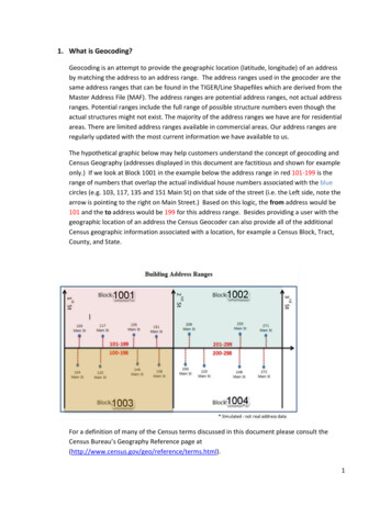
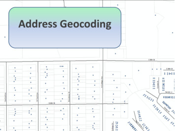
Address Geocoding(aka “Address Matching”)The process by which spatial locations aredetermined (i.e. creating points) using addressesspecified in a database tableAddresses in the database table are matched toaddress ranges specified in a reference spatialdata set (e.g., streets, ZIP codes, parcels,structures)Real world coordinates are assigned to everymatched address, with the real world coordinatesbeing derived from the reference spatial data setAddress-matching is an “interpolative” processand therefore not very precise
RequirementsA table with addressesExample:– Address: Street number and name– Zone: ZIP Code or City/Town, etcThe fields in thetable correlate tothe requirementsof the geocodingengineA reference theme (e.g. streetsegments with address ranges,parcel polygons with address)Software (like ArcGIS, MapInfo,etc.) or a Web service
ProcessEach address is “parsed” intocomponents and the components arecompared with the address ranges inthe reference themeWhen a table address falls within (i.e.matches) the address range of a streetsegment, an interpolation isperformed to locate and assign realworld coordinates to the address (i.e.,“geocode it”)
InterpolationThe coordinate location of the address isestimated using the address ranges of thestreet segmentExample: Let’s say 12 Main Street is theaddress you want to mapSegment ranges:12 Main Street placed here(but could be to the left or right of this in reality)MAIN STREETMAIN STREETFrom/To Left:10-18From/To Right: 11-19MAIN STREET
InterpolationWarning:check youraddresses.There maynot be a 12Main Street.
InterpolationWarning: Actual location may be far frominterpolated point location.100 Morrissey Blvd.(geocoded point location)
Better Reference DataUse reference data with specific addressinformation that does not requireinterpolation.– Parcels– Structures Center Entrance Access32 Glenwood Ave.Parcel centroidBuilding centroidBuilding entranceBuilding access point
Address LocatorsThe first step involves setting up an “AddressLocator” (“GeoCoding Service” in ArcGIS 8.x)An Address Locator contains the following:– path and file name of the reference dataset– rules for standardized descriptions of numbers,names, directions, text, etc. in the reference dataset– parameters for reading address data– parameters for matching address data– parameters for creating output datasetsAddress Locators appear inside folders or atthe top level of geodatabases
Some Address Locator StylesStyleReference Theme TypeUS Streets with ZoneLinesUS StreetsLinesUS Single Range with ZoneLinesUS Single RangeLinesUS Single House with ZonePoints or PolygonsUS Single HousePoints or PolygonsZIP 4PointsZIP 4 RangePoints or PolygonsComposite** Combines existing Locators** Not available in SDE
User Steps - 1Create table of addresses andstandardize the address byparsing into component partsbased on the specified addressstyle– Examine the reference datasetattributes for components that arethe same or similar to thestandardized address
User Steps - 2Create Address Locator (ifnecessary)– Adjust Geocoding Options
User Steps - 3Perform the matching in “batch”modeEvaluate results and interactively“match” individual unmatchedrecords– Or adjust options (in next slide) and redobatch matchSee ArcGIS Help What is geocoding/002500000001000000/
Geocoding OptionsSpelling Sensitivity– how much variation to allow in the matching process– low levels would allow “Main”, “Mane” and “Maine” aspotential candidates for “244 Main St”Score– score from 0 to 100 for each potential candidatebased on matching all address components based onthe chosen geocoding styleMinimum Candidate Score– threshold score from 0 to 100 that allows reportingof potential candidatesMinimum Match Score– rigor specification determining how well address inthe table match reference layer components – ascore of 75 to 100 is a good match
Output OptionsSide Offset– offsets a matched address so many map units to the left orright of the street segment, based on the parity of the matchEnd Offset– applies a “squeeze” factor at ends of line segment to preventpoints from being confused with matches in other streetsegmentsX,Y Coordinates– adds X and Y coordinates in output layer fieldsStandardized Address– adds the standardized address in an output layer fieldReference Data ID– adds the value of the ID of the reference dataset segment inan output layer field [-1 if unmatched]Percent Along– output layer field containing percent distance along referencedataset feature from the “from” node
Data SourcesAddresses:– Company databases, mailing lists– Compile – research, web or paper “yellow pages”– PurchaseReference Data:– Buy it (NavTeq, TeleAtlas, etc.)– Download it free (census.gov, MassGIS, etc.)– StreetMap USA extension to ArcGIS– Create it or pay to create it (from parcel maps, street maps)– MGISDATA.CENSUS2000TIGER ARC in SDE in labCan also use Alternate Name table and an Alias table
Geocoding ApplicationsA company can match customer addressesagainst a street network of their distributorservice areas in order to know whichdistributor will handle a customer. Theinformation could also be used to performmarketing analysis for each service areaA police department could use addressgeocoding to analyze crimes by address.These locations can be mapped and analyzedwith other demographic dataEmergency dispatch operators could usegeocoding to enter an address, determine whoshould respond, and route emergencyvehicles and personnel to the address
Geocoding ApplicationsA school district could use geocoding to matchstudent addresses against a street map of acity. Once the homes of students are located,school assignments and busing plans canbe created and analyzedEnvironmental engineers can identify potentialimpacts of storage facilities for hazardousmaterials in populated areas by matchingthe site addresses to a theme containingcensus dataData development – Create layers like policeand fire stations, schools, town halls, libraries,prisons
Caution, WarningsAddress matching can be a laborious processand is a function of the accuracy of theaddress table and reference theme. Usesoftware’s “batch matching” functionality,then match interactively for those notmatchedAn address table may have typos, incorrectlyspelled street names, blanks, common names,etc., and data can be out-of-date.Some buildings can have “vanity addresses”(e.g. “One Executive Plaza”)
Caution, WarningsMake sure and be prepared tohave a verification process. i.e. agood atlasThe reference data may not bespatially accurate at large scales(like TIGER roads), so resultingpoints may need to be adjustedusing better basemap layers (likeortho imagery)
HelpThe Geocoding 0.2/#/About the Geocoding tutorial/002500000006000000/
Address Geocoding (aka "Address Matching") Address Geocoding (aka "Address Matching") The process by which spatial locations are determined (i.e. creating points) using addresses specified in a database table Addresses in the database table are matched to address ranges specified in a reference spatial data set (e.g., streets, ZIP codes .