Transcription
Stratigraphic Nomenclature of theCentral Santa Monica Mountains,Los Angeles County, CaliforniaGEOLOGICAL SURVEY BULLETIN1457-E
Stratigraphic Nomenclature of theC entral Santa Monica Mountains,Los Angeles County, CaliforniaBy R. F. YERKESawd R. H. CAMPBELLWith a section on AGE OF THE CONEJO VOLCANICSBy D. L. TURNER and R. H. CAMPBELLCONTRIBUTIONS TOGEOLOGICALSURVEYSTRATIGRAPHYBULLETIN1457-EUNITED STATES GOVERNMENT PRINTING OFFICE, WASHINGTON : 1979
UNITED STATES DEPARTMENT OF THE INTERIORCECIL D. ANDRUS, SecretaryGEOLOGICAL SURVEYH. William Menard, DirectorLibrary of Congress Cataloging in Publication DataYerkes, R. F., 1923Stratigraphic nomenclature of the central Santa Monica Mountains, Los AngelesCounty, California.(Contributions to stratigraphy) (Geological Survey Bulletin 1457-E)Bibliography: p. E30-E31.1. Geology, Stratigraphic Tertiary. 2. Geology, Stratigraphic Cretaceous.3. Geology, Stratigraphic Nomenclature California Santa Monica Mountains.I. Campbell, Russell H., 1928- joint author. II. Title. III. Series. IV. Series:United States. Geological Survey. Bulletin 1457-E.QE75.B9 no. 1457-E [QE691]557.3'08s [557.94'93]79-10231For sale by the Superintendent of Documents, U. S. Government Printing OfficeWashington, D. C. 20402Stock Number 024-001-03180-9
CONTENTSPageAbstract ElIntroduction 1Previous work 2Present report 4Stratigraphic nomenclature 4Sequence north of the Malibu Coast fault 4Hina Canyon Formation 4Simi(?) Conglomerate 7Coal Canyon Formation 8Llajas(?) Formation 9Sespe Formation 10Piuma Member 10Vaqueros Formation 11Danielson Member 12San Nicholas Member 12Topanga Group. 13Topanga Canyon Formation 14Topanga Canyon Formation (undivided)15Topanga Canyon Formation (divided) 15Encinal member 15Saddle Peak Member 16Fernwood Member 16Cold Creek Member 17Conejo Volcanics 17Age of the Conejo Volcanics, by D. L. Turner andR. H. Campbell - - -- 18Calabasas Formation 22Modelo Formation24Sequence south of the Malibu Coast fault 25Trancas Formation25Zuma Volcanics 27Monterey Shale 28References cited30ILLUSTRATIONS[Plates are in pocket]PLATE1. History of nomenclature and age of units.2. West-east composite vertical section, central Santa Monica Mountains.3. Bedrock geologic maps showing Stratigraphic relations in the centralSanta Monica Mountains.PageFIGURE 1.2.Index map of part of southern California showing area mapped E2Index map of central Santa Monica Mountains showing area mapped,7 1/&-minute quadrangles, faults, and geographic features cited 5ill
IVCONTENTSFIGURE 3. Correlation diagram of units north of the Malibu Coast fault (exceptfor those restricted to the upper plate of the Malibu Bowl fault) E74. Correlation diagram of units in upper plate of Malibu Bowl fault 195. Correlation diagram of units south of the Malibu Coast fault 26TABLETABLE 1. Analytical data for potassium-argon age determinations E20
CONTRIBUTIONS TO STRATIGRAPHYSTRATIGRAPHIC NOMENCLATURE OF THECENTRAL SANTA MONICA MOUNTAINS,LOS ANGELES COUNTY, CALIFORNIABy R. F. YERKES and R. H. CAMPBELLABSTRACTThe stratigraphic nomenclature of the central Santa Monica Mountains is revised toconform with present knowledge of the age, distribution, and stratigraphic relations ofabout 35 bedrock units. The revision is based on l:12,000-scale mapping of the entirestratigraphic sequence and its facies, the position and stage assignment of abundantfossils, and contact relations.Of seven formational names in common use for the sequence north of the MalibuCoast fault, Chico (Upper Cretaceous) and Martinez (Paleocene) are inappropriate, andthe new local names Tuna Canyon and Coal Canyon are proposed as replacements. Thenames Simi(?) Conglomerate and Llajas(?) Formation are introduced from the SimiHills area for locally exposed lower Tertiary units. Although the names Sespe, Vaqueros, and Topanga are retained, the Sespe and Vaqueros Formations are locally subdivided into mappable members, and Topanga is proposed as the group name for a thickwidespread heterogeneous sequence of middle Miocene marine and nonmarinesedimentary and volcanic rocks. The new name Topanga Canyon Formation is proposedfor the lower (prevolcanic) part of the type Topanga as specified by Kew (1924), whichcontains the well-known Topanga Canyon molluscan assemblage; Conejo Volcanics isintroduced for the generally thick and widespread sequence of extrusive rocks in Kew'sTopanga; and Calabasas Formation is proposed for the thick widespread marine clasticsequence above the volcanic rocks in that section. These three formations of the Topanga Group are locally subdivided into named members.The east-trending Malibu Coast fault is the northernmost through-going element ofa zone of north-dipping reverse faults that forms the south boundary of the TransverseRanges. Although the coastal sequence south of the fault is equivalent in age to parts ofthe mountain sequence north of the fault, it is dissimilar in provenance and history.The new name Trancas Formation is proposed for the mudstone-sandstone-breccia partof the coastal sequence; the new name Zuma Volcanics is proposed for the associatedvolcanic rocks; and the name Monterey Shale is applied to the shale sequence thatdirectly overlies both the Trancas Formation and the Zuma Volcanics.INTRODUCTIONThe nomenclature of the stratigraphic succession in the centralSanta Monica Mountains (fig. 1) requires revision to conform withpresent knowledge of the age, distribution, and structural relations ofthe many recognized units and their facies.The Santa Monica Mountains form the southwesternmost of theeast-trending Transverse Ranges of southern California. From theEl
E2CONTRIBUTIONS TO STRATIGRAPHY119 118 Big Sycamore CanyonX'MALiBU'COASTSANTA MorticaMONICABAY102030 KILOMETERSFaultDashed where approximatelylocated;dotted where concealed0 DT81A3Locality of K-Ar sample(see table 1)FIGURE 1. Index map of part of southern California showing areamapped (stippled).Oxnard Plain, they extend eastward about 80 km to the Los AngelesRiver and are 5 to 16 km wide from the Pacific Ocean on the south tothe Oxnard Plain, Simi Hills, and San Fernando Valley on the north.The range is bounded on the south by the east-trending Malibu Coastand,Santa Monica faults, elements of a 150-kilometer-long zone ofnorth-dipping reverse faults that form the South boundary of theTransverse Ranges west of the San Andreas fault.The Malibu Coast fault is the east-trending boundary between twovery different geologic terranes: to the south, a basement of CatalinaSchist is overlain by Miocene and younger deposits; to the north, abasement of Santa Monica Slate and plutonic granodiorite is overlainby Upper Cretaceous through upper Miocene deposits. The northernsequence, about 6,000 m thick, represents most of the megainvertebrate and foraminiferal stages from Campanian to Mohnian and exhibits evidence of early and middle Miocene shorelines.PREVIOUS WORKGeologic names now in common use (pi. 1) date chiefly from Eldridge and Arnold (1907), who introduced the following names, given
NOMENCLATURE, SANTA MONICA MOUNTAINS, CALIFORNIAE3in descending order, for formations in the Ventura basin area:Modelo Formation, for upper Miocene strata exposed at head ofModelo Canyon north of the Santa Clara River, VenturaCounty.Vaqueros Sandstone, for lower Miocene strata bearing the Thrritella inezana fauna. Named by Hamlin (1904) for exposures inLos Vaqueros Creek, Monterey County.Sespe Formation, for a redbed sequence in the Sespe Creek areanorth of the Santa Clara River, Ventura County. Named byWatts (1897).Kew (1923,1924) introduced the following names in the easternVentura County-northern Santa Monica Mountains area:Modelo Formation, extended use to the north flank of the SantaMonica Mountains.Topanga Formation, named and denned by Kew (1923) for strataexposed below the upper Miocene Modelo Formation, abovethe lower Miocene Vaqueros Formation, and containing theTurritella ocoyana fauna in the Topanga Canyon area, northslope of the Santa Monica Mountains, Los Angeles County.Martinez Formation, extended to so-called lower Eocene(Paleocene) strata in the Simi Hills area; type named earlierfor exposures in the Martinez area, Contra Costa CountyChico Formation, extended to Upper Cretaceous strata in theSimi Hills. Named earlier for exposures on Big Chico Creek,Butte County.Hoots (1931) extended use of the names Chico, Martinez, Sespe, andVaqueros to the Santa Monica Mountains east of Topanga Canyon. Helocally subdivided the Chico, Topanga, and Modelo and named thesubdivisions in terms of their lithology or stratigraphic positionwithin the formation.Woodring, Bramlette, and Kleinpell (1936) extended the nameMonterey Shale to the Miocene shale sequence in the Palos VerdesHills southwest of Los Angeles. The name was taken from a lithologically similar sequence of the same age range in Monterey County,central California.Soper (1938) subdivided the Sespe and Topanga Formations in thearea between Malibu-Las Virgenes and Topanga Canyons but did notmap or name the subdivision. He (1938, p. 164) also recognized thepresence of nonmarine strata equivalent to the Vaqueros and fromthis inferred an early Miocene shoreline.Durrell (1954, 1956) published a preliminary planimetric geologicmap of the entire mountain range at a scale of 1:126,720. His studentsmapped and informally named subdivisions of the Topanga in thearea west of Topanga Canyon and Durrell (1956) briefly described
E4CONTRIBUTIONS TO STRATIGRAPHYsome of the stratigraphic complexities of the Miocene sequence northof the Malibu Coast fault, recognizing the need for revision of thestratigraphic nomenclature.PRESENT REPORTThe present report is based on systematic geologic mapping at1:12,000 of the unincorporated Los Angeles County part of the SantaMonica Mountains, that part between Santa Ynez Canyon on the eastand Arroyo Sequit on the west (fig. 2). Preliminary maps and sectionsshowing the distribution of the stratigraphic units, their sedimentaryfacies, locations and stage assignments of their fossil content, andtheir structural relations have been open filed (Campbell and others,1970; Yerkes and others, 1971, 1973). These data are diagrammatically summarized in a composite section (pi. 2).The field mapping was initiated in 1961 and continued intermittently into 1973 as part of a cooperative investigation with theCounty of Los Angeles. Report preparation, though delayed at manystages by other assignments, has been supported in part by LosAngeles County. Identification of fossil mollusks and assignment tomegainvertebrate stages was by W. O. Addicott, D. L. Jones, E. J.Moore, and J. G. Vedder; identification of fossil Foraminifera andtheir assignment to microfaunal stages was by R. L. Pierce, P. J.Smith, and Kristin McDougall; all are of the U.S. Geological Survey.STRATIGRAPHIC NOMENCLATUREOf many stratigraphic names that have been in common use in theSanta Monica Mountains for 50 years or more, several areinappropriate in the modern context of regional stratigraphy. It isproposed that their use be discontinued and new names adopted. Inaddition, several major mappable units deserving of formal designation have been recognized within sequences formerly grouped under asingle formation name; for these we propose using either new localnames or names extended from nearby areas. Moreover, because thesequence of strata on the south side of the east west trending MalibuCoast fault is different in provenance and history from that on thenorth side, a fact not recognized by previous stratigraphic nomenclature, new names reflecting this difference are proposed.SEQUENCE NORTH OF THE MALIBU COAST FAULTTUNA CANYON FORMATIONDEFINITIONThe TUna Canyon Formation is here named for an Upper Cretaceous marine sequence of sandstone, siltstone, and conglomerate ex-
7 KILOMETERSFIGURE 2 Map of central Santa Monica Mountains showing area mapped in detail (shaded boundary) and 7 l/z- minute quadrangles.O DT 89A5Location of K-Ar sample(See table 1)Detachment faultSawteeth on upper plateReverse faultDotted where concealed.Sawteeth on upper plateen
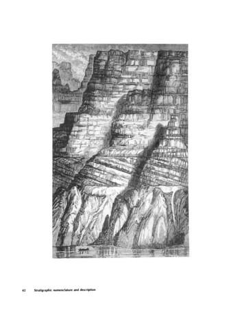
E6CONTRIBUTIONS TO STRATIGRAPHYposed in Tuna Canyon in the southwest part of the Topanga quadrangle, Los Angeles County (pi. 3A).Smaller, isolated exposures are present in Solstice, Trancas, andZuma Canyons. The base is not exposed in the mapped area, but eastof Santa Ynez Canyon it rests on the Santa Monica Slate or on a thinnonmarine conglomerate; the sequence is unconformably(?) overlainby the Coal Canyon Formation or the intervening Simi(?) Conglomerate (figs. 2, 3).LITHOLOGY, THICKNESS, AND STRATIGRAPHIC RELATIONSIn Tuna Canyon, the type locality, the formation is dominantlythick-bedded graded laminated beds of coarse-grained arkosicsandstone (turbidite) containing abundant fragments of blackslate(?). Some beds show convolute lamination, load casts, low-anglecross lamination, or concentrations of carbonized plant fragments ormica. Fossiliferous sandstone and siltstone are present locally asinterbeds or thick lenses; sandy cobble conglomerate near the mouthof Tuna Canyon contains abundant fragments of slate(?) and as muchas 50 percent well-rounded cobbles and boulders of gray or greenishgray porphyries and quartzites.In Las Flores Canyon, the Tuna Canyon Formation consists chieflyof massive coarse-grained poorly sorted tightly packed unfossiliferouslithic sandstone that is a distinctive grayish orange pink and closelyjointed and fractured. The uppermost part contains several beds ofolive-gray siltstone that locally contains Foraminifera; olive-gray tograyish-red mudstone is present locally near the upper contact.In Solstice, Zuma, and Trancas Canyons, the formation consists ofvery thick- to thick-bedded fine- to coarse-grained sandstone (probably turbidites) and interbedded siltstone and small-pebble conglomerate. In Zuma Canyon, it locally contains mollusks andForaminifera.The Tuna Canyon Formation is nowhere completely exposed in themapped area. The maximum exposed thickness, in the PenaCanyon-TUna Canyon area, is nearly 800 m. East of Santa Ynez Canyon, equivalent strata rest on Upper Cretaceous(?) nonmarine redconglomerate (Trabuco Formation of Durrell, 1954) and the UpperJurassic Santa Monica Slate. The formation is overlain disconformably(?) by me Simi(?) Conglomerate in Solstice Canyon and by a basalconglomerate of the Coal Canyon Formation (Paleocene) in upperTuna Canyon and in Las Flores Canyon.AGENumerous fossil mollusk collections from the Tuna Canyon Formation are assigned to the Campanian Stage of the Upper Cretaceous;
NOMENCLATURE, SANTA MONICA MOUNTAINS, CALIFORNIAE7Stokes Canyon Breccia MemberCoiTeio Volcanics 14 - 6 0 - 7San Nicholas Mbradcjl.e Peak. M.ernber. ! iVaqueros Fm. * *.- '*"!-.0 "-.:.V.-Llajas(?) FormationEXPLANATION14.6 0.7 -Radiometric age, in millions of years(table 1)'.'»ft *. " .*," V*nO ». . 'i«o*f -.-Coal Canyon FormationSimi(?) ConglomerateTuna Canyon Formation(Base not exposed within limits of areaindicated above; basement rocks inferredfrom exposures nearby to northeast)- Quartz diorite p [uSanta Monica Slate,*EarlyMioceneEarly Miocene,Oligocene, andlate EoceneMiddle EoceneEarly PaleoceneLateCretaceousCretaceous andLate JurassicFIGURE 3 Correlation diagram of units north of the Malibu Coast fault (except forthose restricted to the upper plate of the Malibu Bowl fault).the diagnostic Campanian species Metaplacenticeras pacificum(Smith) is common. Microfossil localities are less abundant, but twocollections of Foraminifera, one from siltstone on the east wall of LasFlores Canyon and one from the east fork of Trancas Canyon, areassigned to the early Maestrichtian or Campanian Stage.SIMI(?) CONGLOMERATEThe name Simi Conglomerate is questionably applied to a distinctive thin nonmarine conglomeratic unit mapped locally at the base ofthe Tertiary sequence. The conglomerate is questionably correlatedwith the type Simi Conglomerate of the Simi Hills (Nelson, 1925). Thebest exposures in the mapped area are on the east wall of upperSolstice Canyon north of the Malibu Bowl fault in the Point Dumequadrangle (pi. 3B), where the sequence is about 46 m thick; theconglomerate is traceable westward for about a mile from that locality.In Solstice Canyon the Simi(?) is characterized by an abundance ofpolished, very well rounded cobbles and boulders of quartzite, granitic, rhyolitic, and gneissic rocks in conglomeratic coarse-grainedsandstone that contains a 1-m-thick bed of brick-red pisolitic clayeysandstone.
E8CONTRIBUTIONS TO STRATIGRAPHYOn the basis of its stratigraphic relations and position, the Simi(?)is inferred to be Paleocene in age. In the mapped area, the Simi(?) isconformably overlain by fossiliferous marine strata of the PaleoceneCoal Canyon Formation; in the Simi Hills area, the type Simi isunconformable on Upper Cretaceous beds, and just north of the hills,it yielded a boulder of fossiliferous sandstone containing the diagnostic Upper Cretaceous species Thrritella chicoensis Gabb (Kew, 1924, p.15-16).COAL CANYON FORMATIONDEFINITIONThe Coal Canyon Formation is here used for part of a fossiliferousmarine sequence of sandstone, pebble conglomerate, and siltstonethat unconformably(?) overlies the Tuna Canyon Formation andunderlies marine strata questionably assigned to the Llajas Formation. The name is taken from exposures in Carbon (formerly Coal)Canyon, the type locality, in the southeast part of the Malibu Beachquadrangle (pi. 3C). Large exposures are present in the north-centraland southwest parts of the Topanga quadrangle and in Solstice Canyon, on the Trancas Canyon-Zuma Canyon ridge, and west of TrancasCanyon in the Point Dume quadrangle.LITHOLOGY, THICKNESS, AND STRATIGRAPHIC RELATIONSThe Coal Canyon Formation consists chiefly of sandstone and pebbly sandstone; in some areas, the Topanga Canyon area in particular,it contains cliff-forming pebble conglomerate and siltstone; east ofTopanga Canyon, the upper part of the formation contains severalsmall pods of algal limestone.The sandstone is chiefly very fine to medium grained, poorly to wellsorted, and consists of subrounded quartz and feldspar in a sparseclayey matrix, locally biotitic; it locally contains abundant mollusks;beds commonly are thick and locally have graded upper parts andsharp upper contacts. Siltstone and silty claystone are present locallyin the upper part of the formation; they are closely jointed, haveconchoidal fracture, and contain abundant biotite and local partingsof fine-grained silty biotitic sandstone and calcareous beds or concretions as thick as 15 cm and as long as 1 m.Limestone occurs as scattered lenses and pods in siltstone sequences east of Topanga Canyon. Beds are massive, as thick as 5 m,and contain calcareous algal ike structures, granular calcite, sparsemollusks, Foraminifera, and scattered grains of quartz.Pebble-cobble conglomerate forms resistant steep slopes in Carbonand Topanga Canyons. It typically occurs in beds as much as 7 mthick with scattered pebbles, boulders, slabs, and interbeds of
NOMENCLATURE, SANTA MONICA MOUNTAINS, CALIFORNIAE9mudstone and medium- to coarse-grained sandstone. The rock consists of subrounded to well-rounded pebbles of light-colored graniticand gneissic rocks, brown and gray quartzite, and distinctive brickred or lavender quartz-bearing porphyry.The basal conglomerate locally exposed in upper Tuna Canyon contains rounded large cobbles and boulders of light-colored granitic andgneissic rocks and well-rounded cobbles of quartzite but lacks the redand lavender porphyries of the pebble-cobble conglomerate. The matrix is poorly sorted angular arkosic sandstone that contains abundantlithic fragments.The only complete section of the Coal Canyon Formation in the maparea is in Solstice Canyon, east-central Point Dume quadrangle,where it is about 335 m thick. However, the minimum thicknesssummed from incomplete sections in the Carbon Canyon-TopangaCanyon area is as great as 450 m where the sequence mapped as CoalCanyon may locally include some strata equivalent to the basal partof the overlying Llajas(?) Formation.The Coal Canyon Formation overlies the nonmarine Simi(?) Conglomerate or equivalent strata inferred to represent the base of theTertiary sequence; in its only complete section in Solstice Canyon, theformation is disconformably(?) overlain by marine strata of Eoceneage.AGEWidely distributed locally abundant megainvertebrate assemblages from the Coal Canyon, including such diagnostic species asThrritella pachecoensis Stanton and Mesalia martinezensis (Gabb),are assigned to the Martinez Stage (Paleocene) of the Pacific Coastmegainvertebrate classification (Weaver and others, 1944).A few collections of mollusks from siltstone in the Tuna-TopangaCanyon area are questionably assigned to the Eocene; the siltstonemay be a lateral equivalent of the Llajas(?) Formation farther west.LLAJAS(?) FORMATIONThe name Llajas(?) Formation is introduced for an unnamed sequence of Eocene marine sandstone and siltstone beds in Solstice andSteep Hill Canyons (pi. 3B). The formation is about 425 m thick inSolstice Canyon, between the Coal Canyon Formation below and thenonmarine Sespe above. The name is taken from strata on the northwest side of the north branch of Las Llajas Canyon just north of SimiValley, eastern Ventura County (Schenck, 1931, p. 455).In Solstice Canyon, the sequence consists of very fine grainedsandstone, siltstone, pebble conglomerate, and interbedded platy toshaly siltstone and mudstone; it is locally characterized by fossil
E10CONTRIBUTIONS TO STRATIGRAPHYmolluscan species not found in other stratigraphic units. The sequence is accordant with the Coal Canyon Formation below and thenonmarine Sespe Formation above.Molluscan faunas from the Llajas(?), which include such diagnosticspecies as Ectinochilus supraplicatus (Gabb), Thrritella buwaldanaDickerson, and T. Uvasana Conrad, are assigned to the "Domengine"Stage of the Eocene.SESPE FORMATIONThe name Sespe Formation is retained for a widespread predominantly nonmarine redbed sequence of sandstone, pebbly sandstone,and mudstone. The name was extended from Sespe Creek north of theSanta Clara River. An essentially complete section of the Sespe isexposed only in the upper Solstice Canyon area, where about 1,000 mis present; both lower and upper boundaries are accordant. No fossilshave been found in the formation in the Santa Monica Mountains; itslate Eocene, Oligocene, and early Miocene age assignment is based onits stratigraphic position above marine middle Eocene strata andbelow marine lower Miocene strata.PIUMA MEMBERThe Piuma Member of the Sespe Formation is here named for exposures in Piuma Road and at the head of Carbon Canyon in the eastcentral Malibu Beach quadrangle (pi. 3D). In this area the lower andupper parts of the Vaqueros Formation tongue eastward into nonmarine strata (pi. 2 and fig. 3). The sequence here consists of a basalnonmarine sandstone about 60 m thick, a marine(?) sandstonemudstone sequence about 45 m thick, and an upper nonmarinesandstone-mudstone sequence about 282 m thick. Only the lower andupper units are considered tongues of the Piuma Member, the middleunit being considered a tongue of the Vaqueros Formation. The lowertongue of the Piuma Member lies conformably on the undivided Sespebelow. In contrast to the thicker bedded more coarsely grainedsandstone and conglomerate below, the Piuma is distinguished bythinner individual beds, sandstone of generally finer grain size, absence of pebble and cobble conglomerate, and more interbedded lacustrine or lagoonal siltstone.The lower tongue of the Piuma Member is grayish-red mediumgrained biotitic sandstone with sparse stringers of small pebbles andchips of red mudstone; some beds have a laminated appearance produced by concentrations of biotite and partings of brownish-gray topale-olive-gray mudstone. The medial unit, assigned to the VaquerosFormation, consists of medium- to coarse-grained poorly sortedfeldspathic sandstone that contains rare casts of Thrritella inezana,
NOMENCLATURE, SANTA MONICA MOUNTAINS, CALIFORNIAEllsome interbeds of olive-gray mudstone or shale with casts of reeds,and lenses of siltstone chips. The upper tongue of the Piuma Memberconsists of gray, grayish-red, and olive-gray sandstone, pebblysandstone, and mudstone, and a 0.5-m-thick bed of resistant nodularlimestone. The sandstone occurs in beds as thick as 2.5 m and ismedium- to coarse-grained, well sorted, and feldspathic, with subangular to subrounded grains, and contains abundant locally hematizedbiotite. Mudstone occurs as partings or layers up to 8 m thick.VAQUEROS FORMATIONThe name Vaqueros Formation is retained for the sequence that isabove the Sespe Formation and below the Topanga Group and thatcharacteristically contains the Thrritella inezana fauna. Although thename is from central California, it is well established in coastalsouthern California and is used consistently throughout interveningareas to refer to a well-recognized and widespread predominantlymarine sequence that contains a distinctive molluscan fauna.The Vaqueros is present throughout much of the mapped area westof Hina Canyon; however, the sandy nearshore marine facies tongueseastward into nonmarine strata (Piuma Member of the Sespe Formation) between Malibu and Las Flores Canyons such that the marinefacies in that area is contained within nonmarine beds above andbelow (pi. 2 and fig. 3). West of the Malibu Beach quadrangle, thesandy nearshore marine facies interfingers with dark platy or shalysiltstone. In the western part of the Point Dume quadrangle (pi. 3E)and farther west, the dark siltstone facies that predominates in thelower part of the Vaqueros (Danielson Member) is overlain by a thicktongue of sandstone (San Nicholas Member). Here the Vaqueros isoverlain by another dark siltstone, the Encinal Member of the Topanga Canyon Formation (see pi. 2 and fig. 3), and the topmost part ofthe San Nicholas may include some lateral equivalents of the lowermost sandstone of the Topanga Canyon Formation as known farthereast.The Vaqueros consists of medium- to coarse-grained well-sortedthin- to thick-bedded biotitic sandstone and interbedded greenish orreddish mudstone. Sandstone beds are flat laminated and locallygraded. In Malibu Canyon and west to Castro Peak, some of the pebbly sandstone beds and the red and green variegated mudstones interbedded in the predominantly nearshore marine sequence may represent brief episodes of nonmarine deposition. Farther west, in thewestern part of the Point Dume quadrangle and the Triunfo Passquadrangle, nonmarine beds seem to be absent, and the sequencegrades into deposits probably representing neritic environments. Anincomplete section of the Vaqueros in Malibu Canyon is about 400 m
E12CONTRIBUTIONS TO STRATIGRAPHYthick, whereas a complete section in the Solstice Canyon area is about800 m thick.DANIELSON MEMBERThe Danielson Member of the Vaqueros Formation consists of bedstermed the Danielson Formation by Sonneman (1956), who named theunit for exposures on the Danielson Ranch in Big Sycamore Canyon(fig. 1) in the Newbury Park 7.5-minute quadrangle a few milesnorthwest of San Nicholas Canyon (fig. 2), where he identified correlative strata. Although Sonneman's thesis (1956) is unpublished,the name Danielson Member is appropriate for the mudstone andsiltstone beds that characteristically contain the Thrritella inezanamolluscan fauna and that are well exposed in upper Trancas Canyon,the reference locality (pi. 3E).As exposed in San Nicholas Canyon, the Danielson Member is predominantly grayish black very fine grained sandy siltstone ormudstone, in medium and thin beds generally with indistinct parallellamination. Fractures are locally platy or shaly but more commonlyconchoidal or irregularly subparallel to bedding. Several prominentinterbeds, Vs to 1 m thick, of calcareous very fine grained sandstoneand sandy mudstone contain fossil remains ofThrritella inezana Conrad in such numbers as to locally form biostromes.It is conformably overlain by the San Nicholas Member of the Vaqueros Formation. The base is not exposed in the area where theDanielson has been mapped, but equivalent strata in the undividedVaqueros of the western part of the Point Dume quadrangle lie conformably on redbeds of the Sespe Formation.In addition to the numerous fossils of Thrritella inezana, which isdiagnostic of the "Vaqueros" Stage, the siltstone locally containshighly weathered Foraminifera and fish scales. Sonneman (1956, p.14, 15) reports that the black shale of the Danielson containsForaminifera referable to the Zemorrian Stage.SAN NICHOLAS MEMBERThe San Nicholas Member is here named for exposures in SanNicholas Canyon (fig. 2) in the eastern part of the Triunfo Pass quadrangle, where about 150 m of cliff-forming sandstone crops out. To thewest, this member has been mapped as the "Nicholas Formation" bySonneman (1956).The San Nicholas Member is predominantly very thick bedded tomassive cliff- and ledge-forming s
Sespe Formation, for a redbed sequence in the Sespe Creek area north of the Santa Clara River, Ventura County. Named by Watts (1897). Kew (1923,1924) introduced the following names in the eastern Ventura County-northern Santa Monica Mountains area: Modelo Formation