Transcription
Space-based Doppler Winds LIDAR: A Vital National NeedSubmitted by:Paul Hays, Michael Dehring, Len Fisk, Pete TchorykMichigan Aerospace CorporationAnn Arbor, MI 48108Phone: (734) 975-8777, Email: mdehring@michiganaerospace.comIvan Dors, James RyanUniversity of New HampshireDurham, NH 03824Phone: (603) 862-2867, Email: ivan.dors@unh.eduJinxue WangRaytheon Space and Airborne SystemsSanta Barbara Remote SensingGoleta, CA 93117Phone: (805) 562-7137, Email: jwang@raytheon.comMichael HardestyNOAAEnvironmental Technology Laboratory325 Broadway R/ETLBoulder, Colorado 80305Phone: (303) 497-6568, Email: michael.hardesty@noaa.govBruce GentryNASA Goddard Space Flight CenterCode 912Greenbelt, MD 20771Phone: (301) 614-6271, Email: gentry@agnes.gsfc.nasa.govFloyd HovisFibertek, Inc510 Herndon ParkwayHerndon, Virginia 20170Phone: (703) 471-7671, Email: fhovis@fibertek.comMay 2005In response to National Research Council (NRC) Decadal StudyRequest For Information (RFI)1
1 Table of Contents1TABLE OF CONTENTS.22EXECUTIVE SUMMARY.23APPLICATIONS & NEED FOR GLOBAL WINDS .34TECHNOLOGY OVERVIEW AND READINESS ASSESSMENT.64.14.1.14.1.24.24.34.44.55OVERVIEW OF DOPPLER WIND LIDAR TECHNOLOGY .6Coherent & Direct-detection Doppler Wind Lidar.7Direct-Detection Doppler Wind Lidar.8LASER TRANSMITTER TECHNOLOGY AND READINESS .10TELESCOPE TECHNOLOGY AND READINESS .12RECEIVER TECHNOLOGY AND READINESS .13TECHNOLOGY READINESS SUMMARY .13MISSION COST SUMMARY .145.15.25.35.45.55.65.7LASER TRANSMITTER COST .14SCANNING TELESCOPE/ BEAM DELIVERY SUBSYSTEM COST .14RECEIVER/DETECTOR SUBSYSTEM COST .15INSTRUMENT DESIGN, FABRICATION, AND ASSEMBLY .15INTEGRATION AND TEST.15SPACECRAFT, LAUNCH AND SUPPORT .15MISSION OPERATIONS & MANAGEMENT RESERVE .152 Executive SummaryIn response to the National Research Council (NRC) Decadal Study Request for Information(RFI), we would like to propose a space-based Doppler winds LIght Detection And Ranging(LIDAR) demonstration mission with a targeted launch date of 2011-2012. The mission willaddress our vital national needs for high-resolution global tropospheric wind observation, whichwill lead to improved long-range weather forecasting, more accurate hurricane landfallprediction, improved climate models, better battlefield environmental predictions for militaryoperations, more accurate upper-tropospheric/lower-stratospheric winds for Air Force operations,and potential chemical-biological release trajectory prediction for homeland security operations.The launch of a space-based winds LIDAR demonstration mission in the 2011-2012 time frameis critical to enable operational winds LIDAR on the National Polar Orbiting EnvironmentalSatellite Systems (NPOESS) in the 2015-2016 time frame. Global tropospheric wind profiles arethe #1 unmet Environmental Data Record (EDR) of NPOESS. This is especially urgent since theUS, as a world leader in space technology and Earth observation, is falling behind Europe andJapan in space-based winds LIDAR development and deployment. As a result of stronggovernment and private industry investment in the last 5-10 years, all key technologies for spacebased direct-detection Doppler winds LIDAR have reached Technology Readiness Levels (TRL)of 5-7. The cost of such a mission, estimated at about 200M, is clearly well justified based onits very strong national needs and significant societal benefits. There is a strong consensus in theoperational agencies and user communities that space-based winds LIDAR mission should beconsidered as a top priority for future space missions. Mission planning and phase A/B studymust commence immediately to enable a launch in 2011-2012.2
3 Applications & Need for Global WindsThroughout history, various wind measurement techniques have been employed, ranging fromhuman observation to sophisticated wind LIDARs. Wind vanes were used by the ancientEgyptians and Chinese to measure the direction of air flow. The Greeks measured winds byobserving the directions and deformation of trees and grass fields. Aristotle wrote aboutrelationships between cloud formation and winds. Despite this long history of interest, there isstill no direct measurement of global wind profiles throughout the troposphere and lowerstratosphere (approximately 0 to 30 km). Today such measurements are critical for improvinglong-range weather forecasting, hurricane tracking, troposphere-stratosphere exchange studies,global pollution tracing, and climate studies. The World Meteorological Organization (WMO)has consistently ranked direct observation of global winds profiles from satellites as one of themost challenging and important observations.The current knowledge of atmospheric dynamics and processes can be gauged by theeffectiveness of modern Numerical Weather Prediction (NWP). NWP relies on input data tocharacterize the initial state of the atmosphere, and computational models to predict itsspatiotemporal evolution. Advancements in atmospheric models and computing power over theyears have far out-gained the improvement in atmospheric observations. Thus, the mostproductive step toward an improved understanding of atmospheric processes, weather, andclimate change involves new atmospheric measurements that can fill the gaps of our data.Accurate modeling of atmospheric dynamics requires 4-dimensional input data (volumetricdata over time) for the balancing of energy, mass, and momentum. These measurementsinclude temperature, radiance, albedo, composition, humidity, pressure, and wind velocity, allof which are measured from ground, ocean, balloon, and satellite platforms. Modern windmeasurements are limited and do not provide the volumetric density nor the sampling to reachthe full potential of NWP. The National Oceanic and Atmospheric Administration (NOAA) andWMO recognizes that global tropospheric wind data are the single most important inputmeasurement required to improve NWP.The current wind measurements include ground stations, buoys, ships, radiosondes,aircraft, ground-based wind profilers, and radiometer, scatterometer, and cloud tracking satellites.Table 1 summarizes these measurements. The ground stations (ASOS, Weather Bug), buoysnetworks (MON, TAO), ships (VOS), and scatterometers (NSCAT, SeaWinds) provide goodcoverage; however offer little atmospheric profile information. Ground-based wind profilers(NEXRAD) offer superior wind measurements when aerosols or clouds are present. Cloudtracking satellites (Meteosat) provide wind measurements at locations and altitudes where cloudsor aerosols exist but with poor altitude resolution. Water vapor channels on space-basedradiometers (SMMR, TOV) provide wind velocity as a secondary data product, but again withpoor accuracy and resolution. Radiosondes (RaObs) and aircraft (ACARS) measurementsprovide good wind profiles, but are primarily performed over well-populated regions in thenorthern hemisphere. Few wind measurements are performed in the clear-air over the oceans andsouthern hemisphere. Figure 1 illustrates the sparseness of these measurements, and thecapability of a global tropospheric wind LIDAR to fill the measurement voids. The high value oftropospheric wind for improved weather prediction and climate studies is highlighted by the factthat it is ranked as the highest priority unmet measurement by NPOESS/IPO, a joint officerepresenting DOD, NOAA, and NASA.3
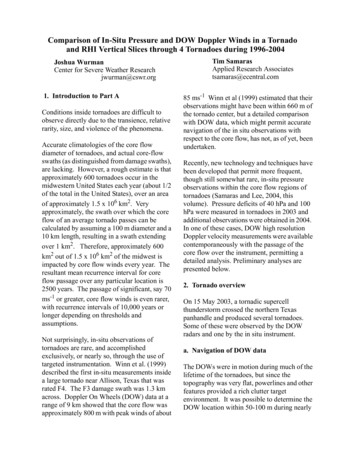
Table 1. Summary of wind measurements currently used for NWP.Instrument TypeGround stationsBuoysShipsRadiosondesAircraftWind evel0:30 km0-20 kmAerosol level0-30 kmWind Accuracy 1 m/s1 m/s1 m/s 1 m/s2-5 m/s1 m/s 2 m/sCoverageLandOceanOceanMostly NH LandMostly NH LandLandLand & OceanSea-levelCloud-top level2 m/s 3 m/sOceanLand & ity/cloudsNot independentClear skiesCloudy skiesFigure 1: Points in blue are the existing locations of Radiosonde stations. The green points represent theglobal sampling that can be achieved with a space borne Doppler wind LIDAR.Doppler Wind LIDAR (DWL) is a general term for an active remote sensing instrumentthat uses aerosol and/or molecular backscatter to measure wind. Specifically, the atmosphericbackscatter from a laser pulse is collected by a telescope, range-gated, and spectrally analyzed todetermine the Doppler shift. The range gates, Doppler shift, telescope look-angle and satelliteorbit can be used to calculate the wind velocity in the ground frame as a function of altitude.Global tropospheric winds can be measured from a satellite using this method. DWL instrumentconcepts can be divided into two main categories: Direct detection and coherent detection.These techniques are viable only if they are able to collect sufficient backscatter from regionswith low aerosol content and produce a useful velocity measurement that helps fill the data voidover the oceans and southern hemisphere.A space-borne DWL instrument is seen as an enabling technology that would provideglobal tropospheric wind measurements, improved NWP, and subsequent socio-economicbenefits. Numeric simulations have been performed to determine the impact of different DWLperformance specifications on NWP. One such simulation technique used by NOAA and NASAscientists is called the Observing System Simulation Experiments (OSSEs). OSSEs haverepeatedly shown that the greatest impact to weather forecasting will come from fulltropospheric soundings, clouds permitting, with a scanning telescope. Simulations performed by4
the European Center for Medium range Weather Forecasting (ECMWF) use a differentsimulation technique, yet produce similar findings.The Global Tropospheric Wind Sounder (GTWS) Science Definition Team (SDT) is ajoint NASA-NOAA effort formed to generate a set of data requirements for space-borne DWLinstruments. The data requirements are intended to guide the design of future instruments inorder to ensure a positive impact on science and operational weather forecasting. Theserequirements are based on the abilities of current wind profilers and the results of OSSEs. Table2 shows the threshold and objective requirements for a space-borne Doppler wind LIDARinstrument defined by the GTWS SDT. The threshold requirements represent the minimum datarequirements, whereas the objective requirements define the desired data product for the greatestimpact. The requirements in Table 2 were formulated with consideration of the technologicalissues associated with the state-of-the-art of LIDAR technologies and the logistical issues withtwice-a-day global coverage performed by a single space-borne instrument. Table 2 shows thecorresponding set of specifications devised by ECMWF to be nearly identical.Table 2. GTWS and ECMWF data product requirements for a space-borne Doppler Windfor Target Sample Volume.GTWS ThresholdGTWS ObjectiveDepth of Regard (DOR)[km]0-200-30Vertical TSV resolution [km]DOR top to tropopauseNot required2.0Tropopause to boundary layer top1.00.5Boundary layer top to ground-level0.50.25Horizontal TSV dimension [km]10025(maximum averaging)Horizontal location accuracy [km]0.50.5Horizontal resolution [km]350100(distance between TSVs)22Number of LOS perspectives in TSVAccuracy (1- ) of LOSH [m/s]3.0 (1.2)2.0 (1.4)Above boundary layer3.0 (1.2)1.0 (1.0)Within boundary layer(# in () is s within TSV)Horizontal component bias [m/s]0.10.05Maximum horizontal speed [m/s]Above boundary layer75100Within boundary layer5050Temporal resolution [hours] (revisit126period)Data product latency [hours]2.752.75LIDAR. TSV is an acronymECMWF Objective0-202.01.00.550N/A200132N/AN/AN/A123The societal, economic and scientific impact of a space-borne DWL that meets theGTWS SDT data specifications is wide-spread 1,2,3. Vastly improved weather forecasts will bethe primary societal impact, including the improvement of regional meteorological forecasts(temperature, visibility, sky conditions, pressure, humidity, and wind), air quality forecasts, andsevere weather forecasts. The improved weather and air quality forecast will improve decisionsin commerce, health, and other weather-dependent fields. More accurate forecasting of severeweathers, such as improved hurricane tracking, will save lives and properties through more1M. Masutani, J.C. Woollen, S.L. Lord, J.C. Derber, G.D. Emmitt, S.A. Wood, S. Greco, J. Terry, R. Atlas, and T.J. Kleespies,“Impact Assessment of a Doppler Wind Lidar for NPOESS/OSSE”, AMS Sixth Symposium on Integrated Observing Systems,Orlando, Florida, January 2002.2W.E. Baker, G.D. Emmitt, F. Robertson, R.M. Atlas, J.E. Molinari, D.A. Bowdle, J. Paegle, R.M. Hardesty, R.T. Menzies, T.N.Krishnamurti, R.A. Brown, M.J. Post, J.R. Anderson, A.C. Lorenc and J. McElroy, “Lidar-measured winds from space: A keycomponent for weather and climate prediction”, Bull. Amer. Meteor. Soc., 76, 869-888, 1995.3J. J. Cordes, “Economic Benefits and Costs of Developing and Deploying a Space-Based Wind LIDAR”, Final Report for NWS,NOAA, and US DoC, March 1995.5
efficient evacuations. The American public is increasingly demanding this capability asdemonstrated in the 2004 hurricane Charley. For example, several articles have been publishedin USA Today on the inaccuracy of hurricane Charley’s landfall and track prediction that led toloss of lives and properties in areas that were not forecasted to be in hurricane Charley’s track,and therefore, were not properly evacuatedThe economic benefits provided by a space-borne DWL include more intelligent andefficient environmental policies, reduced over-warning of severe weather events, and reducedairline fuel consumption from improved forecasts and planning. Such benefits are estimated tosave about 200M per year in 1994 U.S. dollars3. The required accuracy, resolution, andcoverage required to realize these benefits are not possible with the current passive remotesensing technology, nor feasible with the current profiler and sounding systems. The economicimpact of global tropospheric winds on the U.S. will pay for the space-borne DWL mission inthe first year.The scientific impact is the advanced understanding of the Earth’s atmosphere from theunprecedented measurement. Consistent and long-term observations of global troposphericwinds profiles can be used to monitor seasonal variations and eventually climate variability andchanges. Of particular interest are the bulk kinetic energy in the atmosphere and its correlationwith thermal energy (global warming) trends and changes in circulation patterns caused byglobal warming-induced melting of the polar ice caps and ice sheets. The continual monitoringand measurement of the Earth’s velocity field will be a key component to future long-termmonitoring and climate prediction models. The secondary data products that result from someDWL techniques, although less accurate than other measurement methods, may be found useful.These products include aerosol backscattering coefficient profiles, extinction profiles, andtemperature, all of which are important to climate forcing and global warming studies.4 Technology Overview and Readiness Assessment4.1 Overview of Doppler Wind Lidar TechnologyLIDAR systems generally consist of three major optical subsystems, which are the lasertransmitter subsystem, the telescope subsystem, and a detection/receiver subsystem. The lasertransmitter subsystem has been the technology “tall pole” that has prevented broader deploymentand utilization of space-borne LIDARs for both civilian and military applications despite thehigh scientific potential and strong need However, the significant technology advancementsmade possible by substantial government and industry investments, which are discussed below,are rapidly changing this assessment and are making operational space-borne LIDAR systemsmore feasible. A scanning telescope is necessary to measure line-of-sight wind speed frommultiple look angles to determine the wind speed and direction in a target volume. Requirementsanalysis and performance trade studies conducted over the past decade have indicated that these“looks” need to be from a step-and-stare configuration as opposed to a continuous scanningconfiguration. The implication of this requirement is that a telescope must be accelerated anddecelerated at a relatively rapid rate to point to the same target volume from a forward and aftdirection, which poses a challenge for platform stabilization. The detection/ receiver subsystemis considered to be the most technologically advanced subsystem of the wind LIDAR instrument.There are a variety of proven techniques with different capabilities, which are discribed below.6
In this section, we will first discuss the basic concept of Doppler winds LIDAR. Then wewill present a detailed assessment of the technology readiness level (TRL) of the three keysubsystems of the proposed direct-detection Doppler winds LIDAR, namely the laser transmittersubsystem, the scanning telescope subsystem, and the receiver subsystem. Our assessmentindicate that all key subsystems are at TRL 5-6 or higher and should allow the beginning ofspace-borne Doppler winds Phase A/B program with acceptable technical, schedule and costrisks that are comparable to many previous and current passive and active space sensors.4.1.1Coherent & Direct-detection Doppler Wind LidarTwo different methods for measuring the Doppler shift of backscattered laser light haveemerged as potential methods for making global wind observations from space. The directdetection method, which uses high-resolution optical devices such as a Fabry-Perot etalons,detects the Doppler shift directly from spectrum of light backscattered from atmospheric airmolecules and aerosols. The other approach is optical heterodyning, or coherent detection, whichmeasures Doppler shifts by beating the backscattered laser light with a laser source from a stablelocal oscillator. Coherent techniques use the same basic principles as Doppler radar, and rely onbackscattering from atmospheric aerosols. Using coherent detection can provide very accuratewinds measurements in atmospheric regions with adequate amount of aerosol particles such asthe boundary layer. This is in contrast to direct detection, which is able to measure winds frommolecular backscatter independent of the aerosol field. The ability of direct detection to measurewinds in clean air makes it an attractive operational space-borne Doppler winds LIDARtechnique to cover the whole troposphere and lower stratosphere (0 – 20 to 30 km), which isrequired by the data user communities. Both direct detection and coherent detection have theiradvantages and disadvantages depending on the types of applications and measurementrequirements. They can complement each other in that the coherent detection can target theboundary layer (i.e. 0 – 3 km) and direct-detection targets the middle and upper troposphere (3 –20 to 30 km). This hybrid approach to space-borne wind LIDAR has been suggested by Emmitt4.However, the focus of this white paper is to detail the direct-detection Doppler wind LIDARtechnology and readiness assessment. The discussion is relevant for the direct-detection systemto be implemented as a stand-alone instrument or part of a hybrid system.The complementarily that exists between coherent and direct-detection techniques hasprecipitated hybrid concepts to be formed to meld the different sensing technologies for asatellite observing system. This “best of both worlds” approach, it is believed, has advantages inthat the size, weight, power requirements of an individual system exceed that of the combinedsystem to meet the same performance over all measurable and desired conditions. However, todate, a hybrid instrument has never been demonstrated even though several instruments of eachtype have been demonstrated individually. The heritage of coherent wind LIDARs extend backto the 1960s and have included ground based and aircraft systems. NASA and NOAA, andseveral industry technology leaders, develop and utilize coherent wind LIDAR for scientific andtechnology field studies. Examples of modern direct-detection systems include the NASAGoddard GLOW instrument and the instruments developed through the NOAA GroundWindsprogram. Another important direct-detection wind LIDAR instrument is the Atmospheric LaserDoppler Instrument (ALADIN) developed by the European Space Agency (ESA), which will belaunched on the ADM-Aeolus satellite in October 2007.4Emmitt, G.D: Hybrid technology Doppler wind LIDAR: assessment of simulated data products for a space-based systemconcept., SPIE Lidar Remote Sensing for Industry and Environment Monitoring, Sendai, Japan. October 2000.7
4.1.2 Direct-Detection Doppler Wind LidarThe two most common direct-detection techniques for measuring the Doppler shift fromatmospheric backscatter are the double-edge5 and the fringe-imaging6 method. Several doubleedge and fringe-imaging systems have demonstrated the efficiency of each technique inmeasuring the Doppler shift from atmospheric molecular and aerosol backscatter. The mostnotable systems are the double-edge GLOW instrument developed by NASA Goddard7, and theGroundWinds 8 multi-order, photon-recycled fringe imaging systems in New Hampshire(GWNH), Hawaii (GWHI)9 and the BalloonWinds instrument, which are funded by NOAA andare being developed by the University of New Hampshire (UNH), Michigan AerospaceCorporation (MAC), Raytheon, and Fibertek. Common to most direct-detection instruments thathave been proposed and developed for global wind sounding is the use of tunable Fabry-Perotetalons to resolve the wavelength of the backscatter. Many system implementations, includingGLOW and GroundWinds, often employ two Fabry-Perot interferometer channels combined intoa single receiver that are independently optimized to sense the Doppler shift from aerosols andmolecules. A notable exception is the aerosol channel of the ADM-Aeolus Atmospheric LaserDoppler Instrument (ALADIN), which uses a Fizeau interferometer but employs a Fabry-Perotfor the molecular channel. While the molecular channel of these instruments retain sensitivity toaerosols, the aerosol channel provides superior accuracies when aerosols are present. The dualchannel configuration would be advantageous for a satellite wind system if a direct-detectionsystem were the only instrument. An aerosol channel would provide more detail on scatteringfrom clouds as well as provide an accurate ground echo, which is useful for calibration since theground provides a true Doppler zero reference. In a hybrid (coherent & direct) system, the use ofthe aerosol channel would not be necessary because the coherent wind sensor would provide theneeded measurements from aerosols.The laser wavelength that would be employed for a space-borne wind LIDAR is 355 nm,or the 3rd harmonic of Nd:YAG lasers. This offers the optimal signal return for sensing the windfield from clear air because the molecular backscatter is proportional to 1/ 4 but shorterwavelengths (such as 266 nm) suffer to much attenuation by the atmosphere. The molecularchannel of the GLOW system, and the molecular and aerosol channel of the GWHI systemoperate at 355 nm. An important advantage of using 355 nm for direct detection is that theNd:YAG laser technology for generating this wavelength is currently the most mature lasertransmitter technology for space applications.While the aforementioned direct-detection systems employ Fabry-Perot etalons as thewavelength resolving element, they can be used in a variety of implementations. Described inFigure 2 are the main differences between the double-edge method and the fringe imagingmethod. The double-edge method measures the Doppler shift from the relative intensities in twospectral edge filters positioned symmetrically about the central laser frequency (or Zero Wind),Figure 2. The signals collected from the spectral edges are captured by single element detectorssuch as Photo-Multiplier Tubes (PMTs) or Avalanche Photo-Diodes (APDs). Range gating the5C.L. Korb, B. M. Gentry, and C. Y. Weng, “Edge technique, theory and application to the LIDAR measurement of atmosphericwind,” Appl. Opt., 31, 4202-4213 (1992).6J.A. McKay, “Modeling of direct detection Doppler wind LIDAR: II. The fringe imaging technique,” App. Optics, 37, 64876493, 19997B.M Gentry, H. Chen, and S. Li. “Wind Measurements with a Molecular Doppler Lidar”. Optics Letters, 25, 1231-1233. 20008P. B. Hays and C. A. Nardell. “GroundWinds: A Direct Detection Doppler LIDAR Technology Demonstration”, Invited Paper, ,SPIE 2nd Asia-Pacific Remote Sensing Conference, Sendai, Japan, October 20009“Performance and comparison of 532nm and 355nm groundwinds LIDARs”, M. T. Dehring, C. A. Nardell, J. C. Pavlich, P. B.Hays, I. G. Dors. SPIE Remote Sensing conference, Hangzhou, China, October 20028
backscattered signal collected with these devices from a satellite could be accomplished withphoton counters. Due to the low spectral sampling inherent to double-edge systems wind speedhas to be determined by applying line-shape models that can accurately represent the temperatureand Doppler response, which requires that the atmospheric temperature and aerosol contributionto the signal be explicitly known prior to analysis. Despite the low spectral sampling of thedouble-edge technique, the use of single element detectors confers simplicity and low cost.Figure 2: The plot above depicts the representative composite Doppler-shifted and unshifted lineshapespectrum from aerosols and molecules (Rayleigh). Also, depicted in the figure are edge filters to indicate theway a double-edge instrument samples the spectrum; fringe imaging instruments resolve the full spectrum into many channels, number of channels ranges from 10 to over 100.Fringe imaging instruments 10 , such as GroundWinds 11 , resolve the backscatteredspectrum from aerosols and molecules into multiple spectral channels and can thus use multipleorders of interference from the Fabry-Perot etalons (see Figure 3). The enabling technologiescentral to the GroundWinds fringe imaging direct-detection Doppler wind LIDARs are photonrecycling (U.S. patent #6,163,380), the Circle to LIne Optic (CLIO- U.S. Patent #4,893,003) anduse of highly efficient Charge Coupled Devices (CCDs). Photon recycling is a technology thatenhances the overall throughput and net efficiency of a Fabry-Perot Etalon (FPE) by up to afactor of 5. In Figure 3 the right most 4 orders of interference are contributed by photonrecycling. The gain in signal by implementing photon recycling has a high potential for loweringthe requirements on laser power and telescope aperture size for a satellite observing system. Theenhanced spectral resolution of the fringe imaging technique enables the measurement of windspeed as well as other optical properties such as aerosol contribution to the total collectedbackscatter and temperature. The random thermal motion of molecules, which is proportional totemperature, determines the width of the backscattered spectrum and can be directly measured10M.J. McGill and J.D. Sphinhirne, “A Comparison of two direct-detection Doppler LIDAR techniques”, Opt. Eng 37, 26752687, 199811J. Wang, M. Dehring, C. A. Nardell, P. B. Hays, D. Dykeman,, & B. Moore III. “Direct Detection Doppler Winds Lidar:Ground-based Operation to Space”, SPIE Optical Science and Technology. San Diego, CA August 2003.9
with a fringe imaging system. Multi-order fringe imaging LIDARs, such as GroundWinds,achieve much higher spectral resolution than the double-edge based techniques however theyrequire more complicated detectors (such as CCDs). As will be demonstrated in theBalloonWinds12 instrument, a single CCD can be used for both of its optimized channels, whichhas several system benefits such as a reduction is size, weight, power, and data bandwidth thanimplementing separate detectors for each channel.Figure 3: Plot on the left is a fringe image taken with the molecular channel of the GroundWinds HIinterferometer. The two plots on the right are the spectrum from the laser, bottom right, and backscatteredspectrum from an altitude of 5
Data product latency [hours] 2.75 2.75 3 The societal, economic and scientific impact of a space-borne DWL that meets the GTWS SDT data specifications is wide-spread 1,2,3. Vastly improved weather forecasts will be the primary societal impact, including the improvement of regional meteorological forecasts 1