Transcription
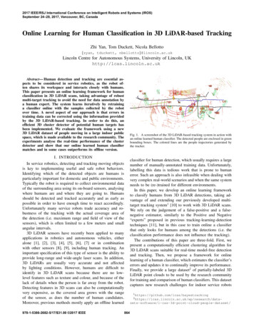
2017 IEEE/RSJ International Conference on Intelligent Robots and Systems (IROS)September 24–28, 2017, Vancouver, BC, CanadaOnline Learning for Human Classification in 3D LiDAR-based TrackingZhi Yan, Tom Duckett, Nicola Bellotto{zyan, tduckett, nbellotto}@lincoln.ac.ukLincoln Centre for Autonomous Systems, University of Lincoln, UKhttp://lcas.lincoln.ac.ukAbstract— Human detection and tracking are essential aspects to be considered in service robotics, as the robot often shares its workspace and interacts closely with humans.This paper presents an online learning framework for humanclassification in 3D LiDAR scans, taking advantage of robustmulti-target tracking to avoid the need for data annotation bya human expert. The system learns iteratively by retraininga classifier online with the samples collected by the robotover time. A novel aspect of our approach is that errors intraining data can be corrected using the information providedby the 3D LiDAR-based tracking. In order to do this, anefficient 3D cluster detector of potential human targets hasbeen implemented. We evaluate the framework using a new3D LiDAR dataset of people moving in a large indoor publicspace, which is made available to the research community. Theexperiments analyse the real-time performance of the clusterdetector and show that our online learned human classifiermatches and in some cases outperforms its offline version.Fig. 1. A screenshot of the 3D LiDAR-based tracking system in action withan online learned human classifier. The detected people are enclosed in greenbounding boxes. The colored lines are the people trajectories generated bythe tracker.I. INTRODUCTIONclassifier for human detection, which usually requires a largenumber of manually-annotated training data. Unfortunately,labelling this data is tedious work that is prone to humanerror. Such an approach is also infeasible when dealing withvery complex real-world scenarios and when the same systemneeds to be (re-)trained for different environments.In this paper, we develop an online learning frameworkto classify humans from 3D LiDAR detections, taking advantage of and extending our previously developed multitarget tracking system1 [10] to work with 3D LiDAR scans.We rely on the judgement of a false-positive and a falsenegative estimator, similarly to the Positive and Negative“experts” proposed in previous tracking-learning-detectiontechniques [11], but in this case to train online a classifierthat only looks for humans among the detections (i.e. theclassification performance does not influence the tracking).The contributions of this paper are three-fold. First, wepresent a computationally efficient clustering algorithm for3D LiDAR scans suitable for real-time model-free detectionand tracking. Then, we propose a framework for onlinelearning of a human classifier, which estimates the classifier’serrors and updates it to continually improve its performance.Finally, we provide a large dataset2 of partially-labeled 3DLiDAR point clouds to be used by the research communityfor training and comparison of human classifiers. This datasetcaptures new research challenges for indoor service robotsIn service robotics, detecting and tracking moving objectsis key to implementing useful and safe robot behaviors.Identifying which of the detected objects are humans isparticularly important for domestic and public environments.Typically the robot is required to collect environmental dataof the surrounding area using its on-board sensors, analysingwhere humans are and where they are going to. Humansshould be detected and tracked accurately and as early aspossible in order to have enough time to react accordingly.Unfortunately many service robots trade accuracy and robustness of the tracking with the actual coverage area ofthe detection (i.e. maximum range and field of view of thesensors), which is often limited to a few meters and smallangular intervals.3D LiDAR sensors have recently been applied to manyapplications in robotics and autonomous vehicles, eitheralone [1], [2], [3], [4], [5], [6], [7] or in combinationwith other sensors [8], [9], including human tracking. Animportant specification of this type of sensor is the ability toprovide long-range and wide-angle laser scans. In addition,3D LiDARs are usually very accurate and not affectedby lighting conditions. However, humans are difficult toidentify in 3D LiDAR scans because there are no lowlevel features such as texture and colour, and because of thelack of details when the person is far away from the robot.Detecting features in 3D scans can also be computationallyvery expensive, as the covered area grows with the rangeof the sensor, as does the number of human candidates.Moreover, previous methods mostly apply an offline learned978-1-5386-2682-5/17/ 31.00 2017 IEEE1 https://github.com/lcas/bayestracking2 ftware/l-cas-3d-point-cloud-people-dataset/864
including human groups, children, people with trolley, etc.The remainder of this paper is organized as follows.Section II gives an overview of the related literature, in particular about 3D LiDAR-based human detection and tracking.Then, we introduce our framework in Section III and thelink between tracking and online learning. The former ispresented in Section IV, including a detailed descriptionof the 3D cluster detection. The actual online learning isexplained in Section V, which clarifies the role of the P-Nexperts in the classification improved by tracking. Section VIpresents the experimental setup and results, as well as ournew 3D LiDAR dataset. Finally, conclusions and futureresearch are discussed in Section VII.and assist human detection in the next LiDAR scan. Teichman et al. [5] presented a semi-supervised learning methodfor track classification. Their method requires a large setof labeled background objects (i.e. no pedestrians) to trainsclassifiers offline, which showed good performances for trackclassification but not for object recognition. Our solution,instead, simultaneously learns human and background, anditeratively corrects classification errors online.Besides datasets collected with RGB-D cameras [12], [13],[16], there are a few 3D LiDAR datasets available to thescientific community for outdoor scenarios [4], [6], [9], [17],but not with annotated data for human tracking in largeindoor environments, like the one presented here.Some authors proposed annotation-free methods. Deuge etal. [6] introduced an unsupervised feature learning approachfor outdoor object classification by projecting 3D LiDARscans into 2D depth images. Dewan et al. [18] proposeda model-free approach for detecting and tracking dynamicobjects, which relies only on motion cues. These methods,however, are either not very accurate or unsuitable for slowand static pedestrians.It is clear that there remains a large gap between the stateof the art and what would be required for an annotationfree, high-reliability human classification implementationthat works with 3D LiDAR scans. Our work helps toclose this gap by demonstrating that human classificationperformance can be improved by combining tracking andonline learning with a mobile robot in highly dynamicenvironments.II. RELATED WORKHuman detection and tracking have been widely studied inrecent years. Many popular approaches are based on RGB-Dcameras [12], [13], although these have limited range andfield of view. 3D LiDARs can be an alternative, but one of themain challenges working with these sensors is the difficultyof recognizing humans using only the relatively low information they provide. A possible approach to detect humansis by clustering point clouds in depth images or 3D laserscans. For example, Rusu [14] presented a straightforwardbut computationally expensive method based on Euclideandistance. Bogoslavskyi and Stachniss [15] proposed a fasterapproach, although the computational efficiency limits theclustering precision. In our method, instead, both runtimeand precision are opportunely balanced.A very common approach is to use an offline trained classifier for human detection. For example, Navarro-Serment etal. [1], introduced seven features for human classification andtrained an SVM classifier based on these features. Kidonoet al. [3] proposed two additional features considering the3D human shape and the clothing material (i.e. using thereflected laser beam intensities), showing significant classification improvements. Li et al. [7] implemented insteada resampling algorithm in order to improve the qualityof the geometric features proposed by the former authors.Spinello et al. [4] combined a top-down classifier based onvolumetric features and a bottom-up detector, to reduce falsepositives for distant persons tracked in 3D LiDAR scans.Wang and Posner [8] applied a sliding window approachto 3D point data for object detection, including humans.They divided the space enclosed by a 3D bounding boxinto sparse feature grids, then trained a linear SVM classifierbased on six features related to the occupancy of the cells,the distribution of points within them, and the reflectance ofthese points. The problem with offline methods, though, isthat the classifier needs to be manually retrained every timefor new environments.The above solutions rely on pre-trained classifiers to detecthumans from the most recent LiDAR scan. Only a few methods have been proposed that use tracking to boost humandetection. Shackleton et al. [2], for example, employed anExtended Kalman Filter to estimate the position of a targetIII. GENERAL FRAMEWORKOur learning framework is based on four main components: a 3D LiDAR point cluster detector, a multi-targettracker, a human classifier and a sample generator (seeFig. 2). At each iteration, a 3D LiDAR scan (i.e. 3D pointcloud) is first segmented into clusters. The position andvelocity of these clusters are estimated in real-time by amulti-target tracking system, which outputs the trajectoriesof all the clusters. At the same time, a classifier identifiesthe type of cluster, i.e. human or non-human. At first, theclassifier has to be initialised by supervised training withlabeled clusters of human subjects. The initial training set canbe very small though (e.g. one sample), as more samples willbe incrementally added and used for retraining the classifierin future iterations.The classifier can make two types of errors: false positiveand false negative. Based on the estimation of the error typeby two independent “experts”, i.e. a positive P-expert anda negative one N-expert, which cross-check the output ofthe classifier with that of the tracker, the sample generatorproduces new training data for the next iteration. In particular, the P-expert converts false negatives into positivesamples, while the N-expert converts false positives intonegative samples. When there are enough new samples, theclassifier is re-trained. The process typically iterates untilconvergence (i.e. no more false positives and false negatives)or some other stopping criterion is reached.865
Fig. 3. Examples of a human (1.68 m high) detected by a 3D LiDAR atdifferent distances.Fig. 2.obtaining a subset P P . This is necessary in orderto remove from object clusters points that belong to thefloor, accepting the fact that small parts of the object bottomcould be removed as well. Note that this simple but efficientsolution works well only for relatively flat ground, which isone of the assumptions in our scenarios.Point clusters are then extracted from the point cloud P ,based on the Euclidean distance between points in 3D space.A cluster can be defined as follows:Process details of the online learning framework.Our system, however, differs from the previous work [11]in three key aspects, namely the frequency of the trainingprocess, the independence of the tracker from the classifier,and the implementation of the experts. In particular, ratherthan instance-incremental training (i.e. frame-by-frame training), our system relies on less frequent batch-incrementaltraining [19] (i.e. gathering samples in batches to trainclassifiers), collecting new data online as the robot moves inthe environment. Also, while the performance of the humanclassifier depends on the reliability of the P-N experts andthe tracker, the latter is independent from and completelyunaffected by the classification performance. Finally, theimplementation of our experts can deal with more than onetarget and therefore generate new training samples frommultiple detections, speeding up the online training process.Note that under particular conditions, the stability of ourtraining process is guaranteed as per [11]. The assumptionhere is that the number of correct samples generated bythe N-expert is greater than the number of errors of theP-expert, and conversely that the correct samples of the Pexpert outnumber the errors of the N-expert. Although in thereal world these assumptions are not always met, the stabilityof our system is simplified by the fact that we operate inenvironments where the vast majority of moving targets arehumans and occasional errors are corrected online.Cj P , j 1, . . . , Jwhere J is the total number of clusters. A condition to avoidoverlapping clusters is that they should not contain the samepoints [14], that is:Cj Ck , for j 6 k, if minkpj pk k2 d (3)where the sets of points pj , pk P belong to the point clusters Cj and Ck respectively, and d is a distance threshold.Accurate cluster extraction based on Euclidean distance ischallenging in practice. If the value of the distance thresholdd is too small, a single object could be split into multipleclusters. If too high, multiple objects could be merged intoone cluster. Moreover, in 3D LiDAR scans, the shape formedby laser beams irradiated on the human body can be verydifferent, depending on the distance of the person fromthe sensor (see Fig. 3). In particular, the vertical distancebetween points can vary a lot due to the vertical angularresolution, which is usually limited for this type of sensor.We therefore propose an adaptive method to determine d according to different scan ranges, that can be formulatedas:Θd 2 r tan(4)2where r is the scan range of the 3D LiDAR and Θ is thefixed vertical angular resolution. In practice, d is the verticaldistance between two adjacent laser scans. Obviously, thefarther the person from the sensor, the larger is the gapbetween the vertical laser beams, as depicted in Fig. 3. In thecase of our sensor, for example, the resolution is 2 (whilehorizontally the angular resolution is much smaller). Thismeans that to cluster points at a distance of, for example,9 m, the minimum threshold should be d 0.314 m.Clustering points in 3D space, however, can be computationally intensive. The computational load is proportionalto the desired coverage area: the longer the maximum range,IV. 3D LIDAR-BASED TRACKINGKey components of this system include the efficient 3DLiDAR point cluster detector and the robust multi-targettracker. This section provides details about both.A. Cluster DetectorThe input of this module is a 3D LiDAR scan, which isdefined as a set of I points:P {pi pi (xi , yi , zi ) R3 , i 1, . . . , I}(2)(1)The first step of the cluster detection is to remove theground plane by keeping only the points pi with zi zmin ,866
into account the 3D cluster size, which is left to futureextensions of our work.The estimation consists of two steps. In the first step, thefollowing 2D constant velocity model is used to predict thetarget state at time tk given the previous state at tk 1 : xk xk 1 t ẋk 1 ẋ ẋkk 1(6) yk yk 1 t ẏk 1 ẏk ẏk 1where x and y are the Cartesian coordinates of the target, ẋand ẏ the respective velocities, and t tk tk 1 . In thesecond step, if one or more new observations are availablefrom the cluster detector, the predicted states are updatedusing a 2D polar observation model:(θk tan 1 (yk /xk )p(7)γk x2k yk2Fig. 4.where θk and γk are, respectively, the bearing and thedistance of the cluster from the detector, extracted from theprojection on the (x, y) plane of the cluster’s centroid:1 Xcj pi(8) Cj Different values of d correspond to different nested regions.the higher the value of d , and therefore the number of pointclouds that can be considered as clusters. In addition, thelarger the area, the more likely it is that indeed new clusterswill appear within it. To face this challenge, we proposeto divide the space into nested circular regions centred atthe sensor (see Fig. 4), like wave fronts propagating from apoint source, where different distance thresholds are applied.In practice, we consider a set of values d i at fixed intervals d, where d i 1 d i d. For each of them, we computethe maximum cluster detection range ri using the inverseof Equation (4), and round them down to obtain the radiusRi bri c of the circular area. The area corresponding to d iis therefore the ring with width li Ri Ri 1 , where R0 isjust the centre of the sensor. Using d 0.1 m, we definerings 2-3 m wide, depending on the approximation, which isa good resolution to detect potential human clusters. In theexample considered above, a cluster at 9 m from the sensorwould belong to the 4th ring, where a threshold d 4 0.4 mwould be applied.Finally, a human-like volumetric model is used to filterout over- and under-segmented clusters:pi CjFor the sake of simplicity, in the above equations, noisesand transformations between robot and world frames ofreference are omitted. However, it is worth noting that,from our experience, the choice of the (non-linear) polarobservation model, rather than a simpler (linear) Cartesianmodel, as in [20], is important for the good performance oflong range tracking. This applies independently of the robotsensor used, as in virtually all of them, the resolution ofthe detection decreases with the distance of the target. Inparticular, the polar coordinates better represent the actualfunctioning of the LiDAR sensor, so its angular and rangenoises are more accurately modelled. This leads also to theUKF adoption, since it is known to perform better thanExtended Kalman Filters (EKF) in the case of non-linearmodels [10]. Finally, the NN data association takes care ofmultiple cluster observations in order to update, in parallel,multiple UKFs (i.e. one for each tracked target).V. ONLINE LEARNING FOR HUMANCLASSIFICATIONwhere wj , dj and hj represent, respectively, the width, depthand height (in meters) of the volume containing Cj .Online learning is performed iteratively by selecting andaccumulating a pre-defined number of new cluster sampleswhile the robot moves and/or tracks people, and re-training aclassifier using old and new samples. Details of the processare presented next.B. Multi-target TrackerA. Human ClassifierCluster tracking is performed using Unscented KalmanFilter (UKF) and Nearest Neighbour (NN) data associationmethods, which have already been proved to perform efficiently in previous systems [10], [16]. Tracking is performedin 2D, assuming people move on a plane, and without takingA Support Vector Machine (SVM) [21] is used for humanclassification, which is known to be effective in non-linearcases and has shown to work well experimentally in 3DLiDAR-based human detection [1], [3]. Six features with atotal of 61 dimensions are extracted from the clusters forC {Cj 0.2 wj 1.0,0.2 dj 1.0, 0.2 hj 2.0}(5)867
TABLE IF EATURES FOR HUMAN CLASSIFICATIONFeaturef1f2f3f4f5f6DescriptionNumber of points included in the clusterMinimum cluster’s distance from the sensor3D covariance matrix of the clusterNormalized moment of inertia tensorSlice feature for the clusterReflection intensity’s distribution (mean,standard dev. and normalized 1D histogram)Dimension11662027Fig. 5. Example of human-like trajectory samples, including one (redcrossed) filtered out because too uncertain. The green dashed line isthe target’s trajectory, while the blue dashed circles are the position’suncertainties.as positive samples. In our system, a human-like trajectorysatisfies the following two conditions: 1) the target moves apminimum distance rminwithin a given time interval K t:human classification, as shown in Table I. The set of featurevalues of each sample Cj forms a vector fj (f1 , . . . , f6 ).Features from f1 to f4 were introduced by [1], whilefeatures f5 and f6 were proposed by [3]. We discard theother three features, i.e. the so-called “geometric features”,presented in [1], because of their relatively low classificationperformance [3] and the heavy computational load observedin our experiments, which make them unsuitable for realtime tracking. We also observed that our classifier, basedon this set features, can typically identify both standing andsitting people, even after being initially trained with samplesof walking people only.A binary classifier is trained for human classification(i.e. human or non-human) at each iteration, based on theabove features, using LIBSVM [22]. The ratio of positiveto negative training samples is set to 1 : 1, and all dataare scaled to [ 1, 1], generating probability outputs andusing a Gaussian Radial Basis Function kernel [23]. SinceLIBSVM does not currently support incremental learning,our system stores all the training samples accumulated fromthe beginning and retrains the entire classifier at each newiteration. The framework, however, also allows for otherclassifiers and learning algorithms.KXpp22rk rmin(9)rk (xk xk 1 ) (yk yk 1 ) andk 1and 2) the target’s velocity is non-zero but also not fasterthan a person’s preferred walking speed of 1.4 m/s [24]:qppvk ẋ2k ẏk2 and vmin vk vmax(10)In addition, a human-like sample is selected only if thevariances (σx2 , σy2 ) of its estimated position (xk , yk ) satisfythe following condition:pσx2 σy2 (σmax)2(11)ppppThe values of K, rmin, vmin, vmax, and σmaxare empirically determined. The last threshold, in particular, filtersout objects (true negatives) that are associated to humanlike trajectories but are too “uncertain” because moving inan unexpected way or affected by the proximity of otherclusters (see Fig. 5).The N-expert converts false positives into new negativesamples. We assume that people are not completely static,and there will still be some small changes in the clusters’shape and/or position even though they are just standing orsitting. Taking advantage of the 3D LiDAR’s high accuracy,these static objects with low position variances can beidentified by the following conditions:B. Sample GeneratorAn approach based on two independent positive and negative experts is adopted for generating new training samples.At each time step, the P-expert analyses all the new clustersamples classified as negative, identifies those that are morelikely to be wrong (i.e. false negatives) and adds them tothe training set as positive samples. The N-expert insteadanalyses samples classified as positive, extracts the wrongones (i.e. false positives) and adds them to the set of negativesamples for the next training iteration. The P-expert increasesthe classifier’s generality, while the N-expert increases theclassifier’s discriminability. Once a pre-defined number ofnew samples is collected, the augmented training set is usedto re-train the classifier. This learning process iterates untilconvergence or other stopping criterion, such as maximumtraining set size.The P-expert is based on the tracker’s trajectories. Theidea is that clusters classified as non-human (negative) butbelonging to a human-like trajectory in which at least onecluster has been classified as human (positive), will beconsidered as false negatives and added to the training setnnnrk rmaxand vk vmaxand σx2 σy2 (σmax)2 (12)nnnThe parameters rmax, vmax, and σmaxare determined empirically. In practice, the N-expert selects those clusters thatwere originally classified as humans, although belonging toother static objects (false positives), and adds them to thetraining set as negative samples.VI. EXPERIMENTSA. DatasetWe evaluated the framework on a new dataset collectedwith a Velodyne VLP-16 3D LiDAR in one of the mainbuildings of our university. The 3D LiDAR has 16 scanchannels with a 360 horizontal and 30 vertical field-ofview, and was mounted at a height of 0.8 m from the flooron the top of a Pioneer 3-AT robot, as shown in Fig. 6. It was868
(a) people with luggage(b) children(c) crowd of people(d) human group(e) sitting people(f) people on stairs(g) people with trolley I(h) people with trolley IIFig. 6. Robot equipped with (1) a Velodyne VLP-16 3D LiDAR used fordataset collection.Fig. 7.Different challenges captured in our dataset.353025frequency [Hz]set to rotate at 10 Hz with a maximum scan range of 100 mfor data recording. The dataset includes 28,002 scan framesrecorded with the robot both while it was stationary andmoving in the building. Each frame contains around 30,0003D points. The robot odometry, coordinate transformation,as well as panoramic image surrounding the robot were alsorecorded, providing a complete ground-truth for algorithmevaluation. The dataset captures many challenges, such ashuman groups, children, people with trolleys, etc., as shownin Fig. 7, which are not addressed by most of the currentsolutions.A set of 5,492 frames (about 19.6% of the total) wasmanually annotated using a new open-source GUI tool3 ,which contains 6,140 single-person labels (“pedestrian”).The minimum and maximum number of 3D points includedin the single-person labels are 3 and 3,925 respectively, whilethe minimum and the maximum distance from the sensor tothe single-person labels are 0.5 m and 27.0 m respectively.25.22015109.78.5B. Experimental Setup8.17.97.77.77.67.67.67.65Our framework has been fully implemented into the RobotOperating System (ROS) [25] with high modularity. Allcomponents are ready for download4 and use by otherresearchers. Dataset collection, as well as all experiments reported in this paper, were carried out with Ubuntu 14.04 LTS(64-bit) and ROS Indigo, with an Intel i7-4785T processorand 8 GB memory. The data were recorded in sensor frameof references, and the transformation between the coordinateframes was implemented by the ROS tf package.02m5m8m11m14m17m20m22m25m28m31mdistance [m]Fig. 8. Clustering performance over a range of distances, with mean shownon the right of each box.rate requirement. The results show that average frequencydecreases with the cluster distance, becoming steady from22 m onwards. The detection speed, however, was alwaysenough for real-time people tracking, and could be furtherincreased by simply reducing the maximum detection range.It is worth noting that the maximum number of movingtargets simultaneously tracked was 17. Taking advantage ofour cluster detector, the maximum distance from the sensorto a tracked moving target was approximately 25 m. Also,thanks to the 360 horizontal field-of-view of the 3D LiDAR,it was possible to track the same target continuously formore than 40 m (total path length), corresponding to a linearC. Clustering PerformancePrevious studies have shown that real-time human trackingcan be performed successfully when the sensor update rateis 5 Hz [10]. In this experiments, we ran the detector overthe entire dataset and observed its operating frequency withrespect to different detection distances. Fig. 8 shows that theperformance of our cluster detector meets the desired update3 https://github.com/lcas/cloud annotation tool4 https://github.com/lcas/online learning869
TABLE IIP ERFORMANCE ANALYSIS OF THE P-N N03900084000932905500003000330300 positive and 300 negative samples, until 6,140 positivesand 6,140 negatives had been acquired.For the test set, we selected 100 scan frames from thedataset distributed across 18 minutes (excluding those framesalready manually annotated) and fully annotated these, including standing and sitting people. This contains 995 singleperson labels with point cluster size varying from 5 to 2,250,and distance from the sensor between 0.7 m to 19.9 m. Theclassification performance was evaluated using Precision,Recall, Average Precision (AveP) [26] and F-measure. Atrue positive was considered such if the overlap between theground truth and the detection was larger than 50%. Experimental results are shown in Fig. 9. The results illustrate thatthe final classifier obtained a great improvement by onlinelearning with respect to the initial one. Moreover, the finalonline classifier matched and in some cases outperformed theoffline trained classifier, also thanks to the fact that our onlinelearning framework facilitates the detection of many longdistance samples provided by the tracker, which are difficultto label instead by a human annotator.FN005025460000001300000000206VII. CONCLUSIONSIn this paper, we presented an online learning frameworkfor human classification from 3D LiDAR scans. The framework, which relies on a robust multi-target tracking system,enables a mobile robot to learn what humans look like directly from the deployment environment, greatly reducing theneed for data annotation. Inspired by previous P-N learningmethods, two tracking-based experts have been developed inorder to correct errors made by the classifier at each learningiteration. The experimental results based on a real-worlddataset demonstrate that the classification performance hasbeen significantly improved.The proposed framework works in real-time and has beenfully implemented in ROS with a high level of modularity.The software and the dataset are publicly available to theresearch community to perform
target tracking system 1 [10] to work with 3D LiDAR scans. We rely on the judgement of a false-positive and a false-negative estimator, similarly to the Positive and Negative experts proposed in previous tracking-learning-detection techniques [11], but in this case to train online a classier that only looks f