Transcription
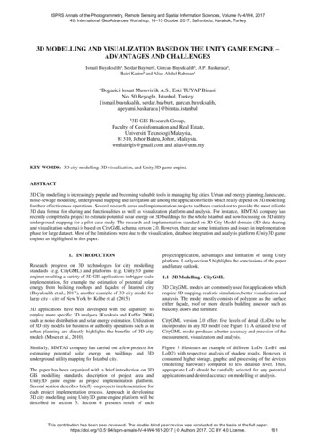
ISPRS Annals of the Photogrammetry, Remote Sensing and Spatial Information Sciences, Volume IV-4/W4, 20174th International GeoAdvances Workshop, 14–15 October 2017, Safranbolu, Karabuk, Turkey3D MODELLING AND VISUALIZATION BASED ON THE UNITY GAME ENGINE –ADVANTAGES AND CHALLENGESIsmail Buyuksaliha, Serdar Bayburta, Gurcan Buyuksaliha, A.P. Baskaracaa,Hairi Karimb and Alias Abdul RahmanbaBogazici Insaat Musavirlik A.S., Eski TUYAP BinasiNo. 50 Beyoglu, Istanbul, Turkey{ismail.buyuksalih, serdar.bayburt, ulb3D GIS Research Group,Faculty of Geoinformation and Real Estate,Universiti Teknologi Malaysia,81310, Johor Bahru, Johor, Malaysia.wmhairigis@gmail.com and alias@utm.myKEY WORDS: 3D city modelling, 3D visualization, and Unity 3D game engine.ABSTRACT3D City modelling is increasingly popular and becoming valuable tools in managing big cities. Urban and energy planning, landscape,noise-sewage modelling, underground mapping and navigation are among the applications/fields which really depend on 3D modellingfor their effectiveness operations. Several research areas and implementation projects had been carried out to provide the most reliable3D data format for sharing and functionalities as well as visualization platform and analysis. For instance, BIMTAS company hasrecently completed a project to estimate potential solar energy on 3D buildings for the whole Istanbul and now focussing on 3D utilityunderground mapping for a pilot case study. The research and implementation standard on 3D City Model domain (3D data sharingand visualization schema) is based on CityGML schema version 2.0. However, there are some limitations and issues in implementationphase for large dataset. Most of the limitations were due to the visualization, database integration and analysis platform (Unity3D gameengine) as highlighted in this paper.1. INTRODUCTIONResearch progress on 3D technologies for city modellingstandards (e.g. CityGML) and platforms (e.g. Unity3D gameengine) resulting a variety of 3D GIS applications in bigger scaleimplementation, for example the estimation of potential solarenergy from building rooftops and façades of Istanbul city(Buyuksalih et al., 2017), another example of 3D city model forlarge city – city of New York by Kolbe et al. (2015).3D applications have been developed with the capability toemploy more specific 3D analyses (Kurakula and Kuffer 2008)such as noise distribution and solar energy estimation. Utilizationof 3D city models for business or authority operations such as inurban planning are directly highlights the benefits of 3D citymodels (Moser et al., 2010).Similarly, BIMTAS company has carried out a few projects forestimating potential solar energy on buildings and 3Dunderground utility mapping for Istanbul city.The paper has been organized with a brief introduction on 3DGIS modelling standards, description of project area andUnity3D game engine as project implementation platform.Second section describes briefly on projects implementation foreach project implementation process. Approach in developing3D city modelling using Unity3D game engine platform will bedescribed in section 3. Section 4 presents result of eachproject/application, advantages and limitation of using Unityplatform. Lastly section 5 highlights the conclusions of the paperand future outlook.1.1 3D Modelling - CityGML3D CityGML models are commonly used for applications whichrequire 3D mapping, realistic simulation, better visualization andanalysis. The model mostly consists of polygons as the surfaceeither façade, roof or more details building assessor such asbalcony, doors and furniture.CityGML version 2.0 offers five levels of detail (LoDs) to beincorporated in any 3D model (see Figure 1). A detailed level ofCityGML model produces a better accuracy and precision of themeasurement, visualization and analysis.Figure 5 illustrates an example of different LoDs (LoD1 andLoD2) with respective analysis of shadow results. However, itconsumed higher storage, graphic and processing of the devices(modelling hardware) compared to less detailed level. Thus,appropriate LoD should be carefully selected for any potentialapplications and desired accuracy on modelling or analysis.This contribution has been peer-reviewed. The double-blind peer-review was conducted on the basis of the full -161-2017 Authors 2017. CC BY 4.0 License.161
ISPRS Annals of the Photogrammetry, Remote Sensing and Spatial Information Sciences, Volume IV-4/W4, 20174th International GeoAdvances Workshop, 14–15 October 2017, Safranbolu, Karabuk, Turkeyoffered to the user in the scene. Standard mapping functions suchas projection system, information, and on-off layer are builtbased on the Unity platform. Specific function such as query,shadow calculation, solar radiation and sun locator and angle arebeing embedded in the equations and internal codes (not in theviewer).1.2.2Figure 1. The LoDs concept in CityGML v2.0 standard (Kolbeand Bacharach, 2006).1.2 Unity3D Game EngineBuilt-in AnalysisUnity game engine provides a platform either to use their librariesor our own codes for supporting application analysis.Built-in analysis such as estimating solar potential project usesseveral available libraries and localizes algorithms includingeffectiveness of roof-mounted and façade-mounted system, usingphotovoltaic (PV) and thermal. The project also implementedsome related methods on solar analysis available in others solarestimation application - shadow calculation, sunlight locationand angle, direct or indirect reflection and others.Unity is a cross-platform game engine designed to support anddevelops 2D and 3D video games, simulations for computers(e.g. Figure 2), virtual reality, consoles and mobile devicesplatform (Unity, 2017). It is commercial software developed byUnity Technologies. Unity 3D provides three dimensionalmanipulation and simulation through functions defined usingprogramming languages.1.3 Project Implementation AreaThe engine capable of making high quality games, design anddevelop 3D social network gaming platforms (Bae and Kim,2014). In addition, 3D visualization, functions and attributes,intelligence and metric measurements can be done with Unity 3Dencoding.The first project is to estimate potential solar energy buildings,covers the whole Istanbul (5,400 square kilometres, around 1.5million buildings) as illustrate see Figure 3. The project usesLoD2 and LOD3 CityGML standards as 3D city model schema.Building models can be extracted from both aerial images andLiDAR data (Wang et. al, 2008). Digital Surface Model (DSM)and Digital Elevation Model (DEM) for the whole Istanbul wereacquired by the previous project (data collection using AirborneLiDAR), two years ago.The second project focuses on customization of 3D undergroundutility mapping and tools to support several 3D undergroundanalyses. The Figure 4 shows the utility network over the city.Figure 2. Examples of 3D scenes from Unity’s sample projects(Unity, 2017)Unity has three important components (Unity, 2017); A game engine: This allows the games to be created,tested and played in different environments. An application where the design or the user interface isput together with a graphics preview option and controlplay function. A code editor: The IDE provides a text editor to writecode. However, a separate text editor is often used toavoid confusion.Figure 3. Istanbul province as the first project (estimating solarenergy) study area.Unity is an excellent platform to start game development anddefinitely recommended for developers who want to jump startgame development. Unity provides numerous tutorials basedvideo examples that make a developer familiar with thedevelopment process.1.2.1Built-in Game & Map FunctionsFigure 4. 3D underground utility mapping.Unity3D features such as flight, rotation, pan, zoom in and zoomout can be used. The camera, light and other types of objects areThis contribution has been peer-reviewed. The double-blind peer-review was conducted on the basis of the full -161-2017 Authors 2017. CC BY 4.0 License.162
ISPRS Annals of the Photogrammetry, Remote Sensing and Spatial Information Sciences, Volume IV-4/W4, 20174th International GeoAdvances Workshop, 14–15 October 2017, Safranbolu, Karabuk, Turkey2. PROJECTS IMPLEMENTATION3. 3D GIS MODELLING IN UNITYThis section is divided into two subsections - estimating potentialsolar energy 3D city modelling and 3D underground utilitymapping.As industry experts and connoisseurs of the tool, they explainedthat one of the biggest beneficiaries of using Unity3D is Android.Being, in the market with more users and more devices incirculation has many advantages. This is especially reflectedwhen analysed from a social point of view.2.1 Estimating Potential Solar Energy – 3D IstanbulSolar energy modelling is increasingly popular, important, andeconomic significant in solving energy crisis for big cities. It is aclean and renewable resource of energy that can be utilized andsolving power crisis to accommodate expansion of urban and thegrowth of population. However, as the spaces for solar panelinstallation in cities are getting limited nowadays, the availablestrategic options are only at the rooftop and façade of thebuilding. Thus, accurate information and selecting building withthe highest potential solar energy amount collected is essential inenergy planning - installing photovoltaic (PV) system and panels.Sunlight comes to the earth as a form of electromagneticradiation. Solar energy is radiant light and heat from the sunwhich is very beneficial and crucial as renewal energy. Solarenergy radiation at earth’s surface varies due to absorption,scattering, reflection, change in spectral content, diffusecomponent, water vapour, clouds pollution, shadow (Figure 5)and others (Alam et. al.,2013).Unity is an excellent platform to start game development anddefinitely recommended for developers who want to jump startgame development. Unity provides numerous tutorials basedvideo examples that make a developer familiar with thedevelopment process. Rendering: The Unity graphics engines use OpenGL,Direct3D, OpenGl ES for mobile platform (iOS,Android) and various APIs. There is also support ofreflection, parallax and bump mapping. It providesfeatures to render text and use of shadow maps fordynamic shadows. Various file formats of differentsoftware are supported. For instance, Adobe Photoshop,Blender and 3ds Max are supported. Scripting: Scripting is built on Mono, the open sourceplatform for.NET Framework. Programmers write theUnityScript similar to JavaScript, C sharp and Boo. Physics: The Unity engine provides built-in support forPhysX physics engine with real time cloth simulation onskinned meshes, collision layers and thick ray casts.The project was completed in two years; starting from convertingCityGML data LoD2 – LoD3 (with photos) into Unity supportedformats (e.g. in this project mostly use .fbx format). The finalresults (estimated potential solar energy for each building façadeand rooftop) are acquired via implementation flow as illustratedin Figure 6.3.1 Pre-Processing Flow (Preparing input data)Figure 5. Effect of LoD1 and LoD2 in shadow calculation.(Biljecki et. al., 2013).Solar potential analysis can be used to localize the mostsuited areas on a building in its urban (Good et. al., 2014).Several method of solar analysis was proposed in Good et. al(2014). The project also implemented some related methods onsolar analysis available in others solar estimation application.They are shadow calculation, sunlight location and angle, director indirect reflection and others.The implementation of this solar estimation project for Istanbuluses CityGML LoD2-LoD3. The model and analyses werecarried out using Unity3D game engine with development ofseveral customized tools and functionalities.2.2 3D Underground Utility MappingThe aim of the project is to provide the 3D modelling of thenatural gas network with integration of the pipelines on 3D CityModelled Map. Natural gas network can be built by integrating3D models metric and geometrically with high precision and 3Dcity model created in Unity 3D software (Windows application).Figure 6. Pre-processing phase for unity input model.This contribution has been peer-reviewed. The double-blind peer-review was conducted on the basis of the full -161-2017 Authors 2017. CC BY 4.0 License.163
ISPRS Annals of the Photogrammetry, Remote Sensing and Spatial Information Sciences, Volume IV-4/W4, 20174th International GeoAdvances Workshop, 14–15 October 2017, Safranbolu, Karabuk, Turkey3.2 Customized GUI and Functionalities3.2.1Estimating Solar Energy ProjectThe custmized Unity application was named as Istanbul GunesEnerjisi Verimliligi as default view in Figure 7.Figure 8. 2D utility layer in shapefile format.4. MODELLING OUTCOMES, ADVANTAGES ANDLIMITATAIONS OF USING 3D UNITY GAME ENGINEFinal outcomes are presented in section 4.1, while advantagesand limitations are discussed in the sections 4.2 and section 4.3respectively.4.1 Outcomes4.1.1Estimating Solar Energy ProjectFigure 7. Default GUI view of Istanbul Solar Estimation.3.2.23D Underground Utility MappingConversion of CityGML data to Unity supported format (.fbx),projection, orthophoto images and basic mapping tools (zoom-in,pan, rotate, selection of object and others) has been completed.However the customized functions (see Figure 8) for supportingunderground utility is still in progress.The outcomes show the estimation of potential solar energyreceived for the whole area by day, week, month and year, thusthe decision for installing the solar panel. Calculation of theenergy will be made based on the rooftops or/and façades of aselected building. Figure 9 and Figure 10 show a selectedbuilding with rooftop as solar panel just before and after thecalculation take place. While Figure 11 shows the calculation(estimation of potential solar energy received by) on the selectedbuilding façades.3.3 ChallengesEstimating the solar energy/radiation from rooftops and facadeshas some limitations – e.g. the shadows from other neighbouringbuildings. One of the biggest issues in solar radiation calculationin urban area is shadow casting. It affects the accuracy of thepotential radiation results as for high storeys buildings. The sizeand position of the shadow caster directly impact on energycollection (Alam et. al., 2013). Solar irradiance can be estimatedwhile incorporate shading effects of surrounding buildings withgenerated lines pointing towards the direction of the sun at thespecific points in time (Wieland et. al., 2015). Alam et. al (2013)uses potential building surfaces of the city model (CityGML) andsub-divided them into triangles again and again into smallertriangle like octree hierarchical process. The coverage of thetriangles (every level) will determine the solar irradiance ofparticular CityGML building surfaces.For the 3D underground utility mapping, data interoperability ofthe utilities layer (pipeline, gas and others) is one of thehighlighted challenges. Layers need to be prepared in validtopological elements (e.g. not intersect 3D, connected network)and it was extracted from shapefile format (.shp). Convertingformat 2D shp to 3D fbx format is one of the difficulties of thisproject.Figure 9. Selection of a particular building to be calculated.This contribution has been peer-reviewed. The double-blind peer-review was conducted on the basis of the full -161-2017 Authors 2017. CC BY 4.0 License.164
ISPRS Annals of the Photogrammetry, Remote Sensing and Spatial Information Sciences, Volume IV-4/W4, 20174th International GeoAdvances Workshop, 14–15 October 2017, Safranbolu, Karabuk, TurkeyFigure 14. 3D visualization of underground utility (gas).4.2 Advantages of 3D modelling in UnityFigure 10. Solar estimation for the selected building rooftop.The main advantage of Unity3D is that it can run on multiplatform with online and offline modes on Windows, Mac,Linux and mobile platform (Ruzinoor et. al., 2014). Most ofUnity 3D development projects are based on Android platformdue to integration simplicity. Unity also allows user to publishthe developed games on other platforms such as iPhone andWindows phones or tablets with large number of users. The gameengine also capable of importing other 3D models in FBX, SBXand OBJ formats.Unity 3D game engine provides good visualization and lightrendering of 3D objects, thus major advantage for modelling 3Dspatial geometry. It provides variety of functions and moduleslibrary for multi specifications of the gaming development (Baeand Kim, 2014).Figure 11. Solar estimation for the selected building façade(potential solar panel).4.1.23D Underground Utility Mapping ProjectThis is a ongoing project - visualization of 3D buildings and datamodelling (orthophoto-terrain and underground cables) are inprogress as shown in Figure 12, 13 and 14 respectively.For these two projects, Unity 3D provide a flexible platformespecially to customize appropriate functions and modules forapplication needs. As compared subscribing commercialsoftware such as AutoCAD Map and ESRI City Engine, onlydefault functions are available.4.3 Limitations of 3D modelling in UnitySome general limitations for Unity 3D are as listed below: It does not allow developer to start from a foundation ortemplate. Any game or project needs to be implemented fromscratch to the detailed functions with GUI. From a graphical point of view, Unity game platformperforms slower than other engines such as UDK (UnrealDevelopment Kit). High costs.Other specific limitions on 3D modelling (mapping context) willbe highlighted in the following sub-sections.4.3.1Figure 12. 3D visualization of 3D terrain information.No Coordinate Transformation ProjectionsMost of the 3D modelling software could not cope with spatialdata is because of the projection system. Unity also did notsupport coordinate system as for their libraries/modules. Thereare no transformation tools or libraries for coordinate’sconversions.4.3.2Format Interoperability Problems (GIS)The Unity 3D game engine supports very limited input formatse.g. .fbx, .sbx and .obj which focuses on geometry; vertex andfaces ordered. Thus, creates limited interoperability duringconversion process such as loss of semantic and attributes(information in the column fields).Figure 13. 3D visualization of underground utility (gas).This contribution has been peer-reviewed. The double-blind peer-review was conducted on the basis of the full -161-2017 Authors 2017. CC BY 4.0 License.165
ISPRS Annals of the Photogrammetry, Remote Sensing and Spatial Information Sciences, Volume IV-4/W4, 20174th International GeoAdvances Workshop, 14–15 October 2017, Safranbolu, Karabuk, Turkey4.3.3Single / stand-alone file and Limited DatabasesSupportUnity uses only a single file (or single file directory) to store allthe codes, functions, GUI properties as well as the datasets (2Dand 3D) of a project, thus consumes huge memories (RAM andROM) of the computer system. Other disadvantage – it is a standalone system which hardly able to integrate with other softwaresuch as database.4.3.4Less Users, Documents and Supports for 3DMappingUnity is designed for game development where most of themanuals, tutorials and sample projects are associated with thegaming specifications and developments. The game engine canbe considered as very specialized tool for 3D visualization ofspatial objects. It has various limitations and other drawbacks,thus very limited users, documents and supports.4.4 3D Game Engine for 3D GIS VisualizationThis section describes the potential of 3D Unity visualization andgame engine for 3D GIS visualization. There are severalvisualization packages meant for GIS, however most of thosepackages have very limited functionality for 3D GIS modellingand visualization, e.g. ArcScene, Bentley Map, MapInfoDiscover 3D, AutoCAD Map 3D as reported during theworkshop (TU Delft, 2011) as well as by Abdul Rahman (2016).The development of 3D visualization from those packages is stillin progress and working toward solutions for ‘real’ 3D GISvisualization requirements.3D spatial database component is quite essential in any spatialinformation system. We anticipate those two projects could beextended for a bigger scope in 3D spatial database component,i.e. providing answers for spatial and non-spatial queries of 3Dobject. We also recommend a transformation of 3D objects(CityGML) into GIS-based layers where more spatial or/andspatio analysis could be carried out on the layers.All these layers from two different projects (solar energyestimation and underground utility) would be useful for futureGIS-based smart city – planning and management. Later, new 3Dlayers or objects could be added or integrated to provide multifunctional applications within a single smart city model, in thiscase - 3D Unity.5. CONCLUSIONSWe have described the 3D modelling for estimating potentialsolar energy on buildings surfaces and underground utilitymapping using Unity 3D game engine platform for Istanbul.These applications provide precise measurements (e.g. solarenergy estimation and location of underground utilities), analysisand better visualization especially for city planners.Some advantages and limitations of the game engine alsohighlighted. The Unity 3D game engine itself is the most highquality game engine available in the market, easy to use andshorter rendering duration are mostly suite for game developersand companies. We strongly believe this 3D game engine couldbe extended for better visualization, format interoperability,database and other spatial related functions or applications in thenear future.REFERENCESAbdul Rahman, A., (2016). Recent Research Works on 3D GIS inMalaysia. Keynote paper, International Conference on Geomatic andGeospatial Technology (GGT) 2016. 5 – 6 October 2016. Kuala Lumpur,Malaysia.Alam N., V. Coors, and S. Zlatanova, 2013. Detecting shadow for directradiation using CityGML models for photovoltaic potentiality analysis.UDMS Annual 2013. Publisher: Taylor & Francis Group, London, UK,Editors: Claire Ellul, Sisi Zlatanova, Massimo Rumor, Robert Laurini,pp.191-210Bae J.H and A.H. Kim, 2014. Design and Development of Unity 3DGame Engine-Based Smart SNG (Social Network Game). InternationalJournal of Multimedia and Ubiquitous Engineering. Vol. 9, No. 8 (2014),p.p 261-266.Biljecki, F., J. Stoter, 2013. The Concept of LoD in 3D city models. In:Proceedings of Workshop CityGML in national mapping, 21- 22 January,2013, Paris, France).Buyuksalih G., S. Bayburt, A.P. Baskaraca, Hairi Karim and Alias AbdulRahman. 2017. International Geomatic and Geoinformatic Technology,ISPRS Achieve. 03-04 October 2017, Kuala Lumpur. [In Press].Good C.S., G. Lobaccaro, and S. Hårklau, 2014. Optimization of solarenergy potential for buildings in urban areas – a Norwegian case study.Renewable Energy Research Conference, RERC 2014. ScienceDirect,Energy Procedia 58 ( 2014 ) 166 – 171.Kolbe T., B. Burger., and B. Cantzler. 2015. CityGML goes to Broadway.In: D. Fritsch. Photogrametric Week’15. Wichmann, Stuttgart, Germany.Pp 343-355.Kolbe T. and Bacharach S., 2006. CityGML: An Open Standard for -for-3dcity-models/123103 [Cited: June 15, 2017].Kurakula V., Kuffer, M., 2008. 3D Noise Modeling for UrbanEnvironmental Planning and Management. Real Corp 2008 Proceedings,Vienna.Moser J., F. Albrecht and B. Kosar, 2010. Beyond Visualisation – 3D GisAnalyses for Virtual City Models, ISPRS Archives, Volume XXXVIII4/W15. 5th International 3D GeoInfo Conference, November 3-4, 2010,Berlin, Germany.Ruzinoor C. M., M. Shariff A. R., A. N. Zulkipli., M. Rahim M. Shafry,and M. H. Mahayudin, 2014. Using game engine for 3D terrainvisualisation of GIS data: A review. 7th IGRSM International RemoteSensing & GIS Conference and Exhibition, Kuala Lumpur. IOP Conf.Series: Earth and Environmental Science 20 (2014) 012037doi:10.1088/1755-1315/20/1/012037Šúri M. and J. Hofierka, 2004. A New GIS - based Solar RadiationModel and Its Application to Photovoltaic Assessments, Transactionsin GIS, vol. 8, no. 2, pp.175 –190, 2004.TU Delft, 2011. 2nd International Workshop on 3D Cadastres. Organizedby FIG, EuroSDR and TU Delft, 16-18 November 2011, Delft, TheNetherlands.Unity, 2017. Unity Documentation - 2Dhttps://docs.unity3d.com/ [Cited: June 10, 2017].or3Dprojects.Wang Y., S. Schultz, F. Giuffrida, 2008. Pictometry's ProprietaryAirborne Digital Imaging System and Its Application in 3D CityModelling. Commission I, ThS-2, ISPRS Vol. XXXVII. Part B1. Beijing,2008.Wieland M., A. Nichersu, S. M. Murshed, and J. Wendel. 2015.Computing Solar Radiation on CityGML Building Data. AGILE 2015 –Lisbon, June 9-12, 2015This contribution has been peer-reviewed. The double-blind peer-review was conducted on the basis of the full -161-2017 Authors 2017. CC BY 4.0 License.166
Unity is an excellent platform to start game development and definitely recommended for developers who want to jump start game development. Unity provides numerous tutorials based video examples that make a developer familiar with the development process.