Transcription
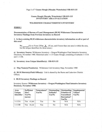
Page 1 of 7 Guano Slough (Murphy Waterholes)/ OR-015-115Guano Slough (Murphy Waterholes)/ OR-015-115INVENTORY AREA EVALUATIONWILDERNESS CHARACTERISTICS INVENTORYFORMlDocumentation of Bureau of Land Management (BLM) Wilderness CharacteristicsInventory Findings from Previous Inventory on Record1. Is there existing BLM wilderness characteristics inventory information on all or part ofthis area?No (Go to Form 2)Yes x (If yes, and if more than one area is within the area,list the unique identifiers for those areas.)a) Inventory Source: Wilderness Inventory- Oregon/Washington Final Intensive InventoryDecisions, November 1980. Historical units 1-115 Guano Slough, consisting of subunits 1-11 SAand 1-115B.b) Inventory Area Unique Identifier(s): OR-015-115c) Map Name(s)/Number(s): Wilderness Unit Inventory Map, November 1980d) BLM District(s)/Field Office(s): Unit is shared by the Burns and Lakeview DistrictOffices.2. BLM Inventory Findings on RecordInventory Source: Wilderness Inventory - Oregon/Washington Final Intensive InventoryDecisions, November es)Naturalness?Yes/No1-l 15AYes 47,360Yes1-115BYes 59,120YesOutstanding Outstanding SupplementalPrimitive & Values?Solitude?Unconfined Yes/NoYes/NoRecreation?Yes/NoNIANIANoNoNIANIA
Page 2 of 7 Guano Slough (Murphy Waterholes)/ OR-015-115Unit 1-115Subunits: The unit contained 106,480 acres. During the intensive inventory Unit 1-115 wasfound to be divided by roads 7155 A and B into two subunits.Unit 1-115ASize: Public land comprised 47,360 acres. The subunit contained three full sections of State landand a 960-acre block of private land.Location: The unit was adjacent to the east boundary of Hart Mountain National AntelopeRefuge.Boundaries: Frenchglen Road and the boundary of Hart Mountain National Antelope Refuge.The remaining boundaries were BLM roads 7185B, 7185C, 6176H, and private lands.Physical Characteristics: The subunit consisted of sage flats on the east and low, rolling hillswith some small, broken r1ms on the west. The highest point on the unit was Cox Butte, whichrises some 300 feet above the surrounding terrain. Vegetation on the unit was a big sagebrushcommunity.Naturalness: The subunit contained 9 major lakebed pits and approximately 9 miles of vehicleways. The overall appearance was generally natural with the works of man substantiallyunnoticeable.Solitude: With the flat to moderately rolling terrain in the unit and high visibility of personsmoving within it, the unit did not offer outstanding opportunities for solitude.Recreation: The unit possessed no characteristic landscape feature or particular point of interestthat would appeal to the general wilderness recreationist. The unit had a high potential forantelope hunting, but this was not considered a form of primitive recreation as practiced in theregion because it depended on motor vehicles.Supplemental Values: None known.Proposed Decision: Eliminate from further review.Unit 1-115BSize: The unit contained approximately 59,120 acres of public land, with two complete sectionsof State inholdings and approximately 680 acres of small, scattered tracts of private land near thesouth boundary. These tracts were all less than 120 acres.Location: The unit was adjacent to the east side of Hart Mountain National Antelope Refuge .
Page 3 of 7 Guano Slough (Murphy Waterholes)/ OR-015-115Boundaries: The west boundary was the Hart Mountain National Antelope Refuge and BLMRoad 6176A. The remaining boundaries were private and State lands, and BLM roads 6176,7185, and 7185C. BLM road 7185A from Cox Butte Waterhole to Socket Waterhole intrudedinto the subunit for approximately 8.5 miles.Physical Characteristics: The unit was essentially a very broad, sage covered basin with littletopographic relief. Guano Slough and Black Canyon cross the southern third of the subunit.Black Canyon was approximately 6 miles long, approximately 100 feet deep at the maximum,and less than several hundred feet at the widest point. The canyon had vertical basalt walls alongmost of its length with several small side canyons. The subunit contained numerous ephemerallakes; most had been developed to provide stock water.Naturalness: The dead-end road mentioned under boundaries was very noticeable. The subunitcontained 8 moderate to large lake bed pits and approximately 9 miles of vehicle ways. Therewas an emergency airfield located near the south boundary. There was a small quarry site 2miles west of Guano Reservoir. The man-made features had a minor cumulative impact on theunit; however, they remained substantially unnoticeable because of the large size of the subunit.Solitude: A person would have a feeling of isolation in the unit but the arrival of others in thearea would be immediately noted. One could hike in Black Canyon and gain some sense ofsolitude but only extremely limited user capacity would allow for solitude. This subunit did notoffer an outstanding opportunity for solitude.Recreation: The Black Canyon area was of some geologic interest and offered opportunities forwildlife observation, notably of cliff dwelling birds. However, the opportunity was notconsidered outstanding. Opportunities for hiking and backpacking in the unit were notoutstanding because there was no unique or noteworthy feature which would attractrecreationists and cause the recreation opportunities to stand above others of their kind.Supplemental Values: Black Canyon was of some geologic interest, and the area was expectedto contain some archeological sites though none were documented.Final Decision: Eliminate both subunits from further review.Rationale: After reviewing the public comments and re-evaluating the unit in the field, the BLMcontinued to believe the unit did not offer outstanding opportunities for solitude and recreation.The broad, open expanses of the unit as a whole offered very few opportunities to avoid others inthe unit and little recreation opportunity. The canyon area did offer some recreation potential andlimited opportunity for solitude, as stated in the initial evaluation. However, a joint re assessment of the unit by Burns and Lakeview District personnel confirmed that, though thecanyon offered some recreation potential, it was not outstanding in character.
Page 4 of 7 Guano Slough (Murphy Waterholes)/ OR-015-115FORM2Current Conditions: Presence or Absence of Wilderness CharacteristicsArea Unique Identifier OR-015-115Acreage100,7931. Is the area of sufficient size? (If the area meets one of the exceptions to the size criterion,check "Yes" and describe the exception in the space provided below.)YesxNo1980 Assessment: This unit began as unit 1-115 with 106,480 acres in the final decision of theinitial wilderness inventory of 1979. During the intensive inventory of 1979 unit 1-115 wasfound to be divided by roads 7155A and 7155B and subsequently divided into two subunits: 1115A and 1-115B.In 2007, the Oregon Natural Desert Association (ONDA) submitted citizen proposed lands withwilderness characteristics to the Burns BLM. Unit 1-115 was not included in their submittal.In 2013 Burns District responded to a request from the Lakeview District to conduct routeanalysis and wilderness character inventories for units shared by both districts. A route analysiswas completed for unit 1-115, although wilderness character was not assessed at that time.2017 Evaluation: The Burns and Lakeview Districts made the determination they wouldcomplete the inventories of units shared by both districts.The unit is bounded on the north by Rock Creek Lane (412) and U.S. Fish and Wildlife Servicelands. On the west side the unit is bounded by U.S. Fish and Wildlife Service lands and BlackCanyon Road (6176-KO). The south side of the unit is bounded by private lands, Black CanyonRoad (6176-KO), Red Hills Road (6176-JO) and West Guano Slough Road (8249-AO).2. Does the area appear to be natural?YesxNoNIA- - - -1980 Assessment: The 1980 wilderness inventory described subunit 115A as in a generallynatural condition with 9 lakebed pits and approximately 9 miles of vehicle ways. Those featureswere determined to be substantially unnoticeable. Subunit 115B was also described as being in anatural condition. The inventory mentions 8 moderate to large lakebed pits and about 9 miles ofvehicle ways. There is also a small airfield on the southern boundary of unit 115B and a small ·quarry located 2 miles west of Guano reservoir.2017 Evaluation: Unnatural features in the unit include 11 waterholes, 4 reservoirs, 13.2 milesof fences and a quarry that was mentioned in the 1980 inventory. Vegetation has overgrown thequarry and it is no longer visible as an unnatural feature. The unnatural features are substantiallyunnoticeable. The unit remains in a natural condition.
Page 5 of 7 Guano Slough (Murphy Waterholes)/ OR-015-1153. Does the area (or the remainder of the area if a portion has been excluded due tounnaturalness and the remainder is of sufficient size) have outstanding opportunities forsolitude?YesxNoNIA- - - -1980 Assessment: The 1980 Wilderness Inventory described outstanding opportunities in thefollowing manner:Unit 1-115A noted, "With the flat to moderately rolling terrain in the unit and high visibility ofpersons moving within it, the unit does not offer outstanding opportunities for solitude."Unit 1-115B noted, "A person would have a feeling of isolation in the unit but the arrival ofothers in the area would be immediately noted. One could hike in Black Canyon and gain somesense of solitude but only extremely limited user capacity would allow for solitude. This subunitdoes not offer an outstanding opportunity for solitude."2017 Evaluation: Waterholes, canyons, and drainages in the unit provide low-lying areas wherevisual screening is available to visitors. Cox Butte, which stands out in the unit due to its size andelevation, provides topographic screening to visitors who ascend its slopes and recreate on theplateau that overlooks the rest of the unit. The unit is approximately 14 miles by 12 miles. Anindividual in the center of the unit would not be visible to those on the boundary due tovegetative and topographic screening due to the distances involved. Opportunities for solitudeexist throughout the unit. The size of the unit, the diverse topography, and the presence of bothlow and high sagebrush in the unit combine to provide outstanding opportunities for solitude.4. Does the area (or the remainder of the area if a portion has been excluded due tounnaturalness and the remainder is of sufficient size) have outstanding opportunities forprimitive and unconfined recreation?YesxNoNIA- - - -1980 Assessment: The inventory found no outstanding opportunities for primitive andunconfined types of recreation.Unit 1-115A noted, "The unit possesses no characteristic landscape feature or particular point ofinterest which would appeal to the general wilderness recreationist. The unit has a high potentialfor antelope hunting but this would not be considered a form of primitive recreation as practicedin the region because it depends on motor vehicles."Unit 1-115B noted, "The Black Canyon area is of some geologic interest and offers opportunityfor wildlife observation, notably of cliff dwelling birds. However, the opportunity is notconsidered outstanding. Opportunities for hiking and backpacking in the unit are not outstandingbecause there is no unique or noteworthy feature which would attract recreationists and cause therecreation opportunities to stand above others of their kind."
Page 6 of 7 Guano Slough (Murphy Waterholes)/ OR-015-1152017 Evaluation: Recreational activities visitors may participate in include (but are not limitedto) hunting, horseback riding, wildlife viewing, rockhounding, and exploration. These activities(and others) are available at any time a visitor chooses to participate. The antelope refugeadjacent to the unit provides opportunities for hunters to stalk trophy antelope. Cliff dwellingbirds are of interest to bird watchers. The size of the unit and absence of interior roads providesopportunities for visitors to hike cross-country to points of interest such as geologicoutcroppings. Outstanding opportunities for unconfined types of recreation are present in thisunit.5. Does the area have supplemental values (ecological, geological, or other features ofscientific, educational, scenic, or historical value)?YesX---No- - - -NIA- - - -1980 Assessment: Supplemental values within Unit 1-115A were unknown. Unit 1-11 SB notedBlack Canyon was of some geologic interest, and the area would be expected to contain somearcheological sites though none were documented at the time.2017 Evaluation: Supplemental values in this unit would include sage grouse leks, pygmy rabbithabitat, and in Black Canyon there are paleo-environmental sites, as well as highly significantarcheology sites.Summary of Analysis*Area Unique Identifier:OR-01 5-11 5Summary Results of Analysis: The (Guano Slough) Murphy Waterholes Unit meets the sizecriteria. The boundary analysis created a unit of 100,793 acres. The unit appears to be in anatural condition. The unnatural objects and features in the unit are substantially unnoticeabledue to the type of development or because of their location. The unit offers outstandingopportunities for solitude due to its size and topographic and vegetative screening. The rollinglandscape with prominent outcrops and drainages allows visitors to find solitude in manylocations. The size of the unit contributes to these outstanding opportunities. A visitor in onelocation may be completely unaware of visitors in other sections of the unit 10 miles away.These outstanding opportunities extend to unconfined types of recreation. The adjacent HartMountain Antelope Refuge provides outstanding hunting opportunities. The size of the unit alsocontributes to the outstanding opportunities by providing more room to participate. The unit alsoincludes supplemental values. These values include sage grouse leks, pygmy rabbit habitat,archeological sites of high significance, and paleo-environmental sites in Black Canyon. This form documents information that constitutes an inventory finding on wilderness characteristics. It does not-represent a formal land use allocation or a final agency decision subject to administrative remedies under either43 CPR parts 4 or 1610.5-3.
Page 7 of7 Guano Slough (Murphy Waterholes)/ OR-015-1151. Does the area meet any of the size requirements?K., YesNoNIA2. Does the area appear to be natural?x YesNoNIA3. Docs the area offer outstanding opportunities for solitude or a primitive and un onfmedK ,. YesNoNIAtype of recreation?4. Does the area have supplemental values?x YesNoNIACheck One:X The area, or a portion of the area, has wilderness characteristics and is identified as landswith wilderness characteristics.The area does not have wilderness characteristics.Prepared by (Team Members):Tom Wilcox - Wilderness Specialist Burns DistrictChris Bishop - Outdoor Recreation Planner, Lakeview Resource AreaReviewed by (District or Field Manager):Title: Field Manager, Andrews Resource AreaSigflatur !. - lt"- """--.,.:.-:.- . ,QL.:. ---- .,.,."-"':-a;:Date,·Name: Todd ForbesTitle:Signaturo: \o\ \I;:l-d' Manager, Lakeview Resource Area
O -015-115 Murphy Waterholes Wilderness Characteristics Unit MaplffBoundary Roads - 27 MilesInterior Routes - 5.1.2 MilesReservoirs - 7Waterholes - 16l : J.(Draft) Unit Boundary-Right-Of-WayTReservoir Waterholeltl I Seeding Paved or Graveled Road Natural surface---- Primitive or Unknown SurfaceLand AdministrationBureau of Land ManagementU.S. Fish and WIidiife ServiceStateI Privately owned-BLM WIiderness Study Area-··-· Burns-Lakeview BLM Boundary
Inventory Area Unique Identifier(s): OR-015-115 c) Map Name(s)/Number(s): Wilderness Unit Inventory Map, November 1980 d) BLM District(s)/Field Office(s): Unit is shared by the Burns and Lakeview District Offices. 2. BLM Inventory Findings on Record Inventory Source: Wilderness Inventory - Oregon/Washington Final Intensive Inventory