Transcription
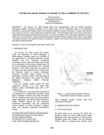
THE SME AVALANCHE TRAGEDY OF JANUARY 20, 2003: A SUMMARY OF THE DATADick Penniman*Snowbridge AssociatesFrank BaumannBaumann EngineeringABSTRACT: On January 20, 2003 guided skiers and snowboarders with the Selkirk MountainExperience (SME) Company climbed a 310 meter long, 36 -37 avalanche slope on TumbledownMountain in the Durrand Glacier area in the Northern Selkirks of British Columbia. In switch back fashiontwo groups of 10 and 11 each followed one after the other. The individuals within each group were told tospace themselves approximately five feet apart. As several members of the lead group reached a convexroll at the top of the slope, a large avalanche released catching thirteen people below. Seven were killed.This paper presents the significant terrain, snowpack, weather, and human factor data that contributed tothis tragic avalanche event.Keywords: couloir, wind-loading, weak layer, terrain risk1. INTRODUCTIONOn January 20, 2003, seven ski tourers,under the leadership of Reudi Beglinger, aSwiss-trained mountain guide and member ofthe Association of Canadian Mountain Guides(ACMG) and the Canadian AvalancheAssociation (CAA), died when they were buriedby an avalanche in the Durrand Glacier area, 35km north northeast of Revelstoke, B.C., Canada(Figure 1). The victims were part of a group of21 skiers that had departed that morning fromthe Durrand Chalet, a remote, helicopteraccessed mountain lodge located at theheadwaters of Cairns Creek, on the west side ofthe Selkirk Mountains, and owned by e.The La Traviata couloir, where the fatalavalanche occurred, is a 310 meter long,shallow, steep, wind-loaded gully with a 37 starting zone.For weeks prior to the avalanche, warnings ofthe presence of a widespread, persistent weaklayer of faceted crystals in the winter snowpackand an overlying snow slab that could producelarge avalanches, were being widely reported inpublic bulletins issued by the CanadianAvalanche Association and the AvalancheControl Section of Parks Canada at RogersPass. The Canadian Avalanche Association’sprivateCorresponding Author Address: Dick Penniman,Snowbridge Associates, P.O. Box 34004,Truckee, California 96160tel: 530.587.0121; fax 587.4313;email: 00 kmVancouverFigure 1: Location of the accident site nearRevelstoke, British Columbia, Canada.data exchange systemwarning of the hazard.(Infoex)wasalso2. CHRONOLOGY OF EVENTS2.1 The Ascent RouteAt about 8:00 am on January 20, 2003, twogroups of skiers (12 led by SME owner, RuediBeglinger, and a second group of 7 skiers led byassistant guide Ken Wylie), left the DurrandChalet (1940 m elevation) and headed north520
down into the headwaters of Cairns Creek. Atthe bottom of the valley (about 1620 m), they puton climbing skins and then ski toured up acrossthe south face of Tumbledown Mountain,heading for a relatively low-angled wooded areaat timberline known as Swiss Meadows (about1900 m). Both the headwaters of Cairns Creek,and especially the south face of TumbledownMountain, are areas where the lack of trees andthe terrain configuration indicates that frequentsnow avalanche activity occurs (Figure 2).Tumbledown MountainGlarona PeakFronalp PeakFatalAvalancheJune 19, 2003Figure 2: Route taken across the south face of Tumbledown Mountainen route to La Traviata couloiron the SME Guide Map. At this juncture,however, Ruedi Beglinger made the decision togo up the La Traviata couloir instead. After ashort break at the same location, the secondgroup followed on the heels of the first group.The two groups of tourers first traversedacross the base of the slope, and then continuedup the couloir as far as they could until theywere under a group of rock bluffs on the westside. They kick turned and traversed backacross the couloir to the rocky ridge on the eastside. At this point they continued to zigzag upthe couloir, making several more kick turnsbefore they reached the top (Figure 3).According to the Coroner’s Report, the skierswere told to stay two meters apart as theyascended the couloir.At the top of the couloir, Ruedi Beglinger,who was well above and ahead of the next skitourer, exited to the east crossing from deep,On the route up to Swiss Meadows,according to one of the ski tourers, the groupcrossed at least one slide track with evidence ofrecent avalanche activity.From Swiss Meadows, the touring groupcontinued up through relatively gentle-slopingand open terrain at the base of the steeperslopes that go up to the long west ride ofTumbledown Mountain. The ascending routewas close enough to the base of the slope that itwas subsequently overrun by the avalanchesthat occurred later that day.At about 2240 meters, the lead group took arest break near the base of a shallow gully (theLa Traviata couloir) that goes up to the westridge of Tumbledown Mountain. Apparently, theobjective up to this point had been to tour up toFronalp Peak, a small 2500 m high summit nearthe west end of the Tumbledown west ridge andthe normal, low angle ascent route as depicted521
Durrand Glacier310 m (1017 feet)37 upper slopeChaletUphill trackJune 19, 2003Figure 3: Looking east at the approximate route taken up the La Traviatacouloir by the SME touring group.At about the same time, the Report statesthat a second smaller slide started lower downon the slope, in rocky terrain between the firstavalanche and the La Traviata couloir where allof the remaining skiers were ascending. A crackalso ran across the entire top of the La Traviatacouloir to the southwest. Where it crossedthrough wind-deposited snow in the gully, itbroke out a 65-meter wide snow slab that variedfrom 63 cm to 260 cm in depth with an averagedepth of 150 cm.The exact sequence of the three avalanchesis not known. The Coroner’s Report suggeststhat the southeasterly slide occurred first, but itis possible that all three slides occurred at aboutthe same time. It is also not certain where thefatal avalanche was triggered. Although theCoroner’s Report stated that it was started bythe first seven ski tourers above the La Traviatacouloir, it is also possible that it was started inwind-deposited snow in the couloir to moreshallow, low angled snow to climber’s right.Seven other members of his group soonfollowed him onto the shallower snow.2.3 The AvalancheAt about 10:45 am according to mountainguide and avalanche instructor Larry Stanier inhis technical report to the Coroner, the seven skitourers who were above the La Traviata couloirheard a sudden “whumpf” and noticed a shift ofthe snowpack. Then a slab avalanche estimatedto be about 50 m wide, 400 m long, and 50 cmdeep moved down the approximately 39 slopeto the southeast of where this group waslocated. At the bottom of the slope, it spread outacross flat terrain, crossing the uphill track madeby the group earlier.522
3. THE TERRAINthe couloir itself by the weight of the rest of theascending party.According to the Coroner’s Report thedimensions of the avalanche debris the LaTraviata couloir was about 185 meters longacross the slope, and about 85 meters wide,with an apparent depth of about 300 cm. If thesefigures are correct, the volume of the debristotaled about 47,000 cubic meters. Using adensity of 0.4 tonnes per cubic meter, the weightof the debris would have totaled approximately19,000 tonnes.The La Traviata couloir where the fatalavalanche occurred is a steep, wind loaded, 310meter long, shallow gully with a 37 startingzone. It is a classic side-loaded gully with a largefetch to windward.3.1 Slope DescriptionThe La Traviata couloir is a south facingtrough-like feature that starts on flat-lying glacialtill deposits located at about 2300 m elevation.The base of the couloir consists of a concavetalus apron that is about 71 meters long, and issloped at an average angle of about 27 . Abovethis, the slope is steeper and more uniform andconsists of colluvial deposits (scree) that go upfor 204 meters at an angle of about 36 , andthen an additional 36 meters at an averageangle of about 37 to a convex roll-over (SeeAppendix 1).Above the convex rollover at the top of thecouloir, the angle of the scree slope decreasesslightly to 34 for 26 meters. Above this, theground consists of broken rock and bluffs thatcontinue up to the ridge crest for 16 meters at anaverage slope angle of 51 . The top of the ridgeis located at an elevation of about 2500 meters.The total length of the slope from the ridge crestto the flat valley bottom is about 350 meters withan average slope angle of about 35 .2.3 The RescueRuedi Beglinger was above the La Traviatacouloir and some distance off to the east sidewhen the avalanches occurred. It is not possibleto determine his exact position, but most likelyhe was about 70 meters north northeast of thecouloir avalanche crown line. One skierestimated that he was about 20 meters from thenext person in the track, and that person wasabout 50 meters up beyond the crown line.From the area where Beglinger stood, hecould not have seen the avalanche crown orlook down the couloir and see the avalanchepath or even the debris where his clients wereburied. There was a short delay as wordreached him of what had happened. Once therealization of what had happened was apparent,however, he and the seven other survivorsmoved quickly down the icy, 37 bed surface towhere the victims were buried.Radio communications were attempted to getassistance with the rescue effort. At 11:05 amSelkirk Tangiers Heli-Skiing (STHS) personneloverheard the radio conversations andvolunteered to send three guides to help. Theywere picked up by Selkirk Mountain Helicoptersat 11:23 but were unable to land until 11:41because of bad weather. They arrived too late tohelp find any but the last victim who was pulledout of the avalanche debris at 11:45.Of the 13 skiers who were caught in theavalanche, six survived and seven died. There issome inconsistency about how many peoplewere totally buried; most likely eight were fullyburied, and five were partially buried. Only oneof the eight skiers who were totally buriedsurvived; he was found 280 centimeters down in30 minutes. Those who died were buried from130 to 280 cm deep.3.2 High Risk Terrain FeaturesThe specific features of this avalanche paththat were indicators of high risk terrain are thefollowing:a) The slope steepness. 60% of allavalanches initiate on slopes of between35 and 40 . The starting zone for the LaTraviata couloir is 36 to 37 .b) Lee slope cross loading. Most avalanchesoccur on slopes where winds cause snowto accumulate to form dense potentiallydangerous snow slabs. The La Traviatacouloir is cross-loaded for nearly its entirelength and has a large area to windward(the fetch) from which significant amountsof snow can be transported withmoderate wind speeds.c) A convex roll at the top. At such places ofconvex curvature, a snow slab resting ona persistent weak layer would be intension due to the difference in the rate of523
Mountains was provided based on data obtainedfrom the Mt. Fidelity remote weather stationlocated at about 1905 meters and some 20 kmeast of the Durrand Glacier and the SelkirkMountain Experience (SME) operation area. Noformal pre-avalanche snowpack data wasavailable or is known to exist from SME as ofthis writing. However, snowpack data from theinvestigation of the crown face of the La Traviatacouloir avalanche was available.snow creep above and below the roll. Askier traversing such a place is morelikely to trigger a release as compared toa flat or concave slope. On the day of thefatal avalanche, the route taken by ReudiBeglinger and his clients traverseddirectly into the wind-loaded convex roll atthe top of the La Traviata couloir.d) Relatively smooth underlying terrain (noanchors). A smooth, scree-covered slopedoes not provide any significantanchoring of the snowpack. The LaTraviata couloir was such a slope.e) Connectivity to an area of shallow snow.In areas where there is continuous snowcover connecting areas of shallow anddeep snow the weight of a person skiinginto the shallower snow where facetedsnow is more likely to develop can causea collapse of the weaker faceted snow.This collapse can then propagate to theslope with a deeper snow slab, triggeringan avalanche. This is more likely tohappen if the snow slab rests on apersistent weak layer such as existed inthe Durrand Glacier area at the time ofthe fatal avalanche. The La Traviatacouloir was adjacent to and connected bysnow cover to the shallower snow of thefetch and upper bench area. A collapse ofthe faceted layer in this area could easilypropagate to the couloir.f) A sudden transition to flat terrain in therunout. An avalanche path with a suddentransition from steep to flat terrain createsa relatively inefficient flow of avalanchedebris in the run out zone. The vastmajority of the energy of the avalanche isdissipated at the transition, causing deepaccumulations of debris at that point. Thelikelihood of a deep burial is increased onsuch slopes when skiers are caught in anavalanche from above. The terrain of theLa Traviata couloir had just such asudden transition at its base where theslope decreased from 27 to nearly 0 over only a few meters. With skiersascending at various elevations up thecouloir, even a small avalanche triggeredfrom above was likely to cause deepburials.4.1 History of the Winter Snowpack in theSelkirk MountainsWinter started in the North Columbiamountains on about November 1, 2002, and byNovember 19, there were 118 cm of snow onthe ground at the Mt. Fidelity study plot. OnNovember 20, 21, and 22, temperaturesremained above freezing and significantamounts of rain, and rain mixed with snow athigher elevations fell. On November 23,temperatures dropped, and a melt-freeze crustformed on the surface of the snow. This curstwas extremely widespread geographically andwas particularly pronounced in the NorthernSelkirk Mountains.Temperatures remained cold from November23 until December 6, when light snow fell andwas deposited on the crust. Cold, clearconditions prevailed until December 10, whichallowed the light snow to change and developfaceted crystals.When new snow started to fall on December10, winds were light, which allowed the facetedcrystals to remain intact and to be buried by newsnow that fell between December 10 and 27(including 40 cm that fell between December 25and 27). The preserved faceted layer is believedto have formed the failure plane on which manysubsequent avalanches, including the ones inthe Durrand Glacier area, ran.4.2 Snowpack Data at the SME Durrand ChaletSME started operations for the season onDecember 28, 2002. On that date, they reporteda total snow depth of 161 cm, including 20 cm ofnew snow. An additional 11 cm of snow wasrecorded between December 28, and January 4,2003, 12 cm between January 12 and 14, andone centimeter of new snow on January 20 (thedate of the fatal avalanche).4. THE SNOWPACKIn the Coroner’s Report a succinct descriptionof the history of the snowpack in the Selkirk524
AVALANCHES: Several size 1 to 1.5 naturaland human triggered avalanches, at tree lineand in the alpine, were reported as recent[ly] asWednesday. These occurrences are nowbecoming isolated as recent storm snowcontinues to bond. A few remotely triggered size2.5 avalanches failed in the Eastern Selkirks,some triggered from over 100 meters away.Widespread whumpfing continues to beobserved in all areas.On January 20, 2003, the total snow depth atthe Durrand Chalet was reported to be 148 cm,indicating that a considerable amount ofsettlement had taken place since weather andsnowpack observation were started onDecember 28, 2002.There is no indication in Larry Stanier’s reportto the Coroner that standard snow profiles wereprepared by SME at the Durrand Chalet studyplot, or that any stability tests were done. Todate no standard snow profiles from SelkirkMountain Experience have been forthcoming.There is no indication in the Coroner’s Reportthat SME reviewed any of the publicly availableavalanche reports for the North ColumbiaMountains. Nor was it reported whether SMEdiscussed snow stability with other nearbyoperations such as Selkirk Tangiers Heli-Skiing.Therefore, it is not known what, if anything, wasdone by SME to evaluate snow stability beforethe group left the Durrand Chalet on the morningof January 20, 2003.4.3 Public Avalanche BulletinWarnings of Avalanche HazardandThe Bulletin also posted the following advisory:TRAVEL ADVISORY: It is important toremember that this El Nino year is producing acomplex and unusual snowpack for themountains of BC. We have two deeply buriedproblem layers that are slow to heal and needour continued attention. Be alert for remotetriggering and continue to be vigilant aboutavoiding those tempting big steep alpine faces.Any avalanche triggered on the olderweaknesses may propagate extensively into alarge and dangerous avalanche event. Be awareof how stresses penetrate deeper into thesnowpack as you group up.OtherOn January 20, 2003 (the day of the fatalavalanche)theCanadianAvalancheAssociation’s Public Avalanche Bulletin for theNorth Columbia Mountains (which includes theSME operating area) warned of a deep-seatedinstability in the snowpack. The Bulletin warnedthat natural avalanches were possible and thatskier-triggered avalanches were probable. ��, midway in the five-class hazardscale. The warning associated with this ratingstated, “Be very cautious in steeper terrain, onlee slopes, or where temperatures are likely toincrease”.The Bulletin for January 17 to January 20provided additional snowpack and avalancheinformation as follows:At Rogers Pass in Glacier National Park,about 30 km from the SME operating area, theAvalanche Control Section of Parks Canada wasalso warning of “Considerable” avalanchehazard. Snow profiles from the AvalancheControl Section were also publicly available fromboth Mt. Fidelity and Mt. MacDonald.In addition to the Public Avalanche Bulletinand the publicly available information fromRogers Pass, the Canadian AvalancheAssociation’s private Information Exchangesystem (Infoex) provided substantial additionalinformation. SME was not a subscriber to thisservice, however, and did not have access tothis information on the day of the fatalavalanche.The presence of the persistent weak layer offaceted crystals described in both Bulletins andInfoex was noted in the snow profiles dug in thevicinity of the La Traviata couloir area byinvestigators working after the fatal avalanche.SNOWPACK: The 15-30 cm of new snow thatfell early in the week continues to settle andbond to the previous surfaces. This new snowhas formed wind slab in exposed areas.Moderate to hard shears are still occurring ontwo surface hoar layers down 70 to 100 cm.Watch for cornices failing with forecasted warmtemperatures, particularly as they can be atrigger for a deep instability, which we certainlyhave this year.5. WEATHERThe La Traviata couloir faces approximatelysouthwest, and the snow pillows and wind rollspresent indicate that it would be wind loadedmost heavily by southeasterly winds that blowacross the south face of Tumbledown Mountain.525
The snow profiles recorded immediately afterthe fatal avalanche show that a considerableamount of wind deposition in the La Traviatacouloir had occurred. Snow depths of up to 260cm were found in the couloir (2475 m elevation),while only 148 cm were recorded at thesheltered snow study plot at the Durrand Chalet(1940 m elevation).The Canadian Avalanche Association’sPublic Bulletin for the North Columbia Mountains(which includes the SME operating area) statedweather conditions between January 17 and 20,2003 as follows:c)d)WEATHER: The strong ridge of high pressureover the south coast and interior BC will persistthrough Friday and Saturday, bringing mainlyclear skies in the alpine and extensive valleyfog. The ridge will begin to give way on Sunday.Expect cooler temperatures in the valley andtemperatures above freezing in the alpine.Winds will be light to moderate from NWthroughout the weekend.e)f)According to the Coroner’s Report, significantwinds (those having velocities of more than 25km/h) were reported on eight separateoccasions between January 1 and 19 on theInfoex system by ski operations in the NorthernSelkirks. Moderate winds are those with speedsof between 26 and 40 km/h, and strong windsare those with speeds of greater than 40 km/h.The significant wind events that occurred wereon January 2 (strong southwest winds); January3 (strong south and southwest winds); January 4(moderate southwest winds); January 7 (strongsouthwest winds); January 8 (moderatenorthwest winds); January 12 (moderate westwind); and January 19 (moderate to strongsouthwest winds).g)h)i)6. THE HUMAN FACTORj)Numerous avalanche books describe basicweather, snowpack, and terrain features that arelikely to increase the risk of avalanches. Thesebooks also describe basic safe travel techniquesthat minimize the risk of being caught or killed inan avalanche. These precepts are universal.The following are some of the most common:a) Before heading out into the backcountry,check and heed the advice of publicavalanche bulletins and other sources.b) Be aware of the underlying groundsurface of potential avalanche slopesk)526and whether terrain features provide anysubstantial anchoring of the snowpack.Track the history of the winter snowpackso that potentially unstable layers orconditions that might cause unusualavalanche activity can be recognizedand managed.Be extra cautious after storms. Mostavalanches occur during or immediatelyafter storm activity, especially if morethan 25 cm of snow has fallen in a shortperiod of time, strong winds have beenpresent, there is a rapid rise intemperatures, or other unusual weatheror snowpack conditions have occurred.Be extra cautious of lingering weaklayers caused by early season coldspells. Faceted crystals inhibit thenatural strengthening of the snowpack.Be wary of wind-loaded lee slopeswhere winds have caused largeramounts of dense snow to form slabs.Note the size of the windward slope orfetch as compared to the area of winddeposit. A small gully or couloir can beloaded quickly by snow transported froma relatively large fetch even withmoderate wind speeds.Be wary in areas where stresses in thesnowpack may be greater, such assteep slopes greater than 30 , convexrolls, and wind loaded slopes.Always consider what would happen toa person if a slope does slide. Deepburials can occur in areas of suddentransition such as benches, creek beds,and flat valley bottoms.Before considering whether or not tocross a slope, consider the remotenessof the location and whether help is near.Consider safer alternatives if the area isremote.If an avalanche slope that may slidemust be crossed, a complete stabilityassessment is critical. All members ofthe group should check rescueequipment, do up clothing, and assurethat a minimum number of people at atime are exposed to the avalanchehazard. Take advantage of islands ofsafety, move as quickly as safelypossible, and be prepared to carry out arescue should it be necessary.Stay away from the base of largeavalanche slopes when traveling in thevalley bottom. Try to stay out of the
assessments and decisions for personal safety,guides do not normally tolerate any independentaction by the clients. From the first author’spersonal experience, this is especially true of theSelkirk Mountain Experience where the guide’sword is law, and if a client falters, he often isquite literally left behind.At least two of the SME clients involved in thefatal avalanche in the La Traviata couloir onJanuary 20, 2003 were former students ofavalanche safety courses personally conductedby the first author. They both had been taughtand knew the basic precepts of recognizingavalanche terrain and of safe winter travel. Bothpracticed these precepts successfully in theirpersonal back county endeavors. Yet they bothconsciously decided to surrender their owndecision-making abilities to the SME guides onJanuary 20, 2003. One paid for that decisionwith her life.potential run out zone where possible.Where it is not, move quickly, exposingas few people to the hazard as possible.From the information available, it appearsthat both the SME guides and the clients ignorednearly all of these precepts.6. DISCUSSIONIt is clear from the data that the La Traviatacouloir presented high-risk terrain to the SMEtouring group. Considering the public bulletinsthat warned of one or more lingering weaklayers in the snowpack at isolated locationsthroughout the Selkirk Mountains, the wisdom ofdeciding to ascend the La Traviata couloir mustbe examined critically so as to avoid, if possible,tragedies of this magnitude in the future.Clearly the SME guides did not heed thewarning signs or at the very least, did not feelthat they were applicable to their group or the LaTraviata couloir on January 20, 2003. Neitherdid they feel the need to follow long establishedprecepts in safe winter travel. Placing the weightof as many as 21 closely spaced people on sucha slope seems a flagrant violation of the mostbasic of safe winter travel precepts.Yet one must consider the context withinwhich this tragedy unfolded. Commercial backcountry operations, whether they be heli-skiingcompanies or ski touring operations like theSelkirk Mountain Experience must be profitableto survive. There is competition from othercompanies to consider. Sudden illness, injury,and equipment failure are additional worries.Differences in skill and fitness levels amongclients complicate matters further.A high client-to-guide ratio allows the largestnumber of people to participate in theseactivities at the lowest possible monetary cost.But with increased group size comes slowermovement and a higher risk that if there is amishap, more people will be affected. Finding abalance between profit and safety is thechallenge all backcountry operators face, and itis arguably not an easy one.Another central question that arises from theLa Traviata tragedy is what responsibility a clienthas for his or her own safety while being in aguided group. In unfamiliar terrain, andespecially with glacier travel or inclementweather conditions, the client is quite dependenton the guide to select the safest routes. Evenwere a client to be familiar enough with theterrain to be able to make independent7. CONCLUSIONAs much as one might believe in takingpersonal responsibility for ones own actions inall circumstances, this is not always possible. Aclassic example of this fact is found in publictransportation. Once one makes the decision toboard an airplane (or helicopter) for example,virtually all safety concerns are handed over tothe pilots, flight attendants, and the mechanicswho serviced it. This is true of trains, buses,boats, and even taxis where passengersconsciously or otherwise give the engineers,drivers, and captains significant responsibility fortheir safety.While it may seem different in a guided skitouring or heli-skiing setting where one ismoving under one’s own power, it is not.Especially where there may be hiddencrevasses or obscured visibility or “white-out”conditions, the client must place his or hercomplete trust in the guide to choose safe routesthrough the terrain and be up to speed oncurrent snowpack conditions and avalanchepotential.The technology does not yet exist, however,to monitor and measure the snowpackeverywhere and at all times. The mountainsnowpack is infinitely variable over time andspace and is, by definition, unknowable. What isknowable is the terrain. Nearly always, simplemeasurements of slope angle, and observations527
why she died while under the professionalguidance of one of the most respected mountainguides in Canada was the driving force behindthis paper. It is the sincere hope of Kathy’sfamily and friends that the lessons learned fromKathy’s death and the death of the other sixvictims will cause positive changes in theprofessional guiding community and the mannerin which they conduct their professional guidingactivities in the future.of wind-loading and slope configuration can beused to identify and avoid high-risk avalancheterrain. When there is any doubt about thestrength of the snowpack, terrain must dictateproper route selection.The CAA and Rogers Pass warningsprovided ample doubt about snowpack strengthin the SME operating area on January 20, 2003.It is clear that the SME guides had not beenrecording snowpack data for the area of the LaTraviata couloir and did not know of (or chose toignore) the weak layer(s) in the snowpack onthat day. But the high-risk nature of the terrainwas obvious from even cursory observations. Byany standard, choosing to ascend the LaTraviata couloir with 21 closely spaced peopleon that day was a human failure.This avalanche tragedy demonstrates thatlike anyone, on any given day, at any given time,and for any reason (no matter how grand ortrivial) even the best guide may not be paying asmuch attention to client safety as is necessary.In most cases surrendering one’s own decisionmaking abilities to those of the guide isdemanded and is arguably the single greatestrisk-decision one makes when choosing topartake in commercial, guided outdoor activities.Lessons from the SME avalanche tragedy ofJanuary 20, 2003 need to be studied,understood, learned, and passed on to theprofessional guiding community and to studentsthrough avalanche safety courses. Those whoparticipate as clients in guided back-countryactivities must understand the risks they arechoosing to take not only involve avalancheterrain, weather, and snowpack, but mostimportantly include placing absolute andcomplete faith and trust for their safety in thosewho may or may not be competent orknowledgeable enough on any given day to beworthy of that trust.9. REFERENCESAssociation of Canadian Mountain Guidesand American
the Durrand Chalet, a remote, helicopter-accessed mountain lodge located at the headwaters of Cairns Creek, on the west side of the Selkirk Mountains, and owned by Ruedi Beglinger's company, Selkirk Mountain Experience. The La Traviata couloir, where the fatal avalanche occurred, is a 310 meter long, shallow, steep, wind-loaded gully with a 37