Transcription
Nat HazardsDOI 10.1007/s11069-017-3070-5ORIGINAL PAPERA conceptual model of avalanche hazardGrant Statham1 Pascal Haegeli2,3 Ethan Greene5 Karl Birkeland4 Clair Israelson6 Bruce Tremper7 Chris Stethem8 Bruce McMahon9 Brad White1 John Kelly6Received: 21 March 2016 / Accepted: 9 October 2017Ó The Author(s) 2017. This article is an open access publicationAbstract This conceptual model of avalanche hazard identifies the key components ofavalanche hazard and structures them into a systematic, consistent workflow for hazard andrisk assessments. The method is applicable to all types of avalanche forecasting operations,and the underlying principles can be applied at any scale in space or time. The concept ofan avalanche problem is introduced, describing how different types of avalanche problemsdirectly influence the assessment and management of the risk. Four sequential questionsare shown to structure the assessment of avalanche hazard, namely: (1) What type ofavalanche problem(s) exists? (2) Where are these problems located in the terrain? (3) Howlikely is it that an avalanche will occur? and (4) How big will the avalanche be? Ourobjective was to develop an underpinning for qualitative hazard and risk assessments andaddress this knowledge gap in the avalanche forecasting literature. We used judgmentaldecomposition to elicit the avalanche forecasting process from forecasters and thendescribed it within a risk-based framework that is consistent with other natural hazardsdisciplines.& Grant Stathamgrant.statham@pc.gc.ca1Parks Canada Agency, P.O. Box 900, Banff, AB T1L 1K2, Canada2Simon Fraser University, Burnaby, BC, Canada3Avisualanche Consulting, Vancouver, BC, Canada4USDA Forest Service National Avalanche Centre, Bozeman, MT, USA5Colorado Avalanche Information Centre, Boulder, CO, USA6Canadian Avalanche Centre, Revelstoke, BC, Canada7USDA Forest Service Utah Avalanche Centre, Salt Lake City, UT, USA8Chris Stethem & Associates Ltd., Canmore, AB, Canada9Parks Canada Agency, Rogers Pass, BC, Canada123
Nat HazardsKeywords Avalanche hazard Avalanche danger Avalanche risk Avalancheforecasting Avalanche problem1 IntroductionSnow avalanche hazard affects recreation, transportation, property and resource industriesin snow-covered, mountainous areas worldwide (Stethem et al. 2003). It is estimated thatabout 250 people die in avalanches every year (Schweizer et al. 2015). About sixty percentof these fatalities occur in North America and Europe, where national avalanche warningservices maintain detailed records of fatal avalanche accidents. In Canada, an average of 14people per year died in avalanches from 1996 to 2016 (Jamieson et al. 2010a; AvalancheCanada 2016), while in the USA during the same period, avalanches claimed an average of28 people per year (CAIC 2016). In the European Alps, an average of 103 people per yeardied in avalanches from 1970 to 2015 (Techel et al. 2016). A lack of detailed records onavalanche accidents in other parts of the world (e.g., Asia, South America) prevents a moreaccurate estimation of the annual number of avalanche fatalities worldwide.Exposure to avalanche hazard may be voluntary, as is the case with skiing or snowmobiling, or involuntary, such as on public transportation corridors or in settlements. Thetechniques used to mitigate the risk from avalanches are different depending on the particular circumstances (CAA 2016). The long-term risk from avalanches to permanentsettlements and critical infrastructure is typically managed by conducting hazard mappingduring the planning process and/or the installation of defense structures, such as snowfences, diversion dikes and avalanche sheds. Safety services for ski resorts, temporaryworksites and transportation corridors use closures and explosives to manage short-termavalanche risk, backcountry guides use professional route selection to control the exposureof their clientele, and public avalanche forecasters communicate regional avalanche dangerto an audience who manages their own risk.Despite these differences in risk mitigation techniques, the process of avalanche forecasting is common to all operations that manage short-term avalanche risk. Avalancheforecasters assess avalanche hazard, which is the potential for an avalanche, or avalanches,to cause damage to something of value. Avalanche hazard is a function of the likelihood ofavalanche(s) and the destructive size of the avalanche(s). It implies the potential to affectpeople, facilities or things of value, but does not incorporate vulnerability or exposure toavalanches (Statham 2008; CAA 2016).Avalanche forecasting has been the focus of numerous papers that describe the objectiveof avalanche forecasting (McClung 2002a), the nature of the reasoning process (LaChapelle 1966, 1980; McClung 2002a), the types of observations used for forecasting (Perlaand Martinelli 1975; LaChapelle 1980; McClung 2002b) and the human influences on thehazard assessment process (McClung 2002a). These publications, however, fall short ofdescribing the actual avalanche forecasting process, the pathway between field observations and hazard assessment that precedes risk assessment and mitigation.Meister (1994) provides one of the first descriptions of avalanche hazard, whichhighlights that it is a combination of the probability of avalanche release and expectedavalanche size. In 2005, the European Avalanche Warning Services introduced theBavarian Matrix (EAWS 2016b), which combines the probability of avalanche release withthe distribution of hazard sites to guide forecasters toward assigning an avalanche dangerrating. While these papers offer deeper insight into the forecasting process, theirdescriptions are closely tied to assigning a rating on a public avalanche hazard scale.123
Nat HazardsDepending on the objective of the assessment, however, assigning a hazard rating is notnecessarily required to make risk mitigation decisions. Atkins (2004), for example, illustrates that the character of expected avalanches is more important for making terrainchoices when guiding groups of heli-skiers than a stability or hazard rating.Although the existing literature provides a good overview of the general nature of theavalanche hazard assessment process and its inputs, tangible guidance on how to undertakeand assemble an avalanche hazard assessment that informs risk mitigation decisions islacking. The objective of this paper is to address this shortcoming by introducing a conceptual model of avalanche hazard (CMAH) that is universally applicable in all types ofavalanche safety operations, is directly informative for risk mitigation decisions and alignswith best practices for risk management in other natural hazards disciplines. While thisproposed model has direct advantages for operational avalanche forecasting, the overallframework also offers benefits for education, communication and research.Our paper starts with a background section that provides an extended literature reviewon avalanche forecasting and describes additional concepts that contributed to the development of the CMAH. We then briefly discuss our approach to building the CMAH in thedevelopment Section before describing the structure and components of the CMAH indetail in Sect. 4. We follow with a discussion of operational experiences with the CMAHin Canada and the USA before concluding the paper with a summary of the benefits of themodel.2 Background2.1 Overarching risk frameworkRisk-based systems that use an explicit combination of hazard, exposure and vulnerabilityto determine and compare risks are widely used in the field of natural hazards. From 1980onward and especially toward the end of the millennium, the risk concept has beenincreasingly adapted and introduced as a systematic approach for dealing with naturalhazards (Bründl and Margreth 2015). Formal methods for avalanche risk evolved fromlandslide risk assessment techniques (Varnes 1984; Fell 1994; Barbolini et al. 2004;McClung 2005) and are today’s best practice for determining risk to fixed infrastructuresuch as buildings, utilities and transportation corridors (e.g., Bründl and Margreth 2015;CAA 2016). Even though the use of risk-based systems was becoming well established forland-use planning in avalanche terrain, the risk concept had not been formally applied tobackcountry recreation and operational avalanche forecasting until Statham (2008)described how hazard, exposure and vulnerability interact with mobile elements-at-risk.This formalized an assessment process that had developed naturally over years in theCanadian helicopter skiing industry. CAA (2016) then separated avalanche risk management into two streams: planning and operations, and described methods for risk assessments in each stream based on the common risk framework of ISO Guide 73: Riskmanagement—Vocabulary (ISO 2009). Using the same risk-based framework for all typesof avalanche risk situations helps to highlight the similarities between different applications (Statham and Gould 2016). Since avalanche hazard is independent of the element-atrisk, methods for avalanche hazard assessment are similar across different applications.123
Nat Hazards2.2 Nature of the avalanche hazard assessment processLaChapelle (1980) described conventional avalanche forecasting methods as an iterative,ongoing process that uses deductive methods to analyze some data but is dominated byinductive logic. Avalanche forecasters produce forecasts by making subjective judgmentsbased on their synthesis of the available data and evidence. These judgments occur in anenvironment of uncertainty, are based upon data of limited validity and are processed usingexperience-based heuristics (Tversky and Kahneman 1974; Gigerenzer et al. 1999). Theuse of heuristics allows experienced avalanche forecasters to break down the complex taskof assessing avalanche hazard into simpler, judgmental operations (Adams 2005). Thesejudgments are beliefs concerning the likelihood of uncertain events based on a few piecesof key evidence (Tversky and Kahneman 1974). Though heuristic methods work well mostof the time, they are prone to bias and can sometimes trap people into making severe errors(McCammon 2002). Forecasting systems should mitigate these ‘heuristics traps’ byemploying debiasing strategies (Vick 2002) and using methods for reducing uncertainty(Jamieson et al. 2015). The key is to have a tool box of heuristics and know when to applywhich heuristic (Todd et al. 2012).The CMAH aims to articulate the current, state-of-the-art judgmental assessment process used by avalanche forecasters and to describe the concepts and terminology commonly applied in practice. The CMAH describes key questions that avalanche forecastersask themselves and provides a framework for how to combine disparate pieces of evidenceinto an overall assessment. Having an explicit framework that guides the assessmentprocess can help to avoid heuristic traps, strengthen communication and provide a platformfor studying forecasters’ heuristics with the long-term objective of capturing the existingexpertise and developing evidence-based decision aids.2.3 Data and evidence used in avalanche forecastingAvalanche hazard assessments rely on observations of avalanches, snowpack, weather andterrain and require integrating a complex array of data and evidence to produce a forecast,often with considerable uncertainty. Avalanche forecasters strive to minimize this uncertainty by assimilating data and evidence accumulated incrementally over time (LaChapelle1980), and extrapolating this across the landscape using their knowledge of localgeography.LaChapelle (1980) proposed three classes of data to prioritize data interpretation,organized according to its entropy, or predictive power. The higher the class number, themore uncertain the interpretation and the less direct the evidence. An observed avalanche isconsidered Class 1 data because it is direct evidence of current avalanche activity, whereasa measurement of air temperature is considered Class 3 data because of its indirect relationto avalanche activity.However, all data and evidence are potentially relevant, including observations of none,such as when no avalanche activity (Class 1 data) implies low hazard. In other situations, asudden rise or fall in air temperature (Class 3 data) might be the most important observation. This is clearly highlighted by Jamieson et al. (2010b), who show that relevantobservations differ depending on the type of avalanches to be assessed. Close attentionmust be given to evidence that can be indicative of both low hazard and high hazardsituations, as each condition has important implications that influence risk mitigation123
Nat Hazardsstrategies and operational outcomes. The CMAH is designed to be flexible enough toaccommodate these context-specific differences.3 DevelopmentThe CMAH presented in this paper emerged from a project to revise and update the NorthAmerican public avalanche danger scale (Statham et al. 2010a). During the initial work onthe danger scale, it quickly became apparent that the danger scale was missing a foundation. Forecasters were using the descriptions included in the scale to determine thedanger level, even though these descriptions were primarily intended to explain the dangerlevels to end users. This issue was not unique to the public danger scale. As pointed out inthe introduction, the existing literature on avalanche forecasting falls short of describingthe pathway between observations and the hazard assessment in a way that offers tangibleguidance to avalanche forecasters.Even though avalanche forecasters have high levels of skill developed throughempirical experience, they are often unable to communicate their methods, or their personal connection between experience and skill (LaChapelle 1980). To overcome thischallenge, we used judgmental decomposition (MacGregor 2001; Vick 2002) to systematically break down avalanche hazard into a progressive series of subset components.Decomposition is often regarded as a useful technique for reducing the complexity ofdifficult judgmental problems: a large, messy problem is divided into a set of smaller andpresumably easier judgments (Ravinder et al. 1988). For each of the identified components,we derived ordinal scales to articulate the range of possible states and guide theirassessment by requiring forecasters to make discrete choices based on observable data andevidence. These components were then assembled into a logical sequence that representsthe authors’ consensus of the avalanche hazard assessment process. The expertise of theteam—more than 250 years of combined forecasting experience in ski area and highwayavalanche forecasting, backcountry avalanche forecasting, mountain and ski guiding,residential and worksite avalanche mitigation, and avalanche research—would ensure theresulting framework captured the essence of avalanche forecasting and was applicable inall types of applications.Following the initial development of the CMAH in 2008, we continued to develop themodel through an ongoing, iterative process of consultation and feedback to determine itsefficacy. We presented the CMAH at avalanche forecasting workshops, meetings andconferences in Europe and North America (e.g., Statham 2008, 2010b). Haegeli (2008)developed software to test the practicality of the workflow and begin a statistical examination of the model (Haegeli et al. 2012). Additional avalanche forecasting software(AvalX and InfoExTM) was developed and implemented nationally in Canada (Stathamet al. 2012; Haegeli et al. 2014). Throughout this process, we used critical feedback tomake incremental changes to the model. This paper describes the current, field-testedversion of the CMAH.123
Nat Hazards4 The conceptual model of avalanche hazardThe CMAH provides a general framework for qualitative avalanche hazard assessmentsand is applicable to all types of avalanche forecasting applications. In this section, wedescribe the conditions for applying the approach, explain the various components of themodel and how to combine them, describe the link to risk assessment and mitigation andelaborate on the advantages of this approach.4.1 Conditions for applying the CMAHAt the beginning of an avalanche hazard assessment, it is crucial that forecasters establishsituational awareness and context by considering the operational objectives (Table 1) andspatiotemporal scales (Tables 2 and 3) of the forecasting task. While the CMAH can beapplied in a wide variety of settings and scales, these factors must be established at thestart.4.1.1 Operational objectivesAvalanche safety operations vary, each with specific objectives and desired outcomesbeyond solely the prediction of avalanches (Table 1). Some operations may publish anavalanche hazard forecast as an end product, while others will introduce elements-at-riskand plan risk mitigation (CAA 2016). Operational objectives provide forecasters withimportant context that determines available data sources, data gathering tactics, decisionmethods (e.g., individuals vs. teams), available tools (e.g., software vs. paper checklists)and end-products (e.g., terrain travel decision vs. communication of hazard ratings).Table 1 Types of operational avalanche forecasting applicationsOperational applicationObjectiveCommercial backcountryoperationsTo keep clients safe, while providing a high-quality guided backcountryexperiencePublic backcountryrecreationTo provide accurate avalanche information that enables the public to safelyenjoy backcountry recreationSki areasTo provide safe access to as much in-bounds ski/snowboard terrain as early aspossible each dayTransportation corridorsTo keep roads/rails and travelers safe and to minimize the frequency andduration of closuresWorksitesTo keep workers safe, and enable work objectives by minimizing thefrequency and duration of closuresMobile workersTo provide accurate avalanche information that enables workers to safetyaccomplish backcountry work objectivesUtilitiesTo minimize the frequency and duration of service interruptionsOccupied structuresTo keep occupants safe and prevent or minimize damage to infrastructure123
Nat HazardsTable 2 Spatial scale for avalanche hazard rrainfeatureIndividual geographic featurescontained within a larger slopeConvex roll, gully or terrain trapMicro\ 1 km2SlopeLarge, open, inclined areas withhomogenous characteristics boundedby natural features such as ridges,gullies or treesTypical avalanche starting zone orwide open area on a ski runPath orrunMultiple interconnected slopes andterrain features running from nearridge crest to valley bottomFull length avalanche paths with astart zone, track and runout zone ortypical long backcountry ski runMountainAn area rising considerably above thesurrounding country with numerousaspects and vertical relief runningfrom summit to valley bottomSki resort area or typical singleoperating zone in a snow cat skiingareaDrainageAn area with a perimeter defined bythe divide of a watershedTypical single operating zone in ahelicopter skiing areaRegionA large area of multiple watershedsdefined by mapped boundariesTypical public forecasting area orpublic land jurisdictionRangeA geographic area containing a chainof geologically related mountainsMountain ranges or sub-rangesMeso [102 km2Synoptic[ 104 km2Table 3 Common temporal scales for avalanche s with immediate consequenceFinal, on-the-ground decision to enter or avoid aterrain featureHoursAssessments that are valid for a matter ofhours, or portion of a day up to 24 hDaily, or twice daily assessments of avalanchehazard that are common in most operationalforecasting programsDaysAssessments that are valid for more than 24 hbut less than a weekTwo to three day outlooks common with publicavalanche forecastsWeeksAssessments of seasonal trends and patternsthat emerge in the course of a single winterseasonAvalanche problems that remain a concern forweeks to months, sometimes for an entirewinter seasonYearsAssessments that are valid beyond a singlewinter, often for many yearsLand-use planning based on a long-term analysisof avalanche frequency and magnitude4.1.2 ScaleA thorough understanding of scale issues is fundamental for avalanche forecasting (Haegeli and McClung 2004). Many complexities and uncertainties involved in avalancheprediction are due to the spatially and temporally variable nature of the snow cover.LaChapelle (1980) and McClung and Schaerer (1993) discuss three spatial scales foravalanche forecasting rooted in meteorology: synoptic, meso and micro. In practice,123
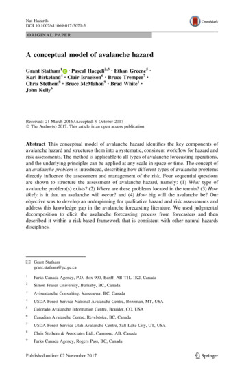
Nat Hazardsavalanche forecasters assess spatial scale in ways that refer directly to the spatial extent ofthe terrain they are analyzing (Table 2).Avalanche forecasting accuracy also depends on temporal scale, with predictions havingincreasing uncertainty farther into the future. Because fluctuations in avalanche hazard aredependent upon weather, the quality of weather and climate predictions strongly affects thequality of avalanche hazard forecasts. In general, the shorter the time span, the moreaccurate the forecast. Table 3 shows the common time spans that avalanche forecasters andplanners work under.Scale has a dominant influence on the scope of an avalanche hazard assessment. Theextent of an assessment in both space and time determines such fundamental parameters asdata requirements, how much uncertainty is acceptable and estimates of likelihood, toname just a few. A clear awareness of the relevant spatial and temporal scales is imperativefor every avalanche hazard assessment.4.2 Avalanche problem frameworkThe CMAH is organized around the central concept of an avalanche problem (Haegeliet al. 2010; Lazar et al. 2012), which has been defined as a ‘set of factors that describe theavalanche hazard’ (CAA 2013). Figure 1 illustrates the structure of an avalanche problemand shows how these factors combine to create an avalanche hazard. Often, more than oneproblem will exist, and each different problem represents an actual operational concernabout potential avalanches in terms of their type, location, likelihood and size. This concepthas been used informally for years by avalanche forecasters, who often focus on one or twospecific issues for their assessment. Assessing distinct avalanche problems that aredescribed by key factors is similar to the use of scenarios in traditional risk analysis(Jamieson et al. 2010b).The premise of the CMAH is that (1) identifying and assessing different types ofavalanche problems is more relevant than solely assessing the ease of triggering avalancheswhen managing backcountry avalanche risk (Atkins 2004) and (2) integrating avalanchesize with likelihood is a fundamental rule of avalanche hazard assessment (Meister 1994).Previous formal approaches in North America and Europe for assessing backcountryavalanche hazard were focused primarily on avalanche probability and snowpack stabilitySensi vityto TriggersType ofAvalancheProblemLikelihoodofAvalanche(s)Loca onAvalancheHazardSpa alDistribu onDestruc veAvalanche SizeFig. 1 Structure of an avalanche problem. Each problem is defined by its type, location, likelihood and size123
Nat Hazards(Dennis and Moore 1996), with little or no consideration given to different types ofavalanche problems or their potential magnitude. Only recently has avalanche size beenformally incorporated into the Bavarian Matrix (Müller et al. 2016b).When assessing avalanche hazard, forecasters consider four sequential questions:1.2.3.4.What type of avalanche problem(s) exists?Where are these problems located in the terrain?How likely is it that an avalanche will occur?How big will the avalanche be?These questions address the key components of an avalanche problem, and answeringthem constitutes the process of avalanche hazard assessment. While assessments at different operations may use different techniques (e.g., individual judgment, consensusteamwork, software, checklists), the components and their sequence are universal. Forexample, a lone ski guide making decisions in real-time at the top of a slope considers thesame questions as an office-based avalanche forecaster producing a 24-h forecast for abroad geographic region. The following four subsections describe the formal assessment ofthese questions in detail.4.2.1 Type of avalanche problemDifferent snowpack structures create different types of avalanche problems. For example, adry loose avalanche problem presents a completely different pattern of avalanche releasethan a storm slab avalanche problem, despite the fact that they are both formed by anoverload of new snow. Similarly, a wind slab avalanche problem is a fundamentallydifferent type of problem than a persistent slab avalanche problem, notwithstanding theyare both slab avalanches. These different types of avalanche problems are repeatable patterns, formed from a disparate set of snowpack, weather and even terrain factors thatrequire distinct risk management techniques. Recognizing these patterns and distinguishingbetween the different types of avalanche problems is a fundamental tenet of effectiveavalanche risk management, and the first step toward characterizing an avalanche problemin the CMAH.Atkins (2004), who first introduced the concept of avalanche problems in NorthAmerica, separated avalanche activity into 27 different regimes, such as ‘wind slabs nearridge tops’ or ‘small slab avalanches in storm snow,’ and postulated that terrain choiceswere in fact most strongly influenced by these regimes. In Europe, Harvey et al. (2009)suggested four different kinds of ‘avalanche situations,’ or patterns of avalanche characteristics and distribution, mainly based on the meteorological conditions that produce theavalanche situation. Finally, Mair and Nairz (2010) introduced ten avalanche dangerpatterns to highlight conditions that frequently lead to avalanche accidents. Statham et al.(2010b) refined the ideas presented by Atkins (2004) and introduced eight differentAvalanche Characters, which were described in detail by Haegeli et al. (2010) in terms oftheir development, avalanche activity patterns, recognition and assessment in the field, andrisk management strategies. While there are considerable similarities and overlap betweenthe kinds of avalanche problems identified by these different authors, there is a fundamental difference among the perspectives. The descriptions of the European classificationsprimarily focus on the meteorological factors creating the condition, whereas the NorthAmerican perspective is foremost tied to how the different types of avalanche problemsrequire different risk mitigation strategies.123
Nat HazardsThe CMAH builds on the eight Avalanche Characters introduced by Statham et al.(2010b), but calls them types of avalanche problems, as the characterization of avalancheproblems also includes information about their location in the terrain, likelihood and size.The nine different types of avalanche problems included in the CMAH (Table 4) representtypical, repeatable and observable patterns in the formation, persistence, underlying weaklayer, overlying slab, potential fracture propagation and size of the avalanche, along withcommon risk mitigation actions. Although classified as discrete choices, the boundariesbetween the different types of avalanche problems are soft, and problems can transitionfrom one type to another as the snowpack changes over time.Identifying and tracking specific types of avalanche problems is a critically importantpart of the hazard assessment process because it provides an overarching filter (Haegeliet al. 2010) that sets expectations (e.g., typical locations and patterns of avalanche activity)and influences all subsequent choices, including what type of observations are most relevant for the assessment (Jamieson et al. 2010b) and effective approaches for risk management. For example, terrain selection and/or explosive placement differs substantiallybetween a deep persistent slab and a storm slab problem. Often, more than one type ofavalanche problem will exist, in which case they are usually prioritized according to themost dominant type(s). Lazar et al. (2012) provide a decision tree to assist forecasters inprioritizing. The concept of different types of avalanche problems has quickly gained broadacceptance in the professional and recreational avalanche communities in North America.Lazar et al. (2012), Statham et al. (2012) and Klassen et al. (2013) all describe theintroduction of avalanche problems as central to public warnings and risk management.4.2.2 Location in the terrainTerrain influences all weather and snowpack processes, whether broadly at the scale of amountain range, or locally on an individual terrain feature (e.g., Birkeland 2001; Grünewald et al. 2013). Changes in terrain correspond with changes in snowpack structure, andthe resulting spatial variability is a major source of uncertainty in avalanche forecasting(Haegeli and McClung 2004). Static terrain factors such as slope angle, shape, aspect andelevation directly influence both in situ snowpack development, and the impact of weatherfactors such as precipitation, air temperature and wind. Terrain is the constant modifier onall factors that influence avalanche formation (Schweizer et al. 2008), and understandingwhere a particular avalanche problem is located in the terrain is crucial for effectivelymanaging the associated risk. For backcountry travel, the exposure component of risk(people’s time and position in terrain) is the single most important consideration forcontrolling risk (Statham 2008). Accordingly, avalanche forecasters must possess an indepth understanding of the interaction between terrain and snowpack processes. Schweizeret al. (2008) desc
A conceptual model of avalanche hazard Grant Statham1 Pascal Haegeli2,3 Ethan Greene5 Karl Birkeland4 Clair Israelson6 Bruce Tremper7 Chris Stethem8 Bruce McMahon9 Brad White1 John Kelly6 Received: 21 March 2016/Accepted: 9 October 2017 The Author(s) 2017. This article is an open access publication