Transcription
HIWASSEE RIVER WATERSHED (06020002)OF THE TENNESSEE RIVER BASINWATERSHED WATER QUALITYMANAGEMENT PLANTENNESSEE DEPARTMENT OF ENVIRONMENT AND CONSERVATIONDIVISION OF WATER POLLUTION CONTROLWATERSHED MANAGEMENT SECTION2003
GlossaryGLOSSARY1Q20. The lowest average 1 consecutive days flow with average recurrence frequencyof once every 20 years.30Q2. The lowest average 3 consecutive days flow with average recurrence frequencyof once every 2 years.7Q10. The lowest average 7 consecutive days flow with average recurrence frequencyof once every 10 years.303(d). The section of the federal Clean Water Act that requires a listing by states,territories, and authorized tribes of impaired waters, which do not meet the water qualitystandards that states, territories, and authorized tribes have set for them, even afterpoint sources of pollution have installed the minimum required levels of pollution controltechnology.305(b). The section of the federal Clean Water Act that requires EPA to assemble andsubmit a report to Congress on the condition of all water bodies across the Country asdetermined by a biennial collection of data and other information by States and Tribes.AFO. Animal Feeding Operation.Ambient Sites. Those sites established for long term instream monitoring of waterquality.ARAP. Aquatic Resource Alteration Permit.Assessment. The result of an analysis of how well streams meet the water qualitycriteria assigned to them.Bankfull Discharge. The momentary maximum peak flow before a stream overflows itsbanks onto a floodplain.Basin. An area that drains several smaller watersheds to a common point. Mostwatersheds in Tennessee are part of the Cumberland, Mississippi, or Tennessee Basin(The Conasauga River and Barren River Watersheds are the exceptions).Benthic. Bottom dwelling.Biorecon. A qualitative multihabitat assessment of benthic macroinvertebrates thatallows rapid screening of a large number of sites. A Biorecon is one tool used torecognize stream impairment as judged by species richness measures, emphasizing thepresence or absence of indicator organisms without regard to relative abundance.BMP. An engineered structure or management activity, or combination of these, thateliminates or reduces an adverse environmental effect of a pollutant.1
GlossaryBOD. Biochemical Oxygen Demand. A measure of the amount of oxygen consumed inthe biological processes that break down organic and inorganic matter.CAFO. Concentrated Animal Feeding Operation.Designated Uses. The part of Water Quality Standards that describes the uses ofsurface waters assigned by the Water Quality Control Board. All streams in Tennesseeare designated for Recreation, Fish and Aquatic Life, Irrigation, and Livestock Wateringand Wildlife. Additional designated uses for some, but not all, waters are Drinking WaterSupply, Industrial Water Supply, and Navigation.DMR. Discharge Monitoring Report. A report that must be submitted periodically to theDivision of Water Pollution Control by NPDES permitees.DO. Dissolved oxygen.EPA. Environmental Protection Agency. The EPA Region 4 web site ishttp://www.epa.gov/region4/Field Parameter. Determinations of water quality measurements and values made inthe field using a kit or probe. Common field parameters include pH, DO, temperature,conductivity, and flow.Fluvial Geomorphology. The physical characteristics of moving water and adjoininglandforms, and the processes by which each affects the other.HUC-8. The 8-digit Hydrologic Unit Code corresponding to one of 54 watersheds inTennessee.HUC-10. The 10-digit NRCS Hydrologic Unit Code. HUC-10 corresponds to a smallerland area than HUC-8.HUC-12. The 12-digit NRCS Hydrologic Unit Code. HUC-12 corresponds to a smallerland area than HUC-10.MRLC. Multi-Resolution Land Classification.MS4. Municipal Separate Storm Sewer System.Nonpoint Source (NPS). Sources of water pollution without a single point of origin.Nonpoint sources of pollution are generally associated with surface runoff, which maycarry sediment, chemicals, nutrients, pathogens, and toxic materials into receivingwaterbodies. Section 319 of the Clean Water Act of 1987 requires all states to assessthe impact of nonpoint source pollution on the waters of the state and to develop aprogram to abate this impact.NPDES. National Pollutant Discharge Elimination System. Section 402 of the CleanWater Act of 1987 requires dischargers to waters of the U.S. to obtain NPDES permits.NRCS. Natural Resources Conservation Service. NRCS is part of the federalDepartment of Agriculture. The NRCS home page is http://www.nrcs.usda.gov2
GlossaryPoint Source. Any discernable, confined, and discrete conveyance, including but notlimited to any pipe, ditch, channel, tunnel, conduit, well, discrete fissure, container,rolling stock, concentrated animal feeding operation, or vessel or other floating craft,from which pollutants are or may be discharged. This term does not include agriculturalstorm water discharges and return flows from irrigated agriculture (Clean Water ActSection 502(14)).Q Design. The average daily flow that a treatment plant or other facility is designed toaccommodate.Reference Stream (Reference Site). A stream (site) judged to be least impacted. Datafrom reference streams are used for comparisons with similar streams.SBR. Sequential Batch Reactor.Stakeholder. Any person or organization affected by the water quality or by anywatershed management activity within a watershed.STATSGO. State Soil Geographic Database. STATSGO is compiled and maintained bythe Natural Resources Conservation Service.STORET. The EPA repository for water quality data that is used by state environmentalagencies, EPA and other federal agencies, universities, and private citizens. STORET(Storage and Retrieval of National Water Quality Data System) data can be accessed athttp://www.epa.gov/storet/TDA. Tennessee culture.TheTDAwebaddressisTDEC. Tennessee Department of Environment and Conservation. The TDEC webaddress is http://www.tdec.netTMDL. Total Maximum Daily Load. A TMDL is a calculation of the maximum amount of apollutant that a waterbody can receive and still meet water quality standards, and anallocation of the amount to the pollutant’s sources. A TMDL is the sum of the allowableloads of a single pollutant from all contributing point and nonpoint sources. Thecalculation includes a margin of safety to ensure that the waterbody can be used for thepurposes the State has designated. The calculation must also account for seasonalvariation in water quality. A TMDL is required for each pollutant in an impaired stream asdescribed in Section 303 of the Federal Clean Water Act of 1987. Updates andinformation on Tennessee’s TMDLs can be found at http://www.tdec.net/wpc/tmdl/TMSP. Tennessee Multi-Sector Permit.USGS. United States Geological Survey. USGS is part of the federal Department of theInterior. The USGS home page is http://www.usgs.gov/.WAS. Waste Activated Sludge.3
GlossaryWater Quality Standards. A triad of designated uses, water quality criteria, andantidegradation statement. Water Quality Standards are established by Tennessee andapproved by EPA.Watershed. A geographic area which drains to a common outlet, such as a point on alarger stream, lake, underlying aquifer, estuary, wetland, or ocean.WET. Whole Effluent Toxicity.WWTP. Waste Water Treatment Plant4
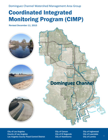
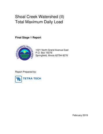
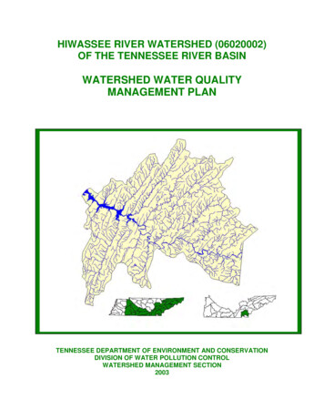
Summary – Hiwassee RiverIn 1996, the Tennessee Department of Environmentand Conservation Division of Water PollutionControl adopted a watershed approach to waterquality. This approach is based on the idea thatmany water quality problems, like the accumulationof point and nonpoint pollutants, are best addressedat the watershed level. Focusing on the wholewatershed helps reach the best balance amongefforts to control point sources of pollution andpolluted runoff as well as protect drinking watersources and sensitive natural resources such aswetlands. Tennessee has chosen to use the USGS 8digit Hydrologic Unit Code (HUC-8) as theorganizing unit.The Watershed Approach recognizes awareness thatrestoring and maintaining our waters requirescrossing traditional barriers (point vs. nonpointsources of pollution) when designing solutions.These solutions increasingly rely on participation byboth public and private sectors, where citizens,elected officials, and technical personnel all haveopportunities to participate. The WatershedApproach provides the framework for a watershedbased and community-based approach to addresswater quality problems.Chapter 1 of the Hiwassee River Watershed WaterQuality Management Plan discusses the WatershedApproach and emphasizes that the WatershedApproach is not a regulatory program or an EPAmandate; rather it is a decision-making process thatreflects a common strategy for informationcollection and analysis as well as a commonunderstanding of the roles, priorities, andresponsibilities of all stakeholders within awatershed. Traditional activities like permitting,planning and monitoring are also coordinated in theWatershed Approach.A detailed description of the watershed can befound in Chapter 2. The Tennessee Portion of theHiwassee River Watershed is approximately 1,011square miles and includes parts of six Tennesseecounties. A part of the Tennessee River drainagebasin, the watershed has 1,657 stream miles.Transitional0.8%Row Crops4.6%Pasture/Hay18.5%Woody Wetlands0.6%Quarries0.0%Deciduous Forest31.0%Other Grasses0.6%EmergentHerbaceousWetlands0.2%Open Water0.9%Mixed Forest21.2%Low Intensity(Residential)1.4%High Intensity(Residential)0.3%Evergreen Forest19.3%High Intensity(Commercial)0.7%Land Use in the Tennessee portion of the Hiwassee RiverWatershed is based on MRLC Satellite Imagery.One Greenway, four interpretive areas, and eightwildlife management areas are located in thewatershed. Sixty-two rare plant and animal specieshave been documented in the watershed, includingfour rare fish species and three rare mussel species.Portions of two streams in the Tennessee portion ofthe Hiwassee River Watershed are listed in theNational Rivers Inventory as having one or moreoutstanding natural or cultural values.A review of water quality sampling and assessmentis presented in Chapter 3. Using the WatershedApproach to Water Quality, 34 sampling sites wereutilized in the Hiwassee River Watershed. Thesewere ambient, ecoregion, special survey orwatershed monitoring sites. Monitoring resultssupport the conclusion that 38% of total streammiles (based on RF3) fully support designated uses.NOT YSUPPORTS15%Water Quality Assessment in theTennessee portion of theHiwassee River Watershed is Based on the 1998 303(d) List.
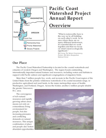
Also in Chapter 3, a series of maps illustrate OverallUse Support in the watershed, as well as UseSupport for the individual uses of Fish and AquaticLife Support, Recreation, Irrigation, and LivestockWatering and Wildlife. Another series of mapsillustrate streams that are listed for impairment byspecific causes (pollutants) such as Pathogens,Habitat Alteration and Siltation.Point and Nonpoint Sources are addressed inChapter 4, which is organized by HUC-10subwatersheds. Maps illustrating the locations ofSTORET monitoring sites and USGS streamgauging stations are presented in eachsubwatershed.partnerships between agencies and betweenagencies and landowners that are essential tosuccess. Programs of federal agencies (NaturalResources Conservation Service, U.S. Fish andWildlife Service, U.S. Geological Survey,Tennessee Valley Authority, U.S.D.A. ForestService), and state agencies (TDEC Division ofCommunity Assistance, TDEC Division of WaterSupply, Tennessee Department of Agriculture,North Carolina Department of Environment andNatural Resources) are summarized. Localinitiatives of active watershed organizations(Hiwassee River Watershed Coalition) are alsodescribed.Point and Nonpoint source approaches to waterquality problems in the Hiwassee River Watershedare addressed in Chapter 6. Chapter 6 also includescomments received during public meetings, alongwith an assessment of needs for the watershed.The full Hiwassee River Watershed Water .tn.us/environment/wpc/watershed/wsmplans/.HUC-10 Subwatersheds in the Tennessee portion of theHiwassee River Watershed.Point source contributions to the Hiwassee RiverWatershed consist of 14 individual NPDESpermitted facilities, seven of which discharge intostreams that have been listed on the 1998 303(d)list. Other point source permits in the watershed areAquatic Resource Alteration Permits (15),Tennessee Multi-Sector Permits (78), MiningPermits (6), and Water Treatment Plant Permits (1).Agricultural operations include cattle, chicken, hog,and sheep farming. Maps illustrating the locationsof NPDES and ARAP permit sites are presented ineach subwatershed.Chapter 5 is entitled Water Quality Partnerships inthe Hiwassee River Watershed and highlights
Chapter 1CHAPTER 1WATERSHED APPROACH TO WATER QUALITY1.1Background1.2Watershed Approach to Water Quality1.2.A. Components of the Watershed Approach1.2.B. Benefits of the Watershed Approach1.1 BACKGROUND. The Division of Water Pollution Control is responsible foradministration of the Tennessee Water Quality Control Act of 1977 (TCA 69 3 101).Information about the Division of Water Pollution Control, updates and announcements,may be found at http://www.state.tn.us/environment/wpc/index.html, and a summary ofthe organization of the Division of Water Pollution Control may be found in Appendix I.The mission of the Division of Water Pollution Control is to abate existing pollution of thewaters of Tennessee, to reclaim polluted waters, to prevent the future pollution of thewaters, and to plan for the future use of the waters so that the water resources ofTennessee might be used and enjoyed to the fullest extent consistent with themaintenance of unpolluted waters.The Division monitors, analyzes, and reports on the quality of Tennessee's water. Inorder to perform these tasks more effectively, the Division adopted a WatershedApproach to Water Quality in 1996.This Chapter summarizes TDEC's Watershed Approach to Water Quality.1.2 WATERSHED APPROACH TO WATER QUALITY. The Watershed Approach toWater Quality is a coordinating framework designed to protect and restore aquaticsystems and protect human health more effectively (EPA841-R-95-003). The Approachis based on the concept that many water quality problems, like the accumulation ofpollutants or nonpoint source pollution, are best addressed at the watershed level. Inaddition, a watershed focus helps identify the most cost-effective pollution controlstrategies to meet clean water goals. Tennessee’s Watershed Approach, updates 1.htm.1
Chapter 1Watersheds are appropriate as organizational units because they are readily identifiablelandscape units with readily identifiable boundaries that integrate terrestrial, aquatic, andgeologic processes. Focusing on the whole watershed helps reach the best balanceamong efforts to control point source pollution and polluted runoff as well as protectdrinking water sources and sensitive natural resources such as wetlands (EPA-840-R98-001).Four main features are typical of the Watershed Approach: 1) Identifying and prioritizingwater quality problems in the watershed, 2) Developing increased public involvement, 3)Coordinating activities with other agencies, and 4) Measuring success through increasedand more efficient monitoring and other data gathering.Typically, the Watershed Approach meets the following description (EPA841-R-95-003): Features watersheds or basins as the basic management unitsTargets priority subwatersheds for management actionAddresses all significant point and nonpoint sources of pollutionAddresses all significant pollutantsSets clear and achievable goalsInvolves the local citizenry in all stages of the programUses the resources and expertise of multiple agenciesIs not limited by any single agency’s responsibilitiesConsiders public health issuesAn additional characteristic of the Watershed Approach is that it complements otherenvironmental activities. This allows for close cooperation with other state agencies andlocal governments as well as with federal agencies such as the Tennessee ValleyAuthority and the U.S. Army Corps of Engineers, U.S. Department of Agriculture (e.g.,Natural Resources Conservation Service, United States Forest Service), U.S.Department of the Interior (e.g. United States Geological Survey, U.S. Fish and WildlifeService, National Park Service). When all permitted dischargers are consideredtogether, agencies are better able to focus on those controls necessary to producemeasurable improvements in water quality. This also results in a more efficient process:It encourages agencies to focus staff and financial resources on prioritized geographiclocations and makes it easier to coordinate between agencies and individuals with aninterest in solving water quality problems (EPA841-R-003).The Watershed Approach is not a regulatory program or a new EPA mandate; rather it isa decision making process that reflects a common strategy for information collection andanalysis as well as a common understanding of the roles, priorities, and responsibilitiesof all stakeholders within a watershed. The Watershed Approach utilizes featuresalready in state and federal law, including: Water Quality StandardsNational Pollutant Discharge Elimination System (NPDES)Total Maximum Daily Loads (TMDLs)Clean Lakes ProgramNonpoint Source ProgramGroundwater Protection2
Chapter 1Traditional activities like permitting, planning, and monitoring are also coordinated in theWatershed Approach. A significant change from the past, however, is that theWatershed Approach encourages integration of traditional regulatory (point sourcepollution) and nonregulatory (nonpoint sources of pollution) programs. There areadditional changes from the past as well:THE PASTWATERSHED APPROACHFocus on fixed-station ambient monitoringFocus on comprehensive watershed monitoringFocus on pollutant discharge sitesFocus on watershed-wide effectsFocus on WPC programsFocus on coordination and cooperationFocus on point sources of pollutionFocus on all sources of pollutionFocus on dischargers as the problemFocus on dischargers as an integral part of the solutionFocus on short-term problemsFocus on long-term solutionsTable 1-1. Contrast Between the Watershed Approach and the Past.This approach places greater emphasis on all aspects of water quality, includingchemical water quality (conventional pollutants, toxic pollutants), physical water quality(temperature, flow), habitat quality (channel morphology, composition and health ofbenthic communities), and biodiversity (species abundance, species richness).1.2.A. Components of the Watershed Approach. Tennessee is composed of fifty-fivewatersheds corresponding to the 8-digit USGS Hydrologic Unit Codes (HUC-8). Thesewatersheds, which serve as geographic management units, are combined in five groupsaccording to year of implementation.Figure 1-1. Watershed Groups in Tennessee’s Watershed Approach to Water Quality.3
Chapter 1Each year, TDEC conducts monitoring in one-fifth of Tennessee’s watersheds;assessment, priority setting and follow-up monitoring are conducted in another one fifthof watersheds; modeling and TMDL studies in another one fifth; developingmanagement plans in another one fifth; and implementing management plans in anotherone fifth of NNESSEE1NonconnahSouth Fork Forked DeerHarpethStonesConasaugaEmoryOcoeeWataugaWatts Bar2LoosahatchieMiddle Fork Forked DeerNorth Fork Forked DeerCaney ForkCollinsLower ElkPickwick LakeUpper ElkWheeler LakeFort LoudounHiwasseeSouth Fork Holston (Upper)Wheeler Lake3Tennessee Western Valley (Beech River)Tennessee Western Valley (KY Lake)Wolf RiverBuffaloLower DuckUpper DuckLittle TennesseeLower ClinchNorth Fork HolstonSouth Fork Holston (Lower)Tennessee (Upper)4Lower HatchieUpper HatchieBarrenObeyRedUpper Cumberland(Cordell Hull Lake)Upper Cumberland(Old Hickory Lake)Upper Cumberland(Cumberland Lake)HolstonPowellSouth Fork CumberlandTennessee (Lower)Upper ClinchUpper Cumberland(Clear Fork)5MississippiNorth Fork ObionSouth Fork ObionGuntersville LakeLower Cumberland(Cheatham Lake)Lower Cumberland(Lake Barkley)Lower French BroadNolichuckyPigeonUpper French BroadTable 1-2. Watershed Groups in Tennessee’s Watershed Approach.4
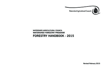
Chapter 1In succeeding years of the cycle, efforts rotate among the watershed groups. Theactivities in the five year cycle provide a reference for all stakeholders.Figure 1-2. The Watershed Approach Cycle.5
Chapter 1The six key activities that take place during the cycle are:1. Planning and Existing Data Review. Existing data and reports fromappropriate agencies and organizations are compiled and used to describethe current conditions and status of rivers and streams. Reviewing all existingdata and comparing agencies’ work plans guide the development of aneffective monitoring strategy.2. Monitoring. Field data is collected for streams in the watershed. These datasupplement existing data and are used for the water quality assessment.3. Assessment. Monitoring data are used to determine the status of the stream’sdesignated use supports.4. Wasteload Allocation/TMDL Development. Monitoring data are used todetermine nonpoint source contributions and pollutant loads for permitteddischargers releasing wastewater to the watershed. Limits are set to assurethat water quality is protected.5. Permits. Issuance and expiration of all discharge permits aresynchronized based on watersheds. Currently, 1700 permits havebeen issued in Tennessee under the federally delegated National PollutantDischarge Elimination System (NPDES).6. Watershed Management Plans. These plans include information for eachwatershed including general watershed description, water quality goals, majorwater quality concerns and issues, and management strategies.Public participation opportunities occur throughout the entire five year cycle.Participation in Years 1, 3 and 5 is emphasized, although additional meetings are held atstakeholder’s request. People tend to participate more readily and actively in protectingthe quality of waters in areas where they live and work, and have some roles andresponsibilities: Data sharingIdentification of water quality stressorsParticipation in public meetingsCommenting on management plansShared commitment for plan implementation6
Chapter 11.2.B. Benefits of the Watershed Approach. The Watershed Approach fosters a betterunderstanding of the physical, chemical and biological effects on a watershed, therebyallowing agencies and citizens to focus on those solutions most likely to be effective.The Approach recognizes the need for a comprehensive, ecosystem-based approachthat depends on local governments and local citizens for success (EPA841-R-95-004).On a larger scale, many lessons integrating public participation with aquatic ecosystembased programs have been learned in the successful Chesapeake Bay, Great Lakes,Clean Lakes, and National Estuary Programs.Benefits of the Watershed Approach include (EPA841-R-95-004): Focus on water quality goals and ecological integrity rather than on programactivities such as number of permits issued. Improve basis for management decisions through consideration of both pointand nonpoint source stressors. A watershed strategy improves the scientificbasis for decision making and focuses management efforts on basins andwatersheds where they are most needed. Both point and nonpoint controlstrategies are more effective under a watershed approach because theApproach promotes timely and focused development of TMDLs. Enhance program efficiency, as the focus becomes watershed. A watershedfocus can improve the efficiency of water management programs byfacilitating consolidation of programs within each watershed. For example,handling all point source dischargers in a watershed at the same timereduces administrative costs due to the potential to combine hearings andnotices as well as allowing staff to focus on more limited areas in a sequentialfashion. Improve coordination between federal, state and local agencies includingdata sharing and pooling of resources. As the focus shifts to watersheds,agencies are better able to participate in data sharing and coordinatedassessment and control strategies. Increase public involvement. The Watershed Approach provides opportunitiesfor stakeholders to increase their awareness of water-related issues andinform staff about their knowledge of the watershed. Participation is via threepublic meetings over the five-year watershed management cycle as well asmeetings at stakeholder’s request. Additional opportunities are providedthrough the Department of Environment and Conservation homepage anddirect contact with local Environmental Assistance Centers. Greater consistency and responsiveness. Developing goals and managementplans for a basin or watershed with stakeholder involvement results inincreased responsiveness to the public and consistency in determiningmanagement actions. In return, stakeholders can expect improvedconsistency and continuity in decisions when management actions follow awatershed plan.7
Chapter 1Additional benefits of working at the watershed level are described in the Clean http://www.cleanwater.gov/action/toc.html.The Watershed Approach represents awareness that restoring and maintaining ourwaters requires crossing traditional barriers (point vs. nonpoint sources of pollution)when designing solutions. These solutions increasingly rely on participation by bothpublic and private sectors, where citizens, elected officials and technical personnel allhave opportunity to participate. This integrated approach mirrors the complicatedrelationships in which people live, work and recreate in the watershed, and suggests acomprehensive, watershed-based and community-based approach is needed to addressthese (EPA841-R-97-005).8
Hiwassee River Watershed-Chapter 2Revised 2003DRAFTCHAPTER 2DESCRIPTION OF THE HIWASSEE RIVER WATERSHED2.1.Background2.2.Description of the Watershed2.2.A. General Location2.2.B. Population Density Centers2.3.General Hydrologic Description2.3.A. Hydrology2.3.B. Dams2.4.Land Use2.5.Ecoregions and Reference Streams2.6.Natural Resources2.6.A. Rare Plants and Animals2.6.B. Wetlands2.7.Cultural Resources2.7.A. State Scenic River2.7.B. Nationwide Rivers Inventory2.7.C. Greenways2.7.D. Interpretive Areas2.7.E. Wildlife Management Area2.8.Tennessee Rivers Assessment Project2.1. BACKGROUND. The name “Hiwassee” is taken from the Cherokee word “AyeHawsasi”, which means “meadow along the stream.” The area is characterized byforested slopes, high gradient, clear streams, and rugged terrain. There is great aquatichabitat diversity in the watershed.Part of the Hiwassee River is included in the State Scenic River System due to its scenicand pastoral nature. The Hiwassee was the first river managed in the State ScenicRiver Program. The many river outfitters along the Hiwassee River indicate itspopularity among recreational boaters. Hunting and fishing are popular in the CherokeeNational Forest.This Chapter describes the location and characteristics of the Hiwassee RiverWatershed.1
Hiwassee River Watershed-Chapter 2Revised 2003DRAFT2.2. DESCRIPTION OF THE WATERSHED.2.2.A. General Location. The Hiwassee River Watershed is located in East Tennesseeand North Carolina. The Tennessee portion includes parts of Bradley, Hamilton,McMinn, Meigs, Monroe, and Polk Counties.Figure 2-1. General Location of the Hiwassee River Watershed.COUNTY% OF WATERSHED IN EACH oe12.3Polk19.0Table 2-1. The Hiwassee River Watershed Includes Parts of Six East Tennessee Counties.2
Hiwassee River Watershed-Chapter 2Revised 2003DRAFT2.2.B. Population Density Centers. Eight state highways and two interstates serve themajor communities in the Hiwassee River Watershed.Figure 2-2. Municipalities and Roads in the Tennessee Portion of the Hiwassee radleyCalhoun575McMinnTable 2-2. Municipalities in the Tennessee Portion of the Hiwassee River Watershed.Population based on 1996 census (Tennessee Blue Book). Asterisk (*) indicates county seat.2.3. GENERAL HYDROLOGIC DESCRIPTION.3
Hiwassee River Watershed-Chapter 2Revised 2003DRAFT2.3.A. Hydrology. The Hiwassee River Watershed, designated 06020002 by the USGS,drains approximately 2,099 square miles, 1,011 square miles of which are in Tennessee,and empties to Chickamauga Reservoir (Tennessee River).Figure 2-3. The Hiwassee River Watershed is Part of the Tennessee River Basin.4
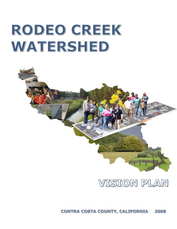
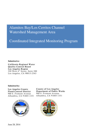
Hiwassee River Watershed-Chapter 2Revised 2003DRAFTFigure 2-4. Hydrology in the Tennessee Portion of the Hiwassee River Watershed. Thereare 3,113 total stream miles recorded in River Reach File 3 in the Hiwassee River Watershed.1,657 stream miles are recorded in Tennessee. Location of the Hiwassee River, ChickamaugaLake, and the cities of Cleveland, Etowah, and Niota are shown for reference.5
Hiwassee River Watershed-Chapter 2Revised 2003DRAFT2.3.B. Dams. There are 24 dams inventoried by TDEC Division of Water Supply in theHiwassee River Watershed. These dams either retain 30 acre-feet of water or havestructures at least 20 feet high.Figure 2-5. Location of Inventoried Dams in the Tennessee Portion of the Hiwassee RiverWatershed. More information is provided in Hiwassee-Appendix II and on the TDEC homepageat http://gw
Watershed Approach. A detailed description of the watershed can be found in Chapter 2. The Tennessee Portion of the Hiwassee River Watershed is approximately 1,011 square miles and includes parts of six Tennessee counties. A part of the Tennessee River drainage basin, the watershed has 1,657 stream miles. Evergreen Forest 19.3% Emergent Herbaceous