Transcription
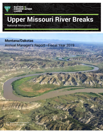
Upper Missouri River BreaksNational‘ MonumentMontana/DakotasAnnual Manager’s Report—Fiscal Year 2019U.S. Department of the InteriorBureau of Land Management
Table of ContentsUpper Missouri River Breaks Fact Sheet . 2Unit Map . 4Upper Missouri River Breaks Overview . 5Programs and Accomplishments . 11Science . 24Resources, Objects, Values, and Stressors . 27Summary of Performance Measure . 46Manager’s Letter . 48
Upper Missouri River BreaksNational MonumentDesignating AuthorityDesignating Authority:Date of Designation:Presidential Proclamation #7398January 17, 2001Additional DesignationsUpper Missouri National Wild & Scenic RiverLewis & Clark National Historic TrailNez Perce (Nee-Me-Poo) National Historic TrailSite DescriptionThe Upper Missouri River Breaks National Monument (Monument/UMRBNM) containsa spectacular array of biological, geological, and historical objects of interest. Locatedin central Montana between Fort Benton, the nation’s inmost port, east to the CharlesM. Russell National Wildlife Refuge, the Monument spans 149 miles of the UpperMissouri River, over 377,000 acres of the adjacent Breaks country, and portions ofArrow Creek, Cow Creek, and the Judith River. The landscape has remained largelyunchanged since Meriwether Lewis and William Clark traveled through it on their epicjourney with the Corps of Discovery over 200 years ago.Monument OfferingsUpper Missouri National Wild & Scenic River (149 river miles, 135,350 acres)Lewis & Clark National Historic Trail (149 miles)Nez Perce (Nee-Me-Poo) National Historic Trail (15 miles)Cow Creek Wilderness Study Area (34,050 acres)Antelope Creek Wilderness Study Area (12,350 acres)Woodhawk Wilderness Study Area (8,100 acres)Ervin Ridge Wilderness Study Area (10,200 acres)Stafford Wilderness Study Area (4,800 acres)Dog Creek South Wilderness Study Area (5,150 acres)Missouri Breaks Back Country Byway (27 miles)Judith Landing Historic DistrictNelson Homestead Historic DistrictFrancis Hagadone Homestead Historic DistrictGist Bottom/Ervin Homestead Historic District
Richard E. Wood Watchable Wildlife AreaWood River Ranch Sikes Act Management AreaJames Kipp Campground and boat launchCoal Banks Campground and boat launchJudith Landing Campground and boat launchMissouri Breaks Interpretive Center, Fort BentonYear AccomplishmentsWe responded to the ice damage and flooding, restoring services at all of ourcampgrounds and recreation sites along the eighty miles of impacted wild and scenicriver. We initiated planning for major engineering projects, including two primarystream crossings, along with new warehouse construction. We also signed the BearsPaw to Missouri Breaks Environmental Assessment, renewing ten-year permits on 103grazing allotments for the north half of the Monument and the Havre Field Office. TheMonument itself has 119 allotments and about 38,000 AUMs.Future Priorities and OpportunitiesBy 2020 we intend to complete construction of a warehouse within the Fort BentonNational Historic Landmark, replacing a house that previously had served as a contactstation and storage building. Our contract to update the interpretive space within theInterpretive Center is slated for completion in 2020; this is our first major upgrade toour exhibit hall in over a decade. Filling our four vacant positions is also a priority inFY2020. Maintaining roads and improving access will be emphasized over the nextthree years. We also are working to complete large planning efforts geared atrangeland allotment management, and staff and potential partners will be developingprotocols for more systematic wilderness study area monitoring. We look forward tocompleting a ten-year review of our resource management plan, examining whatchanges have occurred since we signed the record of decision, and holding ourselvesaccountable for how we said we would be managing this landscape.Upper Missouri River BreaksNational Monument920 NE Main StreetLewistown, MT 59457Phone: 406-538-1900Unit Manager: Zane FulbrightSite Web Address: lands/montana-dakotas/upper-missouri-river-breaks
Map of Upper Missouri River Breaks National Monument
1Upper Missouri River Breaks OverviewAcreageTotal Acres in UnitBLM AcresOther Federal AcresState Acres*Private Acres*377,346377,346039,00080,000*State and Private Acres are not part of the total unit acresBudgetBudget TitleCodeFundingRangeland Management1020207,500Cultural Resources Management105060,000Aquatic Habitat Management116038,000Wildlife Habitat Management117016,000Wilderness Management121017,000Recreation & Visitor ServicesAbandoned Mine Lands & HazardousMaterials ManagementDeferred Maintenance & CapitalImprovementsMonuments & Conservation inistrative Support18201,590Total Budget 1,230,710The budget spreadsheet captures dollars allocated to complete projects, operate andmaintain the Interpretive Center, fund seasonal staff, and award contracts. Theallocation does reflect deferred maintenance projects, including two majortransportation design projects as well as design and build funding for the Monumentwarehouse and Interpretive Center exhibit upgrades. The spreadsheet does notcapture the work month spread for the Monument staff.The following table displays the work months allocated to the Monument staffidentified on the Table of Organization. There are several factors not addressed in thetable including: Staff supporting Monument programs who work for a different field office Positions that remain vacant5
Seasonal labor providing support during staffing shortagesBudget TitleCodeWork MonthsRangeland Management10201Riparian Management10404Cultural Resources Management10501Soil, Water, Air Management11608Wildlife Management11703Wilderness Management12101Recreation & Visitor Services122023Recreation Enhancement Fee Program12322Oil & Gas Management13101Resource Management Planning16102MLR Annual & Operational Maintenance16601Monuments & Conservation Areas*171143Total Work Months90*Staff in the North Central Montana District, outside of the Monument, were funded with 39 1711 Work Months in FY19.Current Areas of FocusThis past year the Monument’s agreements with the River & Plains Society and theFriends of the Missouri Breaks Monument expired. While we still have existing MOU’swith both non-government organizations (NGO’s), the inability to partner with theorganizations fiscally limited some of the work we have done in the past. We receivedfunding in FY19 to fund new agreements and resume work on past year projects(riparian habitat restoration, visitor services at the Interpretive Center, recreation sitemaintenance). We did not draft new agreements; however, we did receive fundingagain in FY2020 to finalize those efforts.Planning and NEPAThe Upper Missouri River Breaks National Monument Record of Decision andApproved Resource Management Plan (RMP) was signed in December 2008. In 2013,we completed an evaluation of the RMP. The ten-year evaluation of the plan isscheduled to be completed in FY2020.The BLM North Central Montana District is renewing grazing permits and leases for103 grazing allotments in the Bears Paw to Missouri River Breaks planning area. Thisplanning area contains 103,741 acres of public land mainly located in the southernportion of Phillips, Blaine and Chouteau counties and administered by the UpperMissouri River Breaks National Monument and Havre Field Office. The BLM completedan Environmental Assessment as part of the renewal which focused on ensuring6
Standards of Rangeland Health are being met. The Environmental Assessment wasbased on a comprehensive summary of resource conditions on public land within theplanning area that was finalized in the spring of 2017. We signed this decision inFY2019 and received no protests or appeals.Bears Paw to Missouri Breaks Planning AreaThe District has also been working on the Judith to Judith Planning Area (J2J)Evaluation Report that involves 117 grazing authorizations covering 111 grazingallotments. Eighty-five allotments are within the Lewistown Field Office (LFO) and 24are within the Monument. The total planning area covers 1,252,251 acres; the BLMportion covers 167,381 acres, or 13.4% of the planning area. The J2J planning area isbordered by Arrow Creek on the west, the eastern Fergus county boundary on the east,the Big Snowy Mountains to the south, and the Missouri River to the north. The Judithto Judith Evaluation Report (ER) summarizing the results of the assessments is dueJanuary 2020. The ER document will report the land health of the public landsadministered by the Bureau of Land Management in the Judith Mountains to JudithRiver Planning Area (J2J). This is the first in a series of documents: the EvaluationReport (ER), the Authorized Officer’s Determination of Standards, and the appropriateNational Environmental Policy Act (NEPA) document(s) and subsequent Decision(s).7
Judith to Judith Planning AreaStaffingThe Upper Missouri River Breaks National Monument has a dedicated staff, as well asstaff with shared responsibilities between the Monument and the Havre Field Office(HFO) and the Lewistown Field Office (LFO). Staff is based in Havre, Lewistown, andFort Benton. The hydrologist is in Lewistown and as of October 1, 2019, is supervisedby the Monument Manager. Engineering support comes from Engineers located in theHFO and LFO. The Archeologist located in the HFO and Realty Specialist in the LFOprovide support to the Monument. North Central Montana District (NCMD) SupportServices staff provide administrative support. NCMD Fire crews located in Zortmanand Lewistown provide fire suppression and fuels support.8
In addition to the permanent staff, the invasive species program generally hires threeseasonal employees, the Recreation program generally hires six seasonal employees,and the range program hires two seasonals that are shared with HFO and LFO.Seasonal volunteer campground hosts staff Coal Banks, Judith Landing, and KippRecreation Area.The following table shows the positions with responsibility in the Monument. Thosehighlighted in light orange are those positions currently vacant. The wildlife biologistretired at the end of 2018, the Park Ranger took a new position at the end of 2018, andthe Rangeland Management Specialist has been in a long-term detail since 2017. Theother four positions were vacant through FY2018. Those positions with sharedresponsibility in the Havre Field Office (HFO), the Lewistown Field Office (LFO), and theNorth Central Montana District (NCMD) are identified.The Manager position, vacant in FY18, was filled effective March 17, 2019. TheWildlife Biologist position has been vacant all calendar year 2019. It will be filled inFebruary 2020. The Outdoor Recreation Planner position was on staff through FY19,but the position became vacant in December 2019.9
Monument Manager GS-0340-12UMRBNM100Table ofOrganizationMonumentLaw Enforcement Ranger BNM/HFO75UMRBNM100Position TitleHydrologist GS-1315-11Natural Resource Specialist (Weeds) GS0401-11Wildlife Biologist GS-0486-11 (Vacant)*Rangeland Management Specialist GS0454-11 (Vacant)Rangeland Management Specialist GS0454-11Area ofResponsibilityUMRBNM/HFOUMRBNM/LFO% working in theMonument7575MonumentHavreLewistownMonumentRange Technician GS-0455-7 (CS) (Vacant)Outdoor Recreation Planner GS-0023-11(Vacant as of 12/2019)UMRBNMUMRBNM100Park Ranger GS-0025-9UMRBNM100MonumentPark Ranger (Interpretation) GS-0025-9Information Receptionist GS-0304-4 (CS)(Vacant)Maintenance Worker WG-4749-8 ument100MonumentMonumentMonumentAdministrative Support AssistantNCMD10DistrictFinancial TechnicianNCMD20DistrictPlanning & Environmental alty SpecialistNatural Resource Specialist (Oil/GasRealty)UMRBNM/LFO50LewistownNCMD20Legal Instruments ExaminerUMRBNM/LFO20LewistownNCMD10DistrictCivil EngineerUMRBNM/HFO50HavreCivil EngineerUMRBNM/LFO50LewistownSafety & Occupational SpecialistHavre10
2Programs and AccomplishmentsGeneral AccomplishmentsThe Monument experienced another year of transition in 2019. Staff turnover affectedthe overall productivity, and we continued to experience changing relationships withour partners. Acting managers maintained relationships with local governments,private landowners, and NGOs, and staff continued their inventory and monitoringwork.Visitation within the Monument remained consistent with past years, whileeducational programming with public schools declined with the lack of permanentstaff. The Interpretive Center closed during the winter due to the loss of ourInterpretive Center Director and administrative staff. While that was unfortunate, ourseason of operation did coincide with the other museums and points of interest in FortBenton.The recreation staff monitored Wilderness Study Areas, the Lewis and Clark NationalHistorical Trail, the Nez Perce National Historical Trail, and the Missouri Breaks BackCountry Byway. They also renewed and issued 26 Special Recreation Permits; thosepermits allowed outfitters to get approximately 700 visitors out on the Upper MissouriNational Wild and Scenic River.We completed proactive cultural resource inventories within the Upper MissouriNational Wild and Scenic River, and Lewis & Clark National Historic Trail corridors,resulting in the documentation of previously unrecorded historic and prehistoric sites.We continue to enhance wildlife habitat in partnership with Montana Fish, Wildlife, &Parks (MT FWP) at Wood Bottom using the Sikes Act authority. Bald eagle numbersand nesting sites in the Monument continue to rise.Grazing management continues with the ongoing work on major planning efforts;Bears Paw to Breaks on the north side of the river and Judith to Judith on the southside. The environmental assessment was completed in 2019 for Bear Paw to Breaks.Decisions for the Judith to Judith Planning Area are expected to be completed in 2020.North Central Montana District fire staff responded to wildfires in the Monument; mostfires in the district occurred in the Monument in 2019.Monument staff completed the year with no accidents or injuries.11
PaInrticteiprpanretst iveCInenteterprVreist l Accomplishments Table5,0001,5003,222800501,80010,794432Education, Outreach, and InterpretationThe Upper Missouri River Breaks Interpretive Center had approximately 3,222 visitors,offered over 800 education and interpretive programs throughout the 2019 season,with more than 1500 participants.In April, Monument staff participated in the Lewistown Junior High School VocationDay. Using the Classroom Investigation Middle School Teaching Guide, we introducedscience students to the BLM’s land use decision process. Watching students getpassionate about resources, even in a fictional scenario, energized our staff.12
Fish and WildlifeKey upland habitats were inventoried for Standards of Rangeland Health, for riparianhealth, greater sage grouse habitat, BLM Designated Sensitive Species, and big game.Monitoring efforts continued for sage grouse habitat and big game winter range.Spring improvements and wildlife escape ramps for livestock watering tanks weremaintained and improved where needed.Most known wildlife populations continue to be stable or expanding, with a fewexceptions noted below. Many less glamorous and lesser known species have notbeen inventoried, but presence continues to be based on regular or occasionalobservations, and presence of available habitat within established range of the specieswithin the state.Overall acreage of prairie dog towns has stabilized within the Monument due to aboveaverage precipitation years. Areas decimated by plague are re-establishing and newtowns have been discovered.Bald eagle populations nesting along the Upper Missouri River continue to increaseannually. Only three nests were active in 2004, while 22 nests in 16 territories havenow been documented, with most of those territories successfully fledging birds.Inventories for unknown lek sites continue, with additional areas to be surveyed inspring 2020. Overall sage grouse trends have been down over the long term, but wehave seen increases in the last 3 to 5 years in areas north of the Missouri River in theMonument and adjacent public lands. Monitoring of leks to establish annualpopulation indices and inventories for unknown lek sites continue.Wood River Ranch Sikes Act Management Area, a cooperative managementagreement with MT FWP, continues with a new project action plan from Montana Fish,Wildlife & Parks. This will allow greater funding and renewed efforts toward returningfarmed fields to native vegetation. This area is very popular with many public users,including hunters and fishermen.Impacts to important wildlife habitat along the Upper Missouri River occur in areaswith recreational development and use. Efforts continue to reduce these impactsthrough timing, design and/or relocation of recreational sites. Close coordinationbetween Recreation, Wildlife and Range staff has allowed for a decrease inrecreational conflicts with wildlife and livestock across the UMRBNM.13
FWP elk surveys from the last three years show many units over objective, includingHunting Districts 417, 410, 426 680/690 and 621. FWP objectives reflect socialtolerance to elk at the time the objectives were set in the Montana Statewide ElkManagement Plan (2004) and is not indicative of whether BLM Land Health Objectiveswill be met during riparian or upland monitoring. Continued long-term vegetationmonitoring will determine trends, whether land health objectives are not beingachieved, and causal factors.GrazingThe Rangeland Management Specialists on both the North and South side of theMissouri River continue to administer grazing permits while providing sound specialistreview during discretionary and non-discretionary actions. The Lewistown Field Officeis continuing to work on the Judith to Judith Planning Unit Evaluation Report andpermit renewal process. Out of the 111 allotments that were evaluated between 2013through 2019, 24 allotments fall within the Upper Missouri River Breaks NationalMonument.Rangeland Management Specialists continue to coordinate with permittees that haveagreed upon grazing systems or allotment management plans within the Monument toensure resource conditions are meeting standards or making significant progresstowards meeting standards. Rangeland Management Specialists and seasonal staffcontinue to reread and establish new upland trend monitoring. In 2019 upland trendmonitoring was conducted on four allotments encompassing over 13,530 acres on thesouth side of the river.In 2018 staff finalized the Bears Paw to Breaks (BPB) Environmental Assessmentanalyzing the renewal of 10-year term permits and leases on 103 grazing allotmentswithin the Monument and Havre Field Office. Totaling 103,741 acres of public land and29,507 animal unit months (AUMs) of public forage, the BPB planning area lies north ofthe Missouri River, encompassing large portions of the Monument in the BullwhackerCreek, Cow Creek, and Antelope Creek drainages. Decisions tied to this analysis weresigned this year; we received no protests or appeals.A complete list of the grazing allotments within the Monument can be found in theUMRBNM Record of Decision and Approved Resource Management Plan, Appendix F(December 2008).14
Oil and GasThe 43 oil and gas leases on 42,805 acres in the Monument are considered to havevalid existing rights based upon the Proclamation. The Proclamation, however, doesnot allow new oil and gas leases. The following table shows oil and gas production inthe Monument since its creation.Annual Production of Oil and Gas in the artnershipsIn 2018 we had agreements expire with three partners: Montana Conservations Corps,the River & Plains Society, and the Friends of the Missouri Breaks Monument. Astatewide effort to craft a new youth agreement resulted in a new 3-year agreementwith the Montana Conservation Corps for the Monument.Each year, Montana Conservation Corps (MCC) engages youth and veterans ages 1630 from local communities across Montana and the Dakotas, and from across the15
country to assist the BLM in completing projects that help protect and promotemultiple-use conservation on public lands. In 2019, a MCC crew spent a week focusedon assisting the Monument staff with several different fencing projects that includedremoving and improving fence as well as picking up trash and debris. The youth crewsucceeded in improving around a mile of fence. One Big Sky intern arrived to assist inthe Interpretive Center during the 2019 season. We will fill that position again in 2020.The River & Plains Society has been associated with the BLM since the establishmentof the Upper Missouri River Breaks National Wild & Scenic River and lobbied for thecreation of the Upper Missouri River Breaks National Monument and associatedinterpretive center in Fort Benton. While our agreement with the River & Plains Societyexpired, we continue to maintain a Memorandum of Understanding (MOU) with themthat allows us to display their artifacts in the Missouri Breaks Interpretive Center. TheChief Joseph Surrender Rifle is only one of the many artifacts that they graciouslyallow the BLM to showcase.In 2005, the BLM, the City of Fort Benton, and the River & Plains Society established anMOU to highlight the partnership that existed in support of the new Monument. In2019 we updated that MOU to reflect the changing needs of the partners, includingmaintenance, staffing, and interpretation at the Missouri Breaks Interpretive Center.Montana Conservation Corps Work Crew16
The Friends of the Missouri Breaks Monument increased their involvement with theMonument in 2018 and continued being active partners in 2019. Because of the lapsein the agreement, their planning efforts for 2019 languished. They are however able tocontinue their operations with us due to the existing MOU that was renewed January2017. As a result, they led efforts to inventory cottonwood mortality and survival rates,conducted weekly river patrols to water recently planted cottonwoods, and alsoassisted the recreation staff by maintaining campgrounds on their river patrols.In 2015 the BLM and FWP entered into a Sikes Act Habitat Management Agreementfor the Wood River Ranch Sikes Act Management Area. This ten-year agreementcontinues the twenty-year partnership between the agencies that has allowed forlimited cultivation within the Monument with the intent of restoring wildlife habitat. In2019 the BLM and FWP drafted an updated Wood Bottom Habitat EnhancementManagement Plan, with proposed cultivation areas, native vegetation restoration plots,areas proposed for seeding, and areas to be chemically treated. The project areacontains approximately 1,667 acres; currently about 400 acres are in cultivation, with agoal of reducing that to 200 acres by 2025.The BLM and Fergus County maintain an agreement on road maintenance, allowingthe BLM to maintain some county roads within the Monument while county road crewsmaintain certain BLM roads. This agreement provides for efficiency, in that roadmaintenance crews can focus on roads clustered in geographic areas rather thanneeding to maintain roads scattered across the county.Recreation and Visitor ServicesAnnual visitation to the Monument was recorded as approximately 5,000 visitors. Ofthis number, approximately 1/3 were Montana residents with the remainder being fromout of the state or foreign countries. Outfitters and guides were found to facilitateapproximately 15% of the Missouri River use. Many of the boaters this season werenavigating canoes, kayaks, and other non-motorized vessels.Upper Missouri River Breaks Interpretive Center had approximately 3,222 visitors,delivered over 800 education and interpretive programs throughout the 2019 season,with more than 1,500 participants. This year’s reporting captures the number ofparties that arrived and received more directed attention with video programming, aswell as interpretation and talks directed specifically to their group.17
VolunteersThe UMRBNM had over 50 volunteers this season, putting in approximately 1,800hours of volunteer service. Included in those volunteer numbers was the work of ourcampground hosts, who assist in overseeing our two busiest campgrounds and boatlaunching recreation sites.Volunteers associated with the Friends of the Missouri River Breaks also assisted inconducting educational programming at the Interpretive Center, as well ascoordinating on cottonwood planting events, cleaning and maintaining river facilities,monitoring cottonwood planting sites, and mapping noxious weed infestations.For twelve weeks, a team of two Friends group interns floated the river to Little SandyCampground, Terry Ranch Undaunted Stewardship Site, and Bailey Hazelwoodcottonwood planting sites. In total, 273 trees were watered. Additionally, the internsrecorded the GPS units of each tree (alive and dead) to better track the survival rate ofplanting sites. The interns assisted in replacing two miles of fence at Little SandyCampground and in the removal of 0.5 miles of fencing from Judith LandingCampground. A total of five signs were replaced: three signs on the highways to WoodBottom and two at Wood Bottom Recreation Area.One volunteer with the Montana Site Stewardship Program continues to monitor theNational Register-Listed Gus Nelson Homestead Historic District.Invasive SpeciesSeasonal crews provided the labor to accomplish herbicide treatments in and around18 recreation sites and portions of the Woodhawk, Dog Creek and Stafford WildernessStudy Areas. In addition, approximately forty acres of Russian olive were treated withherbicide injection technology. Biological control agents were released for threespecies of invasive plants and previous releases were monitored for establishmentand efficacy. Seasonal crews also conducted over two hundred acres of EarlyDetection and Rapid Response (EDRR) monitoring and removal for salt cedar, commontansy, and purple loosestrife. Most EDRR treatments were manual in nature.RealtyThe UMRBNM currently administers 155 active realty case files. This also includes 36active/pending easements for conservation, recreation and/or access. Since all filmpermits are closed after completion, they are not reflected in the above totals. Onaverage the UMRBNM processes 2-3 film permits on an annual basis.18
Staff completed inventory and monitoring on four oil and gas pipeline right-of ways(over 23 miles), and three oil and gas road right-of ways (over six miles).RiparianDue to snow levels and high flows, the BLM and the Friends of the Missouri BreaksMonument (Friends) were unable to host their annual spring joint cottonwood plantingevent. Instead, the focus for the Friends and BLM partnership shifted towards datagathering and site maintenance. The future of the young cottonwood trees isdetermined by their ability to develop strong root systems that reach the permanentwater table. The first two years of their lives are the critical time for this. To improvethe odds, interns from the Friends of the Monument make weekly watering tripsthroughout the summer to the planting sites. Some mortality has occurred, and theFriends took time this summer to pull old protective fencing and posts from aroundthe dead trees. They also collected survival, growth, and GPS data on each tree so thatwe can better understand and track success into the future.In addition to the cottonwood restoration project, Monument staff continued tomonitor riparian habitat along the Missouri River using long-term photo points andvegetation condition summarizations. Crews maintained the Woodhawk riparianexclosure and inventoried several other riparian exclosures following the spring icejam damage.Engineer/Facility ManagementIn 2019 we began design work for a new warehouse, replacing a 100-year old housethat had been serving as a storage building for river gear as well as office andinterpretive/exhibit supplies. Because this lot is situated in the heart of the FortBenton National Historic Landmark, coordination efforts with the City of Fort Bentonand the Montana SHPO have ensured that the new building will be a compatible designand will fit in with the 1880’s architectural styles of the town. Construction isanticipated to begin in 2020.19
Fort Benton Warehouse RenderingTo address maintenance and safety issues with the Kipp Campgro
The BLM North Central Montana District is renewing grazing permits and leases for 103 grazing allotments in the Bears Paw to Missouri River Breaks planning area. This planning area contains 103,741 acres of public land mainly located in the southern portion of Phillips, Blaine and Chouteau counties and administered by the Upper

![State Protocol Agreement Between the Colorado State Director [Sd] of .](/img/43/co-20protocol.jpg)