Transcription
Appendix C: Kingman Travel Management PlanBLM Kingman Field Office TMP EAAugust 2018
UNITED STATES DEPARTMENT OF THE INTERIORBUREAU OF LAND MANAGEMENTKINGMANTRAVEL MANAGEMENT IMPLEMENTATION PLANDRAFTAugust 2018Kingman Field Office2755 Mission BlvdKingman, AZ 86401
KINGMANTRAVEL MANAGEMENT IMPLEMENTATION PLANSignature PageApproved by:Amanda DodsonField ManagerKingman Field OfficeDate
Table of Contents12345Introduction .11.1.Overview of the TMP Area .11.2.Areas of Special Emphasis .41.3.Background of Travel and Transportation Management .4Travel Management Planning Process .52.1.Route Inventory Process .52.2.Route Evaluation Process .5Travel Management Decisions .63.1.Plan Purpose and Conformance .63.1.1. Arizona BLM Statewide OHV Regulations and Travel Management Policies .73.2.BLM Administrative Determination on R.S. 2477 .73.3.Desired Outcomes .83.3.1. Goals, Objectives and Guidelines for General Management Areas .83.3.2. Goals, Objectives and Guidelines for Areas Requiring Special Management .83.4.Route Designations .93.5.Publication of the Travel Network.10Implementation .104.1.Implementation Decisions Made in the TMP .104.2.Special Designated Areas .124.3.Trails, Byways and Designated Touring Routes.124.4.Education Component .134.5.Sign Component .144.5.1. Scope of Signing .144.5.2. Designated Route Markers .154.5.3. Proposed Sign Locations .174.5.4. Maintenance and Monitoring of Travel Management Signs .174.6.Enforcement Component .18Monitoring and Evaluation .195.1.Restoration and Rehabilitation.195.2.Monitoring .205.3.Adaptive Management .215.4.TMP Revision and Amendment .225.5.Reroutes and New Disturbance.235.6.Temporary Routes .245.7.Necessary Access on Private and State Lands .245.8.Emergency Closures .255.9.Prioritization .25BLM Kingman Travel Management Implementation PlanAugust 2018i
FiguresFigure 1. TMP Area Overview .3Figure 2. Identification, Navigation and Regulatory signs .15Figure 3. Route Markers .16Figure 4. Examples of Area and Route Signs .17TablesTable 1. Land Ownership within KFO .1Table 2. Route Information within the Planning Area, by Use Level .2Table 3. Route Information within the Planning Area, by Route Type .2Table 4. Route Designations.10Table 5. Maintenance Intensity Levels .11Table 6. Management Of Transportation Facilities .25AppendicesAppendix A. Acronyms, Glossary, and ReferencesAppendix B. Resource Management ObjectiveBLM Kingman Travel Management Implementation PlanAugust 2018ii
1 IntroductionThe Bureau of Land Management (BLM) Kingman Field Office (KFO) Travel Management Plan (TMP) has beenprepared considering extensive public and agency input. The intent of the plan is to establish a comprehensivetravel network and develop action plans while protecting resources and meeting both current and future accessneeds to the public lands in this area while minimizing conflict among users of the travel network. The planidentifies a system of roads, primitive roads and trails, and the terms for their use and maintenance. Additionally,it outlines facilities to be developed in support of recreational use through creation of a limited amount of newroutes and closure of other routes. The travel network identified in this TMP is comprised of both motorized andnon-motorized trails.Federal agencies are directed to manage motorized vehicle use on public lands through Executive Order (EO)11644 and EO 11989, which have been incorporated into the Code of Federal Regulations (CFR), under43 CFR 8342.1. The 1995 Kingman Record of Decision (ROD) and Resource Management Plan (RMP)(BLM 1995) as well as the Lower Gila North Management Framework Plan (MFP) (BLM 1981) and subsequentApproved Amendment to the Lower Gila North MFP (herein referred to as the “Approved Amendment”) (BLM2005) provide management guidance for the approximately 2,471,810 acres of BLM-administered land locatedwithin the KFO planning area (planning area). This guidance must be considered in any travel managementplanning decisions. Surface management within the Kingman Travel Management Areas (TMAs) includes BLM,National Park Service, U.S. Army Corp of Engineers, Tribal Lands, Bureau of Reclamation, State, county, local,and private lands. Table 1 presents the distribution of land ownership within the planning area.Table 1. Land Ownership within KFOBLM Land(acres)Tribal Land(Acres)Other FederalLand(acres)State Land(acres)Private 6291,481,2735,715,306The Kingman ROD and RMP (BLM 1995), as well as the Lower Gila North MFP (BLM 1981) and ApprovedAmendment (BLM 2005), designated 418,887 acres as closed to vehicle use per the Arizona Desert WildernessAct of 1990, which designated nine wilderness areas within the planning area. The Wilderness Act of 1964 andsubsequent Arizona Desert Wilderness Act of 1990 closed wilderness areas to motorized and mechanicaltransport (e.g., use of vehicles, bicycles, game carts, etc.). The RMP also designated the majority of public landsin the planning area as “limited to existing roads, trails, and navigable washes.”1.1. Overview of the TMP AreaThe KFO manages over 2.4 million acres of public land in northwestern Arizona (Figure 1). It is located east andsoutheast of the Colorado River and much of the area is interspersed with other land ownerships. The planningarea is comprised of nine TMAs: Bagdad, Black Mountains, Cerbat Mountains, Crozier, Goodwin Mesa,Hualapai, Music Mountains, Poachies, and White Hills.Important resources include: The 42-mile Route 66 National Backcounty Byway; Nine wilderness areas; Twelve Areas of Critical Environmental Concern (ACECs); Five river segments eligible for Wild and Scenic River designation;BLM Kingman Travel Management Implementation PlanAugust 20181
The Grapevine Mesa/Joshua Tree Forest National Natural Landmark; andOne property listed on the National Register of Historic Places.Due to its close proximity to Grand Canyon-West, Lake Mead National Recreation Area, and Lake Havasu City;as well as the communities of Las Vegas, Kingman, Bullhead City, and to a lesser extent Phoenix, the planningarea receives a continuous amount of recreational use and population influx annually. The wide variety ofresources and recreational experiences available to the public in the KFO attracts a diverse group of users andrequires multiple-use management in order to minimize conflicts.A total of 17,415 existing routes, totaling approximately 5,503 miles, were identified and evaluated for theTMP EA. Tables 2 and 3 describe the route information collected during the inventory process (explained inSection 2.1), by the route use level and the type of route present, respectively.Table 2. Route Information within the Planning Area, by Use LevelUse ber ofRoutes4,78410,19413852,051Total Mileage1,722.293,020.600.1675.26683.64Table 3. Route Information within the Planning Area, by Route TypeRoute TypePrimary Road PavedPrimary Road UnpavedReclaimingSecondary Road PavedSecondary Road UnpavedSingle TrackTertiary Road UnpavedNumber ofRoutes74656035481525915,545Total Mileage74.5748.02158.2010.66370.7871.814,767.89BLM Kingman Travel Management Implementation PlanAugust 20182
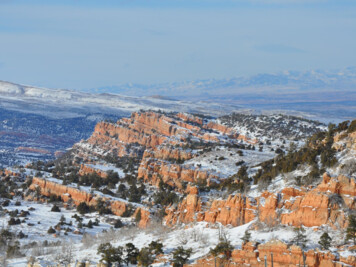
Figure 1. TMP Area OverviewBLM Kingman Travel Management Implementation PlanAugust 20183
1.2. Areas of Special EmphasisThe special designations and areas of special management emphasis within the TMP area include: Arrastra Mountain Wilderness Area Aubrey Peak Wilderness Area Mount Nutt Wilderness Area Mount Tipton Wilderness Area Mount Wilson Wilderness Area Tres Alamos Mountains Wilderness Area Upper Burro Creek Wilderness Area Wabayuma Peak Wilderness Area Warm Springs Wilderness AreaThe ACECs within the TMP area include. Aubrey Peak Bighorn Sheep Habitat ACEC Black Mountains Ecosystem Management ACEC Burro Creek Riparian and Cultural ACEC Carrow-Stephens Ranches ACEC Clay Hills Research Natural Area ACEC Hualapai Mountain Research Natural Area ACEC Joshua Tree Forest – Grand Wash Cliffs ACEC McCracken Desert Tortoise Habitat ACEC Poachie Desert Tortoise Habitat ACEC Three Rivers Riparian ACEC White-margined Penstemon Reserve ACEC Wright-Cottonwood Creeks Riparian and Cultural ACEC1.3. Background of Travel and Transportation ManagementIn the 1980s, in response to Presidential EOs 11644 and 1989, the BLM began to address public concernsregarding the proliferation of unplanned roads and trails and their impact on public land resources and uses. Thisinvolved designating all public lands as either "open," "limited," or "closed" to off-highway vehicle (OHV) use inaccordance with the Code of Federal Regulations, under 43 CFR 8342.1.National BLM policy requires State and Field Offices to develop travel and transportation management plansusing a comprehensive, interdisciplinary approach to integrating travel and transportation management with landuse planning and resource management programs in a process called Travel and Transportation Management orComprehensive Travel and Transportation Management (CTTM; see BLM Handbook 8342, Travel andTransportation Handbook and BLM Manual 1626, Travel and Transportation Management Manual). Thisplanning process addresses all resource values and uses (recreational, traditional, commercial, authorized, andother); and includes all modes of access (e.g., motorized, mechanized, non-motorized, and non-mechanized) andconditions of travel on the public lands.CTTM goals are to: Provide and improve sustainable access for public needs and experiences; Protect natural and cultural resources and settings;BLM Kingman Travel Management Implementation PlanAugust 20184
Promote the safety of public land users; andMinimize conflicts among the various users of public lands.2 Travel Management Planning Process2.1. Route Inventory ProcessThe BLM began conducting route inventories within the planning area in 2004 utilizing existing maps, availableaerial photography, and satellite images. BLM field crews and contractors then utilized four-wheel drive vehicles,motorcycles, horses, mountain bikes, or pedestrian means to travel all identified roads, primitive roads, and trailsto collect route inventory data. Data was also gathered for any additional routes that were observed in the field,but had not been previously identified in the 2004 inventory process.BLM field crews and contractors tracked the inventory using a Global Positioning System (GPS). The GPS notonly recorded spatial data (the route on the map), but also qualitative data regarding the character of the linearfeature (road, primitive road, or trail). Qualitative data was collected, including: Route type (e.g., tertiary road unpaved); Route width (e.g., 2.5 meters); Whether the route is located within a wash; Primary route surface (e.g., gravel or natural); Secondary route surface (e.g., bedrock); Primary route use (e.g., OHV); Secondary route use (e.g., all-terrain vehicle [ATV]); Tertiary route use (e.g., bicycle) Route use level (e.g., heavy); Road number (e.g., 7717); Road name (e.g., Big Wash Road); and Current maintenance (e.g., regular grading).In addition to the data collected regarding the linear character of the route, a series of point features werecollected, including: Hazards (e.g., erosion, overhanging vegetation, etc.); Point site (e.g., abandoned building, campsite, corral, etc.); Photograph points (e.g., historic maintenance); and Generic points (e.g., pipeline crossing).BLM then applied all of the linear and point data to populate a database for routes within the planning area. Thisdatabase or ground transportation linear feature (GTLF) informed the Interdisciplinary Team (IDT) for routeevaluations.2.2. Route Evaluation ProcessA comprehensive route evaluation process was conducted prior to initiation of this TMP. The route evaluationcriteria utilized direction from the BLM national standards related to travel and transportation management,aforementioned inventory data, public comments received during the scoping period, the goals and objectives foreach TMA, and IDT collaboration (Appendix F of the EA).BLM Kingman Travel Management Implementation PlanAugust 20185
The methodology used in the evaluation process documented current uses and resources and identified potentialrisks and benefits of each route on various resources in the KFO. The route evaluation process led to thedevelopment of four travel network alternatives, each emphasizing various levels of access and resourcemanagement.Code of Federal Regulations, under 43 CFR 8342.1 states that all route designations shall be based on theprotection of the resources of the public lands, the promotion of the safety of all users of public lands, theminimization of conflicts among various uses of public lands; and in accordance with the following criteria: Areas and trails shall be located to minimize damage to soil, watershed, vegetation, air, or other resourcesof the public lands, and to prevent impairment of wilderness suitability. Areas and trails shall be located to minimize harassment of wildlife or significant disruption of wildlifehabitats. Special attention will be given to protect endangered or threatened species and their habitats. Areas and trails shall be located to minimize conflicts between off-road vehicle use and other existing orproposed recreational uses of the same or neighboring public lands, and to ensure the compatibility ofsuch uses with existing conditions in populated areas, taking into account noise and other factors. Areas and trails shall not be located in officially designated wilderness areas or primitive areas. Areas andtrails shall be located in natural areas only if the Authorized Officer determines that off-road vehicle usein such locations will not adversely affect their natural, esthetic, scenic, or other values for which suchareas are established.During the route evaluation process, each segment was proposed designated as open, limited, or closed based on43 CFR 8342.1 and the aforementioned evaluation criteria.3 Travel Management Decisions3.1. Plan Purpose and ConformanceThe BLM currently manages a majority of the TMAs under the Kingman ROD and RMP (BLM 1995). The 1995RMP provides long-term goals specific to the planning area’s resources and uses. The RMP currently limits travelin areas to six different categories including (1) existing roads, (2) existing trails, (3) existing washes, (4)designated roads, (5) designated trails, and (6) designated washes. The Travel and Transportation ManagementManual (BLM 2016) provides clarification on the RMP-level decisions for allocation of acres designated OHVlimited versus the TMP implementation-level decisions. The manual describes on page 4-2, Section 4.2 “The typeof limitations applied in an OHV limited area is an implementation-level decision the planning documentsupporting these decisions will describe the conditions under which the limitation will apply and the rationale forwhy the limitation was selected.” Therefore, the TMP serves to adjust the implementation of the RMP allocationsby shifting from an existing route network to a designated route network.A portion of the Poachies TMA is managed under the Lower Gila North MFP (BLM 1981) and ApprovedAmendment (BLM 2005). The Approved Amendment (BLM 2005) provides management decisions regarding thedesignation of OHVs on page 15, specifically RR-9, which limits travel to existing and/or designated roads andvehicle routes. Therefore, the TMP for the Poachies TMA serves to adjust the Approved Amendment allocationby shifting from an existing route network to a designated route network. National goals, regulations, and policesare established by the following documents: Travel and Transportation Handbook (BLM 2012a); Travel and Transportation Manual (BLM 2016); National Management Strategy for Motorized OHV Use on Public Lands (BLM 2001);BLM Kingman Travel Management Implementation PlanAugust 20186
Land Use Planning Handbook (BLM 2005);BLM Instruction Memorandum 2012-067 Clarification of Cultural Resource Considerations for OHVDesignations and Travel Management; andEOs 11644/11989 – Off-Road Vehicle Management Policies.The TMP is considered an implementation or action plan. It specifies the measurable management objectives andactions that will be taken to produce or maintain the desired future conditions described in Section 3.3.3.1.1. Arizona BLM Statewide OHV Regulations and Travel Management PoliciesThe statewide OHV regulations are presented in the BLM State Director’s Guidance for Arizona Land UsePlanning Efforts (Instruction Memorandum AZ-2005-007), BLM Instruction Memorandum AZ-2009-017 StateSpecific Guidance for Implementation of the Arizona OHV Law, and include the following: Permittees (e.g., for hunting, wood gathering, livestock operators) must comply with TMP routedesignations. Exceptions may be made by the Authorized Officer. There shall be no motorized access to harvested game cross country or off of a route designated open tothe public, although use of a mechanized game carrier off of an open route is permitted outside ofdesignated wilderness areas. It is unlawful for a person to camp within one-fourth mile of a natural water hole containing water or aman-made watering facility containing water in such a place that wildlife or domestic stock will be deniedaccess to the only reasonably available water. Use of motorized or mechanized vehicles off of the designated route for the purpose of working livestockis prohibited. State vehicle laws apply to motor vehicle use. There are no posted speed limits on BLM roads, primitive roads or trails. BLM will not develop, endorse or publish road or trail ratings. BLM may describe physical characteristicsof a route. Vehicles are allowed to pull 100 feet off of either side of designated routes. Where pulling off a vehicle100 feet from a route’s centerline is allowed, impacts to natural and cultural resources shall be monitoredon a continuing basis as staffing permits. When monitoring results show effects that exceed limits ofacceptable change, motorized vehicles will not be allowed to pull off 100 feet from any designated routeon either side of the centerline within the impacted area.3.2. BLM Administrative Determination on R.S. 2477A TMP is not intended to provide evidence, bearing on, or address the validity of any Revised Statute (R.S.) 2477assertions. R.S. 2477 rights are determined through a process that is entirely independent of the BLM's planningprocess. Consequently, this TMP did not take into consideration R.S. 2477 evidence. The BLM bases travelmanagement planning on purpose and need related to resource uses and associated access to public lands andwaters given consideration to the relevant resources. At such time as a decision is made on R.S. 2477 assertions,the BLM will adjust its travel routes accordingly.The BLM will continue to consider granting Right-of-Ways (ROWs) for or including vehicular use. ROWs willbe processed under project specific NEPA analysis and be subject to any requirements stemming from saidanalysis. Upon granting of ROWs including roads or vehicular ways, these will automatically be incorporated intothis TMP on a case-by-case basis.BLM Kingman Travel Management Implementation PlanAugust 20187
3.3. Desired OutcomesDesired outcomes (or goals and objectives) provide overarching direction for BLM actions in meeting theagency’s legal, regulatory, policy, and strategic requirements. Goals are broad statements of desired outcome, butgenerally are not quantifiable. Objectives are more specific statements of a desired condition that may include ameasurable component. Desired outcomes are expressed in the Kingman ROD and RMP (BLM 1995), as well asthe Lower Gila North MFP (BLM 1981) and Approved Amendment (BLM 2005) as desired future conditions(DFCs), and represent land or resource conditions that are expected to result if planning goals and objectives arefully achieved.3.3.1. Goals, Objectives and Guidelines for General Management AreasManagement guidelines for these areas will remain similar to current management practices, except for thedesignation of OHV use. Existing laws, regulations, policies and procedures will be followed. The followingmanagement goals, objectives and guidelines will apply. Provide essential motorized access to non-Federal lands, across BLM-administered lands, and recognizeprior existing access rights. Reduce unauthorized proliferation of travel routes and minimize impacts to identified resource valuesfrom routes that provide non-essential access. Continue to provide adequate access for the maintenance and management of wildlife, livestock grazing,minerals, realty, fire, cultural resources, and a multitude of recreational activities and experiences. Designate OHV use as open or limited to existing roads, trails and washes. Provide for semi-primitive motorized and non-motorized recreation. Designated routes will be signed and mapped for public use in a manner consistent with other Federalland management agencies and BLM national policy. Designated routes will provide for a wide variety of trail-based recreational opportunities in a manner thatwill reduce existing or future user conflicts.3.3.2. Goals, Objectives and Guidelines for Areas Requiring Special ManagementManagement guidelines for these areas of public lands (e.g., ACECs) will focus on managing sensitive resourceswhile allowing for multiple use. The BLM will manage authorized uses and prepare management prescriptions toprotect unique resources. The following management guidelines will apply. Minimize surface disturbance. Develop educational materials and interpretive sites to increase the public’s understanding of sensitiveresources. Develop low impact recreation opportunities. Limit the use of OHVs to designated roads, trails, and washes. Limit OHV use in riparian areas to designated roads and trails. Close and rehabilitate roads where there is no public or administrative need to keep them open. Designate OHV use as limited or closed. Provide for semi-primitive motorized and non-motorized recreation.BLM Kingman Travel Management Implementation PlanAugust 20188
3.4. Route DesignationsThe actions listed below are meant to implement the goals and objectives of this TMP, as well as incorporatetravel management actions as required by the Kingman ROD and RMP (BLM 1995), as well as the Lower GilaNorth MFP (BLM 1995) and Approved Amendment (BLM 2005).As stated in Section 3.1, the TMP serves to adjust the implementation of the RMP allocations by shifting from anexisting route network to a designated route network. The primary action of this plan is to designate the travelnetwork. The proposed route system has been designed to provide access and to enhance recreation whileprotecting resources. The route designation type describes the kind of user that can utilize the route, how the usecan occur, and when access to the route is allowed:Open: Routes where all types of motorized and mechanized vehicle use is permitted at all times, and subjectto the operating regulations and vehicle standards set forth in 43 CFR 8341 and 8342.Limited: Limitation may be based on number or types of vehicles, size, season of use, or users with specialauthorization.Seasonal Closure: Routes that are closed to public motorized and mechanized use during certain seasons ortimes.OHV Width: Routes that are restricted to use by non-motorized, motorcycle, or OHVs with a width of50 inches or less.Authorized Users: These routes are available to the public for non-motorized travel only. Routes designatedfor authorized motorized use only, often termed “administrative access,” are for motorized travel forpurposes specifically related to completing BLM work or specific work completed by a permittee associatedwith an approved BLM ROW, permit, or lease. Authorizations may be granted on a case-by-case basis withwritten approval from the BLM Authorized Officer, with the exception of valid existing rights includingROWs, and current easements. Routes designated as authorized use only are also subject to seasonalclosures, vehicle size class restrictions and ongoing monitoring.Non-motorized: Routes limited to non-motorized uses, such as bicycle, horseback, or hiking.Non-mechanized: Routes limited to hikers and equestrian travel.Closed: Routes closed to motorized and mechanized use due to resource concerns or conflicts. The routesmay be available for foot and equestrian travel. These routes may involve physical closure structures with theultimate goal of being restored to a vegetated condition.Four different route types are used to describe the intended use designation: road, primitive road, temporary route,and trail (BLM 2006). These terms are defined in detail below:Road: A linear route declared a road by the owner, managed for use by low-clearance vehicles having fouror more wheels, and maintained for regular and continuous use.Primitive Road: A linear route managed for use by four-wheel drive or high-clearance vehicles. Theseroutes do not customarily meet any BLM road design standards.Temporary Route: Temporary routes are
The Kingman ROD and RMP (BLM 1995), as well as the Lower Gila North MFP (BLM 1981) and Approved Amendment (BLM 2005), designated 418,887 acres as closed to vehicle use per the Arizona Desert Wilderness Act of 1990, which designated nine wilderness areas within the planning area. The Wilderness Act of 1964 and

![State Protocol Agreement Between the Colorado State Director [Sd] of .](/img/43/co-20protocol.jpg)