Transcription
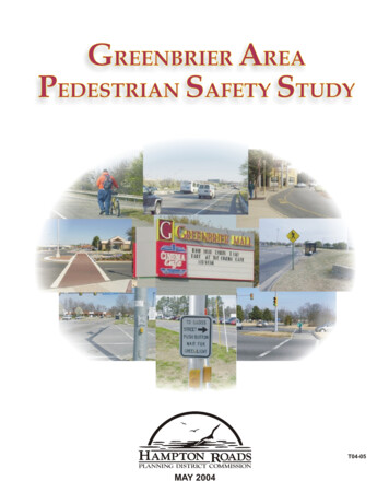
GREENBRIER AREAPEDESTRIAN SAFETY STUDYT04-05MAY 2004
HAMPTON ROADS PLANNING DISTRICT COMMISSIONCHESAPEAKECLARENCE V. CUFFEEDEBBIE RITTER* WILLIAM E. WARDPOQUOSON* CHARLES W. BURGESS, JR.GORDON C. HELSEL, JR.FRANKLINMARK S. FETHEROLF* ROWLAND L. TAYLORPORTSMOUTHJ. THOMAS BENN, III* C. W. McCOYCAMERON C. PITTSGLOUCESTER COUNTYJOHN J. ADAMS, SR.* WILLIAM H. WHITLEYSOUTHAMPTON COUNTY* MICHAEL W. JOHNSONCHARLETON W. SYKESHAMPTONVACANCYGEORGE E. WALLACE* PAIGE V. WASHINGTON, JR.SUFFOLKE. DANA DICKENS, III* R. STEVEN HERBERTISLE OF WIGHT COUNTYW. DOUGLAS CASKEY* STAN D. CLARKJAMES CITY COUNTY* BRUCE C. GOODSONSANFORD B. WANNER.NEWPORT NEWSCHARLES C. ALLEN* JOE S. FRANKEDGAR E. MARONEYNORFOLK* PAUL D. FRAIMDONALD L. WILLIAMSREGINA V.K. WILLIAMSBARCLAY C. WINNW. RANDY WRIGHTSURRY COUNTYREGINALD O. HARRISON* TERRY D. LEWISVIRGINIA BEACHHARRY E. DIEZELMARGARET L. EURE* LOUIS R. JONESMEYERA E. OBERNDORFPETER W. SCHMIDTJAMES K. SPOREJAMES L. WOODWILLIAMSBURGJACKSON C. TUTTLE, II* JEANNE ZEIDLERYORK COUNTY* JAMES O. McREYNOLDSTHOMAS G. SHEPPERD, JR.*EXECUTIVE COMMITTEE MEMBERPROJECT STAFFARTHUR L. COLLINSEXECUTIVE DIRECTOR/SECRETARYDWIGHT L. FARMERCAMELIA RAVANBAKHATSAMUEL S. BELFIELDJOHN A. BISHOPDEPUTY EXECUTIVE DIRECTOR, TRANSPORTATIONPRINCIPAL TRANSPORTATION ENGINEERTRANSPORTATION ENGINEERTRANSPORTATION ANALYSTROBERT C. JACOBSMICHAEL R. LONGBRIAN MILLERRACHAEL V. PATCHETTDIRECTOR OF GRAPHIC & PRINTING SERVICESGRAPHIC ARTIST/ILLUSTRATOR TECHNICIAN IIGRAPHIC TECHNICIAN IIREPROGRAPHIC SUPERVISOR
GREENBRIER AREAPEDESTRIAN SAFETY STUDYThis report was included in the Work Programfor Fiscal Year 2003-2004, which was approved by theCommission and the Metropolitan Planning Organizationat their meetings of March 19, 2003.PREPARED BY:MAY 2004T04-05
Report DocumentationMay 2004: Final ReportREPORT DOCUMENTATIONTITLE:REPORT DATEGreenbrier Area Pedestrian Safety StudyMay 2004GRANT/SPONSORINGAGENCYFHWA/VDOT/LOCAL FUNDSAUTHORS:ORGANIZATION NAME,ADDRESS AND TELEPHONESamuel S. BelfieldJohn A. BishopHampton Roads PlanningDistrict Commission723 Woodlake DriveChesapeake, Virginia 23320(757) 420-8300http://www.hrpdc.orgABSTRACTThe City of Chesapeake has requested that a pedestrian safety study be undertaken for theGreenbrier area to guide future development and to be included in the City’s comprehensive plan. Thisarea serves as one of the largest retail sites in Hampton Roads, and numerous citizens have expressedconcerns with crossing Greenbrier Parkway, which is a busy six lane arterial roadway. Currently, an autodependent development pattern exists surrounding Greenbrier Mall and along Greenbrier and VolvoParkways which makes it difficult for pedestrian movement. The overall goal is to create a safe, mixedused, walkable, and urban environment for automobiles, pedestrians, bicyclists and transit. Most of thefocus of this study is on improving pedestrian linkages and connections between existing and proposeddevelopments and transit stops to create a safe and seamless network for pedestrians.This study analyzes pedestrian needs and identifies improvements to address those needs. Thisstudy includes general recommendations for sidewalks, signage, curb ramps, crosswalks, refuge islands,stop bars, and pedestrian signals along study area roadways and intersections to achieve thesepedestrian safety and connectivity objectives. The recommendations of this study take into accountexisting and future land uses, traffic, transit, and pedestrian conditions.ACKNOWLEDGMENTSThis report was prepared by the Hampton Roads Planning District Commission (HRPDC) incooperation with the U.S. Department of Transportation (USDOT), the Federal Highway Administration(FHWA), the Virginia Department of Transportation (VDOT), and the City of Chesapeake. The contentsof this report reflect the views of the staff of the Hampton Roads Area Metropolitan Planning Organization(MPO). The MPO staff is responsible for the facts and the accuracy of the data presented herein. Thecontents do not necessarily reflect the official views or policies of the FHWA, VDOT, or HRPDC. Thisreport does not constitute a standard, specification, or regulation. FHWA or VDOT acceptance of thisreport as evidence of fulfillment of the objectives of this planning study does not constituteendorsement/approval of the need for any recommended improvements nor does it constitute approval oftheir location and design or a commitment to fund any such improvements. Additional project levelenvironmental impact assessments and/or studies of alternatives may be necessary.Greenbrier AreaPedestrian Safety Studyi
Table of ContentsMay 2004: Final ReportTABLE OF CONTENTSREPORT DOCUMENTATION . iLIST OF MAPS . iiiINTRODUCTION. 1Purpose of Study . 1Study Area . 1EXISTING CONDITIONS. 3Roadway Characteristics . 3Average Daily Traffic. 3Roadway Level of Service . 3Pedestrian Crossing at Intersections . 4Pedestrian Accident Data . 4Pedestrian Facilities. 4Transit . 4Pedestrian Activity and Land Use . 7EXISTING PEDESTRIAN FACILITY DEFICIENCIES . 9FUTURE CONDITIONS . 14Traffic Conditions . 14Bus Transit . 14Light Rail Transit . 14Pedestrian Activity and Land Use . 16CROSSING ALTERNATIVES FOR GREENBRIER PARKWAY. 18At-Grade Crossings . 18Grade-Separated Crossings . 20Recommended Crossing Alternative . 21Future Considerations. 22PROPOSED IMPROVEMENTS . 23Sidewalk Recommendations. 23Intersection Recommendations . 25Other Recommendations . 29Improvement Priorities . 30Estimated Costs . 30CONCLUSIONS. 38Greenbrier AreaPedestrian Safety Studyii
Table of ContentsMay 2004: Final ReportLIST OF MAPSMAP 1Greenbrier Study Area . 2MAP 2Existing Pedestrian and Transit Facilities . 6MAP 3Existing Land Use . 8MAP 42026 Regional Transit Plan (Chesapeake) . 15MAP 5Hampton Roads Regional Light Rail Transit System. 14MAP 6Chesapeake LRT Corridor Alternatives . 16MAP 7Potential Greenbrier Light Rail Transit Option . 17MAP 8Walking Distances from the Perimeter of Greenbrier Mall. 18MAP 9Greenbrier Proposed Pedestrian Facilities . 31MAP 10Conceptual Intersection Layout of Proposed Improvements –Greenbrier Parkway & Jarman Road . 32MAP 11Conceptual Intersection Layout of Proposed Improvements –Greenbrier Parkway & Crossways Boulevard/Greenbrier Mall Entrance . 33MAP 12Conceptual Intersection Layout of Proposed Improvements –Greenbrier Parkway & Eden Way . 34MAP 13Conceptual Intersection Layout of Proposed Improvements –Greenbrier Parkway & Greenbrier Market Square Main Entrance . 35MAP 14Conceptual Intersection Layout of Proposed Improvements –Greenbrier Parkway & Volvo Parkway. 36MAP 15Priority Levels for Proposed Pedestrian Facilities. 37Greenbrier AreaPedestrian Safety Studyiii
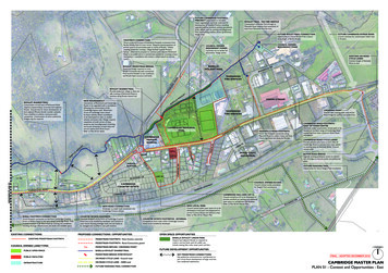
IntroductionMay 2004: Final ReportINTRODUCTIONThe City of Chesapeake has requested that apedestrian safety study be undertaken for theGreenbrier area to guide future development andto be included in the City’s comprehensive plan.This area serves as one of the largest retail sitesin Hampton Roads, and numerous citizens haveexpressed concerns with crossing GreenbrierParkway, which is a busy six lane arterialroadway.Currently, an reenbrier Mall and along Greenbrier and VolvoParkways which makes it difficult for pedestrianmovement. The overall goal is to create a safe,mixed-used, walkable, and urban environment forautomobiles, pedestrians, bicyclists and transit.Most of the focus of this study is on improvingpedestrian linkages and connections betweenexisting and proposed developments and transitstops to create a safe and seamless network forpedestrians.By improving the pedestrian system andconnectivity, auto trips made to/from the mall,residential areas, and other activitygenerators could be reduced slightlyThe Virginia Department of Transportation(VDOT) has recently adopted a policy that allhighway construction projects be initiated with thepresumption that they will accommodate bicyclingand walking, effective on March 18, 2004. Thisinitiative signifies the importance of integratingbicycle and pedestrian facilities into thetransportation network.Study AreaThe study area is shown in Map 1 on page 2. Itextends to the north along Interstate 64 andincludes the hotels along Crossways Boulevard,to the east along River Birch Run and Eden Wayadjacent to medium density residential areas,Volvo Parkway on the south side, and alongCrossways Boulevard to the west.Purpose of StudyThe goal of the Greenbrier Area PedestrianSafety Study is to analyze pedestrian needs andidentify improvements to address those needs.This study takes into account existing and futureland uses, traffic, transit, and pedestrianconditions. Specific concepts addressed in thisstudy include:Providing pedestrian accommodations for thegeneral public, including the disabledcommunityPedestrian connections among hotels,GreenbrierMall,ShoppingCenters,residential areas, and other land usesGreenbrier Mall is the primary activity generator in one ofthe largest retail sites in Hampton Roads.Safe and convenient pedestrian movementacross major streetsFeasibility of grade-separated crossing(pedestrian overpass) versus at-gradecrossingacrossGreenbrierParkwayconnecting the Greenbrier Mall Site to theCrossways Center SiteConnecting existing sidewalks via proposedsidewalks to create a pedestrian friendlynetwork for the Greenbrier study areaSafe and convenient pedestrian connectionsto bus/transit stopsCitizens have expressed a need for pedestrian facilitiesalong Greenbrier Parkway.Greenbrier AreaPedestrian Safety Study1
IntroductionMay 2004: Final ReportMap 1Greenbrier Study AreaCity of Chesapeake (VA)Greenbrier AreaPedestrian Safety Study2
Existing ConditionsMay 2004: Final ReportEXISTING CONDITIONSAverage Daily TrafficRoadway CharacteristicsThe following table provides Average Daily Traffic(ADT) counts for primary roadways in the studyarea.The Greenbrier area is one of the highesttraveled areas in the City of Chesapeake,particularly during morning and afternoon peakhours. This area contains the mall, large andsmall retail, office parks, restaurants, hotels, andother businesses that generate large trafficvolumes. Roadways included in the study areaand their characteristics are provided in the tablebelow.NumberRoadway Name of t(mph)45Volvo Parkway(Crossways Blvd toGreenbrier 5Jarman Road4Yes35Kristina WayExecutiveBoulevard43,629 42,268GreenbrierParkwayEden Way & I-6482,280 78,141VolvoParkwayBattlefield Blvd &Greenbrier Pkwy23,835 27,132VolvoParkwayGreenbrier Pkwy &Fairway Reach Rd25,351 21,032Eden WayVolvo Pkwy & WhiteOak CrossingEden WayWhite Oak Crossing14,970& Greenbrier PkwyN/AEden WayGreenbrier Pkwy &Crossways Blvd8,818N/ACrosswaysBoulevardVolvo Pkwy &Eden Way9,823N/A9,600N/AHRPDC staff recently completed a roadwaysegment level of service analysis1 of majorroadways in the City of Chesapeake. Below arethe results for key roadway segments in the Volvo Pkwy &Eden WayDEGreenbrierParkwayEden Way & I-64FFVolvoParkwayBattlefield Blvd &Greenbrier PkwyCCVolvoParkwayGreenbrier Pkwy &Fairway Reach RdCC1 Hampton Roads Planning District Commission,“Chesapeake Level of Service Study”, June 2003.Greenbrier AreaPedestrian Safety StudyADT2002N/A – Not AvailableEden WayRiver Birch RunADT1999Roadway Level of Service4(Bayberry Pl toVolvo Pkwy)Volvo Pkwy &Eden Way45Eden Way(Greenbrier Pkwy toBayberry Pl)GreenbrierParkway35Eden Way(Crossways Blvd toGreenbrier Pkwy)Between45Volvo Parkway(Greenbrier Pkwy toEden Way)RoadwayName3
Existing ConditionsMay 2004: Final ReportPedestrian Crossing at IntersectionsPedestrian FacilitiesThe following list provides the number of lanespedestrians must cross at major intersections inthe study area. The number of lanes variesdepending on which side of the roadway is beingcrossed.The existing pedestrian facilities (sidewalks andcrosswalks) for the entire study area are providedin Map 2 on page 6. This map clearly showswhere gaps in the pedestrian facility network arepresent; (1) surrounding Greenbrier Mall, (2)along Greenbrier Parkway, (3) east end ofCrossways Boulevard, (4) along portions of EdenWay, (5) along River Birch Run, and (6) alongVolvo Parkway.Greenbrier Parkway@ Crossways Blvd/Mall Entrance@ Eden Way@ Volvo Parkway7/9 lanes7/9 lanes6/7 lanesTransitVolvo Parkway@ Crossways Boulevard@ Progressive Drive@ Greenbrier Parkway@ Eden Way6/7 lanes5/6 lanes6/7 lanes5 lanesEden Way@ Greenbrier Parkway@ River Birch Run@ Volvo Parkway5/7 lanes5/6 lanes3 lanesCrossways Boulevard/Main Mall Entrance@ Greenbrier Parkway5/6 lanesRiver Birch Run@ East Mall Entrance@ Eden Way5/6 lanes2/4 lanesThere are currently two Hampton Roads Transit(HRT) bus routes serving the Greenbrier Mallarea (shown on Map 2): Runs from Chesapeake Square ShoppingCenter and Greenbrier Mall to Military Circleto Naval Station Norfolk.Offers Weekday and Weekend Service. The following table summarizes pedestrianvehicle accidents from January 1999 throughDecember 2003. Two accidents occurred at theintersection of Greenbrier Parkway and EdenWay, where no crosswalks are available. Therewere no fatalities.DateRoute 22 (Naval Station/Greenbrier-IndianRiver Park & Ride Lot)From Greenbrier Mall Park & Ride Lot andIndian River Park & Ride Lot to Naval StationNorfolk to Hampton Blvd. and Lexan Ave.Pedestrian Accident DataDistancefromCrossStreet (ft)Route 15 (Naval Station Norfolk/Robert HallBlvd.)Offers Weekday Service Only.Bus stops are shown on Map 2 for both routes.The bus stop area for Route 22 is also adesignated HRT/TRAFFIX Park & Ride Lot,which provides Greenbrier ridesharers with free,all-day parking and is a convenient place to meeta carpool or vanpool. Currently, approximately30 ridesharers utilize the Park and Ride lot on amonthly basis. TRAFFIX is a regional programfor transportation alternatives.RoadwayNameCrossStreetEden WayRiver BirchRun012/26/99Eden WayRiver BirchRun03/2/00Eden WayGreenbrierParkway08/29/00GreenbrierParkwayEden Way010/29/00Greenbrier Mall is one of the major transitgenerators on the Southside. HRT bus ridershipfor Routes 15 and 22 for each month in 2003 isprovided on the following page. Routes 15 and22 average approximately 350 and 30passengers per day respectively. For Route 15,which offers weekday and weekend service,ridership is about 40% lower on weekendscompared to weekdays.River Birch River BirchTrailRun05/2/01It is important to note from Map 2 that there arecurrently no sidewalks/crosswalks around theGreenbrier AreaPedestrian Safety Study4
Existing ConditionsMay 2004: Final ReportMall that provide a direct connection from theresidential and surrounding areas to the busstops.Route 22 – 2003 Monthly Ridership for Chesapeake(Weekday Service)MonthRoute 15MonthlyRidership(7 dayservice)JanuaryDailyAvg.Route 0636December10,34633459427Data not available2003 HRT Bus Ridership (Chesapeake Only)Data Source: Hampton Roads Transit*Ridership was lower due to Hurricane IsabelN/A – Not AvailableData Source: Hampton Roads TransitRoute 15 – 2003 Monthly Ridership for Chesapeake(Weekday and Weekend Service)Data Source: Hampton Roads TransitGreenbrier AreaPedestrian Safety Study5
Existing ConditionsMay 2004: Final ReportMap 2Existing Pedestrian andTransit FacilitiesCity of Chesapeake (VA)Greenbrier AreaPedestrian Safety Study6
Existing ConditionsMay 2004: Final ReportGreenbrier Parkway & Crossways BoulevardPedestrian Activity and Land UseThe primary generator of pedestrian activity in thestudy area is Greenbrier Mall. Other significantactivity centers include the residential areas eastof the Mall and Greenbrier Parkway, theconcentration of hotels to the north alongCrossways Boulevard, and the restaurant andretail areas along Greenbrier Parkway. Childrenhave been seen riding their bicycles along RiverBirch Run and Greenbrier Parkway due to theabsence of sidewalks. The existing land usedesignations for the Greenbrier study area areshown on Map 3 on page 6.Time11am - 1pmEastbound acrossGreenbrier Pkwy fromCrossways Blvd24pm - 6pmNo pedestrian activity0PedestrianCount7am - 9amEastbound acrossGreenbrier Pkwy from EdenWay (west side)17am - 9amWestbound acrossGreenbrier Pkwy from EdenWay (east side)17am - 9amSouthbound across EdenWay from Greenbrier Pkwy(north side)211am - 1pmEastbound acrossGreenbrier Pkwy from EdenWay (west side)111am - 1pmWestbound acrossGreenbrier Pkwy from EdenWay (east side)111am - 1pmNorthbound across EdenWay from Greenbrier Pkwy(south side)14pm - 6pmEastbound on Eden Way toSouthbound alongGreenbrier Pkwy44pm - 6pmEastbound on Eden Way toNorthbound along GreenbrierPkwy14pm - 6pmNorthbound across EdenWay from Greenbrier Pkwy(south side)1Looking across Greenbrier Pkwy from Greenbrier MallEntrance at Crossways, where no crosswalks currently exist.Looking across Greenbrier Pkwy from east side ofEden Way, where no crosswalks currently exist.2 October 21-23, 2003Greenbrier AreaPedestrian Safety Study2It is important to note that pedestrian counts wereonly taken for one day at these two locations.Currently, these intersections, as well as others inthe study area, do not have crosswalks andpedestrian signals, which discourage pedestrianactivity.Crosswalks and pedestrian signalsincrease pedestrian safety by providing highervisibility to motorists and designated crossingtimes. More pedestrian activity typically occurswhen the weather is more seasonable.Greenbrier Parkway and Eden WayDirection of TravelPedestrianCountWestbound acrossGreenbrier Pkwy from MallEntrance7am - 9amPedestrian counts were taken by the City in lateOctober 20032 for a typical midweek weekday(Tuesday-Thursday) at two key intersectionsalong Greenbrier Parkway for one morning, midday, and afternoon time period: (1) GreenbrierParkway and Eden Way (2) Greenbrier Parkwayand Crossways Boulevard.The results areprovided in the following tables.TimeDirection of Travel7
Existing ConditionsMay 2004: Final ReportMap 3Existing Land UseCity of Chesapeake (VA)Greenbrier AreaPedestrian Safety Study8
Existing Pedestrian Facility DeficienciesMay 2004: Final ReportEXISTING PEDESTRIANFACILITY DEFICIENCIESPedestrian facilities, such as sidewalks andcrosswalks, are virtually non-existent on thesurrounding roadways and driveways atGreenbrier Mall, along River Birch Run, alongGreenbrier Parkway, along Volvo Parkway, alongsome sections of Eden Way, and the easternportion of Crossways Boulevard (refer to Map 2).A comprehensive pedestrian network doescurrently exist in the adjacent neighborhoodstreets and the other study area roadways. Thekey objective is to provide safe and convenientconnections between these existing pedestrianfacilities to provide a pedestrian friendly networkfor the entire Greenbrier area.Sidewalks are needed surrounding HRT bus stops.Greenbrier Mall AreaDeficiencies observed at the Greenbrier Mall areainclude:Lack of sidewalks around Mall Ring Road(Circulation roadway)No sidewalks leading up to HRT bus stopsLack of sidewalks and crosswalks connectingMall Ring Road and other driveway mallentrances to sidewalks surrounding the mallbuildingNo curb ramp at the existing crosswalklocation across Mall Ring Road (connectingSenior residential area to northeast parkinglot at the mall)Greenbrier Mall Main Entrance (looking east). Nosidewalks currently exist and shrubbery extends to curb.Lack of sidewalks, crosswalks, and medianrefuges for mall entrancesPedestrians currently walk along the edge of the roadwayat some Mall entrances, which is extremely unsafe.There is currently available space for sidewalksalong Mall Ring Road.Greenbrier AreaPedestrian Safety Study9
Existing Pedestrian Facility DeficienciesMay 2004: Final ReportGreenbrier Mall Main Entrance (looking west at thesame location as the photo above). A path behind theshrubbery has been worn down by pedestrian traffic.Mall Ring Road location connecting senior residentialarea to the northeast parking lot at the mall. Needs curbramp for persons in wheelchairs and sidewalks leadingup to the existing crosswalk.River Birch RunDeficiencies observed along River Birch Runinclude:No sidewalks on either side of River BirchRun from Eden Way to the northeasternresidential areasLacks crosswalks across River Birch Run atthe east Greenbrier Mall driveway entranceLacks crosswalk and pedestrian signalacross River Birch Run at the Eden WayintersectionGreenbrier Mall driveway entrances do not have crosswalksor median refuges for pedestrians to safely cross.Sidewalks do not provide seamless connections aroundthe mall or to driveway mall entrances.Greenbrier AreaPedestrian Safety StudyPedestrian push buttons and crosswalks currently existfor two approaches of the intersection of Eden Way andRiver Birch Run; however, no pedestrian signals arepresent to alert pedestrians when it’s safe to cross.10
Existing Pedestrian Facility DeficienciesMay 2004: Final ReportGreenbrier ParkwayDeficiencies observed along Greenbrier Parkwayinclude:No sidewalks on either side of GreenbrierParkway from Volvo Parkway to Interstate 64except for one small section on the westernside just south of Eden WayLacksat-gradeorgrade-separatedpedestrian crossing across GreenbrierParkway from Greenbrier Mall to theCrossways Shopping Center site.Lack of crosswalks and pedestrian signalacross Greenbrier Parkway at Eden Way andat the Greenbrier Market Shopping Centermain entranceLooking west across Greenbrier Parkway at Eden Way.Sidewalks lead to the intersection on both sides of EdenWay, but no crosswalk or pedestrian signal is provided.Lacks crosswalk and pedestrian signalacross Greenbrier Parkway for the northernpart of the intersection with Volvo ParkwayNo sidewalks currently exist for a majority ofGreenbrier Parkway in the study area.A worn path along Greenbrier Parkway demonstratespedestrian activity.An observed pedestrian walking along GreenbrierParkway between Eden Way and Volvo Parkway,where no sidewalks currently exist.Greenbrier AreaPedestrian Safety Study11
Existing Pedestrian Facility DeficienciesMay 2004: Final ReportThere are no sidewalks along Volvo Parkway fromGreenbrier Parkway to Crossways Boulevard.Pedestrians and bicyclists travel along GreenbrierParkway over Interstate 64 despite the absence ofsidewalks and crosswalks, which raises safety concerns.Volvo ParkwayDeficiencies observed along Volvo Parkwayinclude:No sidewalks on either side of Volvo Parkwayfrom Greenbrier Parkway to CrosswaysBoulevard (There are also no sidewalksalong the north side of Volvo Parkway fromCrossways Boulevard to Sams Drive.Sidewalks on the south side of VolvoParkway begin just west of train tracks about600 feet west of Crossways Boulevard andcontinue to Battlefield Boulevard)Incomplete sidewalks at the intersection of VolvoParkway and Progressive DriveLack of sidewalk along the north side ofVolvo Parkway from Greenbrier Parkway tothemixeduserestaurant/businessdevelopment (about 900 feet to the east)Eden WayDeficiencies observed along Eden Way include:Lacks crosswalks at the intersection of VolvoParkway and Crossways BoulevardIncomplete sidewalk along east side of EdenWay from Volvo Parkway to approximately1500 feet north of that locationLacks crosswalks at the intersection of VolvoParkway and Executive BoulevardIncomplete sidewalk along west side of EdenWay from about 600 feet north of Mill LakeQuarter to about 350 feet past Cypress PlaceIncomplete crosswalks at the intersection ofVolvo Parkway and Progressive DriveLack of sidewalk along the north side of EdenWay from about 200 feet east of River BirchRun to Greenbrier ParkwayLacks crosswalks and pedestrian signalacross Volvo Parkway at the GreenbrierParkway intersectionLacks crosswalks and pedestrian signalacross Eden Way at Greenbrier ParkwayGreenbrier AreaPedestrian Safety Study12
Existing Pedestrian Facility DeficienciesMay 2004: Final ReportLacks crosswalks across Eden Way at thesoutheast mall entrance drivewayLacks crosswalk and pedestrian signalacross Eden Way for the eastern part of theintersection with River Birch RunNo mid-block crosswalks across Eden Wayjust north of Mill Lake QuarterNo crosswalk to allow pedestrians to safely change sidesto access other portion of sidewalk along Eden Way.Crossways BoulevardDeficienciesobservedBoulevard include:alongCrosswaysNo sidewalks on either side of CrosswaysBoulevard from Greenbrier Parkway toJarman RoadPedestrians must walk on grass when traveling alongsome sections of Eden Way.LackscrosswalkacrossCrosswaysBoulevard for the western side of theintersection with Greenbrier ParkwayNo mid-block crosswalk across CrosswaysBoulevard in between Greenbrier Parkwayand Jarman RoadLack of crosswalks at the interse
Greenbrier Mall is the primary activity generator in one of the largest retail sites in Hampton Roads. Introduction May 2004: Final Report Greenbrier Area 2 Pedestrian Safety Study Map 1 Greenbrier Study Area City of Chesapeake (VA) Existing Conditions May 2004: Final Report G .