Transcription
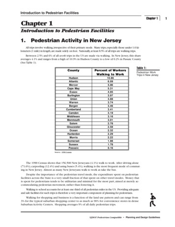
Introduction to Pedestrian FacilitiesChapter 1Chapter 1Introduction to Pedestrian Facilities1.Pedestrian Activity in New JerseyAll trips involve walking, irrespective of their primary mode. Many trips, especially those under 1.6 kilometers (1 mile) in length, are made solely on foot. Nationally, at least 8.5% of all trips are walking trips.Between 2.5% and 6% of all work trips in the US are made via walking. In New Jersey, this shareaverages 4.1% and ranges from a high of 10.9% in Hudson County to a low of 0.2% in Passaic County(See Table 1).CountyPercent of WorkersWalking to WorkHudsonAtlanticMercerCape 81.780.16Table 1:Pedestrian WorkTrips in New JerseySource: 1990 CensusThe 1990 Census shows that 156,500 New Jerseyans (4.1%) walk to work. After driving alone(71.6%), carpooling (12.4%) and using buses (5.4%), walking is the most frequent mode of commuting in New Jersey. Almost as many New Jerseyans walk to work as take the bus.Despite the importance of the pedestrian travel mode, the expenditure spent on pedestrianfacilities across the State is a very small fraction of that spent on other travel modes. Money thatis spent for pedestrians tends to be utilitarian and minimal for the most part, aimed at merely accommodating pedestrian movement, rather than fostering it.Walking to school accounts for at least one third of all pedestrian miles in the US. Providing adequateand safe facilities for such trips is therefore a very important component of planning for pedestrians.Walking for shopping and business is a function of the land use pattern and can range from3% for the typical suburban shopping center to as much as 90% for convenience stores in denseSuburban Activity Centers. Shopping averages 9% of all daily pedestrian trips.NJDOT Pedestrian Compatible Planning and Design Guidelines1
2Recreational walking and jogging is increasingly popular as public awareness of healthand fitness expands. Social and recreational walking trips account for 12% of all pedestriantrips. Almost 90% of suburban area residents walk for exercise and recreation. Up to onethird do so at least five days per week and more than one-third also run or jog. The self-evident benefits of both recreational and functional walking in terms of health and energy savings are complemented by more subtle benefits that include increased neighborliness and aheightened awareness of the manmade and natural environment.Data on pedestrian accidents shows that most accidents (around 60%) occur between 2:00PM and 10:00 PM, peaking with the rush hour. Most susceptible to accidents are children, teenagers and the elderly. About one-third of the victims of both urban and rural accidents are children under 10 years of age; teenagers account for another 19% (urban) to 29% (rural); and theelderly (65 years plus) represent another 6% (rural) and 19% (urban) of accidents. The most common types of urban and rural pedestrian accidents - dart-outs, mid-block and intersection-dash can all likely be reduced through proper design for pedestrians.These Planning & Design Guidelines address the needs of pedestrians in all of the abovesettings and for all of these trip purposes. The Guidelines are concerned with defining appropriate facilities and design criteria to accommodate and foster pedestrian movement as well asto make it safer.Since these guidelines are a companion document to NJDOT’s Bicycle Compatible Roadways and Bikeways, it is appropriate to discuss the relationship between pedestrian and bicycle domains in general terms. While both functions need to be carefully planned for, themovement characteristics and needs of pedestrians and bicycles differ in obvious ways. Thegreater speed and size of the bicycle and rider means that, in general, bicycles are best accommodated as part of the roadway and not on sidewalks. Additional outside lane dimensions or widened shoulders perform this function most typically. For recreational pathwaysand other unique circumstances (e.g., certain bridges), pedestrian and bicycle movement issometimes combined if adequate width can be provided and usage is not intense.2.Goals and Visions for Pedestrian UseThe Intermodal Surface Transportation Efficiency Act (ISTEA) set a new direction for surfacetransportation in America that is enunciated in its statement of policy:“to develop a National Intermodal Transportation System thatis economically efficient, environmentally sound, provides thefoundation for the Nation to compete in the global economy andwill move people and goods in an energy efficient manner.”Provisions for walking, with its potential for providing economically efficient transportation, became an important policy goal of ISTEA. The Secretary of Transportation was directed to conduct a national study that developed a plan for the increased use and enhanced safety of bicycling and walking.The National Bicycling and Walking Study - Transportation Choices for a Changing America presents aplan of action for activities at the Federal, State and local levels for meeting the following goals: To double the current percentage (from 7.9 percent to 15.8 percent) of total trips madeby bicycling and walking; and To simultaneously reduce by 10 percent the number of bicyclists and pedestrians killedor injured in traffic crashes.The potential for increasing the number of pedestrian trips is evident in the National Personal Transportation Survey, which shows that more than a quarter of all trips are 1.6 kilometers (one mile) or less, and40 percent are 3.2 kilometers (two miles) or less. Almost half are 4.8 kilometers (three miles) or less andtwo-thirds are 8.0 kilometers (five miles) or less. Approximately 53 percent of all people live less than 3.2kilometers (two miles) from the nearest public transportation route.NJDOT Pedestrian Compatible Planning and Design Guidelines
Introduction to Pedestrian FacilitiesChapter 1New Jersey residents have become aware of the energy, efficiency, health and economic benefits of walking for transportation and recreational purposes. In 1995, New Jersey Department of Transportation completed a statewide plan that established policies, goals and programmatic steps to promote safe and efficientwalking for transportation and recreation in New Jersey. Through an extensive outreach effort, residents established a statewide vision for the future of bicycling and walking for all communities in New Jersey:“New Jersey is a place where people choose to bicycle andwalk. Residents and visitors are able to conveniently walkand bicycle with confidence and a sense of security in everycommunity. Both activities are a routine part of transportation and recreation systems.”In order to achieve this vision for New Jersey, it is necessary to plan and provide appropriatefacilities that will accommodate, encourage and promote walking. This document provides direction regarding how appropriate facilities for pedestrians should be provided.3.Pedestrian Characteristics and Level ofService StandardsThis section presents some basic definitions of concepts and characteristics of pedestrian movement, their relationship to various land use contexts and common pedestrian accident types. It is designed as a resource when planning for pedestrian movement.Where pedestrian movement is very dense, such as on pedestrian bridges or tunnels, at intermodal connections, outside stadiums, or in the middle of downtown, then pedestrian capacity analysis may be needed.Research has developed a Level of Service concept for pedestrians that relates flow rate to spacing and walking speed. Table 2 presents some of these data. In most situations, however, this level of analysis is unnecessary and simpler standards can be applied.Table 2Level of ServiceABCDEF 2 5 -1714-19VariableVariableVariableSpacing (sq. ft./ped.)WalkwaysStairs 130 2040-13015-2024-4010-1515-247-106-154-7 6 4Walking speed(ft./min.)Walkways 26022524090-100100120 150100120240250100120150-225Stairs upStairs down25026010012070-9075-100 70 75Flow rate(ped./min./ft.)WalkwaysStairs upStairs downPedestrian FlowCharacteristics onWalkways and StairsSource: Highway Capacity Manual, 1994.Note: See Metric Conversion Tables in Appendix.NJDOT Pedestrian Compatible Planning and Design Guidelines3
4An average walking speed of 1.2 meters per second (four feet per second) has been usedfor many years. There is a growing tendency to use 1.1 meters per second (3.5 feet per second) as a general value and 0.9 or 1.0 meters per second (3.0 or 3.25 feet per second) forspecific applications such as facilities used by the elderly or handicapped. Table 3 presentswalk/trip characteristics by trip purpose based on a national sample. In assessing the probability of pedestrian trip making, these averages can serve as a helpful rule of thumb. Similarly, Figure 1 shows pedestrian trip generation rates for different land uses. Where roadsabut such uses, either existing or proposed, these numbers provide an indication of potentialtrip making activity. The Highway Capacity Manual provides procedures for the operationalanalysis of walkways, crosswalks and street corners.Specific accident classification types have been developed for pedestrian collisions. Accidents often occur because of deficient roadway designs or traffic control measures and/or dueto improper behavior on the part of motorists and pedestrians. Examples of some of the morecommon types of pedestrian accidents and their likelihood of occurrence are shown in Figures2 and 3.Table 3Walk TripCharacteristics byPurposeTo or From WorkWork RelatedShoppingOther Family ionVisit Friends orRelativesOther Social orRecreationalOtherTOTALDailypedestrianmiles traveledin millionsNo. (%)0.18 (5.0%)0.23 (6.4%)0.33 (9.2%)0.19 (5.3%)1.150.200.020.12Average walktrip length (inmiles)0.30.60.20.2Average triptime (in 60.70.110.619.419.87.20.61 (17%)0.511.80.54 (15%)3.57 (100%)0.512.5Source: National Personal Transportation Survey, 1992.Note: See Metric Conversion Tables in Appendix.NJDOT Pedestrian Compatible Planning and Design Guidelines
Introduction to Pedestrian FacilitiesChapter 1LAND USE TYPE5TRIP GENERATION RATES/PEDESTRIANS PER 1,000 SQ. FT.1015202530354045RETAILINGFigure 1SPECIALTY RETAILINGNEIGHBORHOOD SHP. CTR.Pedestrian TripGeneration Ratesby Land Use TypeCOMMUNITY SHP. CTR.NORMAL RETAILINGREGIONAL SHOPPING CENTERFAST FOOD CARRY OUTFAST FOOD WITH SERVICEFULL SERVICEOFFICESLOCAL USE BUILDINGSHEADQUARTERS BUILDINGSMIXED USE BUILDINGSALL OFFICE USESRESIDENTIALSINGLE FAMILY DWELLINGAPARTMENT DWELLINGSHOTELS AND MOTELSPARKINGMETERED CURBUNMETERED CURBPARKING LOTPARKING GARAGETRIP GENERATION IS A FUNCTION OF TYPE AND SIZE OF LAND USESource: A Pedestrian Planning Procedures Manual, FHWA, 1979.Figure 2Common Types ofPedestrian AccidentsDart-OutMultiple -ThreatCommercial Bus StopIntersection DashVehicle Turn/MergeWalking Along RoadwaySource: Planning, Design and Maintenance of Pedestrian Facilities, FHWA, 1989NJDOT Pedestrian Compatible Planning and Design Guidelines5
6Figure 3DART-OUT (FIRST HALF) (24%)Pedestrian AccidentTypes (Urban Areas)Midblock (not at intersection)Pedestrian sudden appearance and short time exposure (driver does not have time to react)Pedestrian crossed less than halfwayDART-OUT (SECOND HALF) (10%)Same as above except pedestrian gets at least halfway across before being struckMIDBLOCK DASH (8%)Midblock (not at intersection)Pedestrian running but not sudden appearance or short time exposure as aboveINTERSECTION DASH (13%)IntersectionSame as dart-out (short time exposure or running) except it occurs at an intersectionVEHICLE TURN-MERGE WITH ATTENTION CONFLICT (4%)Vehicle turning or merging into trafficDriver is attending to traffic in one direction and hits pedestrian from a different directionTURNING VEHICLE (5%)Vehicle turning or merging into trafficDriver attention not documentedPedestrian not runningMULTIPLE THREAT (3%)Pedestrian is hit as he steps into the next traffic lane by a vehicle moving in the same direction asvehicle(s) that stopped for the pedestrianCollision vehicle driver's vision of pedestrian obstructed by the stopped vehicleBUS STOP RELATED (2%)Pedestrian steps out from in front of bus at a bus stop and is struck by vehicle movingin same direction as bus while passing busVENDOR-ICE CREAM TRUCK (2%)Pedestrian struck while going to or from a vendor in a vehicle on the streetDISABLED VEHICLE RELATED (1%)Pedestrian struck while working on or next to a disabled vehicleRESULT OF VEHICLE-VEHICLE CRASH (3%)Pedestrian hit by vehicle(s) as a result of a vehicle-vehicle collisionTRAPPED (1%)Pedestrian hit when traffic light turned red (for pedestrian) and vehicles started movingWALKING ALONG ROADWAY (1%)Pedestrian struck while walking along the edge of the highway or on the shoulderOTHER (23%)Unusual circumstances, not countermeasure correctiveSource: Florida Pedestrian Safety Plan, FDOT, 19924.Integrating Pedestrian Facilities intothe Highway Planning ProcessGuidelines on the design of a range of specific pedestrian facilities,including sidewalks, shoulders, medians, crosswalks, curb ramps, etc., are provided in Chapter Two. This section provides apolicy context or criteria for the selection of appropriate facilities.The selection of appropriate pedestrian facilities for different situations may be based on two factors: pedestrian facility problems or conditions that typically occur, and potential solutions related,for example, to cross section design, signalization, institutional or legal issues pedestrian safety factors and the potential enforcement/regulatory, engineering and physicalcountermeasures for these situationsBoth site specific facility conditions and safety factors should be used and evaluated to selectroadway improvements for pedestrians.Table 4 presents a summary of pedestrian facility problems and potential solutions. Many ofthe concepts and design treatments presented in Chapter Two are addressed.Figures 4 and 5 illustrate in matrix format the relationship between pedestrian accident typesand their potential engineering and educational countermeasures.NJDOT Pedestrian Compatible Planning and Design Guidelines
Introduction to Pedestrian FacilitiesChapter 1Table 4Summary ofPedestrian FacilityProblems andPossible SolutionsNJDOT Pedestrian Compatible Planning and Design Guidelines7
8Table 4ContinuedNJDOT Pedestrian Compatible Planning and Design Guidelines
Introduction to Pedestrian FacilitiesChapter 1Table 4ContinuedNJDOT Pedestrian Compatible Planning and Design Guidelines9
10Table 4ContinuedNJDOT Pedestrian Compatible Planning and Design Guidelines
Introduction to Pedestrian FacilitiesChapter 1Table 4ContinuedNJDOT Pedestrian Compatible Planning and Design Guidelines11
12Table 4ContinuedNJDOT Pedestrian Compatible Planning and Design Guidelines
Source: Planning and Implementing Pedestrian Facilities in Suburban and Developing Rural Areas, Transportation Research Board, 1987.Introduction to Pedestrian FacilitiesChapter 1Table 4ContinuedNJDOT Pedestrian Compatible Planning and Design Guidelines13
14 Intersection Dash Turn-Merge ConflictSource: Florida Pedestrian Safety Plan, FDOT, 1992Turning VehicleMultiple Threat Signs and MarkingsSignal: TrafficSignal: Ped. (Separated) School Bus Stop Related Bus Stop RelatedVehicular Traffic Division Signal: Ped. (Delayed)Signal: Ped. (Shared)Sidewalk/PathwaySafety IslandsRetroreflective MaterialsOne-Way Streets Urban Ped. EnvironmentMidblock DashLighting: Street Lighting: CrosswalkDiagonal Parking - 1 Way Street Facilities for HandicappedCrosswalk: Midblock Crosswalk: Intersection Bus Stop: RelocationBarrier: Roadway/Sidewalk Dart-Out (Second Half)Accident TypeBarrier: Street ClosureBarrier: MedianDart-out (First Half)CountermeasuresMatrix - Pedestrianaccident types andpotential engineeringcountermeasuresGrade SeparationEngineering and PhysicalFigure 4 Ice Cream Vendor Trapped Backup Walking on Roadway Result Vehicle-Vehicle CrashHitchhiking Working in RoadwayDisabled Vehicle Related Nighttime Situation Handicapped Pedestrians* Dots designate countermeasures believed to positively affect behavior/accident types.Dart-out (First Half) Dart-Out (Second Half) Community Contact ProgramsTalks to GroupsSafety CoursesElderlyAdult Intersection Dash SpotVehicle T/M SpotMultiple Threat SpotUse of Mass MediaCommunity Action ProgramGeneral PublicTalks to GroupsYour Traffic CourtDrivers EducationAssembliesHigh School"And Keep on Looking"Child Intersection Dash SpotWilly Whistle ProgramDemonstrations by PatrolsOfficer FriendlyWatchful WillieWalking in Traffic SafelyTelevision ProgramsTraffic Safety ClubsAccident TypeParental GuidanceCountermeasures"Big Wheel" SpotElementary SchoolGreen Pennant ProgramPre-SchoolEducation Within the CurriculumFigure 5Matrix - Pedestrianaccident types andpotential educationalcountermeasuresMidblock Dash Intersection DashSource: Florida Pedestrian Safety Plan, FDOT, 1992Turn-Merge ConflictTurning VehicleMultiple Threat Bus Stop RelatedSchool Bus Stop RelatedIce Cream VendorTrappedBackup Walking on RoadwayResult Vehicle-Vehicle CrashHitchhikingWorking in RoadwayDisabled Vehicle RelatedNighttime SituationHandicapped PedestriansPedestrian Safety in General NJDOT Pedestrian Compatible Planning and Design Guidelines * Dots designate countermeasures believed to positively affect behavior/accident types.
Introduction to Pedestrian FacilitiesChapter 1a. General Principles for Provision of Pedestrian FacilitiesGeneral principles for provision of pedestrian facilities that require consideration includethe following: All roadways should have some type of walking facility out of the traveled way. Aseparate walkway is often preferable, but a roadway shoulder will also provide a saferpedestrian accommodation than walking on the road.Direct pedestrian connections should be provided between residences and activity areas. It is usually not difficult to ascertain where connections between residential areasand activity centers will be required during the early stages of development.Many of the benefits of sidewalks are not quantifiable, with the actual magnitude of the safetybenefit unknown. This is partially because individuals tend to walk where there are sidewalksand sidewalks tend to be built where people walk. Sidewalk installation warrants based on pedestrian volume are, therefore, not practical. In addition, pedestrian volumes are not regularlycollected by most agencies and cannot be easily forecast. Development density can be used as asurrogate for pedestrian usage in determining the need for sidewalks.The need for sidewalks can be related to the type, density and pattern of land uses in an area.Local residential streets, especially cul-de-sacs, can accommodate extensive pedestrian activity on the street because there is little vehicular activity. Minor collector streets, if they do notconnect important origins, such as a residential cluster, with important destinations, such as alocal shopping area, library or park, may have less pedestrian activity than the local street orcul-de-sac. However, if such collectors do perform an important linking function betweenland uses, then they may have more pedestrian usage than local roads and will require continuous sidewalks along both sides of the street. Collector streets are normally used by pedestrians to access bus stops and commercial developments on the arterial to which they feed.Sidewalks should be provided on all streets within a 0.4 kilometers (1/4 mile) of a transit station. Sidewalks should also be provided along developed frontages of arterial streets inzones of commercial activity.Collector and arterial streets in the vicinity of schools should be provided with sidewalks to increase school trip safety.b. Factors in Identifying NeedVariations in development density, spatial distribution of activity centers, the lack of and problems with forecasting pedestrian volumes and the absence of quantified safety benefits combineto make establishing a strict set of sidewalk installation warrants difficult. The result is that decisions on proper pedestrian facilities are often dependent upon the knowledge, imagination andexperience of the planners and engineers involved.Specific warrants based on pedestrian volumes are not established for sidewalks. Actualcounts may not reflect the demand for pedestrian facilities because existing conditions may beso inadequate as to discourage pedestrian use and because weather conditions, school schedules, holidays and similar factors may cause significant fluctuations in daily pedestrian usage.In general, sidewalks are considered warranted whenever the roadside and land development conditions are such that pedestrians regularly move or will move along the highway. Sidewalks should be constructed along any street or highway in developed areas having an AADTgreater than 1200 and not provided with shoulders, even though pedestrian traffic may be light.At a minimum, 1.5 meter (5 foot) sidewalks should be included on both sides of all roadways inCenters, as defined in the New Jersey State Planning Commission’s State Development and Redevelopment Plan (SDRP), except limited access highways, unless unique land use patterns assure that nopedestrians will walk on one side. This dimension allows two adults to walk comfortably side-byside or pass each other. Outside of Centers, 1.2 meter (4 foot) sidewalks provide an acceptablewidth for lightly used sidewalks and have traditionally been used as the minimum requirement insubdivision ordinances. Every effort should be made to add sidewalks to all existing streets in Cen-NJDOT Pedestrian Compatible Planning and Design Guidelines15
16ters where they do not exist, and to complete missing links. The priority for completing these linksshould go to areas serving schools, parks, transit stations and bus stops, libraries, military bases, recreation centers, tourist zones, and where high levels of elderly pedestrians can be anticipated.Sidewalks should be included in all residential and commercial development plans submittedto public agencies in Centers, and in almost all development plans in Planning Areas 1 and 2.c. Policies to Support Sidewalk InstallationThe State Planning Commission’s Report on Implementation Issues recommends that all long rangeand comprehensive plans include a pedestrian circulation element. Circulation should be planned to connect sidewalks and other pedestrian facilities with neighborhood shopping, recreational and public transitfacilities. A plan to provide sidewalks on at least one side of all future neighborhood streets is required.All MPO’s should submit a ten year plan to provide sidewalks on both sides of all collector and arterial roads within the urbanized area.To make up for the deficit of sidewalks on State system roadways, the following actionsare highly encouraged for all designers or project managers: Extend project boundaries to include sidewalks for 1.6 to 3.2 kilometers (1 to 2 miles) on either end of a roadway improvement project to provide continuity to pedestrian travel. Sidewalks should continue to common destinations and reasonable terminal points.Work with community officials to add sidewalks to streets adjacent or parallel to arterial roads. This provides pedestrians with trip continuity and an alternative to busyarterials. This can help relieve congestion on the arterial.Whenever possible NJDOT should group a number of sidewalk improvements as asingle independent sidewalk improvement project.d. Policy Framework for the Provision of Sidewalks by the StateThe 1992 SDRP seeks to change future development patterns by creating new compact, mixeduse settlement patterns in Centers of various kinds and encouraging the growth or redevelopmentof existing Centers. This relates to and fulfills numerous other goals in the Plan, such as reducingsprawl and its associated consumption of rural land and character, maximizing the use of existingand contiguous infrastructure, increasing the potential for transit use, reducing excess infrastructurecosts and revitalizing existing communities. This overall goal is captured in the Plan’s title - “Communities of Place” - where the Centers become the pleasant and desirable focus of community activityand their core areas are the domain of the pedestrian:“In all cases the center core should be designed at a human scale. It should be a pedestrian-orientedarea, with suitable amenities and infrastructure systems that encourage interaction within the community. The center core should group activities within walking distance, typically not more than one-halfmile from origin to destination. Pedestrian routes should be safe, using sidewalks, walkways and pathsthat minimize conflict with vehicle and bicycle traffic. Architectural design guidelines,such as short tomoderate building setbacks and the provision of street landscaping and furniture, are important for thephysical elements that create a“sense of place.” Coordination with school district master planning isalso necessary, as schools can serve, and have often traditionally served, as focal points for educational,social,recreational,health care,and other activities within their communities.”The Plan calls for coordinating job growth areas with new housing areas so as to reduce lengthy soloauto trips and their associated pollution and to encourage a greater amount of walking trips. The FederalClean Air Act Amendments identify New Jersey as a “non-attainment” state with 18 of its 21 counties identified as“severe” ozone areas; this further highlights the need for and importance of pedestrian planning.Concurrently, the Federal Intermodal Surface Transportation and Efficiency Act (ISTEA) legislation bothpoints to and provides funding support for “enhancements”of the traditional, auto-oriented practices oftransportation planning. These enhancements include pedestrian facilities for all trip purposes.The SDRP requires coordination and consistency between the planning policies and actions of all State agencies. Since land use planning, transportation plans and pedestrian activ-NJDOT Pedestrian Compatible Planning and Design Guidelines
Introduction to Pedestrian FacilitiesChapter 1ity are all so interrelated, it is particularly important to relate the SDRP concepts to these Pedestrian Design Guidelines. Thus throughout the Guidelines, there are references to Centersand Planning Areas. (These terms are defined and discussed at length in the SDRP.)In Table 5, SDRP’s land use classification of Centers and Planning Areas is arrayed against differentclasses of State roads. The character of the roadways in these various settings and their potential for pedestrian use are related to State responsibilities for sidewalks. This table is designed as a guide only, sincesituations will occur that will elicit different responses than those indicated. Note that where sidewalksare not to be provided but where pedestrian movement may still occur on State roads, these Guidelinesrecommend provision of shoulders to accommodate this need.Composite Functional Classifications System for State Rural & alArterialCollector Local StreetInterstate/Freeway 2Centers 1Urban CentersCoreDev. Area Town CentersCoreDev. Area RegionalCenters(new & existing)CoreDev. AreaVillagesCoreDev. AreaHamletsPlanning AreasMetro (PA1)Subrbn (PA2)Fringe (PA3)Rural (PA4) 4Env. (PA5) 3 3 Table 5:Guide for Sidewalksin relation to the SDRPSidewalks required.Sidewalk optional.Sidewalk not required.1Planning Areas consist of Centers and Environs. Criteria for designating the Centers is described in the SDRP,p93-100. Centers contain a Core, the densest “downtown” type area and a surrounding Development Area whichis bounded by a Community Development Boundary. Outside this Boundary are the “environs” which are designated for less intensive development. Various Centers can occur in the different Planning Areas. Where thishappens, the guide for sidewalk provisions in the Center takes precedence over the Planning Area guide.2Sidewalk provisions for Interstate/Freeway classification column refer to cases where the pedestrian grid inurban areas is disrupted by the roadway, not necessarily areas along or parallel to the roadway itself.3Many freeways bypass Villages and Hamlets and therefore their sidewalk provisions will be consistent with thePlanning Area guidelines.4On rural highways the use of curbs is not recommended and pedestrian walkways are provided along shouldersor in the roadside area. In Centers in Rural Planning Areas, however, curbs may be appropriate.NJDOT Pedestrian Compatible Planning and Design Guidelines17
185.Integrating Pedestrian Facilities into theMunicipal and County Planning Processa. Overall Planning ProcessMany of the problems pedestrians confront can be alleviated by planning pedestrian facilitieswithin the framework of the overall planning process. Pedestrian considerations are often not giventhe priority they deserve since they must compete with many other factors involved with the designand financial aspects of the development process. Pedestrian facilities, however, not only improve pedestrian circulation but can enhance the marketability of a development. This is especially true if thepedestrian network is part of a landscaping plan. In suburban downtown areas
NJDOT Pedestrian Compatible Planning and Design Guidelines Recreational walking and jogging is increasingly popular as public awareness of health and fitness expands. Social and recreational walking trips account for 12% of all pedestrian trips. Almost 90% of suburban ar