Transcription
FUTURE CAMBRIDGE FOOTBALLPRECINCT (area shown in red dash)Lease negotiations currently underway fordevelopment of Football Precinct includingupgraded pitches, synthetic pitches, grandstand,kiosk, offices, new car parking and playground.Pitch and building outlines shown (preliminarydesign only).FOOTPATH CONNECTIONShows preferred location of pedestrian footpath connection fromBarilla Holiday Park to town centre. Requires lease/acquisition ofprivate land to accommodate path to north of Rivulet. Utilisesexisting pedestrian crossing / refuge facilities outside PrimarySchool. (Alternative proposal to continue path adjacent RichmondRoad is not preferred as it concentrates pedestrian crossing at busyintersection / roundabout and creates a safety hazard on narrowroad.)RIVULET TRAIL - TAS FIRE SERVICEContinuation of Rivulet Trail through toMaxwells Road requires land acquisition orlease from Tasmanian Fire Services.FUTURE RIVLET TRAIL CONNECTIONOpportunity to extend Rivulet Trail in futurealong length of Barilla Rivulet.FUTURE CAMBRIDGE BYPASS ROADCurrent estimate for construction within next5-10 years.COUNCIL OWNEDREDUNDANT PONDCOUNCIL OWNEDREDUNDANT PONDSCurrently out to tender forstormwater design works.EXISTING ON ROADCYCLE LANESConnect length of KennedyDrive to eastBARILLAHOLIDAY PARKRIVULET PEDESTRIAN BRIDGEPedestrian bridge required to crossRivulet to provide key path connection.Final location flexible to site conditionsand Rivulet bank structure and levels.MAXWSELLRDMONDROADTASMANIANFIRE SERVICESRICHRIVULET SHARED TRAILProvide pedestrian refuge to allow forsafe crossing of Richmond Road tocontinue along Rivulet shared trail.NEW ROUNDABOUTIntersection of Richmond and CambridgeRoads to be upgraded with a roundaboutfollowing the construction of theCambridge bypass road. Restrictionof use of Cambridge town centreby heavy vehicles allows roundaboutto be downsized to cater to smallervehicles and buses only. Design requiresacquisition of small corner of shopproperty and reconfiguration of parkingand access driveways to both shop andservice station from Rose Court.Refer to Plan 03 for detail.RIVULET SHARED TRAILConstruction of trail west of Richmond Roadrequires acquision/lease of private land adjacentRivulet. Any permits for future development ofland adjacent Rivulet should consider setbacksfrom creekline to achieve continuous pathconnection. Construction of minor pedestrianbridges may be required.BARLILARIVEULTVISION STREAMCAMBRIDGE MEMORIALOVALOERGRIDBMCASHOPSECTADJOINS PLAN 02LOT 880LOT 900LOT 906LOT 914LOT 914LOT 882BLOSSOLOT 924M CRLOT 29EAMLLOT 905HWAYC A M R IS E D RLOT 901NEW LOCAL PARKCouncil owned public open space lot to bedeveloped as local park and playground toservice Country Estate and adjacent areas.Refer to Plan 05 for Master Plan.NEW ROAD CONNECTIONDeveloper to install road connection intoCambridge Country Estate.RURAL FOOTPATH CONNECTIONGravel footpath connection to link from Cambridge CountryEstate to Belbins Road to the west along Cambridge Road. Finalfootpath location to be determined by existing site conditionsincluding drainage infrastructure, site levels and available space.EXISTING CONNECTIONSEXISTING PEDESTRIAN FOOTPATHCOUNTRY ESTATE FOOTPATHConcrete footpath across front of Cambridge CountryEstate lots to be installed by developer and connect totown centre. Existing drainage swale and site levels tobe managed and rectified to suit path location.PROPOSED CONNECTIONS / OPPORTUNITIESPEDESTRIAN FOOTPATH - Town Centre, concretePUBLIC OPEN SPACEPUBLIC FACILITIESINFRASTRUCTUREPEDESTRIAN REFUGE / CROSSING POINTBARILLA RIVULET SHARED TRAILPEDESTRIAN BRIDGE OVER RIVULETON ROAD CYCLE LANE - Council roadON ROAD CYCLE LANE - DIER roadFUTURE TANGARA TRAIL CONNECTIONMIXED LIGHTINDUSTRIALACTON ROAD BRIDGEUpgrade existing pedestrian access to easternside of bridge to improve cyclist and pedestriansafety.COUNCIL OWNED ACCESSCouncil owned access easementsfor Tangara Trail connectionsCAMBRIDGE HALL AND LOT 53Council owned Lot 53 to be developed toprovide overflow car parking and additionalopen space to compliment Hall facilities.Refer to Plan 06 for Master Plan.ALLIANDRECCOUNTRY ESTATE FOOTPATHS - INTERNALFootpaths to local roads within Cambridge CountryEstate to be installed by developer.PEDESTRIAN FOOTPATH - Rural Connection, gravelCOUNCIL OWNED LAND TYPESPLCAMBRIDGE ROAD CYCLE LANESProvide painted cycle lanes to both sides ofCambridge Road to connect from town centreto existing lanes on Kennedy Drive. Councilowned road.TF CHIGNMATA SOADC A M B R ID G E RLOT 903MBCAMBRIDGE ROAD FOOTPATH EAST OF TOWN CENTRECurrently under construction. Gravel path to belocated on northern verge of Cambridge Roadconnecting from town centre to Acton RoadroundaboutFUTURE TANGARA TRAILOpportunity for future Tangara Trail connection.GUCAMBRIDGECOUNTRY ESTATELAMAXWELLS ROAD FOOTPATHInstall new footpath connection alongMaxwells Road to create a loop trail fromCambridge Road and along the Rivulet.CHLOT 53ROSERVICESTATIONLOT 914O V ATCTHALLLETE V ROLRIADC AMR ISE DRBIARLAVUTA CLCAMBRIDGEPRIMARYSCHOOLLECROSSING POINTProvide safe crossing point onto ActonRoad bridge for cyclists and pedestrians.TASMANIANFIRE SERVICESOPEN SPACE OPPORTUNITIESBARILLA RIVULET LINEAR PARKAcquire land adjacent Rivulet as required tocreate a narrow, linear park for public use.Include seating, bike racks, water point and bins.1:2500@A1FUTURE DEVELOPMENT OPPORTUNITIESKEY PEDESTRIAN CONNECTIONSKey pedestrian connections for consideration aspart of any future development of large rural lotsinto residential subdivisions.FINAL - ADOPTED DECEMBER 2016CAMBRIDGE MASTER PLANPLAN 01 - Context and Opportunities - East
LOT 840 - NORTHOpportunity to develop northernend of Lot 840 as public open spaceto bookend the Barilla Rivulet Trail.Potential for development of walkingand bike tracks, picnic facilities, siteinterpretation, bushland revegetationand play space facilities. Opportunityto integrate redundant ponds intodesign and rehabilitate as habitat.LOT 840 - SOUTHOpportunity to develop southernend of Lot 840 as residential withaccess road and pathways connectingCambridge Road to northern end ofLot (public open space).B ARLOT 820LOT 26BDENLOT 6SROADLOT814LOT 2LOT 3LOT 4LOT 5TAVERNLOT 9LOT882LOT816873aLOT 875LOT 800LOT 873LOT 865LOT 770CAMBDRIGEROADLOT 821CROSSING POINTProvide safe pedestrian crossing pointacross Cambridge Road for access toTavern.ROAD RESERVEOpportunity to re-align Cambridge Roadin the long term to improve sightlines forvehicles and pedestrians crossing at Tavern.LOT 835HIGNAMTA SLOT 887HWAYCOUNCIL OWNED ACCESSCouncil owned access easementsfor Tangara Trail connectionsRURAL CONNECTION FOOTPATHFinal footpath location requires detailed site survey andengineering design. Existing property boundaries, infrastructure,road seal and site levels will influence final design and location.Localised cut and fill and relocation of roadside infrastructurewill be required to accommodate footpath. Land acquisitionmay be required in areas where adequate width between roadshoulder and property boundary cannot be achieved.LOT 819aCENTADB E L B IN S R OLETADJOINS PLAN 01HORIVULOT 870LOT 840LOT 6ILLAAU R IDRIVEEXISTING CONNECTIONSEXISTING PEDESTRIAN FOOTPATHPROPOSED CONNECTIONS / OPPORTUNITIESPEDESTRIAN FOOTPATH - Rural Connection, gravelPEDESTRIAN REFUGE / CROSSING POINTCOUNCIL OWNED LAND TYPESINFRASTRUCTUREBARILLA RIVULET SHARED TRAILPEDESTRIAN BRIDGE OVER RIVULETON ROAD CYCLE LANE - DIER roadFUTURE DEVELOPMENT OPPORTUNITIESKEY PEDESTRIAN CONNECTIONSKey pedestrian connections for consideration aspart of any future development of large rural lotsinto residential subdivisions.BARILLA RIVULET SHARED TRAIL EXTENSIONContinuation of trail to provide an extended link along Rivulet.Opportunity to link via Cambridge Road and Belbins Road tothe Meehan Range. Requires long term acquisition of land.1:2500@A1FINAL - ADOPTED DECEMBER 2016TANGARA TRAIL CONNECTIONCAMBRIDGE MASTER PLANPLAN 02 - Context and Opportunities - West
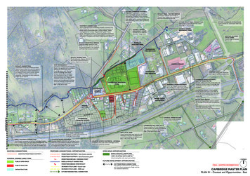
BARILLA RIVULET LINEAR PARKAcquire private land and upgrade Council landadjacent Rivulet as required to create a narrow,linear park for public use. Include seating, bikeracks, water point and bins. Park to provideadditional open space and amenity to the school,wider public and to the future Cambridge WATER RUNOFFProvide vegetated drainage swalesto treat overland flow stormwaterprior to entry into Barilla Rivulet.WAR MEMORIALLocation of new war memorialincluding memorial stones, flagpoles, pavement, seating andplanting. Installed 2015.ROUNDABOUTConsider safe pedestrian crossingand cyclist passage in roundaboutdesign. Integrate landscaping andupgrade Richmond Township arrivaland wayfinding signage.CAMBRIDGE MEMORIALOVALCAMBRIDGEPRIMARYSCHOOLCROA DOUTSHOPINSERVICESTATIONEXISTING PARKINGRetain existing parallel parkingalong Cambridge Road.Linemark for efficient use.SHOP PARKING2No. new parallel parkingspaces to front of shop.ROSELOT2aCTTOWN ENTRYRefer to Plan 04 / View 02SERVICE STATIONNew access point to service stationfrom Rose Ct via roundabout tominimise conflicting traffic flows.ANGLE PARKINGExisting angle parking to beremoved to reduce traffic conflicts.FOOTPATHProvide new footpath connectionfrom Blossom Cr to Cambridge RdSHOP PARKINGNew 90 degree parking spaces (6No.)to rear of store to be accessed off RoseCourt. Requires acquisition of north/west corner of lot.ROSE COURT - FUTURERose Court to be closed to throughvehicle traffic. Footpath to providepedestrian connection from Estate totown centre. Blossom Cr to be extended.Future Option: Lot 2a to be purchased/acquired by Council to accommodateturning circle when Rose Court is closedto through traffic.CHEVRO V ATAOLETCTDRIVEWAYSFormalise drivewaycross-overs withinstallation of newfootpath and drainageworks.IDGEAMBRCLR IV U L E TSTREET TREESPlant suitable street tree species inverge where space permits. Speciesselection to consider sight lines,maintenance, overhead powerlinesand existing residences.FOOTPATH LINKGravel footpath to connect toplaza and extend to Kennedy Driveroundabout. Currently under detailedengineering design.CAMBRIDGE HALL & LOT 53Refer to Plan 06 for Master PlanEXISTING FOOTPATHLocally widen and upgrade footpathto allow for easy movement ofpedestrians with mobility devices,prams etc.C AMR ISE DRB A R IL L ATOWN CENTRE PLAZAOpportunity to create a paved pedestrian plaza along CambridgeRoad in existing gravel parking zone. Integrate generouspavement width with parallel parking bays, street tree plantingand street furniture. Plaza provides a central point for touristparking, local and wayfinding information, community use (eg.markets) and to formalise the entry into Cambridge MemorialOval. Refer to Plan 04 for Concept Design and perspective.LEGENDEXISTING FOOTPATH - ConcretePROPOSED FOOTPATH - ConcreteM CRBLOSSOLOCAL PARK - BLOSSOM CRRefer to Plan 05 for Master PlanPEDESTRIAN CROSSING POINT / REFUGEBARILLA RIVULET SHARED TRAILPEDESTRIAN BRIDGE OVER RIVULETON ROAD CYCLE LANE - Council managed road1:1000@A2ON ROAD CYCLE LANE - DIER managed roadFUTURE PEDESTRIAN CONNECTIONCAMBRIDGE MASTER PLANPLAN 03 - Cambridge Town CentreFINAL - ADOPTED DECEMBER 2016
Retain existing trees wheresuitable and underplant withlow growing native species.Install street furniture such as seating,benches, bins and bike racks to createfunctional gathering spaces for thecommunity.War Memorial area installed bycommunity in 2015.E ROA DC AMRISC H E V ROE DRLET CTVIEW01IDGC AMBRStreet tree planting with integrated stormwatercollection and treatment system (sub-surface). Treespecies to create an informal avenue and improve theaesthetics of Cambridge Road.Informal pedestrian plaza space to consist of wide, permeableProvide pedestrian linkages throughpavement treatment allowing for parallel parking bays andto future Cambridge Footballminimum 1.5m wide footpath. Opportunity to integrate street art,Precinct and Memorial Ovallighting and wayfinding signage into footpath.TOWN CENTRE PLAZANTSINTENT: To upgrade existing gravel parking area to create a functional plaza space forcommunity and tourist use. Generous pavement widths allows for multi-use as footpath andmarket space and provides a central ‘meeting point’ for locals and tourists to Cambridge.Improves aesthetic appeal of town centre through formal street plantings and material finishes.Creates a street connection for the future Cambridge Memorial Oval upgrades.Painted on-road cycle lanes accommodated throughrelocation of Cambridge Road centre line. Retainexisting parallel parking to south side of Cambridge Road.Generous parallel parking bays accommodatebuses, motor homes and caravans creatinga central hub in the town centre for touristfacilities.Integrated WSUD swale fortreatment of stormwater runoffMinimum 1.5m wide footpath/plaza space.Street furnitureFootpath link to town centreStreet tree planting to improve streetaesthetics and reinforce the sense of a‘town centre’Town entry markersIndicative public art and signage integrated into landscapeto mark arrival into Cambridge town centre. Opportunityfor multiple or single markers incorporating public art,lighting, Council logo and signage.Street tree plantings - suite of tree species to beselected for use along Cambridge Road and localstreets. Small growing species for use under powerlines.Lot 957Retain and line mark parallel parking baysto south side of Cambridge Road.Rain garden with gap kerb edge. Stormwaterirrigates and filters through garden bed andtree pit.Formalised parallel parking bays.Painted on-road cycle lane (both sides)VIEW 01Town centre plaza - travelling east along Cambridge RoadLocation of footpath to be installed bydeveloper of Cambridge Country Estate.Painted on-road cycle lanes (both sides) requireswidening of road shoulder and adjustment of roadcentreline in some locations.VIEW 02Western town entry - travelling east on Cambridge RoadCAMBRIDGE MASTER PLANPLAN 04 - Cambridge Town Centre - Plaza and Town EntryFINAL - ADOPTED DECEMBER 2016
ADJOININGRESIDENTIALPROPERTIESSchoole RdCambridgtCseRoPark at Blossom CrescentFEATURE SHADE TREESSelectively locate large growing shade trees such asEucalyptus species to provide long term shade andscale to open space. Consider impacts on adjoiningproperties when locating.FOOTPATH CONNECTIONFootpath to link with to RoseCourt pedestrian connection whencompleted.PARK FURNITUREProvide seating at suitable locations in open space,minimum of 3 individual seats. Provide a mix of benchseats and seating with back and arm rests for elderly users.NATIVE BOUNDARY PLANTINGEstablish native gardens to perimeter of park. Utilisea mix of native shrubs, grasses and ground covers.Consider CPTED principles and impacts on adjoiningproperties when selecting planting species anddensities.rCsomBlosCamrise DrShopADJOININGRESIDENTIALPROPERTIESTOWN CENTRE CONTEXT PLANGARDEN BED EDGINGProvide garden bed edging (low profile concrete kerb)to formalise the lawn and mulched areas and to assistin easy mowing and garden bed maintenance.KICK ABOUT LAWNManaged and irrigated open lawn area for passiverecreation and ball sports.GARDEN BEDInstall and maintain garden beds with low nativeplanting to soften views into park and to frameactive playground and picnic areas.BLOSCHILDRENS PLAYGROUNDProvide play equipment for a wide range of agegroups to service the local community. Considerlarge climbing net for older children, swing set, basketswing and a toddlers combination unit. Incorporatenature play elements such as large format bouldersset out in rings or spirals beneath shade trees. Installedging to full perimeter of playground zone tocontain softfall mulch.SOMCRPICNIC SHELTERProvide 5x5m, skillion roof picnic shelter with picnic tablesetting below. Install bike racks, water bottle refill stationand rubbish bin facilities on paved hardstand. Connect picnicshelter to existing road footpath network for ease of access.Consider installation of sensor or timed lighting within shelterto satisfy CPTED principles. Picnic shelter location ensuresstrong passive surveillance from road and neighbouringproperties.ESCEDRAFT MASTER PLANMay 2015The public open space that has been contributed to Councilas part of the Cambridge residential subdivision representsapproximately 2600m2 of land. This Draft Master Plan showsthe future opportunities for the development of this land as afunctional and aesthetic parcel of open space for the Cambridgecommunity.STREET TREESInstall consistent street tree plantings along Blossom Crescent edgeof park to create a green corridor, provide shade and improve streetappeal of park.NTPARK at BLOSSOM CRESCENTExisting footpathADJOININGRESIDENTIALPROPERTIESOpen space should provide a mix of passive and active spaces aswell as park facilities such as seating, shelters and footpaths forresidents. Provision of these facilities has been balanced with easeof access and ongoing maintenance practices for Council workcrews.CASwing set with basket swingNature play elementsPicnic shelter and seatingClimbing netMERISIVDRENTSCAMBRIDGE MASTER PLANPLAN 05 - Local Park at Blossom Crescent - Master PlanFINAL - ADOPTED DECEMBER 2016
CAMEBRIDGGARDEN BEDPlant out front boundary to improve streetappeal and prevent vehicle entry.ROA DENTRY ONLYMain car park entry off Cambridge Road.NLYENTRY OPEDESTRIAN LINKSImprove pedestrian connectivity to Hallthrough improved path connections.2 PARKINGSPACESPEDESTRIAN LINKSProvide footpath connection fromCambridge Road to main Hall entry.UPGRADE PARKINGImprove layout, surfacing and line marking ofexisting car park.8 PARKINGSPACESEXISTING HEDGERemove existing hedge and replant with talltrunking trees and low growing ground coversto retain open sight lines to hall.LOW PLANTINGRemove existing planting from gardenbeds and replant with low growing, lowmaintenance species to maintain strong sightlines and visual surveillance of Hall premises.FOOTPATH LINKProvide new footpath and bollards.CAMDISABLED PARKING BAYS - 2No.Close to ramped Hall entry.RISEDRIVCHILDRENS PLAY AREAOpportunity to provide outdoor childrensplay area if required. Inclusion of sensorlighting or similar to prevent unintended useand vandalism.See Inset Plan for alternative layout of lawn areawithout play facilities.EXITEXISTING BUILDINGOpportunity to render and paint the brickextension to improve aesthetics.LOW PLANTINGMass planting to garden beds toimprove aesthetics of Hall surrounds.DRIVEWAY ENTRYExisting crossover to be two way drivewayentry to overflow car parking area.LAWN AREAProvide open, level lawn area for outdoorevents and functions at Hall.PROPOSED TREESSmall growing trees to provide shadeto car park and lawn areas.SCREEN PLANTINGInstall narrow hedge to provide vegetationscreen to adjacent property.20 PARKINGSPACESINSET PLANALTERNATIVE LAWN AREALAYOUTProvide open kick about lawnto rear of Hall. Opportunity toutilise for outdoor events andmarkets or other Hall functions.ENTRY /NOENTRYEOUTDOOR TERRACEProvide paved terrace to rear of Hall foroutdoor functions and events. Oppotunity toprovide connection from within Hall directlyonto paved area. Opportunity for pergola /roof structure over pavement and provision ofoutdoor BBQ facilities.EXISTING TREERetain and protect existing tree.DISABLED PARKING BAYS - 2No.Path connection to ramped Hall entry.LOT 53 - OVERFLOW CAR PARKOpportunity to provide overflow car parking spaceson Lot 53 with footpath connections to Hall. Provide 2disability parking bays and 18 standard bays.FENCINGSuitable fencing to define the boundarywith adjoining private property.NTSCA M BR ID G E C O M M UN IT Y HALLDRAFT MASTER PLANLOTS 989 CAMBRIDGE RD & 53 CAMRISE DRMarch 2015CAMBRIDGE MASTER PLANPLAN 06 - Cambridge Hall and Lot 53 - Master PlanFINAL - ADOPTED DECEMBER 2016
cambridge master plan plan 03 - cambridge town centre 1:1000@a2 existing footpath - concrete proposed footpath - concrete pedestrian crossing point / refuge legend barilla rivulet shared trail pedestrian bridge over rivulet on road cycle lane - council managed road on road cycle lane - dier managed road arilla rivulet future pedestrian connection