Transcription
Pedestrian planningand design guide
On 1 August 2008, Land Transport NZ andTransit NZ became the NZ Transport Agency.Any references in this document to theprevious organisations should now refer to theNZ Transport Agency.Pedestrian planning and designguideNZ Transport AgencyOctober 2009ISBN 978-0-478-35229-0 (print)ISBN 978-0-478-35228-3 (online)Copyright: October 2009 NZ Transport AgencyNational OfficeVictoria Arcade44 Victoria StreetPrivate Bag 6995Wellington 6141New ZealandT 64 4 894 5400F 64 4 894 6100
CONTENTSGlossaryINTRODUCTION1 IntroductionTHE PLANNING ANDPOLICY CONTEXT2 Planning and policy contextTHE PRINCIPLES OF PEDESTRIANNETWORK PLANNING3 Pedestrian characteristics, preferences and activity4 Community walkability5 Approaches to providing for pedestrians6 Pedestrian network componentsTHE PEDESTRIAN NETWORKPLANNING PROCESS7 Planning for pedestrians8 Pedestrian planning process9 Community involvement in scheme development10 Assessing the demand for walking11 Measuring walkability12 Prioritising schemes and measures13 ImplementationTHE DESIGN OF THEPEDESTRIAN NETWORK14 Footpaths15 Crossings16 Measures to guide pedestrians17 Lighting the pedestrian network18 Maintaining the pedestrian networkPOST-DESIGN ISSUES19 Monitoring pedestrian activity20 Making best use of facilitiesAPPENDICES1 Pedestrian characteristics2 Signface design details3 Issues to address in district plans4 References5 Index
ACKNOWLEDGEMENTSThe following consultants directly contributed to this project:Jennifer Laing of Opus, literature reviewShane Turner of Beca, project team leaderAndy Carr of Beca, then Traffic Design Group prepared the consultation draftAaron Roozenberg and Judith Goodwin of Beca, revised the draftSusan Cambridge of Francis and Cambridge, content editorFergus Tate of Opus then MWH Wellington, performed the analysis for crossing selection criteriaRodney Tolley, expert peer reviewHeather Carew, style editTim Hughes, Land Transport NZ, Christchurch, final editMegan Fowler of ViaStrada, final edits assistanceMervyn Rhind, Christchurch City Council, technical drawingSTEERING GROUPAnna Percy, AUCKLAND REGIONAL COUNCIL THEN ARTAJoe Hewitt, GREATER WELLINGTON REGIONAL COUNCILBob Alkema, LAND TRANSPORT NZJulie Chambers, SAFEKIDSBill Wrightson, DISABLED PERSONS ASSEMBLYLyndon Hammond, LAND TRANSPORT NZBruce Conaghan, MANUKAU CITY COUNCILMichael Thomson, CHRISTCHURCH CITY COUNCILCelia Wade-Brown, LIVING STREETS AOTEAROAReena Kokotailo, MINISTRY OF TRANSPORTClair Sharland, AUCKLAND CITY COUNCILRichard Lindsay, SPORT AND RECREATION NZHelen McCracken, SAFEKIDSSteve Spence, WELLINGTON CITY COUNCILIan Clark, TRANSIT NZTim Hughes (project manager), LAND TRANSPORT NZJane Mudford, LAND TRANSPORT NZVictoria Lawson, CHRISTCHURCH CITY COUNCILA special acknowledgement is owed to the late Mike Gadd, whose work on the Guide to pedestrian crossing facilities forTRAFINZ formed the basis of Chapter 15 and who urged to compilation of this more comprehensive guide.
GLOSSARY15th percentile speedElectric wheelchairLiving streetsThe speed at which, or below which, 15 percentof travellers are moving.A wheelchair powered by an electric motor thatis used by a mobility impaired person.A way to design and allocate road space to givepriority to living and community interaction.85th percentile speedFingerpost signThe speed at which, or below which, 85 percentof travellers are moving.A thin, directional sign showing the nameof, and pointing the way to walk to, a majortrip destination.Living Streets AotearoaArterial roadA main road through an area that carries trafficfrom one area or suburb to another.At-gradeWhere two or more routes meet at the samevertical level.BarrierA physical barrier to prevent vehicles that leavethe roadway from entering pedestrian areas.BenchmarkingComparing the performance of an organisation,system or network with that of others, using aset of measures (indicators) that are commonto each.FootpathThe part of road or other public place built andlaid out for pedestrian use.FrangibleDesigned to break away or deform when struckby a motor vehicle, in order to minimise injuriesto occupants.Frontage zoneCollector roadA non-arterial road that links local roads tothe arterial road network, as well as servingneighbouring property.Community walking planA road or street used mainly for accessto neighbouring properties with littlethrough traffic.A chair on wheels used by a mobility impairedperson, and propelled by the muscular energy ofthe user or pushed by another person.Grade separationA pedestrian whose ability to negotiate thewalking environment is hampered by a learningdifficulty, such as difficulty in reading signs.Local roadGISClear zoneCognitively impaired pedestrianA regional or territorial authority responsible forlocal government.MallA crossing of the kerb where the roadway andthe footpath are at the same level.An area alongside a roadway, free of potentialhazards that are not frangible or breakaway.Local authorityThe part of the footpath that pedestrians tendnot to enter, next to adjoining land or on theopposite side to the roadway.‘Geographic Information System’ – acomputerised system used for storing,retrieving, manipulating, analysing andproducing geographic data, which isreferenced by map co-ordinates.Blended crossingAn organisation that promotes walking as ahealthy, environmentally friendly and universalway of transport and recreation.The separation of pedestrians from other roadusers by a difference in heights, usually by use ofan overpass or an underpass.GradientThe slope parallel to the direction of travel.Home zoneSee Shared zone.IndicatorData collected to measure progress toward aparticular goal or objective.A walking strategic plan for improving thewalking environment specific to a definedcommunity area, that identifies the area’s issues,difficulties and proposed remedial actions.Information boardCrossfallThe slope of the footpath perpendicular to thedirection of travel.A school pedestrian crossing point that is notmarked as a pedestrian zebra crossing, at whicha school patrol operates.Crossing pointKerbAny point on the road network that hasbeen designed to assist pedestrians to crossthe he roadway and the footpath.Kerb crossingCrossing sight distanceThe distance over which pedestrians mustsee approaching traffic to be able to judgea safe gap.A place designed to facilitate convenientpedestrian access between the footpath androadway, at a kerb ramp or, if at the same level,at a blended kerb crossing.Cut-throughKerb extensionAn upright panel that lists key destinations, withdirections showing the way to walk to each one.Kea crossingSee Pedestrian precinct.Manual wheelchairMedianA continuous painted or raised strip along thecentre of the roadway.Mid-block pedestrian signalsTraffic signals that are not at intersections,that stop traffic to permit pedestrians tocross the roadway.Mobility impaired pedestrianA pedestrian whose ability to walk is hamperedby a temporary or permanent loss of ability.It includes those using mobility aids, thosecarrying difficult parcels or accompanying smallchildren, and those with temporary conditionssuch as a broken limb.Mobility scooterA powered vehicle designed for use in thepedestrian environment by a person with aphysical or neurological impairment.Mountable kerbA kerb designed to define the edge of a roadwaybut which may be mounted or driven across,if the need arises, with little risk of damage toa vehicle.Natural surveillanceThe observation of people and their surroundsby others carrying out their normal activities.New Zealand Transport Strategy n transport.A section of a traffic island or raised medianwhere the height has been reduced to thelevel of the roadway to make an area wherepedestrians can wait before crossing anotherpart of the roadway.A localised widening of the footpath at anintersection or mid-block, which extends thefootpath into and across parking lanes to theedge of the traffic lane.Desire lineOverhead clearanceA straight line between the origin and thedestination of a potential pedestrian trip.A localised area where part of the footpath islowered to the same level as the roadway next toit to facilitate convenient entry to the roadway.DownstreamKerb zonePassing placeThe direction along a roadway towards whichthe vehicle flow under consideration is moving.The part of the footpath next to the roadway.LandingA short section of widened footpath to allow onegroup of pedestrians to pass another easily.DrivewayA flat area at the top or bottom of a ramp.PedestrianA passageway across the footpath for motorvehicles, which enables drivers to access privateproperty adjacent to the road.Latent demandAny person on foot or who is using a poweredwheelchair or mobility scooter or a wheeledmeans of conveyance propelled by humanpower, other than a cycle.Kerb rampThe amount of walking that would happen ifconditions were improved, but which is nothappening currently.Older pedestrianA pedestrian who may be physically orcognitively less able than others due to aging.The height above the footpath within whichthere should be no obstructions for pedestrians.
Pedestrian advisory groupSafety auditTraffic calmingA defined group of people interested in walkingwho are consulted as a matter of course aboutrelevant issues.The process of checking a proposed design orexisting road to identify features that may resultin unsafe conditions.Changes to the road environment to reducedriver speeds.Pedestrian crossing pointSchool patrolProvision at a particular place to assistpedestrians to cross the roadway.Older children or occasionally adults that useswing signs to stop traffic and permit children tocross free of traffic conflict at pedestrian zebracrossings or kea crossings.Changes to the road environment to reduce thenumber of vehicles travelling through an area.Pedestrian fenceA fence that channels pedestrian movement. Itoffers no protection from vehicles that leave theroadway, but provides physical separation froma hazard.Pedestrian islandA raised area within the roadway that provides aplace for pedestrians to wait before crossing thenext part of the road.Pedestrian on small wheelsA pedestrian on a device with small wheelspropelled by human power, such as askateboard, inline-skates or a kick-scooter.Pedestrian permeabilityThe extent to which pedestrians can walk bydirect routes to their desired destinations.Pedestrian platformA raised area of roadway that slows traffic andassists pedestrians to cross the road.Pedestrian precinctAn area set aside for pedestrians only. Somevehicles may be permitted under specifiedconditions, such as for deliveries, or cyclistsexercising care.Personalised journey planning planA plan developed on a one-to-one basis,according to the individual’s specific travelneeds, to encourage them to use publictransport, walking and cycling.Personal securityFeeling safe from the risk of injury, attackor accident.Pram crossingSee Kerb ramp.RCASee Road controlling authority.Rest areaSchool speed zoneSpecially signed temporary speed limitscovering the school zone for the time beforeand after school.Trip walk and cycle to school and reduce the effectsof traffic near the school.The place a journey ends.School zoneArea in the vicinity of a school where crossingassistance, safety measures and parkingprovision should be considered.Segregated shared-use pathA route shared by pedestrians and cyclists whereboth groups use separate, designated areas ofthe path.Sensory-impaired pedestrianA pedestrian whose ability to walk is hamperedby the partial or full loss of a sense, mainlysight or hearing. It may include those whoare colour blind.SeveranceSeparation of people from facilities and servicesthey wish to use within their community due toobstacles to access such as busy roads.Shared zoneA residential street that has been designedto slow traffic and signed to give priority topedestrians. The shared zone sign means thattraffic is required to give way to pedestriansbut pedestrians must not unreasonablyimpede traffic.Sight distanceSee Road corridorThe distance, measured along the roadway,between a pedestrian about to enter theroadway and an approaching driver, or betweentwo drivers, or between a driver and an objecton the roadway.Thewholeoftheroadcorridorfromonefrontageto the other including footpaths. Legally roadsinclude beaches and places to which the publichave access whether as of right or not.RoadwayThe part of the road used or reasonably usableby vehicular traffic in general.Safe routes to schoolA programme that aims to improve safety andremove barriers to walking (and cycling) to andfrom school.Travel planSchool travel planRoadRoad corridorMarkings (often metal studs, coloured tilesor painted markings) set directly onto thefootpath that pedestrians follow to reachtheir hoosethe times at which it is safe for children to crossthe road.ShoulderOrganisations that are legally responsible forroads, including every city and district council,unitary authorities and Transit New Zealand.Trail signsA package of measures tailored to particularsites, such as schools or businesses, to promoteactive and environmentally friendly travelchoices and reduce reliance on the privatemotor car.School traffic wardensA flat area, part-way through a ramp orsteps, at which pedestrians can recoverfrom their exertions.Road controlling authorityTraffic reductionThe part of the road corridor outside thetraffic lanes.Street auditAn audit using a checklist to assess a street’ssafety, convenience or usability.Street furnitureEquipment within the footpath such as signalpoles, lighting columns, signs, parking meters,seats, landscaping etc.Street furniture zoneThe part of the footpath between the throughroute and kerb zone primarily used for streetfurniture.Tactile pavingA specially profiled footpath surface that can befelt underfoot. It is provided to warn or directvision impaired people.Through routeThe central part of the footpath designed as theplace where pedestrians have a continuous andaccessible path of travel.Trip originThe place a journey starts.Unsegregated shared-use pathA path shared by pedestrians and cyclists whereboth groups share the same space.UpstreamThe direction along a roadway from which thevehicle flow under consideration has come.Urban formThe overall design and structure of settlements.Vision impaired pedestrianA pedestrian whose vision is reduced t lenses, and who may use tactile, visuallycontrasting and audible cues when walking.Vulnerable pedestrianPedestrians at greater risk than others of beinginvolved in a crash, or more susceptible toserious injury. It includes older people, impairedpeople and children.WalkabilityThe extent to which the built environment iswalking friendly.WalkingThe act of self-propelling along a route, whetheron foot or on small wheels, or with aids.Walking advocateAn individual, or group of individuals,who encourage, support and enablepedestrian activity.Walking strategic planA document setting out a strategy topromote walking and provide a walkableenvironment, including a programme ofactions to achieve this.WoonerfOriginal Dutch name for a shared zone.Workplace travel planA travel plan tailored to a particular business,workplace or group of workplaces sharing acommon location, influencing travel choices ofstaff and visitors.Young pedestrianA pedestrian whose physical and cognitivedevelopment means their abilities have notreached those of normal adults.Zebra crossingA pedestrian crossing point with longitudinalmarkings, where traffic is required to give wayto pedestrians on the crossing. Legally they arecalled pedestrian crossings.
1 INTRODUCTIONINTRODUCTION TO THE PEDESTRIAN PLANNING AND DESIGN GUIDEThe purpose of this guideThe role of walkingThe guide at a glance1.1 Purpose of this guideThis guide sets out ways to improve New Zealand’s walkingenvironment. It outlines a process for deciding on the type ofprovision that should be made for pedestrians and providesdesign advice and standards.The guide promotes a consistent ‘world’s best practice’ approach to planning,designing, operating and maintaining walking infrastructure and networks. Itsupports the New Zealand Transport Strategy (NZTS) and the priorities for action inGetting there – on foot, by cycle (the national walking and cycling strategy). In doingso, it encourages walking as a viable mode of transport for short trips in and aroundour communities, and recognises the important role walking also plays in many carand public transport journeys. It is also a useful tool for those with an active interestin walking, such as community leaders, local councillors and advocacy groups.As New Zealand research into walking trips increases, the guide will be updatedand augmented.Walking mostly takes place within a transport system that must work for a rangeof road users. This requires effectively integrating walking needs for safety andconvenience into the provision for walking along and across roads. Pedestriansalso use routes outside road corridors as part of a continuous network. This guideapplies to all pedestrian infrastructure, whether it is alongside or across roads,through parks and recreational areas, or on private land where public presencemight reasonably be expected. It also applies to new developments, facility changesand existing environments.Photo 1.1 – Walking environment, AucklandA broader overview of providing for walking can be found in Easy steps published byQueensland Transport (175)Introduction1-1
1.2 BackgroundWalking is such a basic human activity that it has often been overlooked whenplanning for transport [46] and has been viewed as a second-class form of travel [103,122]. Overall, the use of walking for transport in New Zealand is declining. Taking intoaccount population growth, between 1990 and 1998 journeys made solely on foot inNew Zealand reduced by around 400,000 per day [112].Even so, walking remains a key element of a balanced transportation system. Overall,it is still the second most popular form of travel in New Zealand. Nearly one in five ofall household trips is made on foot [112]. For the 10 percent of households that have nocar, for those in households without car access for much of the day, and for those whocannot, or choose not to drive, walking is an especially vital mode of transport [112].Photo 1.2 – Pedestrians, ChristchurchWalking is also included in most trips made by other modes. Whatever themain means of travel, walking is usually the first and last mode used, providingan important link between land use and motorised travel [118]. It is also healthy,inexpensive and very environmentally friendly. Although much of the guidefocuses on walking for transport, people walk for pleasure on all types ofinfrastructure. The attractiveness and quality of our streets and public spaces is,therefore, key to getting more people to walk [59].The approaches to providing for pedestrians and the interventions adopted willdepend on the circumstances at each location. With this in mind, the guide does notprescribe a single approach or intervention, but presents a variety, along with circumstanceswheneachwouldbe most appropriate. It recognises that financial, technical and political factors mayaffect what can be achieved at any particular location or time.1.3 MethodologyThe project to develop this guide was managed by Land Transport New Zealand(LandTransport NZ) as one of the Road Safety to 2010 strategy projects. Consultantswere employed to develop the drafts and a stakeholder steering group guided itsdevelopment and gave feedback on the drafts.The content was guided by a review of international literature on providing andplanning for pedestrian facilities and networks. A draft was released for publicsubmissions and, after the final draft was received from the consultants, aninternational peer review was conducted. LandTransport NZ then undertook somefinal edits.1.4 Guide and process outlineFigure 1.1 provides an outline of the sections in this guide.1-2Introduction
CONTEXTPlanning and policy context (Ch.2)What is the environment for planning for pedestrians?APPENDICESPRINCIPLESPedestrian characteristics, preferences and activity (Ch.3)How do pedestrians differ, and who walks, where and why?Appendix 1Characteristics of pedestriansCommunity walkability (Ch.4)What makes walking attractive within communities?Approaches to providing for pedestrians (Ch.5)What are the underlying ways to accommodate walking?Pedestrian network components (Ch.6)What type of facility can be used to provide for pedestrians?PROCESSPlanning for pedestrians (Ch.7)Which planning approach should be used?Communityinvolvementin schemedevelopment(Ch.9)Does thewalkingenvironmentmeet the needsof pedestrians?Pedestrian planning process (Ch.8)How do we implement the plan?Appendix 2Signface design detailsAssessing demand for walking (Ch.10)How many pedestrians want to walk and where?Measuring walkability (Ch.11)How is walkability assessed?Prioritising schemes (Ch.12)Which walking schemes should be done first?Implementation (Ch.13)How should the walking schemes be implemented?DESIGNFootpaths (Ch.14)How do pedestrians move around?Crossings (Ch.15)How do pedestrians cross major obstructions?Measures to guide pedestrians (Ch.16)How are pedestrians guided to their desired destination?Lighting the pedestrian network (Ch.17)How is the pedestrian network illuminated?Appendix 3Issues to address in district plansMaintaining the pedestrian network (Ch.18)How are pedestrian facilities kept in good order?Appendix 4ReferencesAppendix 5IndexPOST-DESIGNMonitoring pedestrian activity (Ch.19)Do walking schemes achieve their objectives?Making best use of facilities (Ch.20)How can people be encouraged to walk?Figure 1.1 – Guide outline and processIntroduction1-3
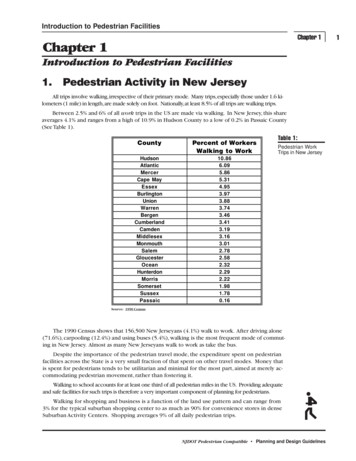
2 THE PLANNING ANDPOLICY CONTEXTPEDESTRIAN PLANNING AND POLICY CONTEXTThe legal framework for providing walking infrastructureThe role of walking in government objectives and strategiesWalking strategic plans2.1 IntroductionWalking is a form of transport, and in this respect is no different from the private car or publictransport. For some groups, it is the primary means of moving around their communityindependently [30]. The right to walk is a fundamental element in a considerable number ofpublic policies. Although its contribution to transport objectives is often underestimated, itsimportance must not be ignored [10].2.2 Transport and the law‘Legislation’ includes Acts of Parliament, as well as Rules and Regulations made by peopleor organisations to whom Parliament has delegated this power (for example, the Ministerof Transport for Land Transport Rules). The main pieces of legislation relating to walkingare the Local Government Act 2002, the Traffic Control Devices Rule 2004 [111] and theLand Transport (Road User) Rule 2004 [110] where pedestrians are specifically differentiatedfrom ‘vehicle traffic’. There are also relevant Rules on the use of land (under the ResourceManagement Act 1991) in regional and district plans.‘Law’ includes not only ‘legislation’, but also common law, which is understood andaccepted by everyone and defined by law court judgments. Common law includeseveryone’s duty to care for their own safety and to avoid causing harm to others.Under common law, everyone has the right to travel unimpeded on all public roads, exceptwhere there are legal restrictions (such as those prohibiting pedestrians from motorways).Road controlling authorities (RCAs) are obliged to safeguard this right for all lawful roadusers, including pedestrians. The Local Government Act requires that wheelchair accessiblekerb crossings be provided whenever any urban road or footpath is being reconstructed.2.3 Bylaw powersLocal authorities and RCAs also have the power to enact bylaws for areas within theirresponsibility. Bylaws can cover activities both on footpaths beside roads and on off-roadpaths such as through parks. They can also be used for activities on the road that may affectpedestrian safety or mobility, for example vehicle speed limits and parking.2.4 New Zealand Transport StrategyThe New Zealand Transport Strategy (NZTS) [108] contains the government’s position ontransport. Its overall vision is: ‘by 2010, New Zealand will have an affordable, integrated,safe, responsive and sustainable transport system’. Broader objectives aim to enhanceeconomic, social and environmental well-being through: improving access and mobility, including walking and cyclingprotecting and promoting public healthensuring environmental sustainabilityassisting safety and personal securityassisting economic development.Key principles include: creating an integrated mix of transport modestaking a long-term sustainable approachensuring high standards of health, safety and securityresponding to the diverse needs of transport users.The planning and policy context2 11
Figure 2.1 – Summary of the vision, priorities, goals, and key principles of Getting there – on foot, by cycle, the national walking and cycling strategy2 2The planning and policy context
2.5 Integrated transport planningIntegrated transport planning aims to embrace a range of perspectives traditionallyaddressed separately, including: a variety of forms of transport (private and public, motorised and non-motorised) the relationships between transport and land use transport’s contribution to other economic, social, health andenvironmental objectives.Integrated transport planning is embodied in Land Transport NZ’s objective, whichis to allocate resources in a way that contributes to an integrated, safe, responsiveand sustainable land transport system [109]. When allocating funds, Land TransportNZ must consider a range of issues including environmental sustainability and publichealth. Transit New Zealand (Transit NZ), as the RCA for state highways, is to operatethe state highway system in a way that contributes to such a system. Walking is anessential part of an integrated transport plan and is an integral part of achieving thegovernment’s vision for land transport. As a result, Land Transport NZ invests in arange of walking and cycling activities, such as providing financial help to RCAs forstrategic plans and walking (and cycling) projects.2.6 National walking and cycling strategyThe national walking and cycling strategy [112] Getting there – on foot, by cycle expandson the aims of the NZTS. It articulates a vision, goals, priorities and principles asoutlined in Figure 2.1. This is accompanied by an implementation plan [178] that setsout a method for achieving the strategy.2.7 Regional land transport strategiesEach regional council is required to develop a regional land transport strategy (RLTS)with help from a regional land transport committee (RLTC). RLTCs are legally requiredto represent a range of transport perspectives, including walking. Although regionalcouncils do not directly manage the roads, all projects and strategies in their regionsmust take the RLTS into account, and regional councils may play a variety of roles withregard to walking, such as strategic planning, coordinating schemes and promotingwalking. RLTSs also carry weight in Land Transport NZ’s decisions on funding RCAprojects and packages. They need to be consistent with the NZTS and should reflectthe priorities for action in Getting there – on foot, by cycle.2.8 Road controlling authoritiesAs well as being a local authority, every city and district council is an RCA. WhileTransit NZ is the RCA for state highways, some local authorities manage theirarea state highways on its behalf. Organisations such as airport companies, portcompanies and the Department of Conservation are also RCAs.RCAs have direct responsibility for the road system. They usually own the roads andpublic paths, and (often through contractors) build, improve and maintain them. RCAshave powers to regulate road user behaviour, such as by banning parking, creatingone-way streets and installing traffic signals.RCAs are also required by Land Transport NZ to produce strategic plans detailingthe projects and packages they intend to carry out. These will contain projects thatencourage more people to walk or cycle (see section 2.11).2.9 Other local council responsibilitiesLocal councils have other roles, besides that of RCA, that affect walking – they controlthe planning, design and maintenance of parks and reserves, and produce district orcity plans under the Resource Management Act 1991 that provide a framework formanaging land use and subdivision within the area. The relevant regional and localstrategies and plans in relation to walking are:Regional: regional land transport strategyregional walking strategyregional road safety planregional growth strategyThe planning and policy context2 33
regional policy statement regional travel demand management strategy (under the regionalland transport strategy).Local: local transport strategieslocal walking strategic plansneighbourhood accessibility plansroad safety strategies and planssafety management systemsdistrict and city planslong-term council community plansasset management planscodes of practicedesign guidesopen space access planstravel demand management strategies.2.10 Other non-transportgovernment strategiesWalking plays a role in supporting a wide range of other activity. Actions to providefor or promote walking should take account of, and coordinate with, other nontransport strategies and policies for [30, 103, 130]: healthtourismheritageenvironmental protectionurban design and formplanning and developmentregenerationsocial inclusionrecreatio
A school pedestrian crossing point that is not marked as a pedestrian zebra crossing, at which a school patrol operates. . Living streets A way to design and allocate road space to give priority to living and community interaction. Living Streets Aotearoa An organisation that promotes walking as a