Transcription
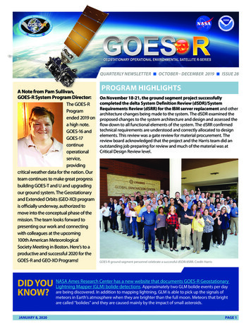
GOES-R Series Program quarterly newsletter, Issue 28, covering the time October through December 2019.QUARTERLY NEWSLETTER n OCTOBER– DECEMBER 2019 n ISSUE 28A Note from Pam Sullivan,GOES-R System Program Director:The GOES-RProgramended 2019 ona high note.GOES-16 ical weather data for the nation. Ourteam continues to make great progressbuilding GOES-T and U and upgradingour ground system. The Geostationaryand Extended Orbits (GEO-XO) programis officially underway, authorized tomove into the conceptual phase of themission. The team looks forward topresenting our work and connectingwith colleagues at the upcoming100th American MeteorologicalSociety Meeting in Boston. Here’s to aproductive and successful 2020 for theGOES-R and GEO-XO Programs!PROGRAM HIGHLIGHTSOn November 18-21, the ground segment project successfullycompleted the delta System Definition Review (dSDR)/SystemRequirements Review (dSRR) for the IBM server replacement and otherarchitecture changes being made to the system. The dSDR examined theproposed changes to the system architecture and design and assessed theflow down to all functional elements of the system. The dSRR confirmedtechnical requirements are understood and correctly allocated to designelements. This review was a gate review for material procurement. Thereview board acknowledged that the project and the Harris team did anoutstanding job preparing for review and much of the material was atCritical Design Review level.GOES-R ground segment personnel celebrate a successful dSDR/dSRR. Credit: HarrisAmes Research Center has a new website that documents GOES-R GeostationaryDID YOU NASALightning Mapper (GLM) bolide detections. Approximately two GLM bolide events per daybeing discovered. In addition to mapping lightning, GLM is able to pick up the signals ofKNOW? aremeteors in Earth’s atmosphere when they are brighter than the full moon. Meteors that brightare called “bolides” and they are caused mainly by the impact of small asteroids.JANUARY 8, 2020PAGE 1
PROGRAM HIGHLIGHTS (CONTINUED)On December 9, GOES-16 space weather data from theSolar Ultraviolet Imager (SUVI), Extreme Ultravioletand X-ray Irradiance Sensors (EXIS), Space EnvironmentIn-Situ Suite (SEISS), and Magnetometer (MAG) becameoperationally available from NOAA’s Space WeatherPrediction Center (SWPC). GOES-16, which offers a numberof improvements to space weather data, is now the primarysatellite for geostationary space weather observations.performance. Two GMAGs are currently in long-termstability testing at the NASA Goddard magnetic test site.A new GOES-R 3D model was completed in December.The interactive model allows users to rotate the spacecraft,zoom in and out, and explore the components of thesatellite. The mobile version has an augmented realitycapability that allows users to superimpose the satellite onthe scene in their device’s camera.GOES-16 SUVI image from December 10. Credit: NOAA SWPCA two-phase test was conducted in October toinvestigate whether modifying the GOES-17 AdvancedBaseline Imager (ABI) scan pattern during periodsof high thermal loading would decrease the numberof saturated images due to the loop heat pipe (LHP)anomaly. Preliminary results from scan pattern testsindicate that scanning only one full disk every 30 minutesdrops LHP temperature by 7 Kelvin, resulting in about twoextra hours of unsaturated water vapor imagery. L3Harrisis running thermal models to project these results to otherpossible scanning strategies. Results were provided tothe National Weather Service (NWS), which is assessingwhether any of these scanning mode alternatives aredesirable. Additional cooling timeline tests will beconducted before a final decision is made.The GOES-T and GOES-U satellites will fly NASAGoddard Magnetometer (GMAG) instruments,instead of the Macintyre Electronic Design AssociatesMagnetometers that fly on GOES-16 and GOES-17. Thechange is being implemented to improve instrumentJANUARY 8, 2020A GOES-R satellite “visited” the GOES-R Program Office at NASA Goddard SpaceFlight Center via augmented reality. Credit: GOES-R ProgramOn December 18, NOAA officials announced plans topower off the GOES-15 satellite and place it into orbitalstorage by January 31, 2020. Since late 2018, GOES-15 hasoperated in tandem with GOES-17, as a precaution, whileengineers worked on technical issues with the ABI LHPs.NOAA also announced GOES-14, which has been providingsupplemental space weather instrument operations, will bepowered off and placed in storage by January 31. GOES-16,in the GOES East position, is sending more advanced spaceweather data to NOAA’s SWPC. Additionally, GOES-17 isPAGE 2
PROGRAM HIGHLIGHTS (CONTINUED)providing products in a developmental system for spaceweather. GOES-15 and GOES-14 can be called back intoservice if either GOES-17 or GOES-16 experience issues.In December, NASA selected United Launch ServicesLLC (ULS) to provide launch services for GOES-T, thethird satellite in the GOES-R Series. GOES-T is currentlytargeted to launch in December 2021 on an Atlas V 541rocket from Launch Complex 41 at Cape Canaveral AirForce Station in Florida. NASA’s Launch Services Programat Kennedy Space Center in Florida will manage the ULSlaunch service.GEO-XOPlanning for next-generation NOAA satellite systemsis underway. In the geostationary domain, NOAA ispreparing for the Geostationary and Extended Orbits (GEOXO) program, so named because it is envisioned to employsensors and spacecraft in geostationary orbit and also inSun-Earth Lagrange Point orbits as successors to the DeepSpace Climate Observatory (DSCOVR) and Space WeatherFollow-On (SWFO) missions. GEO-XO may also include neworbits, instruments, and space architecture. The GEO-XOoperational phase is planned for the 2030-2050 timeframe.On October 3, NESDIS released a pair of Broad AgencyAnnouncements (BAAs) to engage the commercialsector in developing new concepts for instruments,spacecraft, business models and mission elements forNOAA’s future space-based observation architecturebeyond the JPSS and GOES-R systems. Interestedparties gathered more information at Industry Day eventsOctober 17-18. The GEO-XO BAA sought white papers thatwill lead to funded concept studies of instrument andarchitecture concepts for remote sensing capabilities ingeostationary and extended orbits. The GEO integratedprogram team reviewed the BAA responses and providedrecommendations to the management review team onwhich studies to fund.On December 18, the GEO-XO pre-formulation teampresented the GEO-XO program for Milestone Zero(M0) for approval. The presentation highlighted thenecessity of the GEO-XO program to maintain continuityof critical terrestrial and space weather data collectedcurrently by the GOES-R system and in the future by theSpace Weather Follow On mission. The team presented athorough plan for the GEO-XO program definition activities,including a road map of major activities and decisions,governance structure, planned partnerships, and plans foruser engagement. The NESDIS Assistant Administrator, asthe Milestone Decision Authority, approved the GEO-XOM0 and its entrance to the conceptual phase (Milestone 1).This phase is planned to last approximately one year andculminate in a Mission Concept Review and Milestone 1 keydecision point in late 2020.SCIENCE APPLICATIONSWith the advent of the GOES-RSeries, forecasters now havean overwhelming amount ofinformation to sift through. To helpmeteorologists quickly discern theinformation they need to issue timelyforecasts and warnings, scientists areworking on new ways to combineinformation from multiple ABI channelsto enhance features of interest. Theresult is a variety of red-green-blueor “RGB” composite imagery. Thestunning, colorful imagery you seefrom GOES-16 and GOES-17 isn’t justbeautiful to look at, it also providescritical information to forecasters forsituational awareness and nowcastingrapidly changing weather.JANUARY 8, 2020This GOES-17 air mass RGB imagery shows a hurricane-force low (the remnants of Super Typhoon Hagibis)over the Bering Sea and a storm-force low over the Gulf of Alaska. This type of imagery combines water vaporand infrared imagery from the ABI and is used to monitor the evolution of cyclones and jet streaks. Credit:NOAA/CIRAPAGE 3
SCIENCE APPLICATIONS (CONTINUED)The GOES-R Series Geostationary Lightning Mapper (GLM)is the first instrument of its kind in geostationary orbit. Itdetects total lightning (in-cloud and cloud-to-ground) activityand reveals the spatial extent and distance lightning flashestravel. Rapid increases in total lightning activity often precedesevere and tornadic thunderstorms and can be an indicationthat a hurricane is strengthening. This new infographic explainshow GLM data is critical not only for a number of public safetyapplications but also for understanding and predicting longterm changes in climate.Wind is afundamentalvariable ofweather.The heatingof Earth’ssurface andatmosphereby the sundrives windsthat move heatand moisturefrom one placeto another.Variations inlarge-scaleGOES-16 winds generated over Hurricane Irma onwind circulation September 6, 2017, overlaid on GOES-16 visibleimagery. Credit: NOAApatterns areresponsible for the daily weather we experience.Satellite wind estimates help forecasters understandcurrent weather conditions and contribute importantinformation to global weather prediction models.Satellites like GOES-16 and GOES-17 provide more andbetter estimates of winds for improved forecastingtools and a better understanding of severe weather.A new machinelearning algorithmuses SUVI data tofind solar flares andother events in vaststreams of solarimages and help NOAAforecasters issuetimely space weatheralerts. This technique,developed by scientistsat the National Centersfor EnvironmentalInformation (NCEI)The SUVI thematic map (right) produced by the new algorithm tracks changes in the sun (left) over time. Credit: Dan Seaton andJ. Marcus Hughes, NCEI/CIRES/CU Boulderand the CooperativeInstitute for Researchin Environmental Sciences (CIRES), searches massive amounts of satellite data to pick out features significant forspace weather. Changing conditions on the sun and in space can affect various technologies on Earth, blocking radiocommunications, damaging power grids, and diminishing navigation system accuracy. SUVI data is being used to generatesolar thematic maps that will serve as the basis for a variety of new space weather products from NOAA’s SWPC. In thethematic maps, different colors correspond to different themes: yellow corresponds to active regions while dark blueshows quiet solar regions.JANUARY 8, 2020PAGE 4
DATA AND IMAGERYGOES-16 captured two large storm systems over theUnited States on October 11. To the west, a powerfulcold front pushed eastward into the Plains and theMidwest. This moved into a much warmer, more humidair mass to the east, causing a massive line of fast-movingthunderstorms to form along the sharp temperaturegradient. Off the East Coast, a former nor’easter centeredsoutheast of New England became Subtropical StormMelissa. It brought rain and some wind to coastal areas ofMassachusetts.GOES-16 captured two large storm systems over North America on October 11. Credit NOAAA fast-moving wildfire,driven by strong winds,ignited on October23 in Sonoma CountyCalifornia. At 9:21:01p.m. PDT, the GOES17 mesoscale sectorpositioned over Californiafirst detected heat inABI bands 5, 6, and 7,indicating a potentialfire. The fire intensifiedGOES-17 hot spot, smoke, and burn scar RGB imagery of theKincade Fire on October 27. Credit: NOAA/Satellite Liaisonrapidly and the GOES-RBlogfire detection andcharacterization product picked up the fire. Initial reports from theCalifornia Department of Forestry and Fire Protection put the ignitiontime at 9:26 PDT. GOES-17 captured hot spot, smoke, and burn scar RGBimagery of the Kincade Fire on October 27. This type of imagery allowsforecasters to see a fire’s hot spots, smoke, and burn scar in one image.Hot spots (active wildfire) appear as red, the smoke plume as faded blueor cyan, clouds a bright cyan, and burned area as locally dark. Highlyvegetated areas appear as bright green and bodies of water very dark.The active large fire is readily apparent, with the associated burn scarextending north of the ongoing fire. The smoke plume extends well tothe southwest of the fire.JANUARY 8, 2020On November 11, the planet Mercurypassed directly between the sun and Earthand the GOES-16 SUVI tracked the transit. Theevent lasted for approximately five and a halfhours, from 7:35 a.m. to 1:04 p.m. EST. Duringthe transit, Mercury appeared as a tiny blck dotmoving across the sun. Transits of Mercury onlyhappen about 13 times per century – the nexttransit will be in 2032 and the next opportunityto catch a Mercury transit in the U.S. will be in2049.GOES-16 SUVI image of the Mercury transit at 8:00 a.m. EST onNovember 11, near the beginning of the transit. Credit: NOAAPAGE 5
DATA AND IMAGERY (CONTINUED)GOES-17 monitored a mid-latitudecyclone swirling in the Gulf of Alaskaon November 12. These tend to formwithin the Aleutian Low, which is asemi-permanent breeding groundfor some of the strongest stormson Earth. Located near the AleutianIslands of Alaska, the Aleutian Lowhelps encourage storm developmentdue to a combination of considerabletemperature differences, a strongCoriolis force, and a high latitudelocation. This storm system steadilycrept northward, bringing rain to thesouthwestern region of Alaska, acrossthe Gulf Coast, as well as into thesoutheast.GOES-17 imagery of the mid-latitude cyclone in the Gulf of Alaska on November 12. Credit: NOAACONFERENCES AND EVENTSA RELAMPAGO (Remote sensing of Electrification, Lightning, AndMesoscale/microscale Processes with Adaptive Ground Observations,translates to lightning flash in Spanish and Portuguese)/CACTI (Clouds,Aerosols, and Complex Terrain Interactions) Data Analysis Workshopwas held in Buenos Aires, Argentina, November 19-22. This meeting broughtresearchers and students together to highlight available data, analyze dataquality, present first research results, and forge research collaborations. TheRELAMPAGO campaign is a high-impact weather project endorsed by theWorld Meteorological Organization (WMO) World Weather Research Programwith international participation of scientists supported in the U.S. by NOAA,NASA, the Department of Energy, and the National Science Foundation. TheRELAMPAGO campaign began in June 2018 and extended through April 2019.United States Ambassador to Argentina Edward C. PradoDuring the campaign, GOES-16 data collection supported the experiment(left) and RELAMPAGO co-leads Professor Paola Salio,research objectives and also provided additional post-launch data validation.University of Buenos Aires (center) and Professor SteveNesbitt, University of Illinois (right) during a receptionSpecial GOES-16 mesoscale domain requests collected more than 470 hoursat Bosch Palace, the ambassador’s residence. Credit: U.S.of one-minute imagery over a 30-day period. As part of the workshop, aEmbassy, Republic of Argentinashort course “Using GOES 16 to nowcast convection over South America” wasconducted on November 22. This course provided information about the ABI and GLM sensors as well as multiple tools andproducts for analyzing and nowcasting storms in South America.The American Geophysical Union (AGU)Annual Fall Meeting was held December 9-13in San Francisco. There were several GOES-Rpresentations in two sessions on remote sensingof land, ocean, and atmosphere from the newgeneration of geostationary satellites. Thesesessions highlighted new data sets, algorithms,and computational platforms that utilize datafrom the latest generation of geostationarysatellites. The GOES-R program also supportedthe NOAA exhibit at the conference with handoutmaterials and live presentations at the booth.JANUARY 8, 2020GOES-R senior scientific advisor Dan Lindsey shows off GOES-R capabilities to visitors of the NOAAbooth at the AGU conference. Credit: NOAAPAGE 6
ACCOLADES AND AWARDS2019 Administrator’s Award recipients, including GOES-R’s Kathryn Mozer (nowwith NOAA’s Office of Oceanic and Atmospheric Research) and Elizabeth Kline, whowere honored for innovation and collaborative problem-solving to establish NWS’operational readiness for new weather-satellite data products. Credit: NOAASeveral GOES-R team members were recipients of theNOAA Administrator’s Award in November. Pam Sullivanand Dan Lindsey were part of a team recognized for theextraordinary effort to recover the capability of the GOES17 ABI for our nation’s weather forecasting needs. A teamincluding Matthew Seybold, Kathryn Mozer, and ElizabethKline was recognized for innovation and collaborativeproblem solving to establish the National Weather Service’soperational readiness for new weather satellite dataproducts. The NOAA Administrator’s Award recognizesemployees who have demonstrated exceptional leadership,skill, and ingenuity in their significant, unique, and originalcontributions to NOAA, the Department of Commerce, andthe Federal Government. Recipients were honored at aceremony on November 21.Matt Ikemeier received the NESDIS OutstandingInformation Technology and Engineering Employeeof the Year award in December. Matt was recognized for developing effective operational efficiency tools for the GOES-Rproduct generation and distribution systems.MEET THE TEAMIn this issue, meet Audrey Hogg, NOAA Contracting Officer for the GOES-RSeries ground segment contract with Harris Corporation. Audrey, an acquisitionprofessional with more than nine years of federal contracting experience and 20 yearsof private sector experience in multiple disciplines, joined the program in November.Prior to joining NOAA, she served as a member of the U.S. Navy’s Strategic SystemsProgram high-level contracts team for the nation’s multibillion-dollar submarinelaunched Trident II D5 fleet ballistic missile program.To achieve agency goals while saving the government money, Audrey stresses theimportance of effective communication and innovative problem-solving skills. Thesequalities help her exceed established milestones and complete all assignments aheadof schedule and within or below budget. Audrey has received several awards duringher career, including a monetary award from the Department of the Navy for herdistinguished accomplishments as a part of Fiscal Year 2020 TRIDENT II Tri-Party Negotiation Team.Audrey holds a Bachelor of Science degree in computer science from California State University, and a master’s degreein telecommunications management from Golden Gate University. She is also one of a few elite graduates of the NavalAcquisition Associates Program and a Certified Federal Contract Manager (CFCM) by the National Contract ManagementAssociation (NCMA). Outside of work, Audrey enjoys travel, church missions, and reading. She is originally from the samehome country as the fastest man in the world and the most recent Miss Universe. “Yes, man, Irie”!UPCOMING EVENTSAmerican Meteorological Society100th Annual MeetingJanuary 12-16, 2020Boston, MAGOES-R/JPSS Proving Ground/RiskReduction SummitFebruary 24-28, 2020College Park, MD36th Space SymposiumMarch 30 – April 2, 2020Colorado Springs, COCONNECT WITH US!JANUARYOCTOBER 8,9 ,20202019PAGEPAGE 77
storage by January 31, 2020. Since late 2018, GOES-15 has operated in tandem with GOES-17, as a precaution, while engineers worked on technical issues with the ABI LHPs. NOAA also announced GOES-14, which has been providing supplemental space weather instrument operations, will be powered off and placed in storage by January 31. GOES-16,