Transcription
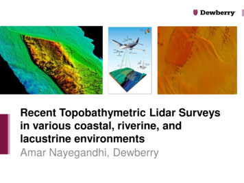
Recent Topobathymetric Lidar Surveysin various coastal, riverine, andlacustrine environmentsAmar Nayegandhi, Dewberry
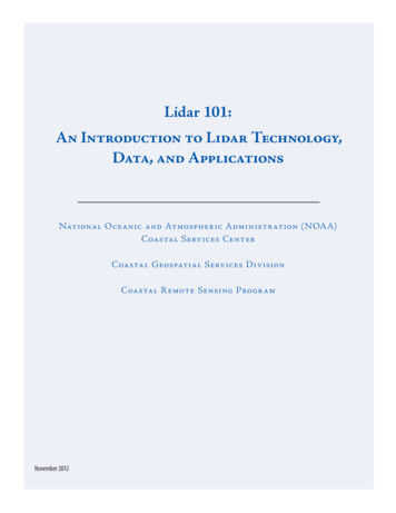
Airborne topobathymetric LiDAR Airborne remote sensing technique usedto measure the height of the surface onland and underlying streams, rivers, lakes,bays, and shallow coastal waters inmoderately clear water column conditions. The depth range of bathy LiDAR systemsis primarily limited by water clarity (turbidity) bottom reflectivity type of LiDAR system being used. Current bathy and topobathy LiDARsystems have depth performance of 1 to 3times the Secchi depth.
Why topobathy LiDAR? Complements acoustic (multi-beam sonar)technology Airborne topobathy LiDAR is of high value infilling the “0 to 10 m” depth gap in coastal andriverine areas Rapid survey of shallow water areas that aredifficult, dangerous, or impossible to get usingwater borne methods Ability to rapidly assess riverine and estuaryenvironments: channel cross sections,biological habitat, riparian conditionsImage courtesy Watershed Sciences, Inc.
Seamless topobathy DEM
Bathymetric vs. Topobathymetric Lidar5
Airborne LiDAR Bathymetric Systems Traditional bathymetric systems SHOALS / CHARTS (Optech) LADS (Fugro LADS) HawkEye III (AHAB) CZMIL (Optech) Commercial topobathymetricsystems Riegl VQ-820G/880G Optech Titan Leica-AHAB Chiroptera CZMIL (Optech)*Not an exhaustive list
Dewberry’s SensorSelection CriteriaBeaver Islands, Chiroptera IIPuerto RicoRiegl Topo sensors;Riegl VQ820G/880GAucilla Bay, FL, VQ 880GChandeleursChiroptera IIKings BayCZMILEverglades NP,Titan and Riegl VQ880G Dewberry selects/recommendstopobathy sensor technology based on a“horses for courses” approach. Sensor selection is based on projectrequirements, intended application, cost,and client recommendation. Sensor agnostic / vendor neutralapproach Work with sensor manufacturers, dataacquisition partners, and client to acquiredata. Dewberry will work with governmentagencies who own topobathy lidarsensors to help process data from thesesensors. Will lease sensor/aircraft or subcontractas needed.FL KeysChiroptera II
Recent Topobathy Projects by DewberryClientProject LocationSensor UsedData AcquisitionApplicationSWFWMDKings Bay / ThreeSisters Springs, FLOptech CZMILApril 2015Florida Springs Initiative – protect andpreserve natural springsNOAA Office forCoastal ManagementBeaver IslandsArchipelago and SouthManitou Island, UpperLake MichiganAHAB Chiroptera IINovember 2015,completed May 2016Sea Level RiseUSGS & NOAA NGSPuerto RicoTopography andTopobathyRiegl Q780iRiegl Q680iRiegl VQ820G2014/15 (bathy)Jan – May 2016; Dec– Feb 2017 (topo) –96% completeMapping the entire island, includingsurrounding islands, for USGS 3DEPprogram.NOAA NGSPuerto RicoRiegl VQ880GWinter 2015/16NGS Shoreline Mapping ProgramUSGS / NPSEverglades NP PilotRiegl VQ880GOptech TitanApril / May 2016Pilot study to determine the mostappropriate sensor technology to usefor mapping the EvergladesFlorida DEP, AucillaResearch InstituteAucilla and EcofinaBay/RiverRiegl VQ880GJuly 2016Delineation of submerged riverchannelsUSGSChandeleur Islands,Gulf of MexicoAHAB Chiroptera IIJune 2016USGS Coastal Program researchUSGSNorthern FL Reef TractAHAB Chiroptera IIJune 2016USGS Coastal Program researchUSGS & NOAA (andUSACE)West coast El NinoprojectTopo sensor –helicopter basedApril-May 2016Impact of El Nino to beach and clifferosion along the US west coastNOAA NGSMartha’s Vineyard andNantucketAHAB Chrioptera IIOct – Nov 2017NOAA’s shoreline mapping program
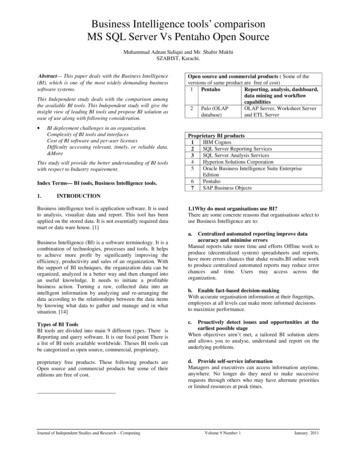
An Application for Topo-Bathymetric LiDARon the Springs Coast of FloridaAlvan Karlin, Ph.D., CMS, GISPSouthwest Florida Water Management DistrictandAmar Nayegandhi, CP, CMS, GISPDewberry
IntroductionBecause soluble limestone of the upper Floridan Aquifer occur close to the surfaceand are not covered by confining sands, the northern portion of the SWFWMDhas developed into a karst landscape, characterized by sink holes, sinking streams,underground caverns, and springs,The King’s Bay Springs (aka Crystal River Springs) group is the second largest springssystem in Florida and composed of numerous springs distributed over a large area;the largest are: Black, Tarpon Hole, Idiots Delight, and Hunter’s Springs,The King’s Bay Springs discharge approximately 567 MGD into King’s Bay, the headwatersof the Crystal River,Groundwater discharging at the King’s Bay Springs may be fresh (primarily on the easternside) or brackish (primarily on the western side), depending on tides and water levelsin the Floridan aquifer,Material, both organic and inorganic, tends to accumulate in the underwater Karst terrain.
King’s Bay, Citrus County, FLNear Hunter’s Spring (Winter 2015)137 Manatees
King’s Bay Springs Complex, Citrus County, FL
Teledyne/OptechCoastal Zone Mapping and Imaging LiDARImages care of JALBTCX and Teledyne/Optech)
Why CZMIL Sensor for this study?DeepChannelonlyAllChannels(Deep Shallow)ShallowChannelsonlyDeep Shallow channels used tocreate bathymetric model
Seamless Topobathymetric Digital Elevation Model(Hard Bottom)CatfishSpringHunter’sSpring
Hunter’s Spring
Catfish Spring
Why LiDAR? Oops Sonar missed Hunter’s Spring!
Everglades National Park LiDAR ProjectNational Park LiDAR Pilot 2016
FL Everglades NP LiDAR Pilot 2016USGS – NPS funding Partnership for lidar collection coveringEverglades National park.USGS asked Dewberry to fly lidar for the project.Dewberry proposed a Pilot Study. Lidar sensors vary in their ability to collect data over acombination of dry land, wetland and open water. Due to the unique nature of the Everglades landscape, wewanted to test lidar sensor technology prior to fullimplementation of lidar collection for a large area of EvergladesNP.Elevation data resulting from lidar collection and processing will beused to support several scientific studies underway including astudy to model marl prairie habitat for the Cape Sable SeasideSparrow, an endangered non-migratory song bird residing solely inthe Everglades.Cape Sable Seaside Sparrow
Everglades NP LiDAR Pilot 2016Coordination with NPS to determine a suitable footprint for the pilot project. 33 Square MilesPilot Boundary
Everglades NP LiDAR Pilot 2016TWO INDEPENDENT LIDAR ACQUISITIONS WERE COMPLETEDLidar acquired by NOAA NGS on May 5, 2016.Riegl VQ-880-G lidar sensor Combined Topo-Bathymetric airborne laserscanning system Full waveform sensor Narrow-beam green laser Integrated infrared laser Altitude 400 m AGL
Everglades NP LiDAR Pilot 2016TWO INDEPENDENT LIDAR ACQUISITIONS WERE COMPLETEDLidar acquired June 15 -17, 2016.Teledyne Optech Titan lidar sensor Combined Topo-Bathymetric airborne laserscanning system Three independent channels – one for eachwavelength. 532nm –visible (green)1064nm -NIR1550nm -IR Altitude 1: 400 m AGL Altitude 2: 1000 m AGL
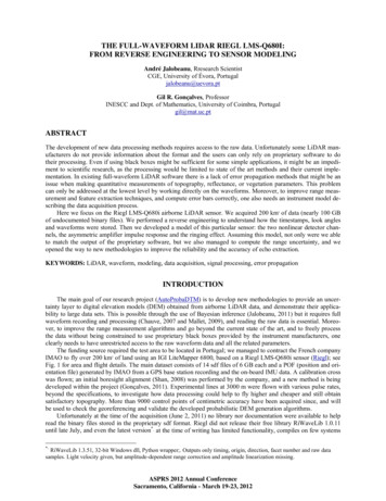
Pilot Acquisition and Analysis – Testing to Model Different HabitatsMAP LEGENDRED: Project Boundary Riegl and Titan LiDAR acquired at 400m AGLYELLOW: Titan high-altitude LiDARacquired at 1000 m AGLBLUE: Pilot project tile gridORANGE:4 areas selected for detailedanalysis based on the followingland cover types: ForestedRetention Pond (open water)SloughTree Island
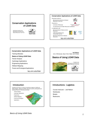
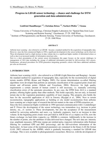
Shallow SloughSample DEMs produced from Riegl Green and IR data (top) and Titan Green and IR data (bottom) indicate the ability ofthe green wavelength data in the Riegl sensor to penetrate through the slough to produce submerged topography. TheTitan Green data did not consistently penetrate through the water column to produce bottom returns.Riegl Green and IRTitan Green and IR
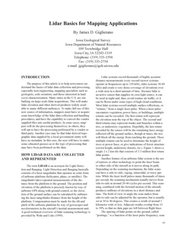
Shallow Slough – ProfilesTitan GreenTitan NIRGREEN POINTS Riegl GreenYELLOW Points Titan GreenThe Riegl green laser returns are consistently lower in areas that have water.
Pilot Project ConclusionsThe modelling capabilities of the two sensors did exhibit significantdifferences in the shallow wet areas within Sloughs and within, and adjacentto, the Tree Islands. The Riegl sensor was able to measure the shallow water depths ( 50 cm – 1 mdeep) more consistently than the Titan sensor. The Riegl sensor uses a short-pulse laser which enables improved depthperformance in very shallow waters.The ability to measure shallow water depths is a very important consideration forthe Everglades National Park.
Pilot Project ReportThe knowledge gained from thecompletion of the pilot projectserved to better scope themethodology to be used for thecollection of LiDAR over a largerarea of the Everglades NationalPark.Dewberry’s Pilot Project Reportis available upon request.
Everglades NP LiDAR ProjectFull Project1211 sq. milesPilot Project
ENP Lidar - Full Project Acquisition PlanPlanned Flying Height 600 m AGLPlanned Density IR wavelength 6 ppsm Green wavelength 8 ppsm Timing Coordinate with NPS Monitor real-time water level gages Monitor ground conditions prior tomobilization Lidar Collection – March – May 2017
Beaver Islands Archipelago &South Manitou Island TopobathyLidar Survey
2015South FoxIslandSouth ManitouIsland20 square miles32 Beaver IslandsArchipelago185 square miles
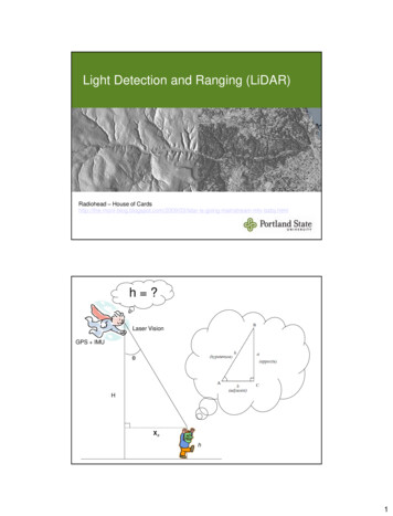
Northern Lake Michigan Topobathy LidarBeaver IslandsArchipelagoSouth ManitouIsland33 Garden Island& Hog Island
Garden and Hog IslandsHog IslandGarden Island34
South Fox Island
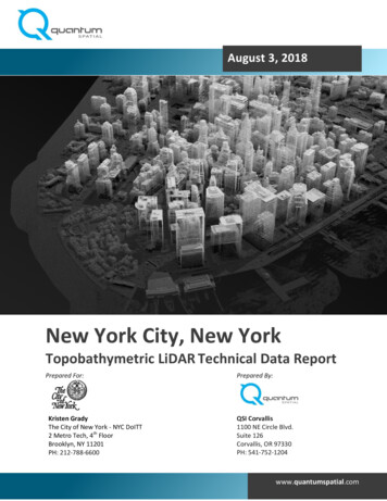
South Manitou Island DEM36
Thank you.Questions?Amar NayegandhiVice PresidentDewberryanayegandhi@dewberry.comPh: 813 421 8642 (office)Cell: 727 967 5005
Complements acoustic (multi -beam sonar) technology Airborne topobathy LiDAR is of high value in filling the "0 to 10 m" depth gap in coastal and riverine areas Rapid survey of shallow water areas that are difficult, dangerous, or impossible to get using water borne methods Ability to rapidly assess riverine and estuary