Transcription
(Re)constructing Communities Design Participation in the Face of ChangeDEMOCRATIC DRAWINGTechniques for Participatory DesignRandolph Hester1ABSTRACTThis is a reflective paper that examines techniquescommunity designers use in creating places with people.One of the difficult tasks community designers performis exchanging complex ideas, science, and technicalinformation with diverse publics. Even more difficult islistening to and then drawing values and ideas of others.More difficult still is to synthesize and draw designsfor imagined environments collaboratively. Althoughdrawing is a key part of professional design education,these nonverbal communication problems challengeevery community designer. Drawing with the public isimmeasurably more complex than the communicationtechniques learned for traditional architectural or planningpractices. So what techniques are used for creatingcollaboratively? A review of community design projectsfrom the proceedings of the Democratic Design in thePacific Rim conferences reveals numerous improvisationsin shared drawing. These “representative representations”might be categorized as follows: 1) representing people,2) exchanging professional knowledge and local wisdomspatially, 3) coauthoring design, 4) empowering people to“represent” themselves, and 5) visualizing deep values:community, stewardship, fairness and distinctive place.The intent here is not to compare techniques acrosscultures, although observations will be made aboutdrawing skills that seem particular to certain socialcontexts. The goal, rather, is to uncover and highlightspatial representation techniques that seem to beparticularly effective in overcoming the difficulties oftransactive design especially of actual form making. Themost used nonverbal techniques include recording socialecology patterns (11 out of 101) and building sense ofcommunity through workdays and walking tours (10 outof 101). Most used of all techniques is the workshop.Three fourths of all the articles (75 out of 101) mentionworkshops without describing non-verbal methods,content or design outcome. The workshop seems to bethe participatory “black box” through which communitydesigners are as inarticulate as traditional designers areabout creative form making. Surprisingly few articles (5 outof 101) describe methods in which design is coauthored,passing representation of form and space back and forthbetween community and designer.176INTRODUCTIONSome years ago I was challenged by a colleague to describeprecisely how participatory designers draw and otherwisecommunicate with communities differently than other designersdo with their traditional clients. He implied that we are nodifferent. We use presentation drawings and models like anyother designer. Then he suggested that community designerstalk more and aren’t as skilled at nonverbal communication.My unprepared response went something like this. In ademocracy, the design of the landscape depends on therepresentation of the public. This public representation, Icalled it “representative representation,” forces inventivedrawing. Drawing against or for others is substantially differentthan drawing with or by others. We, as community designers,draw with the community and frequently they do the drawing.Then I cited drawing on your feet and designing upside down,two techniques I often employ, that suggest that participatorydesign requires special drawing skills.In reality, I wasn’t this articulate, but the idea of representativerepresentation led to more thoughtful reflection.“Representation” refers to our governing process and is thebasis of representative democracy, as in the American slogan,“No taxation without representation!” which rallied sentimentfor the Revolutionary War against England. For designers,representation also refers to the drawings that make an imageor likeness of the place we are creating. When combined thiscreates a community design slogan “No representation withoutrepresentation.” In English, “representational” has a particularmeaning of being realistic or lifelike instead of abstract. Butoften architectural graphics are misrepresentational. Theyare intentionally used to persuade by providing an idealized,misleading picture of what the place would be. Participatorydrawing can be distinguished from traditional architecturalrepresentation by considering these various definitions.Figure 1. No representation withoutrepresentation.2
Randy Hester Democratic DrawingBy “representative representation” I refer to the way drawingis used to communicate with communities as honestly andrealistically as possible through grass roots democracy indirect “face-to-face” exchanges to design the landscape. Thecommunication is about exchange of spatial information, notpersuasion. This communication is often nonverbal becausethe picture is less ambiguous than the spoken word. Typicallythis is accomplished through graphic simulations of ideas,choices and plans for the landscapes we are designing withcommunity members. In participatory work, drawing is used tocollectively visualize, communicate and design.“Drawing” is used here to include the representation of thelandscape by designers and community members through abroad range of media from sketching, painting and collage tomodeling by hand or machine. “Drawing” is also used as anyway to visualize precisely and correctly places being designed.This would include stories turned into pictures, looking atphotographs or visiting nearby precedents, all of which “draw”an image into the mind’s eye of the collective group. Drawingis used in community design for a great variety of purposessuch as understanding a place, communicating the detaileddimensions or essence of a space, exchanging spatial,philosophical or programmatic ideas and imagining choicesfor changing a place. Drawing is used throughout the entiredesign process, from beginning steps like active listening, tofinal steps like post construction evaluation. Obviously only afew of these represent the landscape in a literal and figurativeway, but all are essential to the participatory design process.METHODI focused attention on the techniques participatory designersuse that distinguish us from other architects, landscapearchitects and city designers. I did a content analysis of theproceedings from the conferences on Democratic Design in thePacific Rim, a group who practices only participatory design. Iread every article and studied all graphics for specific referenceto nonverbal techniques used to honestly and precisely designcollaboratively. I reviewed articles from each year the group hasmet. There are 87 papers in the proceedings. I also analyzedthe handouts and notes from field study presentations, four inJapan, seven in Taiwan and three in Hong Kong. This gave atotal of 101 papers that I analyzed.I found five domains of skill especially critical to democraticlandscape design. In this paper I will briefly describe each ofthe following: Representing People Exchanging Professional Knowledge and Local WisdomSpatially Coauthoring Design Empowering People to Represent Themselves. Visualizing Deep Values: Community, Stewardship, Fairnessand Distinctive PlaceI kept a rough numerical tally of techniques as I analyzed thearticles and graphics and I’ll report those. I’ll also draw caseexamples from the proceedings to illustrate the techniques. Ina few cases I’ll rely on methods from my own work.Some generalizations should be made at the outset.Descriptions of spatially explicit democratic design techniqueswere found in about a third of the articles. There were far moredescriptions of verbal techniques such as listening, interviews,surveys and story telling than how that information informeddesign. In most articles workshops are referenced withoutdescription of the content or how that content is explicated inspatial or experiential terms. Similarly, goals like building socialcapital, networks and local identity describe intents with littleexplanation about methods for achieving them.On the other hand, the articles and graphics that are explicitabout techniques that communicate and lead to appropriatedesign offer informative examples of how representativerepresentation is and can be distinguished in ways that trulymatter. I highlight these in the following descriptions.REPRESENTING PEOPLEThe lifting of martial law and increasing democratization inTaiwan, natural disasters, government secrecy in Japan andChina and the civil rights movement and related urban renewaland freeway battles in the United States made designersaware that we did not have the skills to adequately representpeople in the design process. In the worst cases many peoplewere ignored altogether, represented as objects in Cartesianspace, or depicted as standardized normative everyman.Most painfully, minorities, the poor, the elderly or the slightlydeviant were not represented at all. The recognition of thisproblem led to a concerted research effort to understand andportray human perception, cognition and response to both theurban and wild landscape. Sociologists and environmentalpsychologists built a substantial body of research that couldbe applied to design. In retrospect, it seems that the researchfindings that are expressed in visual and spatial terms are mostused by designers; less imageable research, no matter howimportant, remains unused. It is often left to the communitydesigner to figure out how to transform nonspatial researchon cultural rituals and economic variations into a form suitablefor designing places. In other cases, designers must doproject-specific investigations to record idiosyncratic desiresand patterns of behavior. In some few cases designers try topicture the deeper substance of everyday life and the wholeof dwelling as a means to represent and design appropriatelyfor people. In representing people, four methods are most177
(Re)constructing Communities Design Participation in the Face of ChangeFigure 2. Dana Park was redesigned based on social ecology patterns of teen gang territories.described in the participatory literature. I expected these to befound in the content analysis of democratic designers in thePacific Rim: Making Research Spatial, Environmental JusticeMaps, Recording Social Ecology Patterns, and PicturingEveryday Life.Making Research SpatialIncreasingly there is published research available on humanenvironment interactions that can be applied to design. WithPeople in Mind by Rachel and Stephen Kaplan and Robert Ryancomes immediately to mind because it provides social researchfindings and explains the design implications. But most social178research requires “translating” before it is useful for designers.It is not clear how much of this research is being used by thedemocratic designers in the Pacific Rim. Only five of the 101articles reviewed mention using pre-existing research, typicallysite specific census data and historic information. As oneexception, Mark Francis describes using his extensive reviewof recorded trends in park design as a foil for the design ofCentral Park in Davis, California. He expressly wanted the parkto be more of a social center for diverse and divergent groupsthan most parks provide. The result is an unusual combinationof settings from a farmers market and youth center to nativegardens and a central valley beach.
Randy Hester Democratic DrawingFigure 3. The Iraralay Demonstration House was inspired by daily life patterns but accommodates modern needs.I was surprised at how few cases discussed the use of existingresearch to represent people. Do we really ignore alreadypublished research and rely almost exclusively on firsthandobservation and narratives?Environmental Justice MapsFrequently powerless people have difficulty or lack theresources to represent themselves. In cases of extremeoppression, community designers may map relative deprivationthat calls attention to injustices of distribution, access andexclusion. For example, park lands are frequently concentratedin affluent neighborhoods, a situation that is simply accepteduntil dramatically visualized with maps, graphs and diagrams,usually the work of community designers. Environmental justicemaps focusing on availability of park lands, concentration oftoxic sites, relative housing quality, access to natural openspace or other environmental factors can often spur actionamong officials embarrassed by a previously invisible reality.Although making invisible injustices visible is an importantpart of community design history, there were no explicit usesof environmental justice maps in the cases presented in theproceedings.Recording Social Ecology PatternsBehavior and social ecology mapping based on careful firsthandobservation can create patterned visualizations of humanactivity not unlike soils maps or vegetative mosaics. Thesegeometries suggest design solutions. In 1968 we discoveredthe utility of territorial mapping when we created maps of theturf that the Dana Park gang in Cambridge, Massachusettsdefended. We did this by participant observation, hanging outwith the gang for several months, mapping the territory theymost often occupied and from which they excluded others.These maps explained, in spatial terms, conflicts with andcrimes against other users, and ultimately was the primarypiece of analysis that inspired a new park design that solvedthe turf wars.Among the democratic designers recording social ecologypatterns is the most frequently employed nonverbal spatialcommunication tool. It is described as central in ten of the 101articles over a range of settings: the use of creeks, parks andneighborhoods in Northern California; an urban wilderness park,Elephant Mountain, in Taipei, everyday patterns of life of poorwomen in Taiwan; and new immigrants, the aging and youth inHong Kong. In one particularly complete description, the designof the Iraralay Demonstration House on Orchid Island wasgenerated from patterns of everyday life. These patterns werediscovered by the designers only after hours spent observingwhat the Iraralay people did around their houses and village.The resulting house form, although thoroughly “modern” inmany aspects, is obviously inspired by traditional ways ofdwelling and retains every essential activity from ancestralworship centered on the Tomok, to chatting with friends onthe sesdepan. The front yard provides working space and adirect connection to the harbor and ocean beyond. The houseitself is three houses in one to provide seasonal comfort justas traditional homes did. This is the most extensive systematicpatterning reported, and the building form that resulted reflectsthe authenticity and depth of the observation. It is a stunningbuilding, unique to its place and people.Picturing Everyday Life WholeThe careful, systematic recording by a participant observeruncovers patterns of sociopetality, idiosyncratic behavior andsocial interactions prompted by environmental stimuli, but thisseems to be too mechanical for some Pacific Rim designers.They are searching for methods to capture more wholisticallyeveryday life. I discovered the value of this when doing thetown plan for Haleiwa, Hawaii. My son and I used our timeoff to sketch with water colors at important spots frequentedby locals like Matsumoto’s Shave Ice and The Ice House.Through painting common scenes we saw for the first timethe recurring pattern of social centering at the interface ofindoor and outdoor space tempered by changing sun patterns.179
(Re)constructing Communities Design Participation in the Face of ChangeThe habit of lingering in the cool of such places defined theessence of everyday life there. In all of our previous systematicbehavior mapping we hadn’t noticed this sociopetal pattern thatwas unconsciously designed in the vernacular landscape. Weemployed the pattern to create more such successful places.More experimental approaches are reported in the design ofthe spatial scenarios the National Taiwan University groupused to design the shop house reconstruction in Kuo-hsintownship after the earthquake. The design team tried to getthe homeowners to tell them their own stories, to narrate theireveryday lives in space. Eventually the designers were ableto transform the stories into the language of space, providingresidents pictures of how their lives might be in new houses.The memory interviews used in the design of the QuakerRetirement Community in Sandy Springs, Maryland, mayhave likewise given a qualitative picture of everyday life. Thismethod certainly enhanced empathy.Jackie Kwok and Michael Siu describe another innovative wayto picture everyday life. Immigrant women were given camerasand asked to take pictures and then discuss their everydayactivities and settings. This allowed each woman to clearlyexpress her evaluative comments about her living environment,her image of self and family and her everyday life rhythm.I could identify only these few examples and I have readconsiderably between the lines, but I am interested to knowif this desire to capture more wholistically everyday life isgenerating new approaches. Additional information abouttechniques that more qualitatively describe the gestalt ofeveryday life rather than separated patterns would be valuable.I would be particularly interested in knowing if these qualitativegestalts of everyday life are most useful when combined withquantitative pattern languages.EXCHANGING PROFESSIONAL KNOWLEDGE ANDLOCAL WISDOM SPATIALLYFor several years the Pacific Rim Conferences sponsoredlively debate about the role of professional knowledge andnative wisdom. From this John Liu concluded that good resultsare usually attributable to a fully engaged interaction betweenthe professional and the people. How does this interactionoccur? What methods do community designers and communitymembers use to exchange, accumulate and synthesizeknowledge and wisdom?Once the designer can comfortably work with community groups,he or she understandably wants more from them. Teaching laypeople elementary professional spatial thinking can producesignificant public design benefits. All people can map anddraw, some quite well. But like beginning students, they needto be assisted in observing the landscape carefully, thinkingcomplexly about a place of which they only know fragments,imagining nontraditional resources that are so familiar theydon’t see or value them, using precise and sometimes farawayprecedents, accounting for natural changes in the landscape,generating holistic spatial concepts and evaluating plans.And in turn, lay people want more from us. They and webenefit from what they teach us. Community members knowtheir own idiosyncratic needs better than we do, therefore,they need to inform any program. They often know details ofthe culture and ecology from years of dwelling in a place thatprofessionals are likely to miss. In some cases there resides adeep and compelling local wisdom that provides time-honoredprecedents, gestalts, and ways to do things. Here I will highlightsome of the techniques useful in the exchange of local andprofessional knowledge and wisdom. I will concentrate ontechniques that explain how the exchange occurs.Imagining Unseen ResourcesIn all poor communities, and most comfortable ones, successfuldevelopment is dependent on discovering some previouslyunrecognized resource to capitalize the project. This processhas been labeled finding fish heads, a waste product that canbe turned into a benefit. Community designers often draw thefish heads diagram and have community members seek outlocal, undiscovered resources. They may photograph, sketchor simply list them. But often these resources are taken forFigure 4. Painting uncovered the interface of the indoors and the outdoors, sun and shade, wind and calm essentialto seeing everyday life in Haleiwa wholistically.180
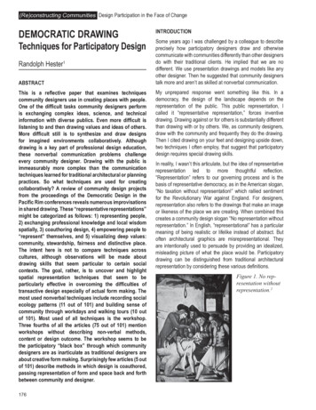
Randy Hester Democratic DrawingFigure 5. A quick sketch showing its reuse saved the Nike Missile Tower from demolition and turned it into a wildlifeobservation deck.granted or viewed negatively; in those cases the designer mustmap and sketch the resources before they are acknowledged.In the design of San Vicente Mountain Park in the SantaMonica mountains in California, our design team recognizedthe remnants of an old Nike missile base as a resource that,if restored, would be useful and, if recycled, reduce cost. Tolocal citizens the remaining tower was a safety hazard, theconcertina wire fences inappropriate in a park and the concretebunkers eyesores. They insisted the military remnants beremoved. During a design workshop, quick sketches showedhow the tower could be transformed into a wildlife observationdeck, the concertina wire lined walkways into interpretive trails,and bunkers into benches. After additional research the militaryconcept was deployed in full as the design gestalt with supportof residents, most of whom had seen the hazards anew throughthe quick sketches. The recycled military artifacts provideda special place, capturing the past while reusing the missilerelics to satisfy changed values for nature study, picnics andmountain biking.In the proceedings are several cases where discoveringunknown resources was essential to the successful design. Inthe case of the various Kyoto Hiroba, a city official with thedesign team inventoried used equipment and materials inthe city storeyards. He then made these resources availableto neighborhood groups. Recycled play equipment, granitecurbs and other materials, which could not otherwise havebeen afforded, became available for use in the parks. Thecommunity groups often used these recycled materials in theirlocal Hiroba. In another case in Matsu, Professors Liu andHsia gave lectures about how the dilapidated buildings couldbe repaired, not just for historic preservation, but also as alocal economic development strategy. This contributed to therecovery of many of the culturally significant stone and woodstructures in which the third conference was held. This seemsa particularly important role for the sensitive outside expert incommunity development.Additional techniques to discover unseen resourcesinclude Lessons from Poverty, Small and Large, Rare andCommonplace, Conscious Nonconsumption and Dirty Enoughto be Happy. These are all described in the Hong Kongproceedings.Thinking ComplexlyCommunity problems are embedded in complex systemsthat require systematic, cross-sectoral thinking. Drawing therelationships of all the components necessary to make asuccessful project can get designers and community to thinkholistically and sometimes outside the box of both narrowinterests and narrow disciplines. A diagram stimulates theorganized brain; a diagrammatic cartoon provokes thinkingoutside the normal. The synetics methods for making thefamiliar strange and the strange familiar can often helpstimulate complex thinking.In the case of a riverfront revitalization project in Mount Vernon,Washington, one middle-aged resident told us, “The river is nota part of me anymore.” Others told us not to worry because theservice clubs would implement the plan. We made cartoonsof a broken heart with his words and the river plan with “theService clubs will do it” as a caption. These were shown asa slide in a community meeting. This was the most powerfuldrawing done during the whole design process. It calledpersonal attention to the community’s disassociation fromthe river and the hopelessness of a river revitalization unlessattitudes changed. The city intended to spend little money onimprovements, and most people expected volunteers to doall the work. The river caused flood damage, was a dumpingground, and separated good and bad districts of the city. Noone seemed to care about it. So why, we wondered, did peoplewant to do anything to revitalize it? The cartoons promptedresidents to begin thinking about the problem more holisticallyand realistically, and most concluded the river had such a badreputation among adults that they didn’t really expect it to be181
(Re)constructing Communities Design Participation in the Face of ChangeFigure 6. Research on roosting areas and foraging requirements of the black-faced spoonbill was drawn as precisespatial geometries to design villages to provide local jobs in bird watching and ecotourism.182
Randy Hester Democratic Drawingrevitalized. By thinking about the project more complexly anddeeply, the community wisely abandoned the idea of doing agrand revitalization. They undertook small projects that serviceclubs and other volunteers could implement.Two cases of such serious, interwoven thinking projects aredescribed in the proceedings. One is the urban design workfor Central Street of Ma-Kung City on the P’eng-hu Islands.Yu Chao-Ching describes a holistic approach that attemptsto address community rehabilitation considering a complexweb of legal and institutional problems, zoning contradictions,conflicting goals of land speculation and historic preservation,uncompetitive businesses and a degraded environment. Forover ten years the designers learned and helped residentsunderstand the complexity. By 1998 the group had developeda comprehensive plan to address the full range of entangledproblems.In a similarly multifaceted problem the Kyoto University teamworking on the Yoshino River attempted to help the communityunderstand the intricate relationships between attachmentto the river, flooding and single-species plantation forestry.Because these cases attempted to address extremely difficultproblems by complex thinking, it would be especially informativeto have updates on their progress. It would also be useful tosee how other community designers come to understand andhelp communicate complexity through graphic means.Making Science SpatialOne of the unique contributions that designers often maketo community design is to translate conservation biology andwildlife habitat research into spatial patterns. At the simplestlevel this involves activity-mapping the territories of wildspecies, similar to recording human ecology patterns. Wedid this to determine the impact of habitat loss and the needfor core areas and corridors in order to preserve the cougarpopulation in the Santa Monica mountains. At a slightly morecomplex level, it involves understanding spatial relationshipsbetween multiple natural species like the cougar, coyote andquail. Human activities further complicate the relationshipsproducing island and edge impacts, triggering rescue effectsand changing species compositions. The fact that ecosystemsare dynamic and evolving, as is the scientific knowledge,makes local wisdom especially important. Often local culturalpatterns of resource use have been created over centuriesto keep a balance with some essential species. Sometimesthis wisdom is overrun or lost. Other times it is surpassed byscience. As with social research on human behavior, urbanecological research almost always needs to be synthesizedconceptually and spatially. In creating Big Wild in Los Angeles,we worked with citizens and scientists to draw research (muchof which seems counter-intuitive due to the intricate food websand habitat relationships) in forms useful to land use planningand design. The drawing of the island effects on wildlife of theproposed Reseda to the Sea Highway was central to the creationof Big Wild in Los Angeles and the eventual abandonment ofthe freeway. Beyond these, visualizations of wildlife, naturalprocesses like the relationship between coefficient of runoffand flooding, hungry water and erosion, or nutrient cyclesremain mysteries until clearly diagrammed. By accuratelyportraying such complex science with citizens they developthe basis for ecologically sound stewardship activities likeecotourism, habitat restoration, species reintroduction, stormwater management and urban vegetation enhancement.In the proceedings there are numerous descriptions ofcommunity efforts to accurately draw natural science findings.Jeff Hou and Marcia McNally point out the joint work of localand international scientists, local fishermen and designersto create a picture of the spatial needs of the black-facedspoonbill. Each knew different parts of the habitat niche puzzle.Most scientists didn’t realize the spoonbills roosted during theday and foraged widely at night, but local fishermen did, andinternational spoonbill expert Malcolm Coulter knew how far,up to 30 kilometers. As more research was done, more precisespatial geometries were drawn for use in the design of villagesto attract economic development based on bird watching.Similar efforts are described by the Kyoto University team intheir work with the Vision 21 Committee. They listened to thedeliberations of the 12 experts who were trying to determine thebest approach to preserve or recreate the ecological systemsof the Yoshino River. The Kyoto Team then synthesized thecomplex and often contradictory science and drew this forthe experts and residents to better understand. This work isparticularly complex due to the dramatically dynamic nature ofthe river system, the scientific findings, politics and social valuesabout the river. Scott McCreary describes similar complexityin the Ecuador ARCO oil exploration debate and the use ofan independent scientific review process to reconcile industryclaims and local knowledge.One of the most difficult aspects of landscape to visualize isnatural change over time, whether it is river dynamics, oldfield succession or park vandalism. The exercise of drawingthe expanding shadow from a maturing tree, or drawing whata place was like a century ago and will be like a century fromnow, can create the most essential visual dialogue. In CastleRock, Washington, which was partly destroyed by the eruptionof Mount Saint Helens, we worked with long-time residents torecreate large pastel drawings of what the Cowlitz River hadbeen like in town before the eruption, immediately after, tenyears after, and wha
drawing. Drawing against or for others is substantially different than drawing with or by others. We, as community designers, draw with the community and frequently they do the drawing. Then I cited drawing on your feet and designing upside down, two techniques I often employ, that suggest that participatory design requires special drawing skills.