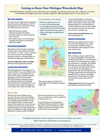
Transcription
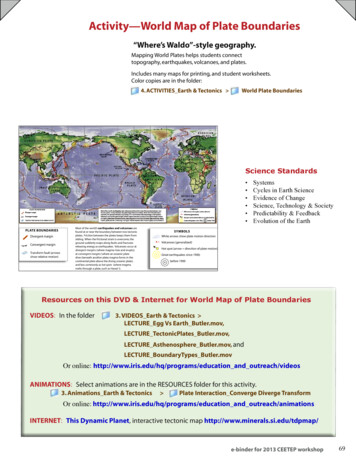
Types of Plate Boundaries Map Identification ActivityDirections: Allow students to work individually or in pairs. Do not put more than two in a groupStudents or pairs will need coloring pencils, the “Types of Plate Boundaries Map” andthe “Types of Plate Boundaries Map Identification Directions”.Students or groups will first lightly shade in each tectonic plate using different colors ifpossible for each plate.Students or groups will then use the “Types of Plate Boundaries Map IdentificationDirections” and the map key to label the various types of plate boundaries on the map.Arrows should also be drawn showing the direction of movement for each boundary.
Types of Plate Boundaries Map Identification Directions A1. Lightly shade in each tectonic/lithospheric plate with adifferent color if possible.2. Use the table below to draw arrows indicating thedirection of plate movement at each boundary.3. Guess the location of the Mid-Atlantic Ridge then checkyour answer with the teacher. If correct, label the locationof the Mid-Atlantic Ridge on your map.Plate BoundariesSouth American Plate – African PlateNorth American Plate – African PlateNorth American Plate – Eurasian PlateAfrican Plate – Antarctic PlateAfrican Plate – Australian PlateAfrican Plate – Indian PlateAfrican Plate – Arabian PlateAfrican Plate – Eurasian PlateArabian Plate – Eurasian PlateArabian Plate – Indian PlateIndian Plate – Eurasian PlateAustralian Plate – Eurasian PlatePacific Plate – Eurasian PlateType of ConvergentConvergentConvergent
Types of Plate Boundaries Map Identification AName Date
Types of Plate Boundaries Map Identification Directions B1. Lightly shade in each tectonic/lithospheric plate with a different color if possible.2. Use the table below and the Map Key on the “Types of Plate Boundaries Map” to drawthe correct symbols identifying each type of plate boundary. The Nazca Plate hasbeen completed on the map as an example.3. Once finished drawing boundary symbols, go back and draw arrows indicating thedirection of plate movement at each boundary meeting point. The Nazca Plate hasbeen completed on the map as an example.4. Guess the location of the Mid-Atlantic Ridge then check your answer with the teacher.If correct, label the location of the Mid-Atlantic Ridge on your map.Plate BoundariesPacific Plate – Nazca PlatePacific Plate – Cocos PlateFrom the top of Cocos Plate – Top of North American to the curveCocos Plate – North American PlateCocos Plate – Caribbean PlateCaribbean – North American PlateCocos Plate – Nazca PlateCaribbean – South American PlateNazca Plate – South American PlateNazca Plate – Antarctic PlateSouth American Plate – Antarctic PlateSouth American Plate – African PlateNorth American Plate – African PlateNorth American Plate – Eurasian PlateAfrican Plate – Antarctic PlateAfrican Plate – Australian PlateAfrican Plate – Indian PlateAfrican Plate – Arabian PlateAfrican Plate – Eurasian PlateArabian Plate – Eurasian PlateArabian Plate – Indian PlateIndian Plate – Eurasian PlateAustralian Plate – Eurasian PlatePacific Plate – Eurasian PlateType of rgentTransformDivergentDo Not DoConvergentDivergentDo Not gentConvergentConvergent
Types of Plate Boundaries Map Identification BName DateType of PlateBoundary undaryXWhy do more volcanoesform along theboundaries of the PacificPlate?
Types of Plate Boundaries Map Identification
Types of Plate Boundaries Map Identification Directions B 1. Lightly shade in each tectonic/lithospheric plate with a different color if possible. 2. Use the table below and the Map Key on the "Types of Plate Boundaries Map" to draw the correct symbols identifying each type of plate boundary. The Nazca Plate has