Transcription
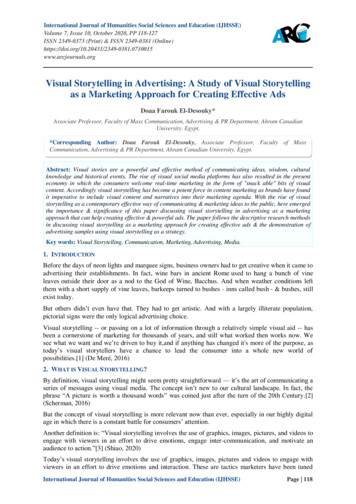
LSA ASSOCIATES, INC.NOVEMBER 2015N.ALBANY 2035 GENERAL PLAN EIRIV. SETTING, IMPACTS, AND MITIGATION MEASURESN. VISUAL RESOURCESVISUAL RESOURCESThis section describes the existing visual resources within the City of Albany and evaluates potentialimpacts of the Draft General Plan on these resources. Included in this section is a description ofexisting visual conditions within Albany as well as an evaluation of the potential effects on visualresources that would result from implementation of the Draft General Plan. The visual analysis isbased on field observations within the City of Albany, background reports prepared for the GeneralPlan Update, and publically-available planning documents.Visual resources include the elements that provide a “sense of place” within Albany and contribute toits unique identity. These elements encompass both natural and human-made features of the localenvironment, as well as cultural characteristics that contribute to how Albany is perceived, or “read”as a place. The setting section describes the primary features contributing to Albany’s natural setting,such as gateways, scenic views, scenic highways, and creek corridors, in addition to the issue of nightlighting and glare.1.SettingThe following section describes Albany’s regional and local visual setting.a.Regional Setting. Albany is the northernmost city in Alameda County and is located on theeast shore of the San Francisco Bay. Albany is located close to two prominent natural features SanFrancisco Bay which acts as the western border of the City and Albany Hill, which rises to approximately 330 feet in the western part of the City. Albany is located in an urbanized area and borders theContra Costa County cities of Richmond on the northwest and El Cerrito on the north, and theAlameda County city of Berkeley on the east and south. Land uses, building types, and densities aresimilar in the adjacent cities and consist of primarily low rise development.b.Local Setting. For the purpose of describing the urban setting, Albany has been divided intoseven contiguous geographic areas, as shown in Figure IV.N-1. The neighborhood areas are listedbelow. Waterfront Freeway Albany Hill University Village Central and Eastern Albany San Pablo Avenue Solano AvenueEach of Albany’s primary geographic areas is defined by a commercial, industrial, or residentialdistrict. Albany has an urban visual character, characterized by lower-rise buildings (mostly one totwo stories in height), extensive landscaping, and a moderate intensity of uses. More dense and urbanareas with taller buildings and more concentrated commercial activity are located along San PabloAvenue and Solano Avenue.P:\ABY1301 Albany GP\PRODUCTS\DEIR\Public\4n-Visual.docx (11/19/15)405
LSA ASSOCIATES, INC.NOVEMBER 2015ALBANY 2035 GENERAL PLAN EIRIV. SETTING, IMPACTS, AND MITIGATION MEASURESN. VISUAL RESOURCESc.Neighborhood Area Characteristics. The visual characteristics of each neighborhood aredescribed below.(1) Waterfront. The Albany waterfront is characterized by expansive open spaces and hasvisual qualities associated with unimproved parkland, such as open fields, trails, a beach, and denseground cover. The area has been modified by a century of landfill, including the creation of theAlbany Neck and Bulb which extend from the natural shoreline west one-half mile into San FranciscoBay. The artificial nature of the landscape is apparent, as scattered construction debris and exposedmetal are visible, and construction rubble exists along the shoreline. A small eucalyptus grove ispresent near the Albany Beach, and other non-native trees such as canary palms, Australian tea trees,and acacia are present. The freeway creates a strong eastern edge to the area and separates thewaterfront from the rest of the City.Golden Gate Fields is a dominant visual feature of the shoreline environment. It includes a multistory grandstand seating 8,000 people and a large club and concessions building. The grandstand andtrack are visible from much of the Central East Bay, including from Interstate 80 (I-80), the south sideof Albany Hill, and the Berkeley Hills. Much of the racetrack property is open space, includingparking lots, the interior turf area, and the track itself. A variety of fencing, lighting, and storagefacilities are also present. The horse stables at the south end of the track are located in Berkeley.San Francisco Bay adds to the expansive visual quality of this area and creates an outward focustoward the water. Visual character is defined primarily by long-range views to the horizon. There arealso views northward toward Point Isabel and southward toward Cesar Chavez Park along theBerkeley waterfront. Short- and mid-range views take in shoreline features (such as concrete debrisand rip rap), abundant scrub and low trees, trails, and tall grasslands. The Albany Bulb has an eclecticcollection of outdoor folk art, much of it fashioned from refuse, that contributes to the wild andremote character of the area and provides a visual cue to the history of the Bulb and its origin as alandfill. The art includes a mix of elements that are transient and elements that are durable andfamiliar to visitors, including human figures crafted from driftwood.(2) Freeway. The I-80 and Interstate 580 (I-580) freeways are among the dominant visualfeatures of the city and create a strong edge between the waterfront and Albany’s neighborhoods. I-80is 10 lanes wide as it passes through Albany, with auxiliary and merge lanes making it appear evenwider. South of Buchanan, frontage roads, ramps, and grade separations give the freeway an expansivepresence. North of Buchannan, the I-80 and I-580 freeways run parallel to one another, with a narrowwedge of light industrial uses and a railroad in between. Elevated ramps at the interchange, and theslight curve of I-80 as it approaches Albany Hill create a change in aspect for drivers and form amemorable transition between the upper Eastshore area (from Richmond northward) and the shorelinearea. The I-80/I-580 interchange itself includes an elevated segment of I-80, as well as flyovers andramps which visually dominate the southern slope of Albany Hill and the approach to the freewaysfrom Buchanan Street.P:\ABY1301 Albany GP\PRODUCTS\DEIR\Public\4n-Visual.docx (11/19/15)406
kRAMPOCerrito CreeISALIAAVEAlbanyHillBUCHANAN STSanFranciscoBayUniversityVillagePLTHFIGURE IV.N-1LEGENDAlbany City LimitFreeway00FEET66066013201320feetBART TracksRailroad TracksSOURCE: CITY OF ALBANY, 2/13/15.I:\ABY1301 Albany GP\figures\Fig IVN1.ai (11/2/15)BuildingAlbany HillWaterfrontSolano AvenueEastshore AreaSan Pablo AvenueUniversity VillageGatewaysCentral/Eastern AlbanyCity of Albany Draft General Plan Update EIRAlbany Visual Analysis Subareas
LSA ASSOCIATES, INC.NOVEMBER 2015ALBANY 2035 GENERAL PLAN EIRIV. SETTING, IMPACTS, AND MITIGATION MEASURESN. VISUAL RESOURCESThis page intentionally left blank.P:\ABY1301 Albany GP\PRODUCTS\DEIR\Public\4n-Visual.docx (11/19/15)408
LSA ASSOCIATES, INC.NOVEMBER 2015ALBANY 2035 GENERAL PLAN EIRIV. SETTING, IMPACTS, AND MITIGATION MEASURESN. VISUAL RESOURCESAlbany’s small industrial district is confined to the linear strip immediately adjacent to the freewayarea. Visually, the industrial district is linked to the freeway, with many of its businesses incorporating signage designed for visibility by passing traffic. The building scale is auto-oriented and thearchitecture is functional, consisting of a number of office-warehouse and industrial buildings. Newerbuildings such as the Target store and a recently completed auto showroom incorporate a contemporary-industrial aesthetic that includes metal and glass. The railroad forms a strong boundary betweenthis area and University Village to the west. North of Buchanan, the character is more eclectic, withvacant land, open storage, and older manufacturing buildings.(3) Albany Hill. Albany Hill is visually important not only because it is a major topographiclandmark but because the hill itself affords panoramic views across Albany, Berkeley, Richmond, ElCerrito and San Francisco Bay. Each side of Albany Hill has a different visual character, shaped bythe street pattern, vegetation, scale of development, and adjacent uses. The north side of the hill is theleast developed, with most of the land contained in a City park. The area is heavily wooded, steep,and somewhat difficult to access. The west side of the hill is dominated by the multi-colored high-risetowers at Gateview and the mid-rise condominiums to the north. The towers (roughly 15-18 storiestall, but still lower than the summit of Albany Hill) are a visual cue to I-80 motorists of the transitionbetween the suburban communities north of Albany and the urban core of the East Bay. The freewayis a dominant presence here, creating a strong horizontal element along the western edge. Eucalyptuswoodlands provide a green backdrop to the east and south, softening the presence of the high-risebuildings, and providing a buffer between this area and the rest of the City.The south and east sides of Albany Hill are mostly urbanized. Views on the south slopes face the Bay,the freeway and racetrack, and points south. As the street grid becomes rectilinear, steep grades arecommon, creating dramatic panoramas. Tree cover is sparse, resulting in expansive views in almostall directions. The building stock consists of smaller cottages and bungalows generally dating from1910-1940, and small apartment buildings from the 1950s and 60s. On the east side of Albany Hill,there is a large stock of multi-family housing and townhouse development from the 1960s and 70s,with many structures built into the hillside with stepped foundations, multi-level decks, and woodshingle finishes. These areas look eastward toward Berkeley and Kensington, with views taking in theUC Campus, the hill neighborhoods, and most of Albany. Features such as the BART tracks, SanPablo Avenue, and Solano Avenue provide visual orientation.(4) University Village. University Village is somewhat self-contained within Albany. Itsstreet network, “master planned” architectural style, building scale, open space pattern, defined edges,and function set it apart from the rest of Albany, although it is easily accessed from surroundingneighborhoods. With the completion of the redevelopment project in 2008, the area presents itself asan aesthetically pleasing, attractively landscaped complex of three-story apartments and townhomes.A consistent color palette, building type, signage program, and landscaping treatment unifies thedevelopment. Views from this area generally take in Albany Hill and the distant East Bay Hills, withfiltered views west to the Bay.Other features which define the aesthetic setting in University Village include the approximately 10acre Gill Tract at the corner of Buchanan and San Pablo Avenue. The use of the tract for agriculturalresearch in an otherwise urban context is noteworthy.P:\ABY1301 Albany GP\PRODUCTS\DEIR\Public\4n-Visual.docx (11/19/15)409
LSA ASSOCIATES, INC.NOVEMBER 2015ALBANY 2035 GENERAL PLAN EIRIV. SETTING, IMPACTS, AND MITIGATION MEASURESN. VISUAL RESOURCES(5) Central and Eastern Albany. The remainder of Albany is characterized by mostlyresidential uses, fairly consistent in form and density, organized on a rectilinear street grid. Twocommercial corridors—San Pablo and Solano Avenues—bisect the grid and provide communitygathering places, business districts, and civic activities. The two corridors have been called out asseparate neighborhoods and are described later in this chapter.The character of the residential neighborhoods is eclectic. There is a predominance of one and twostory stucco and wood single-family bungalows on lots that generally range from 2,500 to 5,000square feet. Most of the housing stock dates from 1910-1945, although many homes have beenexpanded, remodeled, and updated. There is tremendous architectural diversity, including Tudor,Mission, Spanish Revival, Craftsman, and Contemporary styles. The color palette of the homes also isdiverse, although pastel and earth-tones are predominant. The combination of small lots, consistentscale, eclectic architecture, front porches, narrow driveways, and mature trees gives theneighborhoods a comfortable and pleasant quality that is highly valued.Most homes include small landscaped front yards, featuring a mix of ornamental plants, shrubs, andnative species. Street trees are present on most blocks, but the overall tree canopy is somewhat sparse.Large specimen trees, including redwoods, Monterey pine, palms, and eucalyptus, occur in scatteredlocations, providing visual orientation. For the most part, utility lines are above ground and telephonepoles and overhead wires are a recurring element of the streetscape.Many homes were built as single story bungalows of less than 1,400 square feet. The desire to expandand update such homes has accelerated as their value has increased and as family size and incomehave increased. Given the narrow dimensions and small size of most lots, adding on often requires asecond story. Albany has adopted design guidelines intended to reduce the perceived mass of twostory homes from the street, minimize the effect of such additions on adjacent properties, and promotearchitectural compatibility. On some homes with second story additions, the upper floor is recessedfrom the front facade, maintaining a lower profile at the street.Some homes in Central and Eastern Albany have filtered or partial views of nearby landmarks,particularly San Francisco Bay and the hills of Marin County, the Golden Gate, San Franciscoskyline, Berkeley Hills, El Cerrito Hills, and Albany Hill. Most views are short-range, taking inlandscaped yards, nearby homes, street trees, and adjacent streets. In the eastern part of Albany, theterrain is gently sloped.Concentrations of multi-family development exist on the blocks between Brighton Avenue and ElCerrito Plaza, and along Adams Street and Kains Avenue. Multi-family structures are generally twoto four stories in height, with many incorporating modernist or mid-century modern designs typical ofapartment construction in the 1950s and 60s. Some are “soft story” buildings with tuck-under carportsat the street level and one or two stories of apartments above. The quality and condition of thesebuildings is variable, with some in excellent condition and others in need of maintenance and repair.A number of distinct uses in Central and Eastern Albany’s neighborhoods stand out as visuallandmarks. These include churches, such as Albany United Methodist on Marin Avenue and St.Albans on Washington at Curtis, and civic buildings such as the Community Center and Library onMarin Avenue and the Veterans Memorial Building in Memorial Park. Schools are also a prominentfeature of the Albany landscape, particularly St. Mary’s College High School in the southeasternP:\ABY1301 Albany GP\PRODUCTS\DEIR\Public\4n-Visual.docx (11/19/15)410
LSA ASSOCIATES, INC.NOVEMBER 2015ALBANY 2035 GENERAL PLAN EIRIV. SETTING, IMPACTS, AND MITIGATION MEASURESN. VISUAL RESOURCEScorner of the City and Albany High School and Middle School in the north-central part of the City.City parks and open spaces complement the residential areas, particularly Jewel’s Terrace Park in theAlbany Terrace area and Memorial Park in northeast Albany. There are also a number of distinctivevisual features, such as the elevated BART tracks along the Ohlone Greenway and the wide grassymedian on Key Route Boulevard.(6) San Pablo Avenue. San Pablo Avenue has historically been an auto-orientedthoroughfare. It was once part of the Lincoln Highway, the first transcontinental highway forautomobiles, and it supported a streetcar during the early 20th Century. Although its function as aninterstate highway ended more than 50 years ago, the legacy persists in the character and mix of usesalong the Avenue. San Pablo Avenue is still a State Route (SR 123). Large signs and parking lots areprominent and many businesses are convenience-based or provide goods and services related toautomobiles. Buildings range from one to four stories in height, and land uses include auto sales andparts, auto service and repair, shopping centers, freestanding retail uses, restaurants, offices, servicebusinesses, and multi-family residential.The corridor lacks a common design language or architectural aesthetic. Most blocks are characterized by a mix of building styles, signage types, setbacks, and off-street parking provisions. Sidewalkand median investments have improved the visual quality of the public space, and recent privatedevelopment has created more cohesion.During the last 20 years, the corridor has begun to transform into a more pedestrian-oriented district,with landscaping, streetscape amenities, and mixed-use development introduced. One of thedistinguishing characteristics of the newer projects is that they contain retail storefronts opening tothe sidewalk rather than parking lots along the street frontage. Parking on these properties is locatedbeneath or behind the building, and residential uses are located on upper stories.Since the late 1980s, Albany’s policy has been to make the intersection of San Pablo and SolanoAvenue a more visually distinctive node. Tightly clustered storefront buildings along this stretch ofSan Pablo help the area function as an extension of the Solano Avenue shopping district. One blocksouth, the Buchanan/Marin/San Pablo intersection is another important node. City Hall and the Policeand Fire stations create a focal point, but two service stations on the east side of the intersectionsuggest the node has not reached its full potential. The potential for a more positive visual impact alsoexists further south along the west side of San Pablo Avenue, where vacant parcels fronting theAvenue near University Village are planned for development with new housing and retail uses. Thenorthern Albany gateway in the vicinity of Albany Bowl also has the potential to be more visuallydistinct.Views from San Pablo Avenue are generally oriented to the Avenue itself, as the flat terrain tends tolimit broad panoramas. Albany Hill is a dominant visual feature in the northern part of the corridor.The Berkeley and El Cerrito Hills are generally visible to the east, particularly at the intersectingstreets and from parking lots. Utilities are underground, with cobra head light fixtures spaced atregular intervals along the Avenue. Mature street trees are regularly spaced on most blocks. A groveof mature evergreens and palms creates a visual landmark just south of City Hall.P:\ABY1301 Albany GP\PRODUCTS\DEIR\Public\4n-Visual.docx (11/19/15)411
LSA ASSOCIATES, INC.NOVEMBER 2015ALBANY 2035 GENERAL PLAN EIRIV. SETTING, IMPACTS, AND MITIGATION MEASURESN. VISUAL RESOURCES(7) Solano Avenue. Solano Avenue is a pedestrian-oriented shopping district characterizedby almost continuous ground floor commercial activity from Adams Street to the Berkeley border, 15blocks to the east. The street is characterized by short blocks, a well-defined street wall, smallstorefronts with large transparent windows, eclectic architecture, active ground floor uses, anddiagonal street parking. These factors combine to create a distinct “village” ambiance that invitesstrolling, browsing, and pedestrian interactions.Pedestrian improvements such as curb bulb-outs, landscaping, benches, bus shelters, and small plazas,where implemented, have enhanced the character of this area, and provided gathering places andseating areas along the Avenue. Utilities are underground and antique lighting standards are in place.Many of the buildings feature awnings, creative signage, interesting window displays, andarchitectural elements that create visual interest.Most blocks contain one- and two-story wood-frame commercial buildings built to the front setback,and articulated with small storefronts. Some are simple and lack architectural details, and someinclude embellishments such as turrets, tile mosaics, and parapet walls. The corner buildings ofteninclude special treatments which define the end of the block. Building styles include Mediterranean,Tudor, Mid-Century Modern, Art Deco, and California Contemporary, as well as numerous simplevernacular commercial structures from the 1920s and 30s. Exterior finishes include brick, ceramictile, stucco, wood, and other surfaces, while rooflines and materials vary widely from red clay tiles tomansard-style. The overall effect is eclectic and memorable.A few larger auto-oriented uses exist along the Avenue. These include the Safeway store, a CVSpharmacy, and a 7-Eleven store. Some blocks include a single two- or three-story apartment building,generally dating from the 1940s to the 1960s, with carports or garages at the street level. While thereare no designated historical landmarks on the Avenue, a few buildings are notable for their size, age,and function. These include the Albany Theater, the Church on the Corner, the Post Office, CornellSchool, and an AT&T facility near the Berkeley border.Views from the Solano corridor are primarily short-range and focus on buildings, landscapes, andstreet trees. On most blocks there are longer-distance views to the Berkeley Hills to the east, the ElCerrito Hills to the north, and Albany Hill to the west. Filtered views of the Bay and distantlandmarks in San Francisco and Marin County exist in a few locations.d.Visual Characteristics. The following section describes Albany’s visual characteristics.(1) Gateways and Landmarks. Gateways are an important aspect of community design.They create a first impression and lasting image. A well-designed gateway can communicate animage of vitality and prosperity while a poorly managed or neglected gateway can communicatedisinvestment and a lack of civic pride. The major gateways into Albany are generally considered tobe Buchanan Street east of I-80: the locations where San Pablo Avenue enters the City on the northand south, and the locations where Marin and Solano Avenues enter the City on the east. Albany’sPublic Art Master Plan places a special focus on beautifying these locations.The Buchanan Gateway currently includes the “Rose Wave” sculpture and the new Buchanan bikepath. It is further defined by the large USDA building, the open space at Ocean View Park, the GillP:\ABY1301 Albany GP\PRODUCTS\DEIR\Public\4n-Visual.docx (11/19/15)412
LSA ASSOCIATES, INC.NOVEMBER 2015ALBANY 2035 GENERAL PLAN EIRIV. SETTING, IMPACTS, AND MITIGATION MEASURESN. VISUAL RESOURCESTract farm, and the residential area ascending up Albany Hill on the north. City Hall is effectively theterminus of this gateway.The north and south San Pablo Avenue gateways are only eight blocks apart. At the northernboundary, there is little awareness of either the Albany line or Cerrito Creek below. At the southernboundary, the UC property provides an opportunity for a more distinctive southern gateway. A largepiece of public art was recently approved in association with new mixed-use development proposedfor this area.The eastern gateway along Solano Avenue is vaguely defined, in part because of a peculiarity in theCity boundary. Albany’s easternmost point is between Ventura and Tulare Avenues, but for fourblocks from this point west, Albany occupies the southern side of the street while the northern side isin Berkeley. The first point where Albany occupies both sides of the street is between Curtis andNeilson Streets. At this point, an older sign made from black steel I-beams reads “Welcome toAlbany.”(2) Landscaping and Street Trees. Trees, shrubs, and flowers enhance Albany’sappearance and provide a contrast to the built environment. Trees also offer shade for pedestrians,provide privacy and a buffer from noise, relieve some of the effects of air pollution, and introducenature and habitat into an urban environment. Trees can have positive effects on stormwater runoffand water quality, and can result in increased property values. Trees can also sequester carbon, andcontribute to efforts to reduce greenhouse gas emissions.Albany has developed an urban forestry program to promote street tree planting and tree maintenancebest practices. Pruning of street trees is conducted on a three to four year cycle, with a priority onfast-growing trees or potential hazards. Albany also conducts tree planting and concrete removal for afee when requested by homeowners. A landscape and lighting assessment district generates revenuesfor street tree planting, landscaping, public street lighting, sidewalks, and park and recreationalimprovements.There are approximately 5,000 publicly-owned trees in Albany, located in City parks and along Citystreets. In 2010, an updated list of recommended street tree species was adopted based on therecommendations of a Tree Task Force that met for two years prior. Residents may pick a tree fromthe list and contact the City to arrange for planting. Trees are planted throughout the year, as demandand availability allow. Once planted, residents must agree to water trees according to the instructionsprovided by the City, and accept liability for tree-related hazards. The City conducts pruning andmaintenance. For new construction projects, owners are generally required to purchase trees to beplanted by the City in the street right-of-way adjacent to the project.Over the years, a number of specific programs have been implemented to incentivize tree planting.These include the Block Urban Forest Focus (BUFF) process, in which neighbors mobilize theirblock to identify tree planting sites, remove concrete, plant trees and ground cover, and prune existingtrees. In addition, a Tree Fund has been established to provide a repository for persons wishing todonate money to plant and sustain the City’s urban forest. Such programs are intended to build asense of community and stewardship, while also greening the City.P:\ABY1301 Albany GP\PRODUCTS\DEIR\Public\4n-Visual.docx (11/19/15)413
LSA ASSOCIATES, INC.NOVEMBER 2015ALBANY 2035 GENERAL PLAN EIRIV. SETTING, IMPACTS, AND MITIGATION MEASURESN. VISUAL RESOURCESHomeowners are asked to support and complement City tree maintenance efforts by watering andmulching their street trees, and keeping weeds from interfering with tree development. The Cityoccasionally re-stakes young trees. For mature trees, the City removes dead branches, addressesconflicts with overhead wires, and prunes branches that obscure signs or create sidewalk or roadhazards. The City also assists with sidewalk damage that is caused by street trees, although theprimary responsibility for sidewalk repair falls on the homeowner.The City has adopted an official tree removal policy, which includes procedures for emergency andnon-emergency removal of trees on public property. Causes for emergency removal includeimmediate, clear, and imminent danger to the public. The policy calls for a replacement tree to beplanted in 60 days or less. For non-emergency removal, permission must be granted by the Directorof Community Development, following a noticed public hearing before the Parks and RecreationCommission. Criteria have been established to justify removal, such as a finding that the tree isdiseased, damaged, causing frequent sidewalk or utility damage, or poses a hazard. The City itselfmay apply for a tree removal permit, subject to these same criteria. The Parks and RecreationCommission may grant or deny a tree removal application permit. Their decision is appealable to theCity Council.(3) Public Art Program. Public art includes artwork in the public realm, such as sculptures,murals and mosaics. Public art creates a sense of space and improves the quality and design ofbuildings, streetscapes and public places, giving a stronger feeling of identity. Architecture andlandscapes can be a form of public art, as they express a particular perspective and can provide asource of beauty and interest.The City has adopted an Art in Public Places Ordinance as a way to fund public art in Albany. Certaintypes of public and private construction projects must either include a public art component, or pay anin-lieu fee which contributes to the development of public art elsewhere in the City. Any project witha construction cost greater than 300,000 must include a public art component equal to 1.75 percentof the total construction cost, or contribute 1.75 percent of the project cost to the Public Art Fund.The City has adopted a Public Arts Master Plan to guide the siting of public art. Locations throughoutthe City have been evaluated for future art pieces, and several prominent and high visibility sites havebeen identified as candidates. Notable existing art installations include “Herons” at the Albanywaterfront, the “Rose Wave” on Buchanan Street, “Long Song” in Memorial Park, and a tile mural inTerrace Park.(4) Scenic Views and Scenic Highways. California's Scenic Highway Program was createdby the State legislature in 1963. Its purpose is to protect and enhance the natural scenic beauty ofCalifornia highways and adjacent corridors through special conservation treatment. Designated scenichighways are subject to various regulations and guidelines to avoid diminishing their aesthetic values.There are no officially designated State scenic highways in Albany.P:\ABY1301 Albany GP\PRODUCTS\DEIR\Public\4n-Visual.docx (11/19/15)414
LSA ASSOCIATES, INC.NOVEMBER 2015ALBANY 2035 GENERAL PLAN EIRIV. SETTING, IMPACTS, AND MITIGATION MEASURESN. VISUAL RESOURCESe.Light and Glare. This section describes the existing conditions of light and glare in Albany.Light pollution refers to forms of unwanted light in the night sky, including glare, sky glow,excessive night lighting, and diminished night sky visibility. Existing sources of nighttime light inand around Albany include street lights, parking lot lighting, building lighting, illuminated signs,vehicle h
Nov 04, 2015 · Contra Costa County cities of Richmond on the northwest and El Cerrito on the north, and the Alameda County city of Berkeley on the east and south. . A variety of fencing, lighting, and storage facilities are also present. The horse stables at the south end of the track are located in Ber