Transcription
PROVISIONAL GEOLOGIC MAP OF THE TINTIC MOUNTAINQUADRANGLE, JUAB AND UTAH COUNTIES, UTAHbyJeffrey D. Keith1, David G. Tingey1, Judith L. Hannah2, Steven T. Nelson1,Daniel K. Moore3, Teresa M. Cannan3, Alexander P. MacBeth2, Tamalyn Pulsifer31Brigham Young University, Department of Geological Sciences, Provo, UT 84602Formerly University of Vermont, Department of Geology, Burlington VT 05405, and U.S. Geological Survey3Formerly Brigham Young University, Department of Geological Sciences, Provo, UT 846022This open-file release makes information available to the public that may not conform to UGS technical, editorial,or policy standards; this should be considered by an individual or group planning to take action based on the contents ofthis report. The Utah Department of Natural Resources, Utah Geological Survey, makes no warranty, expressed or implied,regarding its suitability for a particular use. The Utah Department of Natural Resources, Utah Geological Survey, shall notbe liable under any circumstances for any direct, indirect, special, incidental, or consequential damages with respect toclaims by users of this product.This geologic map was funded in part by the Utah Geological Survey, and ancillary work was funded by the U.S.Geological Survey as part of the CUSMAP (Conterminous United States Mineral Assessment Program).OPEN-FILE REPORT 545UTAH GEOLOGICAL SURVEYa division ofUtah Department of Natural Resources2009
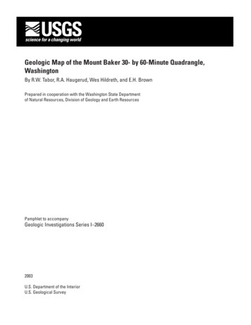
INTRODUCTIONLocation, Methods, and Prior WorkThe Tintic Mountain quadrangle is located in central Utah about 6 miles (10 km) south ofEureka near the central part of the East Tintic Mountains. The quadrangle is on the east marginof the Basin and Range Physiographic Province.Because the quadrangle is partly within the East Tintic mining district, numerousgeologic studies have been done on the area. Morris and Lovering (1979) prepared the mostcomprehensive report on the district; other examples are listed in the references in this open-filereport. U.S. Geological Survey geologist H.T. Morris (1975) previously mapped the geology ofthe Tintic Mountain quadrangle. Subsequent mapping occurred in the west (Hannah andMacBeth, 1990) and northeast (Keith and others, 1989, 1991) parts of the quadrangle. This mapfocuses on the Tertiary volcanic rocks, and relies on geochemical, geochronologic, andstratigraphic data from Moore’s M.S. thesis (1993) supervised by J.D. Keith. The stratigraphy ofthe Tintic Mountain Volcanic Group has been revised from that of Morris and Lovering (1979)with a mix of formal and informal rock unit names. The quadrangle was remapped in an effortto update and build upon the prior mapping and geologic studies of H.T. Morris.This open-file report is based primarily on mapping completed in 1991-1993; parts of thequadrangle were mapped by coauthors Hannah, Cannan and MacBeth (1991-1992), Keith andMoore (1991-1992), Moore (1991-1992), and Tingey (1993), as depicted on the index to areas ofresponsibility for geologic mapping (figure 1). Age determinations were conducted by S.T.Nelson. The map was compiled by T. Pulsifer under the direction of J.D. Keith and D.G.Tingey. Moore and others (2007) subsequently discussed petrogenesis of the East Tinticvolcanic field based on Moore (1993).This geologic map focuses on the Tertiary igneous rocks in part of the East TinticMountains, and supercedes the reports of Morris (1975), and Hannah and MacBeth (1990). Therevised stratigraphy of the Tintic Mountain Volcanic Group in this open-file report was partlyshown in Keith and others (1989, 1991) and Hintze (1988, chart 32, p. 149). The surfacegeology of the Tintic Mountain area is extremely complex and we recognize that someinconsistencies have not been resolved. Notably, the correlation chart is not fully compatiblewith the mapping and isotopic ages. Some isotopic age data do not match the physicalstratigraphy and sample locations and units sampled are uncertain. Also, thicknesses shown oncross sections do not match those on nearby maps. A structural or stratigraphic explanation isneeded to explain why map unit Trp is exposed on both sides of the range. Age ranges for Trpand some other map units may be longer than shown in the correlation chart. Not all units arenamed on the basis of their geochemistry. Geochemical and geochronologic research areongoing.Inferred Calderas and Geologic HistoryThe Tintic Mountain quadrangle is characterized by exposures of Eocene and Oligocene volcanic,sedimentary, and intrusive rocks that lie unconformably upon faulted lower Paleozoic sedimentary rocks1
(Cambrian to Devonian?). Volcanic eruptions produced three nested calderas that are incompletelydelimited, but likely extend into the adjacent Eureka, Furner Ridge, and McIntyre quadrangles. Eruptionof the Fernow Quartz Latite (map symbol Tf) created the oldest of the three calderas (Fernow caldera),and severely altered the Herkimer Limestone (Ch) and Fish Haven Dolomite (Ofh) near the caldera wall inthe southwest part of the map area. The caldera is dated at 34.71 0.19 Ma or older, based on thepresumed correlation with the Packard Quartz Latite by Moore (1993).Subsequent eruption of the lava flows of Rattlesnake Peak (Trp) created a second caldera(Rattlesnake Peak caldera), destroying the northern extent of the Fernow caldera. Collapse of the calderawalls following eruption resulted in the entrainment of large blocks of Paleozoic rocks, most notably theTintic Quartzite (Ct), within the lava flows. This caldera location is crudely comparable to the Tinticcaldera proposed by Morris (1975) and mostly encompasses unit Trp.Eruption of the tuff member of the Copperopolis Latite (Tct) created a third caldera(Copperopolis Latite caldera) approximately 7 miles (11 km) in diameter. Its location is based on: (1) thesub-circular distribution of several intrusive units, including the Silver City stock (Tsc) and a breccia pipe(Tbp), present exclusively within the proposed caldera; (2) the arcuate contact of the tuff member of theCopperopolis Latite (Tct) with the lava flows of Rattlesnake Peak (Trp); (3) the observation that tuffmember thickness within the proposed caldera is 425 feet ( 130 m) thicker than the tuff outside thecaldera (Hannah and others, 1991; Moore, 1993); (4) the presence of lacustrine strata (Tsu, Tsl) within thecaldera.The Copperopolis Latite caldera was later intruded by the Sunrise Peak Monzonite Porphyry(Tsp). Lacustrine shale clasts (Tsl) ripped up during the intrusion and related lava flows are visible in theagglomerates of Sunrise Peak (Tspf) (Lindgren and Laughlin, 1919; Keith and others, 1991). Overlyingvolcanoclastic sedimentary strata (Tse) record deposition in a terrain of high relief (Keith and others,1991).Several volcanic units and intrusions postdate the lacustrine and sedimentary units. Lava flowsof the shoshonite of Buckhorn Mountain (Tbm) filled and overflowed the Copperopolis Latite caldera.The latite of Dry Herd Canyon (Tdh), latite of Little Dog Canyon (Tld), and the Latite Ridge Latite (Tlr)overlie these shoshonite lava flows in the center of the quadrangle. Volcaniclastic strata (Ts) arepreserved only where overlain by the Latite Ridge Latite (Tlr) (Moore, 1993). Failure of thevolcaniclastic strata (Ts) led to Quaternary-age landslides involving the Latite Ridge Latite (Tlr) in thesouthwest and south-central portions of the quadrangle. The latite of Rock Canyon (Trc) has 40Ar/39Ar agesof 33.72 0.08 and 33.87 0.13 Ma (Moore, 1993) and overlies the latite of Little Dog Canyon (Tld).Several intrusive rock units occur in the quadrangle. A dike swarm at Paul Bunyans Woodpile(Tli) is one of the outstanding geologic features within the Tintic Mountain quadrangle. These biotitelatite intrusions (Tli), here correlated with the latite of Dry Herd Canyon (Tdh) lava flows, occurexclusively within the proposed Copperopolis Latite caldera, as does the Silver City stock (Tsc). Theintrusions of Keystone Springs (Tks), which ended at 34.03 0.1 Ma (Moore, 1993), are recognizedwithin the southern portion of the Copperopolis Latite caldera, as well as within the Rattlesnake Peakcaldera. The monzonite porphyry of Silver City (Tsc), dated at 32.7 0.2 Ma, is the largest intrusivebody in the East Tintic Mountains and is associated with mineralization (Keith and others, 1991; Moore,1993).Tertiary alluvium (Ta) shed from the East Tintic Mountains contains Tertiary volcanic andPaleozoic sedimentary rock material and postdate volcanism. The Goshen fault (Jensen, 1984), whichextends into the southeastern part of the quadrangle, has displaced the Tertiary alluvium, as well as thepreviously faulted Paleozoic units and Tertiary volcanic rocks.2
ACKNOWLEDGMENTSThis geologic map was funded in part by the Utah Geological Survey, and ancillary workwas funded by the U.S. Geological Survey as part of the CUSMAP (Conterminous United StatesMineral Assessment Program). UGS staff Jon K. King, Donald Clark, and Grant Willisconducted preliminary reviews of this map.3
MAP UNIT DESCRIPTIONSQUATERNARY SURFICIAL DEPOSITSQayYounger alluvium (Holocene) – Poorly consolidated deposits of stream alluvium incisedinto older alluvial deposits; mapped along most primary stream drainages, and alsoincludes small areas of fan alluvium and colluvium; exposed thickness as much as 5 feet(2 m), total thickness unknown.QaoOlder alluvium (Holocene to Pleistocene) – Poorly consolidated deposits of streamalluvium and fan alluvium typically present above younger stream deposits; includessmall areas of older stream alluvium and colluvium; mapped in Furner Valley, Little DogValley, Maple and Jims Springs area, Government Canyon area, and Tintic Valley;exposed thickness as much as 10 feet (3 m), total thickness unknown.QafAlluvial-fan deposits, undivided (Holocene to Pleistocene) – Poorly consolidateddeposits of coalescing fan alluvium in Goshen Valley; includes unmapped colluviumalong valley margins; locally incised by younger alluvium of active streams; exposedthickness as much as 10 feet (3 m), total thickness unknown.QmsLandslide and slump deposits (Holocene to Pleistocene) – Landslides and slumpsdeveloped on “weak” volcanic rock units; mapped near Kessler Spring, Riley Springs,Little Valley, and Jumpoff Spring areas; total thickness variable and unknown.UnconformityTERTIARY SEDIMENTARY AND VOLCANIC ROCKSTaTertiary alluvium (Oligocene?) – High-level alluvial fans that are dissected and eroded;contains clay to gravel from Eocene-Oligocene volcanic rocks and Paleozoic units; age(s)uncertain but postdates volcanism; thickness is 0 to 250 feet (0-80 m).Unconformity?TrcLatite of Rock Canyon (Oligocene) – Black, gray to reddish brown latitic lava flows andvitrophyres with conspicuous phenocrysts of biotite and plagioclase in hand sample;clinopyroxene, titanomagnetite, and apatite are always apparent in thin section;orthopyroxene, amphibole, sanidine, and magmatic sulfide blebs present in somesamples; informally named for exposures in the Eureka quadrangle; thickness is 0 to1500 feet (0-460 m).TlrLatite Ridge Latite (Eocene) – White to reddish brown, trachytic, ash-flow tuff; the tuff isdensely welded, eutaxitic, locally perlitic, and crystal poor; contains phenocrysts of plagioclase,biotite, and clinopyroxene; aphanitic-porphyritic, lapilli-sized lithic fragments and vitrophyricclasts of andesitic lava are also present; named by Morris and Lovering (1979) for exposures inthe Eureka quadrangle; thickness is 0 to 500 feet (0-150 m).4
TsVolcaniclastic strata (Eocene) – Interbedded volcanic sandstone and conglomerate; strata areheterolithic, poorly sorted and stratified, and consist of angular, pebble- and cobble-sizefragments of dark lava in a matrix of gray, biotite-bearing, volcanoclastic silt; clasts are muchlarger and more abundant in conglomerates; cross-stratification is common in the sandstones;thickness is 0 to 500 feet (0-150 m).TldLatite of Little Dog Canyon (Eocene) – Black, blue-gray, and gr ay-green, f laggy,porphyritic-aphanitic, felty, latitic lava flows; weathered surfaces are brown and subangularto smooth; forms a few poorly expo sed outcrops; i nformally name d for ex posures i n th eTintic Mountain quadrangle; thickness is 0 to 250 feet (0-80 m).TdhLatite of Dry Herd Canyon (Eocene) – Black, brown-black, and green vitrophyric andporphyritic-aphanitic lava flows; the flows are dense to scoriaceous, locally amygdaloidal, andcontain phenocrysts of plagioclase, clinopyroxene, Fe-Ti oxides, and orthopyroxene; poorlyexposed unit; commonly only cobble-size float is present; informally named for exposures in theEureka quadrangle; thickness is 0 to 350 feet (0-110 m).TbluUpper biotite latite flows (Eocene) – Black to gray lava flows and vitrophyres with prominentbiotite and plagioclase phenocrysts in hand sample; clinopyroxene, orthopyroxene,titanomagnetite, apatite, and magmatic sulfide blebs are also present, but are not obvious in handsample; distinguished in the field from other biotite-latite flow units only on the basis ofstratigraphic position; stratigraphically above the mafic flow sequence (unit Tbm); thickness is 0 to350 feet (0-110 m).TbmShoshonite of Buckhorn Mountain (Eocene) – Dark to variably colored lava flows, breccias,and agglomerates with little or no biotite apparent in hand sample; these flows and breccias arecommonly vesicular and mildly altered; clinopyroxene, plagioclase, orthopyroxene,titanomagnetite, apatite, traces of magmatic sulfides, and a few strongly resorbed and oxidizedrelict biotite crystals can also be found in thin section; informally named for exposures in theTintic Mountain quadrangle; thickness is 0 to 500 feet (0-150 m).TblfLower biotite latite flows (Eocene) – Light gray to red brown lava flows with conspicuousbiotite and plagioclase phenocrysts in hand sample; clinopyroxene, titanomagnetite, apatite, andtraces of amphibole and magmatic sulfide blebs can also be found in thin section; separated fromother biotite lava flow units during mapping based on stratigraphic position beneath theshoshonite of Buckhorn Mountain; thickness is 0 to 200 feet (0-60 m).TseEpiclastic strata (Eocene) – Poorly stratified volcaniclastic sedimentary rocks, includingconglomerate, near Government Canyon; original composition often obscured by intensealteration; rarely, angular clasts of Tintic Quartzite or lower Paleozoic carbonate units arepresent; thickness is 0 to 150 feet (0-50 m).TsuUpper lacustrine strata (Eocene) – Alternating beds of white limestone and dark-gray organicrich shale containing abundant plant remains; generally, very poorly exposed; small pebble- andcobble-size fragments in float are typically the only clue to its presence; this unit represents5
deposits in a lake that formed in the Copperopolis Latite caldera; thickness is about 50 feet (15m).TspfFlows and agglomerates of Sunrise Peak (Eocene) – Light-green to light-brown, slabbyweathering, latitic lava flows in which plagioclase phenocrysts are conspicuous in hand sample;other phenocrysts include biotite, clinopyroxene, titanomagnetite, and apatite; field relationshipsand composition suggest that the lava flows vented from the Sunrise Peak stock (and associateddikes); the agglomerate occupies the same stratigraphic position and contains the samephenocrysts except that biotite crystals are larger in size and more abundant in both fresh andaltered outcrops; informally named for exposures in the Tintic Mountain quadrangle; thickness is 0to 600 feet (0-180 m).TslLower lacustrine strata (Eocene) – Light-colored, fissile shale, with lesser amounts ofmudstone and volcaniclastic sandstone; strata include ovoidal structures replaced by pyrite thatmay represent gastropods; unit weathers easily and, therefore, is poorly exposed; thickness is 0 to350 feet (0-110 m).TctTuff member of Copperopolis Latite (Eocene) – Thin- to very thick-bedded, vitrophyric,lithic, phenocryst-poor, ash-flow tuff and minor autobrecciated tuff; rare, unaltered tuff ismoderately welded and eutaxitic; brecciated tuff consists of angular tuff blocks in a matrix of thesame tuff; unit includes lapilli- and block-sized (up to 20 inches [50 cm] long) xenoliths that arecommonly andesitic rocks (appear to be lava flows of Rattlesnake Peak); other included clasts arelower Paleozoic quartzite, limestone, and shale; named by Morris and Lovering (1979) forexposures near Copperopolis Canyon; thickness is 0 to 500 feet (0-150 m).TpfPlagioclase-rich lava flows (Eocene) – Massive and locally autobrecciated gray-green flows andoverlying heterolithic breccia; phenocrysts include plagioclase and pyroxene in a non-lustrous,and aphanitic to microcrystalline groundmass; heterolithic breccia contains volcanic clasts, manyfrom underlying flows, supported by a granular matrix; thickness is 0 to 400 feet (0-120 m).TrpLava flows of Rattlesnake Peak (Eocene) – Blue-gray and green, generally massive andglomerophyric, latitic and andesitic lava flows and minor flow breccia; rocks in unit arevitrophyric and contain phenocrysts of plagioclase, clinopyroxene, orthopyroxene, Fe-Ti oxides,and biotite; iron-staining of plagioclase phenocrysts and of matrix along fractures is ubiquitous;flow-breccia clasts are cobble- to boulder-size, and the matrix is heavily altered; informallynamed for exposures in the Tintic Mountain quadrangle; thickness is 0 to 1000 feet (0-300 m).TfFernow Quartz Latite (Eocene) – Blue-gray and white (when altered), very thick-bedded,rhyolitic, ash-flow tuff; unit is densely welded, eutaxitic, weakly spherulitic, and crystal rich;contains abundant ( 48%), generally fragmented, phenocrysts of plagioclase, quartz, sanidine,biotite, and Fe-Ti oxides; locally, the tuff contains dark, glassy fiamme up to one foot (0.3 m)long and three inches (1 cm) thick; some fiamme are crystal rich while others are nearly aphyric;lapilli- and block-size, lithic fragments are present and are commonly andesitic in composition,implying a still older andesitic volcanic unit is present in the East Tintic Mountains; originallynamed the Fernow rhyolite by Tower and Smith (1899) and later the Fernow Quartz Latite byMorris (1957) for exposures near Furner Canyon (Fernow Canyon or Ferner Canyon on somemaps) in the Tintic Mountain quadrangle; thickness is 0 to 1500 feet (0-460 m).6
Intrusive contactsTERTIARY INTRUSIVE ROCKSTbpBreccia pipe (Oligocene to Eocene) – Roughly 1 mile (2 km)-long, northwesttrending intrusion near Copperopolis Canyon; contains large blocks of quartzite up to 300feet (100 m) long, and smaller blocks of carbonate and volcanic rocks; matrix is white,quartz-bearing, argillically altered igneous rock; cuts map units Tct and Trp, but youngestpossible age uncertain; thickness is variable.TscMonzonite porphyry of Silver City (Oligocene to Eocene) – Phenocryst-rich, amphibolebearing monzonite porphyry with a seriate texture; some variations in size, abundance, andrelative proportions of phenocrysts are typically present within the same dike or plug; quartz andamphibole are present in the more phenocryst-rich lithologies; clinopyroxene, biotite, plagioclase,and magnetite are early-formed crystal phases; orthoclase, apatite, sphene, and zircon are alsopresent; hydrothermal alteration expressed as epidote, chlorite, and minor clay, sericite, andpyrite is almost ubiquitous; referred to as Silver City stock by Morris and Lovering (1979),largely present in the southwestern quadrant of the Eureka quadrangle, and extending into theadjacent Tintic Junction quadrangle; thickness is variable.TksIntrusions of Keystone Springs (Eocene) – Near-surface domes or intrusive plugs of lightcolored, rhyolitic, feldspar porphyry; conspicuous large crystals of sanidine and plagioclase withmuch smaller, minor crystals of biotite, titanomagnetite, amphibole and traces of magmaticpyrrhotite; informally named for exposures in the Tintic Mountain quadrangle; thickness is variable.TliBiotite latite intrusions (Eocene) – Dark-colored, vent-facies dikes and plugs,uncommonly exhibiting columnar jointing inward from the walls of the dike;compositionally identical to the biotite latite lava flows (Tblu, Tblf), but correlated withthe latite of Dry Herd Canyon (Tdh); comprises spectacular, horizontally oriented,columnar-jointed dikes of Paul Bunyans Woodpile near Riley Canyon in southwest partof the map area; thickness is variable.TspSunrise Peak Monzonite Porphyry (Eocene) – Distinctly porphyritic monzonite with aconsistently fine-grained groundmass and fewer phenocrysts than the monzonite porphyry ofSilver City; conspicuous phenocrysts include plagioclase, clinopyroxene, biotite, and magnetite;forms stock and smaller intrusions in northwest part of quadrangle; named by Morris and Lovering(1979); thickness is variable.UnconformityDescriptions for Paleozoic rock units modified from Morris (1975). Unit thicknesses shown oncross section B-B” estimated from Hintze (1988) and sources cited therein.DEVONIAN-SILURIAN-ORDOVICIAN SEDIMENTARY ROCKS7
DSOb Bluebell Dolomite (Devonian, Silurian, and Upper Ordovician) – Dusky-gray coarsegrained dolomite with some beds of sublithographic creamy-white dolomite; includescurly laminated marker beds near middle; Hintze (1988, figure 31, p. 27, and chart 32, p.149) puts Devonian strata (upper part of Bluebell of Morris and Lovering, 1961) in theGuilmette Formation; thickness of 750 feet (230 m) shown on cross section.ORDOVICIAN SEDIMENTARY ROCKSOfhFish Haven Dolomite (Upper Ordovician) – Dusky-gray, coarse-grained dolomite;includes cherty, mottled beds near base and in upper part; thickness of 500 feet (150 m)shown on cross section.UnconformityOoOpohonga Limestone (Lower Ordovician) – Light blue-gray, thin-bedded, argillaceouslimestone with many beds of flat-pebble conglomerate, and chert lenses at base;thickness of 1100 feet (340 m) shown on cross section.CAMBRIAN SEDIMENTARY ROCKSCajAjax Dolomite (Upper Cambrian) – Inferred to be present at depth, and appears on crosssection only; thickness of 800 feet (240 m) shown on cross section.CopOpex Formation (Upper Cambrian) – Inferred to be present at depth, and appears oncross section only; thickness of 400 feet (120 m) shown on cross section.CccCole Canyon Dolomite (Middle Cambrian) – Dark-gray dolomite with bedded limestonehigher in the unit; includes abundant worm burrows; the most widely exposed lowerPaleozoic unit in the quadrangle; thickness of 2000 feet (610 m) shown on cross section.CbBluebird Dolomite (Middle Cambrian) – Blue-gray, medium-grained limestone;thickness of 350 feet (110 m) shown on cross section.ChHerkimer Limestone (Middle Cambrian) – Blue-gray, medium-grained, argillaceouslimestone; thickness of 450 feet (140 m) shown on cross section.CdDagmar Dolomite (Middle Cambrian) – Creamy-white to gray, fine-grained, laminated,dolomitic limestone; thickness of 250 feet (80 m) shown on cross section.CteTeutonic Limestone (Middle Cambrian) – Inferred to be present at depth, and appears oncross section only; thickness of 350 feet (110 m) shown on cross section.CoOphir Formation (Middle Cambrian) – Inferred to be present at depth, and appears oncross section only; thickness of 400 feet (120 m) shown on cross section.8
CtTintic Quartzite (Lower Cambrian) – Mostly tan-colored, medium- to fine-grained,prominently bedded quartzite with gray-green phyllite beds in upper 500 feet (150 m) andconglomerate zones in lower 1000 feet (300 m); exposed in the quadrangle as largeblocks within Tertiary lava flows; it is inferred that these large blocks were included involcanic units as landslides from caldera walls after voluminous pyroclastic eruption oras blocks rafted in the upper apophyses of intrusions; thickness of 2000 feet (610 m)shown on cross section.9
REFERENCES CITEDHannah, J.L., and MacBeth, A., 1990, Magmatic history of the East Tintic Mountains, Utah: U.S.Geological Survey Open-File Report 90-0095, 24 p., 1 plate, scale 1:24,000.Hannah, J.L., MacBeth, A., and Stein, H.J., 1991, Field relations between magmatism and Tintic-type oredeposits, East Tintic Mountains, Utah, in Raines, G.L., Lisle, R.E., Schafter, R.W., andWilkinston, W.H., editors, Geology and ore deposits of the Great Basin: Geological Society ofNevada Symposium Proceedings, v. 1., p. 485-489.Hintze, L.F., 1988, Geologic history of Utah: Brigham Young University Special Publication 7,202 p. (Reprinted with minor revisions July 1993) [in particular Chart 32 for the EastTintic mining district].Jensen, M.E., 1984, Geologic map and section of the Slate Jack Canyon quadrangle, Juab and UtahCounties, Utah: Brigham Young University Geology Studies, v. 33, part 1, p. 1-19, scale 1:24,000.Keith, J.D., Dallmeyer, R.D., and Kim, C.S., 1989, A re-evaluation of the volcanic history andmineral potential of the central East Tintic Mountains, Utah: Utah Geological andMineral Survey Open-File Report 166, 90 p., 2 plates [Eureka and Tintic Mountainquadrangles], scale 1:24,000.Keith, J.D., Dallmeyer, R.D., Kim, C.S., and Kowallis, B.J., 1991, The volcanic history and magmaticsulfide mineralogy of latites of the central East Tintic Mountains, Utah, in Raines, G.L., Lisle,R.E., Schafter, R.W., and Wilkinston, W.H., editors, Geology and ore deposits of the Great Basin:Geological Society of Nevada Symposium Proceedings, v. 1., p. 461-483.Lindgren, W., and Loughlin, G.F., 1919, Geology and ore deposits of the Tintic mining district, Utah:U.S. Geological Survey Professional Paper 107, 282 p.Moore, D.K., Keith, J.D., Christiansen, E.H., Kim, C.S., Tingey, D.G., Nelson, S.T., and Flamm,D.S., 2007, Petrogenesis of the Oligocene East Tintic volcanic field, Utah in Willis, G.C.,Hylland, M.D., Clark, D.L., and Chidsey, T.C., Jr., editors, Central Utah— diversegeology of a dynamic landscape: Utah Geological Association Publication 36, p. 163180.Moore, D.K., 1993, Oligocene East Tintic volcanic field, Utah – geology and petrogenesis: Provo,Brigham Young University, M.S. thesis, 101 p.Morris, H.T., 1975, Geologic map and sections of the Tintic Mountain quadrangle and adjacent part ofthe McIntyre quadrangle, Juab and Utah Counties, Utah: U.S. Geological Survey, MiscellaneousInvestigations Series Map I-883, 1 plate, scale 1:24,000.Morris, H.T., 1957, General geology of the East Tintic Mountains, Utah, in Cook, D.R., editor, Geology ofthe East Tintic Mountains and ore deposits of the Tintic mining districts: Utah Geological SocietyGuidebook to the Geology of Utah, no. 12, p. 1-56.10
Morris, H.T., and Lovering, T.S., 1961, Stratigraphy of the East Tintic Mountains Utah: U.S.Geological Survey Professional Paper 361, 145 p., 5 plates.Morris, H.T., and Lovering, T.S., 1979, General geology and mines of the East Tintic miningdistrict, Utah and Juab Counties, Utah: U.S. Geological Survey Professional Paper 1024,203 p.Tower, G.W., Jr., and Smith, G.O., 1899, Geology and mining industry of the Tintic district,Utah: U.S. Geological Survey Annual Report 19, part 3, p. 601-767.ADDITIONAL REFERENCESDelclos, L.A., III, 1993, Lithologic, petrologic and chemical characteristics as discriminators inthe correlation of Oligocene tuffs in the East and West Tintic Mountains, north-centralUtah: Burlington, University of Vermont, M.S. thesis, 134 p.Disbrow, A.A., 1961, Geology of the Boulter Peak quadrangle, Utah: U.S. Geological SurveyMap GQ 141, 1 plate, scale 1:24,000.Gutscher, M.A., 1989, Paleomagnetism of Oligocene volcanics in the East Tintic Mountains,Utah: Burlington, University of Vermont, M.S. thesis, 240 p.Hannah, J.L., and Stein, H.J., 1995, Examining the caldera-ore deposit connection –hydrothermal activity during resurgence of the Tintic caldera, Utah: Geological Societyof America Abstracts with Programs, v. 27, no. 6, p. 327.Hildreth, S.C., and Hannah, J.L., 1996, Fluid inclusion and sulfur isotope studies of the Tinticmining district, Utah – implications for targeting fluid sources: Economic Geology, v. 91,p. 1270-1281.Keith, J.D., and Kim, C.S., 1990, Tertiary geology of the southern portion of the Eurekaquadrangle, Juab and Utah Counties, Utah: Utah Geological and Mineral Survey OpenFile Report 199, 22 p., 1 plate, scale 1:24,000.Keith, J.D., Whitney, J.A., Hattori, K., Ballantyne, G.H., Christiansen, E.H., Barr, D.L., Cannan,T.M., and Hook, C.J., 1997, The role of magnetic sulfides and mafic alkaline magmas inthe Bingham and Tintic mining districts, Utah: Journal of Petrology, v. 38, no. 12, p.1679-1690.Kim, C.S., 1988, Geochemical aspects of Eocene-Oligocene volcanism and alteration in centralUtah: Athens, University of Georgia, M.S. thesis, 106 p.Krahulec, K.A., 1996, Geology and geochemistry of the SWT porphyry copper system, Tinticmining district, Juab County, Utah in Green, S.M. and Struhsacker, E., editors, Geologyand ore deposits of the American Cordillera, April 10-13, 1995, Reno/Sparks, Nevada,Field Trip Guidebook Compendium: Geological Society of Nevada, p. 62-78.11
Mabey, D.R., and Morris, H.T., 1967, Geologic interpretation of gravity and aeromagnetic mapsof the Tintic Valley and adjacent areas, Tooele and Juab Counties, Utah: U.S. GeologicalSurvey Professional Paper 516-D, 10 p., 1 plate.MacBeth, A.P., 1990, Geology of the southwestern East Tintic Mountains, central Utah:Burlington, University of Vermont, M.S. thesis, 164 p., 1 plate.Meibos, L.C., 1983, Structure and stratigraphy of the Nephi NW [Sugarloaf] 71/2-minutequadrangle, Juab County, Utah: Brigham Young University Geology Studies, v. 30, part1, p. 37-58, scale 1:24,000.Morris, H.T., 1964a, Geology of the Eureka quadrangle, Utah and Juab Counties, Utah: U.S.Geological Survey Bulletin 1142-K, 29 p., 1 plate, scale 1:24,000.Morris, H.T., 1964b, Geology of the Tintic Junction quadrangle, Tooele, Juab, and UtahCounties, Utah: U.S. Geological Survey Bulletin 1142-L, 23 p., 1 plate, scale 1:24,000.Morris, H.T., 1977, Geologic map and sections of the Furner Ridge quadrangle, Juab County,Utah: U.S. Geological Survey Miscellaneous Investi
PROVISIONAL GEOLOGIC MAP OF THE TINTIC MOUNTAIN QUADRANGLE, JUAB AND UTAH COUNTIES, UTAH by Jeffrey D. Keith1, David G. Tingey1, Judith L. Hannah2, Steven T. Nelson1, Daniel K. Moore3, Teresa M. Cannan3, Alexander P. MacBeth2, Tamalyn Pulsifer3 1 Brigham Young University, Depart