Transcription
United StatesDepartment ited StatesDepartment ofInterior,National ParkServiceIn cooperation with theUnited States Departmentof the Interior, NationalPark Service andColorado State UniversitySoil Survey ofRocky MountainNational Park,Colorado
1How To Use This Soil SurveyGeneral Soil MapThe general soil map, which is a color map, shows the survey area divided intogroups of associated soils called general soil map units. This map is useful in planningthe use and management of large areas.To find information about your area of interest, locate that area on the map, identifythe name of the map unit in the area on the color-coded map legend, then refer to thesection General Soil Map Units for a general description of the soils in your area.Detailed Soil MapsThe detailed soil maps can be useful in planning the use and management of smallareas.To find information about your area of interest, locate that area on the Index to MapSheets. Note the number of the map sheet and turn to that sheet.Locate your area of interest on the map sheet. Note the map unit symbols that are inthat area. Turn to the Contents, which lists the map units by symbol and name andshows the page where each map unit is described.The Contents shows which table has data on a specific land use for each detailedsoil map unit. Also see the Contents for sections of this publication that may addressyour specific needs.
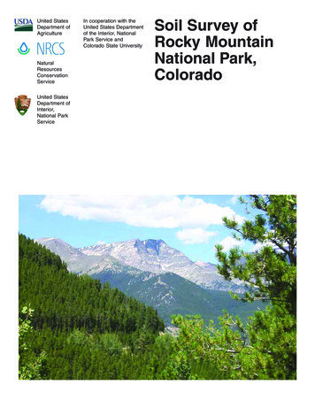
2This soil survey is a publication of the National Cooperative Soil Survey, a joint effortof the United States Department of Agriculture and other Federal agencies, Stateagencies including the Agricultural Experiment Stations, and local agencies. The NaturalResources Conservation Service (formerly the Soil Conservation Service) hasleadership for the Federal part of the National Cooperative Soil Survey.Major fieldwork for this soil survey was completed in 1998. Soil names anddescriptions were approved in 1999. Unless otherwise indicated, statements in thispublication refer to conditions in the survey area in 1998. This survey was madecooperatively by the Natural Resources Conservation Service; the United StatesDepartment of Interior, National Park Service; and Colorado State University. The surveyis part of the technical assistance furnished to the National Park Service.A small part of this soil survey was published in 1983 as a part of the Soil Survey ofGrand County Area, Colorado. That portion in Grand County (3,240 acres) is supersededby this soil survey.Soil maps in this survey may be copied without permission. Enlargement of thesemaps, however, could cause misunderstanding of the detail of mapping. If enlarged,maps do not show the small areas of contrasting soils that could have been shown at alarger scale.The United States Department of Agriculture (USDA) prohibits discrimination in all ofits programs on the basis of race, color, national origin, gender, religion, age, disability,political beliefs, sexual orientation, and marital or family status. (Not all prohibited basesapply to all programs.) Persons with disabilities who require alternative means forcommunication of program information (Braille, large print, audiotape, etc.) shouldcontact the USDA’s TARGET Center at 202-720-2600 (voice or TDD).To file a complaint of discrimination, write USDA, Director, Office of Civil Rights,Room 326W, Whitten Building, 14th and Independence Avenue SW, Washington, DC20250-9410, or call 202- 720-5964 (voice or TDD). USDA is an equal opportunity providerand employer.Cover: Mt. Ypsilon, center, is on map unit 33-Rock outcrop-Rubble land complex, 30 to200 percent slopes, in an Alpine Life Zone. Shown left of Mt. Ypsilon is map unit 43Trailridge-Mummy complex, 20 to 60 per cent slopes, in an Alpine Life Zone. Below Mt.Ypsilon is spruce-fir in map unit 45-Ypsilon gravelly coarse sand loam, 20 to 50 percentslopes, in a Subalpine Life Zone. The diagonal stand of lodgepole pine in the leftforeground is on map unit 26-Nanita extremely gravelly loamy coarse sand, 30 to 60percent slopes, in a Montane Life Zone.Additional information about the Nation’s natural resources is available onlinefrom the Natural Resources Conservation Service at http://www.nrcs.usda.gov.
3ContentsHow To Use This Soil Survey . 1Contents . 3Foreword . 7Soil Survey of Rocky Mountain National Park . 8General Nature of the Area . 8History of Rocky Mountain National Park . 9Climate . 11How This Survey Was Made . 12General Soil Map Units . 15Alpine Life Zone . 15Subalpine Life Zone . 16Montane Life Zone . 18Riparian Life Zone . 20Detailed Soil Map Units . 221—Archrock-Fallriver association, 15 to 50 percent slopes . 232—Archrock-Onahu-Rock outcrop complex, 10 to 75 percent slopes . 253—Bullwark-Catamount complex, 20 to 50 percent slopes . 274—Catamount gravelly coarse sandy loam, 5 to 20 percent slopes . 295—Catamount-Bullwark-Rock outcrop complex, 10 to 40 percent slopes . 306—Enentah very stony loam, 10 to 40 percent slopes . 327—Enentah-Rubble land complex, 25 to 70 percent slopes . 338—Fallriver gravelly sandy loam, 10 to 45 percent slopes . 349—Fallriver gravelly sandy loam, warm, 10 to 45 percent slopes . 3510—Fallriver-Hiamovi complex, 10 to 55 percent slopes . 3611—Fallriver-Rock outcrop complex, 30 to 70 percent slopes . 3912—Galuche-Rock outcrop complex, 20 to 90 percent slopes . 4013—Granile very gravelly coarse sandy loam, 30 to 60 percent slopes . 4214—Hiamovi-Rock outcrop complex, 5 to 40 percent slopes . 4315—Hiamovi-Rock outcrop complex, 15 to 80 percent slopes . 4416—Isolation gravelly sandy loam, 5 to 35 percent slopes . 4617—Kawuneeche loam, 0 to 1 percent slopes . 4718—Kawuneeche mucky peat, 0 to 4 percent slopes . 4919—Kawuneeche mucky peat, low precipitation, 0 to 1 percent slopes . 5020—Kawuneeche-Dystrocryepts complex, 1 to 15 percent slopes . 5121—Legault very gravelly sandy loam, 15 to 45 percent slopes . 5322—Lumpyridge gravelly coarse sandy loam, 1 to 6 percent slopes . 5423—Lumpyridge-Rofork complex, 3 to 15 percent slopes . 5524—Mummy extremely cobbly sandy loam, 20 to 50 percent slopes . 5725—Mummy gravelly sandy loam, 10 to 35 percent slopes . 5926—Nanita extremely gravelly loamy coarse sand, 30 to 60 percent slopes . 6027—Nanita very gravelly sandy loam, 1 to 15 percent slopes . 6128—Nanita very gravelly sandy loam, 10 to 60 percent slopes . 6229—Nanita-Rock outcrop complex, 10 to 40 percent slopes . 6330—Onahu-Terric Cryofibrists-Trailridge complex, 2 to 35 percent slopes . 6431—Peeler loam, 5 to 40 percent slopes . 67
432—Rock outcrop-Cathedral complex, 20 to 100 percent slopes . 6833—Rock outcrop-Rubble land complex, 30 to 200 percent slopes . 6934—Rock outcrop-Rubble land-Enentah complex, 40 to 200 percent slopes . 7135—Rofork-Chasmfalls complex, 5 to 35 percent slopes . 7336—Rofork-Isolation complex, 5 to 35 percent slopes . 7537—Rubble land, 20 to 65 percent slopes . 7738—Terric Cryofibrists, 0 to 2 percent slopes. 7739—Tileston very cobbly sandy loam, 10 to 40 percent slopes . 7840—Tonahutu very gravelly sandy loam, 15 to 30 percent slopes . 8041—Tonahutu very gravelly sandy loam, 30 to 50 percent slopes . 8142—Trailridge-Archrock complex, 10 to 40 percent slopes . 8243—Trailridge-Mummy complex, 20 to 60 percent slopes . 8444—Venable loam, 0 to 1 percent slopes . 8645—Ypsilon gravelly coarse sandy loam, 20 to 50 percent slopes . 8746—Water . 88Use and Management of the Soils . 90Interpretive Ratings . 90Rating Class Terms . 90Numerical Ratings . 90Land Capability Classification . 91Rangeland . 92Hydric Soils . 92Forest Management . 93Recreation . 95Engineering . 96Building Site Development . 97Sanitary Facilities . 98Engineering Index Properties . 101Physical Properties . 102Chemical Properties . 104Construction Materials . 105Soil Features . 106Water Features . 107Classification of the Soils . 109Soil Series and Their Morphology . 109Archrock Series . 110Bullwark Series . 111Catamount Series . 113Cathedral Series . 114Chasmfalls Series . 115Dystrocryepts . 117Enentah Series . 118Fallriver Series . 120Galuche Series . 122Granile Series . 123
5Hiamovi Series . 125Isolation Series . 126Kawuneeche Series . 128Legault Series . 130Lumpyridge Series . 132Mummy Series . 133Nanita Series . 135Onahu Series . 137Peeler Series . 139Rofork Series . 140Terric Cryofibrists . 142Tileston Series . 143Tonahutu Series . 145Trailridge Series . 147Venable Series . 149Ypsilon Series . 150Formation of the Soils . 153Parent Material . 153Climate . 155Living Organisms . 155Relief . 156Time . 157References . 158Glossary . 160Tables . 178Table 1.--Temperature and precipitation . 180Table 2.--Freeze dates in spring and fall . 182Table 2.--Freeze dates in spring and fall . 182Table 3.--Growing season . 183Table 4.--Acreage and proportionate extent of the soils . 184Table 5.--Nonirrigated landcapabilities by map unit component . 187Table 6.--Ecological sites and characteristic native vegetation . 191Table 7.--Hydric soils . 202Table 8.--Hazard of erosion and suitability for roads on forestland . 209Table 9.--Damage by fire and seedling mortality on forestland . 217Table 10.--Camp and picnic areas . 222Table 11.--Paths and trails . 228Table 12.--Dwellings and small commercial buildings . 233Table 13.--Roads and streets, shallow excavations, and lawns andlandscaping . 243Table 14.--Sewage disposal . 255Table 15.--Sanitary Landfills . 264Table 16.--Engineering properties . 275Table 17.--Physical soil properties . 301
6Table 18.--Chemical soil properties . 307Table 19.--Source of gravel and sand . 317Table 20.--Source of reclamation material, roadfill, and topsoil . 323Table 21.--Soil features . 335Table 22.--Water features . 338Table 23.--Taxonomic classification of the soils . 352Published 2006
7ForewordThis soil survey contains information that affects land use planning in this surveyarea. It contains predictions of soil behavior for selected land uses. The survey alsohighlights soil limitations, improvements needed to overcome the limitations, and theimpact of selected land uses on the environment.This soil survey is designed for many different users. Farmers, ranchers, foresters,and agronomists can use it to evaluate the potential of the soil and the managementneeded for maximum food and fiber production. Planners, community officials,engineers, developers, builders, and home buyers can use the survey to plan landuse, select sites for construction, and identify special practices needed to ensureproper performance. Conservationists, teachers, students, and specialists inrecreation, wildlife management, waste disposal, and pollution control can use thesurvey to help them understand, protect, and enhance the environment.Various land use regulations of Federal, State, and local governments may imposespecial restrictions on land use or land treatment. The information in this report isintended to identify soil properties that are used in making various land use or landtreatment decisions. Statements made in this report are intended to help the landusers identify and reduce the effects of soil limitations on various land uses. Thelandowner or user is responsible for identifying and complying with existing laws andregulations.Great differences in soil properties can occur within short distances. Some soilsare seasonally wet or subject to flooding. Some are shallow to bedrock. Some are toounstable to be used as a foundation for buildings or roads. Clayey or wet soils arepoorly suited to use as septic tank absorption fields. A high water table makes a soilpoorly suited to basements or underground installations.These and many other soil properties that affect land use are described in this soilsurvey. Broad areas of soils are shown on the general soil map. The location of eachsoil is shown on the detailed soil maps. Each soil in the survey area is described.Information on specific uses is given for each soil. Help in using this publication andadditional information are available at the local office of the Natural ResourcesConservation Service or the Cooperative Extension Service.Allen GreenState ConservationistNatural Resources Conservation Service
8Soil Survey of Rocky MountainNational Park, ColoradoBy Lee A. NeveFieldwork by Dave Alstatt, Jim Borchert, Jodi Boyce, Lee A. Neve, Michael Petersen,Nathan Storck, Melissa Trenchik, and Tim Wheeler, Natural Resources ConservationService; and Steve Blecker, Colorado State University.United States Department of Agriculture, Natural Resources Conservation Service,in cooperation withUnited States Department of Interior, National Park Service; and Colorado StateUniversityGeneral Nature of the AreaRocky Mountain National Park is located in the north central part of Colorado(fig.1). It covers a total area of 266,200 acres: 142,500 acres in Larimer County,98,100 acres in Grand County, and 25,600 acres in Boulder County.Figure 1.—Location of Rocky Mountain National Park in Colorado.
Rocky Mountain National Park, Colorado9The Park has a wide range of vegetation types, climates, and elevations. The soilsof the Alpine Life Zone have a very short frost-free period (10 to 30 days), littlevegetation (dominantly Bellardi bog sedge, alpine bluegrass, avens, and tuftedhairgrass) or no vegetation on the Rock outcrop and Rubble land. This zone rangesfrom 10,000 to 13,460 feet in elevation and receives 30 to 40 inches of precipitationper year.The soils in the Subalpine Life Zone have a slightly longer frost-free period (10 to50 days) and support subalpine-fir, Engelmann’s spruce, grouse whortleberry, Rosssedge, elk sedge, and heartleaf arnica. The Subalpine Life Zone ranges from 9,000to 12,000 feet in elevation and receives 24 to 40 inches of precipitation per year.The soils of the Montane Life Zone have a frost-free period of 40 to 100 days. Thiszone supports lodgepole pine, Rocky Mountain Douglas-fir, Engelmann’s spruce, elksedge, common juniper, kinnikinnick, and fivepetal cliffbush. The Montane Life Zoneranges from 8,000 to 10,000 feet in elevation and receives 16 to 24 inches ofprecipitation per year.The soils of the Riparian Life Zone have a frost-free period of 40 to 75 days andsupport tufted hairgrass, water sedge, alpine timothy, diamondleaf willow, andgrayleaf willow. The Riparian Life Zone ranges from 8,000 to 10,700 feet in elevationand receives 18 to 40 inches of precipitation per year.The soils in Rocky Mountain National Park range widely in texture, depth, andother characteristics. Soils in the Alpine Life Zone formed in gravelly slope alluvium,or residuum, colluvium, or till derived from granite, gneiss, or schist, are shallow andvery deep, and are somewhat excessively drained. The soils in the Subalpine LifeZone formed in colluvium, till, slope alluvium, or residuum derived from granite,gneiss, or schist, are very deep and shallow, and are somewhat excessively drained.The soils in the Montane Life Zone formed in sandy and gravelly till and in gravellyslope alluvium derived from granite, gneiss, and schist, are very deep and shallow,and are somewhat excessively drained. The soils in the Riparian Life Zone formed inalluvium derived from granite, gneiss, and schist, are very deep, and are poorly ormoderately well drained.None of the soils in the Park are considered to be prime farmland.History of Rocky Mountain National ParkEarly InhabitantsDuring the Ice Age when massive glaciers were grinding the landscape, shapingthe meadows and peaks, the area that would become Rocky Mountain National Parkwas an inhospitable land. It was not until some 11,000 years ago that humans beganventuring into these valleys and mountains.Native PeoplesSpearheads broken in the fury of a mammoth’s charge and scrapers discardedalong a nomad’s trail tell us little about the area’s early native peoples. We do knowthat even though it was never their year-round home, the green valleys, tundrameadows, and crystal lakes became favored summer hunting grounds for the Utetribe. In setting up their camps, they made use of the straight and slender lodgepolepine as tepee poles. Until the late 1700s, the Ute Indian Tribe controlled the mountainterritories.Tepee rings and other signs of summer camps were still evident by the time thefirst settlers arrived, but few vestiges of those times remain today, other than the largeriver boulders that Native Americans carried to the top of Oldman Mountain, a site oftheir ceremonial vision quests.
10Soil SurveyEarly Explorers and SettlersThe United States acquired the Park’s original 358.5 square miles in the hugeLouisiana Purchase of 1803. French trappers and the Spanish explorers before themseem to have skirted the current park boundaries in their wilderness forays. EvenMajor Stephen H. Long and his expedition forces avoided these rugged barricades in1820. Long was never closer than 40 miles to the peak named for him.Published in 1843, Scenes in the Rocky Mountains described the explorations ofRufus Sage from Connecticut. It was the first account of the area’s wonders to reachincredulous easterners. Sage spent four years roaming the Rockies, basing hisexplorations from Fort Lupton, north of present-day Denver. For a month, Sagehunted deer in the area now known as Estes Park.The first settler in the area was Joel Estes, a Kentuckian. Scouting for game onefall, he and his son climbed a high promontory that gave them a view of abreathtakingly beautiful valley. In 1860, Estes moved his family into a new home inthe area now known as Estes Park.Winters proved too harsh for cattle, so six years later the Estes family sold out fora yoke of oxen. The Estes cabin was soon converted into guest accommodations,and beginning in 1867 the number of visitors to this area grew steadily.A Mountain MeccaThe Rockies continued to attract the adventurous, including the great explorerJohn Wesley Powell, who conquered the summit of Longs Peak in 1868. Just fiveyears later, Anna Dickinson became the first woman to succeed in the climb.Isabella Bird, an Englishwoman whose extensive travels and writings earned herthe first female membership in the Royal Geographic Society, visited Estes Park inthe fall of 1873. Bird’s book, A Lady’s Life in the Rocky Mountains, attracted manypeople to the area, as did Frederick Chapin’s Mountaineering in Colorado.While much of the West was attracting homesteaders, the Rockies were alsobecoming established as a tourist mecca. By 1874, a stage line ran between EstesPark and Longmont by way of North Saint Vrain Canyon. About that time, an Englishearl, Lord Dunraven, arrived and laid questionable claim to 15,000 acres as hisprivate game preserve. He also built the fine Estes Park Hotel.Miners and HomesteadersBecause large veins of silver and gold had been discovered in other areas of theRockies, miners considered the area a land of opportunity and came in droves duringColorado’s gold rush of the late 1870s. Lulu City, in what is now the northwest part ofRocky Mountain National Park, was a booming mining town in 1880 with a raucousreputation. Three years later, it was nearly deserted because the region’s mineralriches were far less than the miners dreamed.When the miners and first settlers arrived, there seemed no end to the supply ofgame. Bear, deer, wolves, and elk were abundant. To feed the boom town demand,commercial hunters went to work: a single hunter could deliver a weekly supply ofthree tons of assorted big-game meat.The rousing boom times yielded to an industrious homesteading period. Ranchersand farmers felt that the real wealth of the Rockies lay in its water. They fought overrights to it (finally running the Earl of Dunraven out of town) and built ambitiouscanal systems to transfer water from the wetter western slopes to the drier easternplains. The Grand Ditch in the Never Summer Range in the Park intercepted thestream source of the Colorado River and diverted it for use for cattle and crops.Though homesteading proved no more profitable than mining in this land, anotherenterprise showed promise: dude ranches began attracting city dwellers in quest ofan original adventure.
Rocky Mountain National Park, Colorado11Protecting the RockiesIn 1903, F.O. Stanley, inventor of the Stanley Steamer automobile, came to EstesPark, Colorado for his health. Impressed by the beauty of the valley and grateful forthe improvement in his health, he decided to invest his money and his future there. In1909, he opened the elegant Stanley Hotel, a classic inn exemplifying the golden
This map is useful in planning the use and management of large areas. To find information about your area of interest, locate that area on the map, identify the name of the map unit in the area on the color-coded map legend, then refer to the section General Soil Map Units for a general


