Transcription
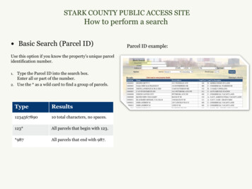
STARK COUNTY PUBLIC ACCESS SITEHow to perform a search Basic Search (Parcel ID)Use this option if you know the property’s unique parcelidentification number.Type the Parcel ID into the search box.Enter all or part of the number.2. Use the * as a wild card to find a group of parcels.1.TypeResults123456789010 total characters, no spaces.123*All parcels that begin with 123.*987All parcels that end with 987.Parcel ID example:
STARK COUNTY PUBLIC ACCESS SITEHow to perform a search Basic Search (Owner)Use this search option to locate properties with a knownowner name.Type in the full name or part of the full name into thesearch box (LastName FirstName without commas).2. Use the * as a wild card to match any string ofcharacters. A wild card is assumed at the end on anystring of characters.1.TypeResultsSmith JohnSmith JohnB*owBrown, Barlow, Below, etc.B*o*skiBojarski, Bronowski, Bukowski, etc.GrantGrant, Grantham, Grants, etc.Ownership example with partial name:
STARK COUNTY PUBLIC ACCESS SITEHow to perform a search Basic Search (Address)Use this search option to locate properties using a streetnumber, name or direction.1. For best results leave off the street suffix.2. Use the * as a wild card to match any string ofcharacters (when unsure of spelling or to return allresults on a particular street). A wild card is assumed atthe end on any string of characters.TypeResults819 Woodland819 WoodlandWoodlandAll addresses on a street with the nameWoodland in it:# Woodland Dr# Woodland Hills WayBa*All addresses on a street beginningwith “Bay”:# Bay Ct# Babbitz Ave# BaldwinAddress example with partial street name:
STARK COUNTY PUBLIC ACCESS SITEHow to perform a search Advanced SearchUse this option to perform searches with multiple criteria(at least one Criteria must be selected from one Group).In the Group drop-down box, select the desired group(Residential/Agricultural OR Commercial).2. In the Criteria drop-down box, select the desiredcriteria you want to search on.3. Once selected, a field(s) will appear below based onwhat you have chosen. You can enter your wording,dates, numbers, etc. Then click the Add button.4. The criteria will appear in the Current Search Criteria5.1.6.7.8.1box to the right.Select another criteria item, enter a value and repeatuntil you have entered what you need to build amulti-criteria search.Verify whether you entered the information correctly.If not, select the item in the Current search criteriabox that you need to change, then click the Editbutton to make your corrections. You MUST click onthe Add button again to make the change effective.If needed, use the Remove button to delete criteria.For multiple criteria search, enter values separated bya comma and without spaces (zip code enter:32301,32302,32308).233b4
STARK COUNTY PUBLIC ACCESS SITEHow to view property details Browsing Property DetailsOnce you perform a desired search, you may view detailsabout any of the properties in the Result grid. Select aproperty from your search results to view property recorddetails. A summary page (Profile) opens with variousdetails about the given parcel (Parcel, Owner,Tax Mailing Name and Address, Legal,Credits & Programs, Property Inspection/Reviews).1. Menu Options: on the left, provide additional recorddetails (Values, Appeal Tracking, Sales, Tax Summary,Land, sketch, maps etc.).Click any category to navigate to that level of detail.2. Record Navigation: on the right, allows you to viewother properties from your search results. Click thearrows to view the next or previous record in the list.You may also return to your search results by clicking“Return to Search Results” .2. RecordNavigation1. MenuOptions
STARK COUNTY PUBLIC ACCESS SITEAdditional property record features ActionsPrintable Summary: generates a printable summaryof the property’s “Summary” menu option.2. Printable Version: generates a printable version ofthe menu option that you are currently viewing.1.Actions
STARK COUNTY PUBLIC ACCESS SITEHow to perform a search Map SearchUse Basic or Advanced searches from the Property Record Menu to view the maps for a specific parcel.1. Once the parcel has been selected, navigate to the Maps menu on the left.1
STARK COUNTY PUBLIC ACCESS SITEHow to navigate the map Map DetailsThe map menu option displays a view of the selected parcel, with the parcel highlighted. The view can be adjusted using themap tools (hover your selection arrow over any button above the map to view a tooltip description). Map Tools12345The map tools are located across the top of the map image.1. Zoom In: Click and hold left mouse button then drag abox around the area you want to zoom in further.2. Zoom Out: Click and hold left mouse button then draga box around the area you want to zoom out further.3. Pan (move): Click and hold left mouse button on mapthen drag map (move) to desired location.4. Full extent: Click button to zoom to map of entirecounty.5. Back/Forward: Click left arrow to view previousselections. Click right arrow to view the most recentselections.6. Selection Display type: Click button to change theselected parcel display (choose polygons or points).7. Select: Click button, choose a method for selectingparcels on the map (freehand, point & box) from thepick list.6789101112138. Select and Zoom: Click button then select a parcel on9.10.11.12.13.the map to zoom in to.Identify: Click button then select a parcel on the mapto identify and return parcel details.Measure: Click to open dialog box. Selectmeasurement type (area, distance or point), selectformat, then follow instructions on screen.Print or Download: Left click button to open dialogbox, select format & size then click select print orexport. Click create map image button to execute. Ifcustom map is chosen, set map size in pixels.Full Screen: Click to open map in full screen mode.Map Contents: Opens map contents (layers) box if notalready open.
Print or Download: Left click button to open dialog box, select format & size then click select print or export. Click create map image button to execute. If custom map is chosen, set map size in pixels. 12. Full Screen: Click to open map in full screen mode. 13. Map Contents: Opens map contents (layers) box if not already open.