Transcription
This article was downloaded by: [Jiaojiao Tian]On: 15 July 2015, At: 05:42Publisher: Taylor & FrancisInforma Ltd Registered in England and Wales Registered Number: 1072954 Registeredoffice: 5 Howick Place, London, SW1P 1WGInternational Journal of RemoteSensingPublication details, including instructions for authors andsubscription patiotemporal inferences for use inbuilding detection using series of veryhigh-resolution space-borne stereoimagesabRongjun Qin , Jiaojiao Tian & Peter ReinartzbaFuture Cities Laboratory, Singapore-ETH Centre, 138602SingaporebClick for updatesGerman Aerospace Center (DLR), Remote Sensing TechnologyInstitute (IMF), 82234 Wessling, GermanyPublished online: 13 Jul 2015.To cite this article: Rongjun Qin, Jiaojiao Tian & Peter Reinartz (2015): Spatiotemporal inferencesfor use in building detection using series of very-high-resolution space-borne stereo images,International Journal of Remote Sensing, DOI: 10.1080/01431161.2015.1066527To link to this article: ASE SCROLL DOWN FOR ARTICLETaylor & Francis makes every effort to ensure the accuracy of all the information (the“Content”) contained in the publications on our platform. However, Taylor & Francis,our agents, and our licensors make no representations or warranties whatsoever as tothe accuracy, completeness, or suitability for any purpose of the Content. Any opinionsand views expressed in this publication are the opinions and views of the authors,and are not the views of or endorsed by Taylor & Francis. The accuracy of the Contentshould not be relied upon and should be independently verified with primary sourcesof information. Taylor and Francis shall not be liable for any losses, actions, claims,proceedings, demands, costs, expenses, damages, and other liabilities whatsoever orhowsoever caused arising directly or indirectly in connection with, in relation to or arisingout of the use of the Content.This article may be used for research, teaching, and private study purposes. Anysubstantial or systematic reproduction, redistribution, reselling, loan, sub-licensing,systematic supply, or distribution in any form to anyone is expressly forbidden. Terms &
Downloaded by [Jiaojiao Tian] at 05:42 15 July 2015Conditions of access and use can be found at s
International Journal of Remote Sensing, 7Spatiotemporal inferences for use in building detection using series ofvery-high-resolution space-borne stereo imagesRongjun Qina*, Jiaojiao Tianb, and Peter ReinartzbaFuture Cities Laboratory, Singapore-ETH Centre, 138602 Singapore; bGerman Aerospace Center(DLR), Remote Sensing Technology Institute (IMF), 82234 Wessling, GermanyDownloaded by [Jiaojiao Tian] at 05:42 15 July 2015(Received 30 December 2014; accepted 15 June 2015)Automatic building detection from very-high-resolution (VHR) satellite images is adifficult task. The detection accuracy is usually limited by spectral ambiguities and theuncertainties of the available height information. Feature extraction and trainingsampling collection for supervised methods are other sources of uncertainty. Mostwidely used VHR sensors have shorter revisit cycles (IKONOS/GeoEye-1/2, 3 days;WorldView 1/2, 1.1 days) due to large off-nadir viewing angles and hence are able toperform consistent acquisition of mono or stereo images. In this article, we investigatethe possibility of using high-temporal stereo VHR images to enhance remote-sensingimage interpretation under the context of building detection. Digital surface models,which contain the height information, are generated for each date using semi-globalmatching. Pre-classification is performed combining the height and spectral information to obtain an initial building probability map. With a reference land cover mapavailable for one date, the training samples of the other dates are automatically derivedusing a rule-based validating procedure. A spatiotemporal inference filter is developedconsidering the spectral, spatial, and temporal aspects to enhance the building probability maps. This aims at homogenizing the building probability values of spectrallysimilar pixels in the spatial domain and geometrically similar pixels in the temporaldomain, while being robust to the silhouette of the images and geometric discrepanciesof the multitemporal data. The effectiveness and robustness of the proposed method areevaluated by performing three experiments on six stereo pairs of the same region overa time period of five years (2006–2011). The area under curve (AUC) of the receiveroperating characteristic and kappa statistic (κ) are employed to assess the results. Theseexperiments show that spatiotemporal inference filtering largely improves the accuracyof the building probability map (average AUC 0.95) while facilitating buildingextraction in snow-covered images. The resulting building probability maps can befurther used for other applications (e.g. building footprint updating).1. Introduction1.1. BackgroundData interpretation of remote-sensing data is a major task for earth observation, and theaccurate identification and localization of buildings is essential for building analysis,planning, and urban growth monitoring. The development of very-high-resolution(VHR) optical images has paved a path to study building properties on a large scale(Qin, Gong, and Fan 2010; Qin et al. 2013). In particular, space-borne platforms carryingthese sensors usually have a short revisit time (e.g. IKONOS, 3.5 days; WorldView,1.1 days), giving them the potential to capture remote-sensing image time series.*Corresponding author. Email: rqin@studuent.ethz.ch 2015 Taylor & Francis
Downloaded by [Jiaojiao Tian] at 05:42 15 July 20152R. Qin et al.Moreover, advanced stereo matching algorithms (Gehrke et al. 2010; Gruen 2012;Hirschmüller 2008) have driven the incremental availability of digital surface models(DSMs) at relatively low cost, providing additional information for data interpretation,and are particularly useful for the identification of buildings (Qin and Fang 2014).Current building detection methods mainly work with data sets of one date, whilealgorithms are designed under the scenarios that (1) only a single multispectral image isavailable, (2) only the DSM is available, or (3) both image and DSM are available.Though efforts have been made to improve building feature delineation, detection strategies, and learning methods (Huang and Zhang 2011; Meng, Wang, and Currit 2009; Ok,Senaras, and Yuksel 2013; Sirmacek and Unsalan 2011), algorithmic limitations havebeen reached owning to the existence of uncertainties in DSMs and spectral ambiguitiesbetween buildings and other impervious objects such as roads and ground. Artefacts occurfor data captured under different acquisitions: humid surfaces (e.g. after rain) can lead tospecular reflections and the snow coverage of a scene will significantly reduce the spectralinformation of the images. Moreover, atmospheric and other unpredictable conditionsaffect the images, sometimes substantially reducing the quality of the matched DSMs(Hirschmüller and Scharstein 2009). However, current building detection algorithms arenot well enough advanced to interpret such complicated variations, which restricts theiroptimal performance to certain conditions.If time-intensive multitemporal data are available, their joint use via probabilityinference may tackle such ‘case-specific’ limitations for current building detection algorithms. Research on analysing low- to medium-resolution image sequences is mainlyaimed at pairwise change detection (Coppin et al. 2004) and visual analysis for independently interpreted results, such as vegetation and urban growth (Kastens and Legates2002). Correlations between different dates were analysed among the interpreted results,whereas multitemporal images were not used for mutual support in a joint interpretation.To the authors’ best knowledge, to date only a few studies have addressed the probabilityinferences of VHR images with high temporal resolution for joint data interpretation. Inthis article, we therefore propose a method to perform spatiotemporal inference onbuilding probability maps, adopting a three-dimensional (3D) bilateral filter to study thepossibility of enhancing data interpretation accuracy with time series of VHR stereoimages, including the derived DSMs.1.2. Related worksThis study investigates the performance improvement in regard to building detectionusing multitemporal VHR stereo images, which has rarely been done before. Our studyis closely related to the general topic of building detection and multitemporal analysis, andtherefore it is necessary to introduce the state-of-the-art techniques applied in these areas.1.2.1. Building detection methodBuilding detection methods have previously been intensively studied, mainly focusing onsingle images, DSMs, or combined ortho-images and DSMs. With the availability ofadvanced stereo matching algorithms, the current trend is to use both ortho-images andDSMs for building detection. Due to the availability of training procedures, these methodscan generally classified as either supervised or unsupervised.As buildings are usually seen as one type of off-terrain object, height information is amajor indicator in assessing their probability. The normalized DSM (nDSM) is commonly
Downloaded by [Jiaojiao Tian] at 05:42 15 July 2015International Journal of Remote Sensing3used to derive off-terrain objects with height thresholds, and can be generated either bysubtracting a given digital terrain model (DTM) from the derived DSM or from the DSMalone. For most unsupervised methods, spectral information is usually used for detectingvegetation and sharpening the boundary of buildings. Chen et al. (2012) proposed a stepwise method combining multispectral ortho-imagery and nDSM: the initial buildingsegments were obtained by truncating the nDSM and normalized difference vegetationindex (NDVI) with given thresholds, and the final building masks were generated withrule-based consideration of the region size and relational constraints between buildingsand trees. Grigillo, Kosmatin Fras, and Petrovič (2011) generated the initial buildingmasks in the same manner, but eliminated tree masks using the homogeneity feature(Zhang 1999) and NDVI. Qin and Fang (2014) proposed a hierarchical method to derivebuilding segments using morphological operations on DSM and NDVI, and they adoptedgraph cut optimization to refine building boundaries using multispectral images. (Lu,Trinder, and Kubik 2006) proposed using the Dempster–Shafer (Shafer 1976) algorithmfor fusing building probability values extracted from multispectral imagery and DSM.Tian and Reinartz (2013) computed a building probability map based on random forests(RF) classification, and they adopted panchromatic images to get sharper buildingboundaries.The advantage of unsupervised methods is their rapid computation and flexibility toallow intuitive implementation of prior knowledge for building mask refinement.However, threshold selection and parameter tuning may be based on a case-by-casefashion. The supervised method can deal with this problem more efficiently, as priorinformation is derived from the data per se. Methods involving binary classification(building and non-building) or land-cover classification have been intensively studied(Dópido et al. 2013; Lee, Shan, and Bethel 2003; Meng et al. 2012; Tuia et al. 2010;Turlapaty et al. 2012), with most of attention drawn to improvement in feature extractionand design of the classifier (Dópido et al. 2013; Qin 2014b). The resulting building classwas commonly used as the final output (Lu, Trinder, and Kubik 2006) or initial buildingmasks for further refinement (Rottensteiner et al. 2005). The recent trend in classificationinvolves the development of spatial features to improve their separability (Qin 2014b;Zhang et al. 2006). Classification accuracy can be further improved by incorporating theavailable height information (Huang, Zhang, and Gong 2011). Turker and San (2010)adopted the support vector machine (SVM) classifier (Wang 2005) to classify pansharpened images for building detection. Lee, Shan, and Bethel (2003) employed theiterative self-organizing data analysis (ISODATA) techniques algorithm to classifyIKONOS multispectral images, and then approximated the building class using shapeelements. For classification methods such as SVM and RF (Breiman 2001), the confidence in classification is usually provided for each class, which could be further used torefine building detection.1.2.2. Multitemporal image analysisOne of the major tasks in multitemporal analysis is to evaluate temporal evolution andchanges in the ground scene over time. Bitemporal data have usually been studied forchange detection (Akca et al. 2010; Qin 2014a; Tian, Cui, and Reinartz 2014), andmultitemporal time series images commonly used for studying urban or vegetation growthat a coarse level (Coppin et al. 2004; Lu et al. 2004). Kastens and Legates (2002) usedlow-spatial resolution time series as a means of assessing vegetation changes and highlighted sensitive areas for vegetation degradation. In their method, images in the time
Downloaded by [Jiaojiao Tian] at 05:42 15 July 20154R. Qin et al.series are used independently to compute statistics such as circular variance, which arecomputed for the data analysis. Petitjean, Inglada, and Gançarski (2012) proposed adynamic time warping (DTW) on high-temporal- but low-spatial-resolution images totackle the problem of irregular data sampling and pairwise comparison of time-seriessequences. Herold, Goldstein, and Clarke (2003) used a set of old aerial photographs andsome IKONOS images to model urban growth and change, under the scenario of modelling and studying the spatial constraints on urban growth.One prominent inference model is Markov random field analysis (MRF) (Blake et al.,2011), which posts similarity constraints on spatially and temporally neighbouring pixels/objects to propagate their probability. The MRF inference model has been widely used forchange detection applications (Crispell, Mundy, and Taubin 2012; Qin and Gruen 2014;Schindler and Dellaert 2010). Taneja, Ballan, and Pollefeys (2011) proposed a voxelbased method to infer change probability through a MRF framework, which implicitlyadopted a multi-matching model for sensing geometric discrepancies among data fromdifferent dates, and a similar method was described by Schindler and Dellaert (2010).However, the MRF inference model is substantially a global optimization method, whichincurs the problem of high computation load for pixel-wise calculation. Due to the localnature of the ground scene, it is more efficient to use non-global methods for inference.1.3. Proposed strategyDespite previous work on low-to-medium resolution multitemporal analysis, particularlyunder the context of change detection, little work has been done on the enhancement ofimage interpretation using VHR stereo data. In regard to improving the interpretationaccuracy for each date, most existing methods focus on interpreting urban/vegetationchanges from multitemporal data with no investigation on how these could contribute toeach other. Therefore we aim to close this gap: we first adopt the RF classification method(Breiman 2001) to derive the probability maps for data from each date, with the trainingsamples generated from a reference map of only one date. Then the resulting buildingprobability map of each date is updated using a 3D bilateral filter considering the spectral,spatial, and temporal information.2. Data preprocessingTo perform pixel-/object-wise processing of multitemporal stereo data, a key step is togenerate well co-registered DSM and ortho-images for all the dates. In this study we usedthe ‘Catena’ system at DLR (German Aerospace Center) (Krauß et al. 2013), whichimplicitly adopts a multi-image block adjustment for bias correction (Fraser and Hanley2003) of rational polynomial coefficients and semi-global matching (SGM) (Hirschmüller2005) for DSM generation. Bias correction was done using a large number of multimatching tie points to ensure accurate geometric alignment. SGM adopts a multi-pathdynamic programming to minimize cost function:E ðDÞ ¼X X XC p; Dp þP1 T jDp Dq j ¼ 1 þP2 T jDp Dq j 1 ;pq2Np(1)q2Npwhere D is the disparity map (a matrix) where the value of each pixel on this map gridcorresponds to the parallax in the epipolar images. Dp denotes the values of pixel p in map
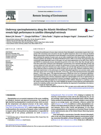
International Journal of Remote Sensing5grid D, and Np is a set of pixels neighbouring point p that follows an eight/fourconnectivity rule. The first of these terms denotes the matching cost of D, which isusually computed using census or mutual information cost (Hirschmüller 2005). Thesecond and third terms are the smoothing terms for disparity jumps of neighbouringpixels Np at one and more than one pixel, with P1 and P2 being the penalty. T ½ is aBoolean function that equals 1 when the expression holds true, and 0 otherwise. In ourexperiment, P1 ¼ 300; P2 ¼ 1000 were set empirically. The reader will find a detaileddescription of the algorithm and implementation in d'Angelo and Reinartz (2011) andHirschmüller (2005).Downloaded by [Jiaojiao Tian] at 05:42 15 July 20153. MethodologyIn this study the building probability maps are first generated using supervised classificationwith the multispectral ortho-image and DSM. The RF classifier is adopted to perform theclassification due to its low computational complexity and capability of handling largevolumes of data. For each test sample, it also provides a probability estimation of belongingto a particular class (Breiman 2001), which is descriptive for delineating building pixelsnumerically. With a land-cover reference map (hereafter referred as the reference map)available for one date of the time series, it is possible to derive the training samples for theother dates automatically. Our method is divided into three steps: (1) training samplegeneration; (2) feature extraction and classification; and (3) spatiotemporal inferenceusing a 3D bilateral filter. The first two steps are used to generate the building probabilitymap, where we present a step-wise automatic method to select training samples for eachdate. Our main contribution lies in the third step, where a 3D bilateral filter is proposed tolocally infer building probability values from the data of all dates.3.1. Training sample generationIn most cases the land-cover reference map is usually available in the geo-database, wherethe training samples for supervised classification are derived and with which the classification accuracy is assessed. However, the reference map may not be available for alldates. Our method requires reference data for only one date to derive training samples.Indeed, the reference map does not have to cover all the objects in the research region, butmust include typical ground objects for each class. Therefore, we propose to derive coarsereference maps from the available data for training sample generation. As our main focusin this study is buildings, we categorize the scene into the five following classes:‘building’, ‘ground’, ‘road’, ‘tree’, and ‘shadow’. By checking the consistency of DSMsand ortho-images, it is possible to verify existing and newly detected objects using changedetection techniques. It should be noted that this procedure is different from a normalchange detection process, as the verified and new objects do not need to be inclusiveproviding the generated coarse reference map is representative. Our proposed referencemap generation procedure is shown in Figure 1.As shown in Figure 1, the procedure of automatic reference generation is built on acoarse change detection procedure, and thus effective change indicators are very important.As shown in Figure 2, spectral variation due to seasonal differences can be very significantand employing spectral differences as a change indicator may cause much unnecessary error.Therefore, we use height difference as a robust measure and, being more specific, thedifference in nDSM, since that is inherently robust to small height shifts caused by data
6Downloaded by [Jiaojiao Tian] at 05:42 15 July 2015Figure 1.R. Qin et al.Flow chart for reference map generation.Figure 2. Examples of spectral changes across different seasons. Pan-sharpened IKONOS multispectral images (centre coordinate: 125 44ʹ E, 39 48ʹ N) of part of North Korea in summer (a) andin winter (b).co-registration. Building change usually induces a height difference, with the ground objectbeing its dual class. Therefore, buildings with height change will be eliminated from thereference map, as well as ground and roads. The nDSM in Figure 1 denotes an nDSMtruncated by NDVI, serving as a good indicator for buildings. One of the key characteristicsof shadow is its local luminance variance. We employ the morphological shadow index(MSI) as proposed by Huang and Zhang (2012) and Huang, Zhang, and Zhu (2013), whichadopts grey-level top-hat reconstruction from the inverse of the brightness image. As the MSIis linearly correlated to shadow, only a very small number of samples are needed for training.Since top-hat reconstruction eliminates a zero-order shift between MSIs for different dates,the new shadow pixels are extracted using a 5σ threshold, where σ is the standard deviationof the MSI of the reference shadow segments. Segments whose MSI is different to theshadow reference map by less than 5σ are kept as shadow candidates. Trees are jointlydetermined by nDSM and NDVI with a certain threshold. In our experiment, in the referencemap generation procedure (Figure 1) we take T1 ¼ 1:5; T2 ¼ 3, and T3 ¼ 0:2 as empiricalvalues, these being determined by the DSM co-registration quality of multispectral information. Training samples are randomly selected from the derived reference map for each date,and only 200 pixels per class are used for training.3.2. Feature extraction and classificationEarlier works have demonstrated that the combined use of spectral and height informationcan significantly improve data interpretation accuracy (Huang, Zhang, and Gong 2011).
International Journal of Remote Sensing7Height information is particularly useful in interpreting building properties. The RFclassifier is adopted in our experiment, due to its low computational cost and highclassification accuracy (Breiman 2001). Like other popular classifiers, RF provides aposteriori probability of the classification result belonging to a particular class, and theclass label is determined by selecting the one with maximal probability. As our intention isto derive building probability values, we adopt pixel-wise classification rather than objectbased strategy, which avoids pixels being diffused by erroneous segments.The following features are used for the classification task:Downloaded by [Jiaojiao Tian] at 05:42 15 July 2015(1) Principal component analysis (PCA) transformation of multispectral bands(2) Differential morphological profile (DMP) of the panchromatic images(3) Morphological top hat by reconstruction (MTHR) of the DSMPCA (Jolliffe 2005) is widely used for dimension reduction of high-dimensional features.Due to its nature of maximizing variance in each dimension, it usually provides higherseparability of different classes than the direct use of spectral information (Zhang et al.2006). MTHR is regarded as an efficient indicator for off-terrain objects (Qin 2014c; Qinand Fang 2014), and exhibits a good capability to separate spectrally similar classes suchas buildings and impervious ground. The MTHR of a DSM J (with its dimension beingmJ nJ ) can be computed asTeJ ¼ J BJ;εðJ;eÞ ;(2)where e is a structural element (with dimensions me me ), with ε being the grey-levelerosion operator:εðJ; eÞði; jÞ ¼ minfJðp a; q bÞj; eða; bÞ ¼ 1; 0 a; b me 1; 0 p; q mJ ; nJ g :(3)BJ;I is the grey-level morphology reconstruction of J from I, and in this case I is εðJ; eÞ.For more details on the use of grey-level morphological operation, the reader may refer toVincent (1993).DMP has been shown to be a valid spatial feature in improving classification accuracy(Benediktsson, Pesaresi, and Amason 2003). It adopts geodesic opening and closingoperations at different scales to build DMPs in order to represent the image structuralinformation, denoted asDMPJ;i ¼ BJ;εðJ;ei Þ BJ;εðJ;ei 1 Þ ;(4)where ei ; i ¼ 1; 2; . . . ; n, are the structural elements with different dimensions andDMPJ;i ; i ¼ 1; 2; . . . ; n, is the DMP feature sequence of a raster grid J, computed usingthe differentiations of grey-level morphological reconstruction with different structureelements ei . In our experiment, we use a disk-shaped structural element of varying radiusto build the DMP sequence. The radius ranges from 3 to 30 pixels (with an interval of 3pixels) to delineate ground objects.We employ a simple vector-stacking method to fuse these features. To render eachcomponent of the feature vector numerically equivalent for computation, the values ofeach dimension are normalized to the range [0, 1]. RF is used to perform the training and
8R. Qin et al.Downloaded by [Jiaojiao Tian] at 05:42 15 July 2015classification, with 500 trees initialized for the decision tree construction and testing, andthe output of this approach is a probability map for each class.3.3. Spatiotemporal inference using a 3D bilateral filterThe generated building probability maps vary with the data from different dates, due to theirspectral and height uncertainties. Therefore, for the building probability map of each date,artefacts can frequently occur. For example, ground is likely to be identified as buildingsunder snowfall, and the edge of the buildings might be noisy due to their highly similarspectrum to the ground. The matching algorithm may fail for certain small buildings owingto poor spectral quality, resulting in their incorrect identification. According to Pacifici,Longbotham, and Emery (2014), the spectral response of the same object from differentacquisitions can vary considerably, leading to different separability between urban classes.Our idea is to leverage the uncertainties by fusing building probability maps across alltemporal acquisitions using a simple and fast method, while avoiding the fusion processdiffused by data with large height discrepancies in the temporal direction.The bilateral filter is regarded as an edge-aware adaptive kernel filter that performsspatial filtering, weighting each pixel according to its spatial and spectral proximity to thecentric pixel for filtering (Tomasi and Manduchi 1998). It filters an image raster I(dimension mI nI ) as follows:kI ðx; yÞ ¼X ejjIðx;yÞ Iði;jÞjj2 jj½x;y ½i;j jj2þ2σ 22σ 212Iði; jÞ; 0 i; j mI ; nI ;(5)i;jwhere kI is the filtered raster. σ 1 and σ 2 are the spectral and spatial bandwidths,respectively, controlling the sensitivities of the spectral and spatial dissimilarities betweenthe centric and surrounding pixels. The spectral difference (Iðx; yÞ Iði; jÞ) is usuallycomputed as the Euclidean distance of the transformed colour space (e.g. CIELA; Jobloveand Greenberg 1978) or PCA). The filtering process assigns a large weight to spatiallyclose and spectrally similar pixels for filtering, while assigning a very small weight forpixels of varying spectral value.Considering the spatial correlation among pixels, a smoothness constraint can beposted on neighbouring pixels having similar spectral responses, aiming promote thehomogeneity of building probability values for locally similar pixels. The height information is robust in the temporal direction, so the homogeneity of the building probabilityvalues can be correlated to the height similarity in the temporal direction (Tian et al.2013). Based on these considerations, we further develop the 2D bilateral filter to a 3Dbilateral filter that implements the aforementioned constraints, and update the buildingprobability map of each date:Pf ðx; y; t Þ ¼ Pm¼xþlhX XX n¼yþl1wðm; n; k ÞPðm; n; t Þ;wðx; y; t Þ m¼x l n¼y l k¼1(6)where Pðm; n; t Þ is the raw building probability map at time t, with Pf ðx; y; t Þ being thefiltered results; l is the window length, which is usually the value of the spatialbandwidth; h is the number of temporal data sets; and wðm; n; k Þ is the 3D adaptivekernel used to compute the aggregated weight in the spatial and temporal directions:
International Journal of Remote Sensingwðm; n; k Þ ¼ w1 ðm; n; t Þw2 ðm; n; k; t Þ;9(7)wherew1 ðm; n; t Þ ¼ e LðIðx;y;t ÞÞ LðIðm;n;t ÞÞ2 jj½x;y ½m;n jj2þ2σ 22σ 212andDownloaded by [Jiaojiao Tian] at 05:42 15 July 2015w2 ðm; n; k; t Þ ¼ e jjHt ðm;nÞ Hk ðm;nÞjj22σ 23:(8)w1 ð Þ is the normal bilateral filter that considers the spatial smoothness; LðÞ representsthe colour transformation from RGB to CIELAB colour space; Hk represents the DSMat time k; w2 ð Þ is an extended part that constrains the height difference in the temporaldirection, with σ 3 being the temporal bandwidth; and w2 ð Þ assigns large weights forDSMs on dates of similar height while assigning a low value to those with large heightdifferences. It should be noted w2 ð Þ is constrained by weight w1 ð Þ in the spatialdomain. The kernel value will be still small if the spectral value is different from thatof the centric one, even with a similar height in temporal direction. This means that onlyspectrally similar pixels in the spatial domain and pixels of similar height in thetemporal domain will be used to contribute to the building probability values of thecentric pixels.The bandwidth values of the 3D bilateral filter are usually determined empiricallythrough trial-and-error approaches. These values are linearly rela
WorldView 1/2, 1.1 days) due to large off-nadir viewing angles and hence are able to perform consistent acquisition of mono or stereo images. In this article, we investigate the possibility of using high-temporal stereo VHR images to enhance remote-sensing image interpretation under t