Transcription
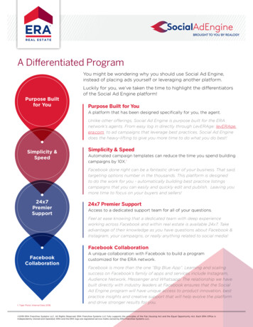
Public Access Landspage 276Township/RangeT31N, R18WT31N, R19WT32N, R18WT32N, R19WParts of Polk &St Croix counties205th Street192nd Street185th StreetHors e240th Streeti nttreet110th90th StreeteRivCCStrandLake200th AvenueN EW R I CH M O N D20964HatfieldLakeNew RichmondFlowageCroix Riversee page 252Boat RampParking AreaCities and VillagesSection LineCounty BoundaryCarry-In Boat RampState Land Purchased without KNSP FundsState Easement Purchased with KNSP FundsFederal LandState Easement Purchased without KNSP FundsPartner Lands Funded with KNSP Grants192nd Avenueoad93rd Street180th Avenue122ndS100th Street80th StreetSo m e r s e tCgh RSa45th StreettreetAppleFallsFlowagelAppRaleid40th StreetRoaLakeRice37thS210th AvenueTurtleLakeState Land Purchased with Knowles-NelsonStewardship Program (KNSP) FundsDNR LeaseSquawLake205th Avenueoadill RrdApple RiverCanyon StateNatural Areaenu220th AvenueMOldSt a r P ra i r i eeaRo50th StreetineIH118th StreetrMa232nd AvenueBassPine LakeLakeSt Croix IslandseAvWildlifeh8tArea20Local ParkPolk Saint Croix RoadSAIN T CR O IX CO U NT Y230th AvenueMinnesotaCedarLakePO LK CO U NT YnueStatewidePublicAccess115th StreetCounty Line AveMPaulsenSwede LakeLakePine LakeWest Church RoadLowerPineLake10th Avenue35e eRice LakekLeesee page 277LakeAliceSurpriseLaket276CrWindLakeChurchPine Lake35th Avenue200th Street20th AvenueceKLakeee220th Street23rd Avenue250th Street30th Avenue270th StreetR i v erS ai nt Croi xMcLeods SloughRiCrXMudLakeBigLakek50th Avenue40th AvenueNatural Area- Dedication210th StreetveDrierryIslandPleasant LakeLakeStree280th Street267thChOsceolaLake213th StreetStreet55th Avenue232Wisconsin Department of Natural Resourcesmore info at http://dnr.wi.gov/ keyword search "atlas"see page 299Osceola2765/26/20201County ForestSee Grant IndexShallow Water ShipwreckTownship Line0Internal DNR RoadState TrailSources: ESRI, StreetMap and other data providers. DISCLAIMER: No warranty, express or implied, is made regarding accuracy, completeness, or legality of the information herein.The boundaries depicted on this map may not represent the legal ownership boundaries of any property. The delineation of legal boundaries may only be conducted by a licensed surveyor.12Miles
page 277Township/RangeT31N, R16WT31N, R17WT32N, R16WT32N, R17W105th StreetState Easement Purchased with KNSP Funds195th Streetrooktreetw River235th StreetB63O260th Street180th Avenueusee page 253ry RBoat RampParking AreaCities and VillagesSection LineCounty BoundaryFederal LandState Easement Purchased without KNSP Funds240th StreetRuthWilloCarry-In Boat RampState Land Purchased without KNSP Funds205th AvenueerrkWildlife AreanDPartner Lands Funded with KNSP GrantsStatewideWildlifeHabitatFokcl a Cylon MarshHarminLakeCylonWildlifeAreaowSoGoose PondState Land Purchased with Knowles-NelsonStewardship Program (KNSP) Funds215th AvenueWill64ivB222nd Avenue220th Street210th Avenue65th StreetesDrivalleF125th Street130th Street220th Avenue200th StreetExtensiveWL Habitat190th Street145th StreetBoneLake5th AvenueDe e r Pa r k170th Street150th StreetOak RidgeLakeClearLa kesee page 278see page 27685th Street46HN EW R I CH M O N DDNR LeaseLongLakeSAIN T CR O IX CO U NT YTLocal ParkExtensiveWL HabitatPO LK CO U NT YCC200th Avenueew RichmondFlowageAClearLakeSnake Lake20th AvenueIsland Lake25th AvenueRem-SnakeCreek Spring70th StreetdScatteredWildlife235th AvenueHatfieldLake30th AvenueF250th StreetaRoSt a rP ra i r i eSouthFishLakek 50th AvenueFrenchLake100th StreetrchNorthFishLakeParker CreekFishery AreaWestern PrairieHabitatRestoration Area135th StreetuChstWe65Bull Broo35th AvenueCStatewide Spring PondsBlack BrookFlowage120th h AvenueTridentLakeLittl45th Avenuemenu140th StreeteAvDriveth40rBullBrookKing LakePP155tSwedeLakeApple RiveLincolnLakeAME Mansen Lake180th StreetChurchPineLakesee page 300KWindLakeWisconsin Department of Natural Resourcesmore info at http://dnr.wi.gov/ keyword search "atlas"215th SBigLake12/18/201975th StreetParts of Polk &St Croix counties90th StreetPublic Access LandsCounty ForestSee Grant IndexShallow Water ShipwreckTownship Line0Internal DNR RoadState TrailSources: ESRI, StreetMap and other data providers. DISCLAIMER: No warranty, express or implied, is made regarding accuracy, completeness, or legality of the information herein.The boundaries depicted on this map may not represent the legal ownership boundaries of any property. The delineation of legal boundaries may only be conducted by a licensed surveyor.12Miles
Public Access Landspage 278Township/RangeT31N, R14WT31N, R15WT32N, R14WT32N, R15WParts of Barron, Dunn,Polk & St Croix counties4th Street3 3/4 Street3 1/2 ntProgram1390th AvenueekBolenCreekFishery Area1240theAvenuyterue1270th h Avenue180th AvenueBushyLakesee page 254State Land Purchased with Knowles-NelsonStewardship Program (KNSP) FundsBoat RampParking AreaCities and VillagesSection LineCounty BoundaryCarry-In Boat RampState Land Purchased without KNSP FundsState Easement Purchased with KNSP FundsFederal LandState Easement Purchased without KNSP FundsPartner Lands Funded with KNSP Grantsk Hay Riv200th Avenue1330th Avenuetree205th AvenuehSCre170t290th StreetnForBeolth280th Streeteou210th Avenue128DNR Leasenc1370th Avenue64Local Parkth141010th StreetQRem-SouthFork HayRivereS270th Streetek220th Avenue310th StreetW o l f C reRem-TorgersonCreekP230th Avenue1/2 AvenureeSAINT CR O IX CO U NT YStn CreekBarron Dunn AvenueSAIN T CR O IX CO U NT YHarminLakePO LK CO U NT YCounty Line AvenueVa6th Street1st StreetBARR O N C O UN T YPO LK CO U NT Y30th Street40th Streetw Riverllo1st AvenueWi50th Street55th StreetA1County ForestSee Grant IndexShallow Water ShipwreckTownship Line0Internal DNR RoadState TrailSources: ESRI, StreetMap and other data providers. DISCLAIMER: No warranty, express or implied, is made regarding accuracy, completeness, or legality of the information herein.The boundaries depicted on this map may not represent the legal ownership boundaries of any property. The delineation of legal boundaries may only be conducted by a licensed surveyor.1see page 279see page 2773rd AvenueK10th Avenueoee kCr5th Street30th Avenue25th AvenueJsners CreekClear LakeGreek4 1/2 Avenue3 1/2 AvenuethClear LakeIce House LakeJac ker Cre4th Avenue14540th Avenue3rd StreetPolk-Barron Street45th Avenue63ScatteredWildlifeSilve5th AvenueDU NN CO U NT YFrenchLakeBassLakeLongLake15th StreetJJWisconsin Department of Natural Resourcesmore info at http://dnr.wi.gov/ keyword search "atlas"see page 30125th Street50th Avenue5/26/20202Milesk
Public Access Landspage 299Township/RangeT33N, R18WT33N, R19WT34N, R18WT34N, R19WPart of Polk County12/18/2019Wisconsin Department of Natural Resourcesmore info at http://dnr.wi.gov/ keyword search "atlas"see page 32287rRoadkBi248th StreetkOsceolaLakesee page 276State Land Purchased with Knowles-NelsonStewardship Program (KNSP) FundsState Easement Purchased with KNSP FundsPartner Lands Funded with KNSP GrantsLocal ParkDNR Lease1200th StreetSunshine Streettreet210th StreetCities and VillagesSection LineCounty BoundaryCounty ForestShallow Water Shipwreck195thSLittle Horseshoe Lake80th AvenueTownship LineDuckLakeRoundLakeStower SevenLakes State TrailBig60th AvenueParking AreaSee Grant IndexBehning CreekFisheryArea70th AvenueBoat RampFederal LandState Easement Purchased without KNSP Funds93rd AvenueePleasant LakeIsland LakeCarry-In Boat RampState Land Purchased without KNSP FundsenuBearLakeYHorseLake218th Street276276iveDrFMCreetiet240th Street223r120th Avenue110th laLittleRound RoundLake LakeSand LakeEast LakeFishery90thAAreav233DeerLakesee page 300eeke CrIceLakeeDrivnc243125th AvenueDresserOsceola HatcheryDuckLake64BarneysLakeriveRavine DScenic RiverLower LakeStatewide NonpointEasement ProgramPoplar Lake113th AvenueSaintCroix CloseSloughRiceLakeSPeasleeSaint Croix 100th AvenueLakeNational Wild andColeenTrulson LakeLakeJohnson LakeHawkinson LakeckproTraInterstatePark-IANSR150th Avenue140th Avenue220th Street8Lake O the DallesreBloomLakeGandy DancerState TrailST.CROI XFALLS20FolsomLake35208th StreetrR iveCroixSaintIce Age Trail95w160th Avenue257Wyckstrom LakeLongLakeC e n t u ri owageColby LakeLaIk Cre e kocRRive180th Street16LaveDrikeMudLake0Internal DNR RoadState TrailSources: ESRI, StreetMap and other data providers. DISCLAIMER: No warranty, express or implied, is made regarding accuracy, completeness, or legality of the information herein.The boundaries depicted on this map may not represent the legal ownership boundaries of any property. The delineation of legal boundaries may only be conducted by a licensed surveyor.1BigLake2Miles
Public Access Landspage 300Township/RangeT33N, R16WT33N, R17WT34N, R16WT34N, R17WPart of Polk County12/18/2019Wisconsin Department of Natural Resourcesmore info at http://dnr.wi.gov/ keyword search "atlas"see page 32314150th StreetBigLakekeeCrBakerAven85th StreetetPikeLakeNorthTwin Lake2497Cities and VillagesSection LineCounty BoundaryCounty ForestShallow Water ShipwreckTownship LineBrookBeaverBrook80th AvenueBLincolnLakeParking AreaFederal LandOmerLakeCattailStateTrailBoat RampSee Grant Index70th Street100th AvenueKingLakeCarry-In Boat Ramp1PalmerLakeiTrailAME RYTrident LakeState Easement Purchased without KNSP FundsuereStSouthTwin LakeKinneyLakesee page 277kBeaverayPPState Easement Purchased with KNSP FundsDNR Leaseh0t10Summerfield Lake65th AvenueState Land Purchased without KNSP FundsLocal ParkCeJim LakeGorresLake90th AvenuePark LakeBearTrapLakeState Land Purchased with Knowles-NelsonStewardship Program (KNSP) FundsPartner Lands Funded with KNSP h AvenuernidJoeLake138th StreetGooseLake70th AvenueVijobBure75th Streets amFueAven75thStowerSeven LakesState Trail143rd Street155th StreetHorseshoeLake110th AvenueGibsonLake105th AvenueC140th StreetLittleHorseshoeLake6572nd Street120th StreetB ra nc hSouth 150th StreetekreCbyTosee page 299Ba lLakeKenabeeBasswoodLakePineLakeMains Crossing AvenueOmerSpringsFishery Area102135th AvenueTwinLakessee page 301OxLakeBalsam BranchWildlife AreaCamp LakeTownlineLakeShilohLakeMarkee Spring120th AvenueKennedy Mill AvenueBeautifulLakeShilohFlowageCloverLake Apple RiverTimber DemoForest8BalsamBranchetBear orest LandWhite Ash LakeRivDeerLake145th Avenue110th140th AvenueLykens Lake153rd AvenueEastLakeApple160th Street150th AvenueueRice BedsCreekWildlife Area80th Street46LittleBass LakeWildGooseLakeParkerLake103rd Street170th StreetLovelessLake130th Street160th AvenueAven90th StreetPondSquareLake 165thBrullBullBrook60th Avenue0Internal DNR RoadState TrailSources: ESRI, StreetMap and other data providers. DISCLAIMER: No warranty, express or implied, is made regarding accuracy, completeness, or legality of the information herein.The boundaries depicted on this map may not represent the legal ownership boundaries of any property. The delineation of legal boundaries may only be conducted by a licensed surveyor.1ookJ65th StreetIFox CreekB a l sa mLa ke Mill108th StreetLongLaken t u ri aDriveBalsamLakeWest WhiteAshElkinsLake175th Avenue2Miles
page 301Township/RangeT33N, R14WT33N, R15WT34N, R14WT34N, R15W95th AvenueBeaverBrookNe90th Avenue40th Street45th StreetPaulson LakePP60th Avenue2 1/2 Street2nd Street6th Street6th AvenueState Land Purchased with Knowles-NelsonStewardship Program (KNSP) FundsreekSilver CBoat RampParking AreaCities and VillagesSection LineCounty BoundaryCarry-In Boat RampState Land Purchased without KNSP FundsState Easement Purchased with KNSP FundsFederal LandState Easement Purchased without KNSP FundsDNR Lease4th StreetBassLakeLongLakeLocal ParkTTurtle CreekFishery Areasee page 278Partner Lands Funded with KNSP Grants9th Avenue8th AvenueMudLakeGreeleyMarsh LakeLake65th Avenue10th AvenueCreekkClaytonMagnorLakeeektleooBarboLakeBig Moon LakeCrMusketLake10 1/2 AvenueurJBradKCamelia LakeCreeklldoAvenueake Ro11th AvenueLittle MoonLakeenBuBarboLpagg80th AvenueJJ85th63GilbertLake11 1/2 Avenueon23rd Street100th Avenue12 1/2 Avenue3rd Streetok105th AvenueLowerTurtleLake1 1/2 StreetaDSouth BranchBeaverBrook14th AvenueTu r t l e La k eAl men a14 1/2 AvenueOld Mill Pond1st StreetBeBroverCattailStateTrail35th StreetStatewideWildlifeHabitatPalmerLake125th Avenue25th Street115th Avenue135th AvenueExtensiveWL Habitat15th AvenueMo15th StreetJoel FlowageHillman LakeSkinawayElbow LakeLake16th Avenuesee page 302see page 3008Joel MarshWildlife AreaWest County Line Road140th AvenueDeedonLakeUpperTurtleLake1/2 Streetue150th AvenuePO LK CO U NT YChelstromLakeRem-UpperTurtle LakeBARR O N C O UN T Y33rd Street50th Street58th StreetBassLakeekSmithLakeeSilvSilverLakeGrassLake LittleHorseshoeLakeD rivCreeker LaEchoLakeHorseshoeLakeT17th Avenuetning158th Avenue138th AvenState Owned Islands160th Avenue155th AvenueTownlineLakeLoon LakeWildlifeAreaLighLittleRoundLake20th StreetSnakeLakeLoonLakeMudLakeTa i n t e r C r e e k178th AvenueUVCrystalLittleLakeHorseshoe Lake5 1/2 StreetApple RiverSugarbushLakeScatteredForest LandWisconsin Department of Natural Resourcesmore info at http://dnr.wi.gov/ keyword search "atlas"see page 324GloversLakeRiceBeds CreekWildlife Area12/18/20195th StreetParts of Barron &Polk counties4 1/2 StreetPublic Access Lands1County ForestSee Grant IndexShallow Water ShipwreckTownship Line0Internal DNR RoadState TrailSources: ESRI, StreetMap and other data providers. DISCLAIMER: No warranty, express or implied, is made regarding accuracy, completeness, or legality of the information herein.The boundaries depicted on this map may not represent the legal ownership boundaries of any property. The delineation of legal boundaries may only be conducted by a licensed surveyor.12Miles
Public Access Landspage 321Township/RangeT36N, R20WPart of Polk County12/18/2019Wisconsin Department of Natural Resourcesmore info at http://dnr.wi.gov/ keyword search "atlas"see page 343BUR NET T CO U NT YPO LK CO U NT Yoo290th AvenueeGovernor KnowlesState Foresteek310th StreetNin320th Streeter330th Streetmb340th StreetNu280th AvenueEvergreen Avenue300th StreetGCrchkreen CFishLakeseDitwaMudLakentyCoCou260th AvenueRatLakerryFeiveDrAvenandueScenic250th WildSaint Croix NationalRiversee page 322RrryFet Croix Riv ranchSunriseRiverDitchNumberSevSunrise RiverGrassLakeCounty16LongLakeState Land Purchased with Knowles-NelsonStewardship Program (KNSP) FundsState Easement Purchased with KNSP FundsDNR LeaseCities and VillagesSection LineCounty BoundaryFederal LandState Easement Purchased without KNSP FundsLocal ParkParking AreaCarry-In Boat RampState Land Purchased without KNSP FundsPartner Lands Funded with KNSP GrantsBoat Ramp1County ForestSee Grant IndexShallow Water ShipwreckTownship Line0Internal DNR RoadState TrailSources: ESRI, StreetMap and other data providers. DISCLAIMER: No warranty, express or implied, is made regarding accuracy, completeness, or legality of the information herein.The boundaries depicted on this map may not represent the legal ownership boundaries of any property. The delineation of legal boundaries may only be conducted by a licensed surveyor.12Miles
page 322Township/RangeT35N, R18WT35N, R19WT36N, R18WT36N, R19Wsee page 344enAvenreueBassLakeekDeerLakerveRieAlabama Lake- Island 2Twin Lake PublicAccess LaketownTarbert LakeHerby LakeNimon Lake260th Streetsee page 321SpringLaked230th Street215th Avenue190th Street250th StreetOtter Slide AvenueSaLegooLakeG215th StreetoarR200th AvenueMilltownBeede Lake TrailBeede LakeinMinnesota205th Street255th Streeteet256th StreRiv16240th AvenueLeesLake210th AvenueBig LakeeSandhillLakeClausonLake220th Avenuere260th AvenueN225th AvenueTLaket C265th AvenueEllofson LakeLittleMirrorLake230th AvenueManitouLakeNevers Dam Road RiceBogLakeKnifeLakeHoover Lake218th AvenueLakeTwin Lakesrnuivein Drsee page LakeHorseshoe LakeBBullheadLake275th Avenue270th AvenueSimpsonLake250th Avenue248th AvenuePineIslandLakeAlabama Lake StateHabitat AreantaMoukWol f CrgreMudLakeForsytheLake180th StreetEveGovernorKnowlesState ForestAlabama LakeGrandquist LakeWolf LakeRogerLakeLongTradeLake195th Streetve288th Avenue200th StreetRi285th AvenueFreedomLakes210th StreetTr aderOrrLake225th Street280th AvenueLonePineLake240th Street290th Avenue275th Street300th Street290th StreetPO LK CO U NT YRiceLakeGabrielsonLakeadBUR NET T CO U NT YWisconsin Department of Natural Resourcesmore info at http://dnr.wi.gov/ keyword search "atlas"TrPart of Polk County12/18/2019220th StreetPublic Access Landsrt CoixTuttleLake190th AvenueRive35r180th AvenueIndianheadFlowage see page 299State Land Purchased with Knowles-NelsonStewardship Program (KNSP) FundsState Easement Purchased with KNSP FundsDNR LeaseCities and VillagesSection LineCounty BoundaryFederal LandState Easement Purchased without KNSP FundsLocal ParkParking AreaCarry-In Boat RampState Land Purchased without KNSP FundsPartner Lands Funded with KNSP GrantsBoat Ramp1County ForestSee Grant IndexShallow Water ShipwreckTownship Line0Internal DNR RoadState TrailSources: ESRI, StreetMap and other data providers. DISCLAIMER: No warranty, express or implied, is made regarding accuracy, completeness, or legality of the information herein.The boundaries depicted on this map may not represent the legal ownership boundaries of any property. The delineation of legal boundaries may only be conducted by a licensed surveyor.12Miles
Public Access Landspage 323Township/RangeT35N, R16WT35N, R17WT36N, R16WT36N, R17WPart of Polk County12/18/2019Wisconsin Department of Natural Resourcesmore info at http://dnr.wi.gov/ keyword search "atlas"see page 345170th Street90th StreetBigRoundLakeBig Round AvenueBigBlakeLakeGHBunyan AvenueBoat RampParking AreaCities and VillagesSection LineCounty BoundaryCarry-In Boat RampState Easement Purchased with KNSP FundsFederal LandState Easement Purchased without KNSP Funds1ClaraLakeLittleBlakeLakeEsee page 300State Land Purchased without KNSP FundsHayLakeLost Lake70th Street155th StreetRem-Big Round LakeFootesLake80th Streetsee page 322145th Street160th Streetr175th StreetveBalsamLakeState Land Purchased with Knowles-NelsonStewardship Program (KNSP) FundsPartner Lands Funded with KNSP GrantsLakeEvelynRieekekRoadhtTwenty-NinthLakeak eigredLPickerel Lake BassLakeMullinsLakesee page 324Rounrater CreekCDepotLakeeStOtHalfMoonLake200th AvenueB a l sa m L a k eDNR LeaseAvenuKennyLake46cePineLakeRhinstadLakeLamont LakeVincentLakeBoneLakeElkins LakeLocal Park95th Streett CreekStateOwned IslandsDau RoadRiDahl LakeekrnuGGAntlerLakeLittlePineLakeCreteAntler Lake DrivekMcKenzie LakeWardLakeBigLake220th AvenueRiceLakeie CreeState Highway 48128FoxutI235th AvenueLittlePine LakeEastLakeLongLakeJohnsonLake250thRem-Bone Lakeenz265th Avenue35Milltown190th AvenueewaMallardLakeMurdock Lake230th AvenueGandy DancerState TrailCampDouglasLakepChipilTraTula LakeMcKenzie CreekWildlife AreaLittleOWard Lake48255th AvenueBig Butternut LakeLittleButternutLake210th AvenueMcK285th Avenue257Lu c k240th AvenueMargaret LakeLongLakeNCrooked LakeMarsh Lake290th AvenueStraight LakeeH ard r CrB260th Avenue270th Avenue163rd StreetB135th Street275th Avenue140th Street280th AvenueBosakLakeekSomers CreStraight RiverWildlife AreaIceAgeTrailWest Bone Lake Driveeer120th Streetadiv150th StreetTrR130th Street293rd Avenue110th StreetFredericTower Site61st StreetFr e d e r i cCounty ForestSee Grant IndexShallow Water ShipwreckTownship Line0Internal DNR RoadState TrailSources: ESRI, StreetMap and other data providers. DISCLAIMER: No warranty, express or implied, is made regarding accuracy, completeness, or legality of the information herein.The
Ice Age Trail Behning Creek Fishery Area Stow er v n L ak es S t Tr il Interstate Park-IANSR Gandy Dancer State Trail O sceola Hatchery Statewide Nonpoint Easement Program East Lake Fi hery Area 8 243 35 95 87 Mi nesota I M 20 Y 16 MM F S 2 2 0 t h S t r e e t 2 0 8 t h r S t r t Ri v er R o a d 93rd Av enu 9