Transcription
Pyramid Thin ProjectSpecialist Report for HydrologyContributors: Joni D. Brazier, HydrologistConnie Risley, HydrologistDate: February 11, 2009March 7, 20082003IntroductionThe Pyramid Thin Project proposes to commercially thin 351 acres of timber within matrix-allocatedstands on the Gold Beach Ranger District of the Rogue River–Siskiyou National Forest. Proposedtreatment areas are located in Township 37 South; Range 13 West; Sections 17, 19, 20, 29, 30, and 31;and Township 38 South; Range 13 West; Section 6; Willamette Meridian Curry County, Oregon. Forthis report, the analysis area is defined as the 6th field watersheds with treatment areas identified in theProposed Action on the Gold Beach Ranger District.Affected EnvironmentWatershed OverviewWatershed analyses were completed on the Pistol River Watershed in 2003 (David Evans and Associates2003) and the Hunter Creek Watershed in 1998 (EA Engineering 1998). These documents were reviewedfor this analysis and are incorporated by reference.The Pyramid Thin Project treatment areas are located within two 5th field and three 6th field watersheds inthe Chetco River Sub-basin (Table 1). Watershed boundaries and acreages in this report are based uponthe most up-to-date U.S. Geological Survey watershed delineations in GIS. These new watersheddelineations vary somewhat from those in the two watershed analyses, but the biggest difference is thechange to 6th field watersheds, where some original 6th fields were combined. However, the discussion ofwatershed conditions is still relevant – there may just be differences in calculations based on acreages ofparticular areas. Neither the Pistol River nor Hunter Creek watersheds are designated as Key Watersheds.Table 1. Pyramid Thin Project Watersheds. Acres of proposed treatments are the areas wheredensity management activities would occur.4th Field &5th Field &6th Field & Name6th FieldAcres ProposedNameNameAcresTreatments04 Pistol River02 North Fork Pistol River19,2272771710031201 Upper Hunter Creek12,3801Chetco River05 Hunter Creek02 Lower Hunter Creek16,08833In addition to the acres of proposed treatments, the Pyramid Thin Project also involves road maintenancealong the haul routes, 3 culvert replacements, and one culvert installation on Forest Roads 1703 and1703190. The two culvert replacements and one culvert installation on FSR 1703 is within the LowerHunter Creek 6th field watershed on tributary drainages to Big South Fork Hunter Creek. The culvertreplacement on FSR 1703.190 is within the North Fork Pistol River 6th field watershed, on the upper endof a small tributary drainage to the North Fork Pistol River.Supplementary Analysis ReportPyramid Thin ProjectHydrology ReportPage 1
Elevations in the Pistol River watershed range from sea level to 4,220 feet on Snow Camp Mountain; inthe Hunter Creek watershed from sea level to 3,558 feet on Sugarloaf Mountain. Elevations in theproposed harvest areas range from approximately 1,800 feet to 2,800 feet, with an average annualprecipitation of 115 to 120 inches. Most precipitation arrives from October through April, with themonths of May through September typically receiving less than 10 inches.The transient snow zone, as identified in the Pistol River Watershed Analysis, Version 2.0 (David Evansand Associates 2003) falls roughly between 2,800 and 4,000 feet in elevation. Transient snow zone refersto the elevation break where rain-on-snow events most often occur. Treatment areas for the Pyramid ThinProject are at the low end to just outside this identified transient snow zone; however, this range(particularly the low end) can vary from year to year depending on the winter’s storm patterns. Forexample the winter of 2007/2008 experienced several storms with snow levels approaching 1,000 to 1,500feet.Management HistoryThe two watersheds have similar ownerships and management histories. Approximately 55 percent of thePistol and 40 percent of the Hunter watersheds are federally managed. This public land is in the upperwatersheds. Most of the lower watersheds is owned by private timber companies and managed for timberharvest. The flat lands surrounding the estuaries and lower stream banks are agricultural and residential.A survey of historical aerial photos in the National Forest portion of the watershed shows that roads wereconstructed to fire lookouts on Wildhorse and Snow Camp prior to the 1940 photos. The routes went upthe Pistol River, along the ridge near Pyramid Rock (through the proposed Pyramid Thin harvest units) onthe route of present day Roads 1703 and 1503. Timber harvesting began in the watersheds in the late1940s on privately owned land, and on National Forest land in the late 1950s.Mineral exploration began in the Red Flats area after World War II. The primary mineral sought waschromium associated with the ultramafic rocks. The straight, parallel trenches left by these explorationsare visible on aerial photos. Some of the trenches have altered drainage patterns, but these alterations areminor, and no restoration needs have been noted.StreamflowNeither the Pistol River nor Hunter Creek have any dams or impoundments. Permits to withdraw smallamounts of water for domestic and irrigation use are held in the lower portions of the watersheds, outsidethe National Forest boundary (Pistol WA, p. 15). Neither stream has a gage in current use.The gage that most nearly reflects flow patterns in these two streams is USGS gage 14400000 on theChetco River. The Oregon Water Resources Department measures summer flows in Pistol and Hunter onan irregular basis.Effects of Prior Management ActivitiesIn order to address the question of whether past management activities have altered peakflow processes inthe watersheds, the Pistol River and Hunter Creek WA’s used the equivalent clearcut methodology (ECA)to determine hydrologic recovery. This method is explained in detail in the WAs, and takes into accountsuch influences as vegetation structure, stand age and harvest activity, agriculture and development, androads.Supplementary Analysis ReportPyramid Thin ProjectHydrology ReportPage 2
The Pistol River WA evaluated the effects of prior harvest and road construction on hydrologic processeswithin the National Forest portion of the watershed, and found that 96 percent of the North Fork Pistol,and 96 percent of the Sunrise Area, is in a state of natural condition or recovered. The North Fork Pistoland Sunrise Area Subwatersheds identified in the watershed analysis have since been combined into theNorth Fork Pistol 6th field watershed. Currently alterations to the hydrograph are unlikely due to theseconditions, and cumulative hydrologic effects at the watershed scale are uncertain but unlikely (DavidEvans and Associates 2003).Road densities in the North Fork Pistol 6th field watershed, based on most-up-to-date GIS information, are2.27 mi/mi2, placing it at functioning-at-risk based on National Marine Fisheries Service criteria(discussed in the WA).The Hunter Creek WA ECA calculations included all ownerships, and found that 85 percent of HunterCreek and 86 percent of North Fork Hunter Creek were hydrologically recovered or natural. These twowatersheds have since been combined into the Upper Hunter Creek 6th field watershed. In addition, 73percent of Big South Fork, and 83 percent of Lower Hunter Creek were hydrologically recovered ornatural. These two watersheds have since been combined into the Lower Hunter Creek 6th fieldwatershed. The Hunter Creek WA broke the analysis discussion into smaller watershed analysis areas(WAAs). The WAAs within the Pyramid Thin Project area activities (including culvert work) includes:06M04F, 06S02W, and 06S. WAA 06M04F (83% recovered) would have 1 acre of density managementtreatments; 06S02W (66% recovered) would have 51 acres of density mangament treatments; 06S (86%recovered) only involves culvert work.Road densities in the Upper Hunter Creek 6th field watershed are 2.12 mi/mi2 (funtioning-at-risk), and are3.87 mi/mi2 in the Lower Hunter Creek 6th field watershed (not properly functioning), based on most-upto-date GIS information.Channel MorphologyThe Pistol River and Hunter Creek Watershed Analyses characterized stream channels as source,transport, or response reaches, based on stream gradient. Source reaches (over 30 percent gradient) arefirst and second order channels and colluvial hollows, located in the uppermost reaches of the watersheds.They are generally considered vulnerable to scouring events such as debris flows and shallow landslides.However, field observations in Hunter Creek reported in the WA found these reaches to be stable, in bothharvested units and fully vegetated stands, with localized scouring.Supplementary Analysis ReportPyramid Thin ProjectHydrology ReportPage 3
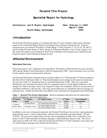
Figure 1. Map of streams that were surveyed and GPS’d. Majority of systems are intermittent.000113181716230 22717031909T 37.0 S - R 13.0 W302901503F or!2839rt h25!LL-9(17030 00No2715030328T 37.0 S - R 14.0 Wk P is t ol Rive 3341503037Fork31150303036031 2170H unterCreek13!LL-13(!!1703(!SL-130110106050403T 38.0 S - R 13.0 W17031 02T 38.0 S - R 14.0 W1703411Stream SurveysPyramid Units 20088131 0Temporary Roads31017017007170310012090801611010(!Heli Landings0RoadsStreams00.250.5Supplementary Analysis ReportPyramid Thin Project11.5Hydrology Report2Miles/Page 4
Transport reaches (3 to 30 percent gradient) dominate the perennial stream networks, with inclusions ofresponse reaches (less than 3% gradient). Field observations in North Fork Pistol and upper Hunter Creekhave found these characterizations to be accurate. Hunter Creek has large inner gorge landslides in theperidotite canyon; North Fork Pistol has localized areas of inner gorge instability.In the project area, the locations of all intermittent streams, and the few perennial streams adjacent toproposed treatment units, were located and mapped with GPS equipment (Figure 1). Channelcharacteristics were noted during this process. Larger streams downstream of the project area were spotchecked; the watershed analyses incorporated stream survey data on fish-bearing reaches.The geomorphology of the area has irregular slopes, in both steepness and aspect. Intermittent streamchannels characteristically form in steeper areas, disperse and disappear in flatter topography, then formagain as slopes increase. Where channels are well-developed, they tend to be downcutting in deep soilsand shallow in rocky areas. The inner gorges that slope down to the stream banks appear stable and wellvegetated.Riparian ReservesReference ConditionsRiver valley morphology for nearly all channel segments in the Pistol River and Hunter Creek watershedsis classified as confined. This confinement limited floodplain development. Consequently, riparianspecies (willows, sedges etc.) that depend on fine fluvial sediment deposits for establishment were fewand limited to the stream margins. Based on 1940 aerial photographs and field visits to undisturbedriparian zones in the North Fork Pistol and Hunter Creek, riparian zones on perennial streams weredominated by conifer species which provided a full canopy. Many of these stands had an understorycomponent of hardwood species. Due to a dominant component of conifers and a full canopy reducingsolar radiation input, streamside shade and large woody debris (LWD) recruitment potential were high.The inner gorge area along the mainstem of Hunter Creek, near Pine Point, had a reduced conifer andvegetative component. Low productivity soil of peridotites along the inner gorge of Hunter Creeksupported a minimal canopy cover (less than 30 percent) with an open understory. One reach of the innergorge is void of vegetation due to constant erosion.Management HistoryHarvest on National Forest land in the watersheds began in 1955. During the late 1950s and early 1960sharvest practices included clearcutting riparian areas. During the period from 1980 to 1989, narrowriparian buffers on perennial streams were usually left uncut or partially cut, but harvest practicesincluded stream cleanout, removing large wood from channels. The Northwest Forest Plan of 1994implemented Standards and Guidelines for Riparian Reserves, but no regeneration harvest has taken placeon National Forest land in these watersheds since then.Perennial StreamsPerennial streams and adjacent riparian areas are generally the most biologically diverse locations in thewatershed. Terrestrial species utilize the dense riparian vegetation as a travel and dispersal corridor. Thegrasses, shrubs, and hardwoods within the riparian zone provide an important food source for bothterrestrial and aquatic species. Due to relatively high moisture content and a multiple canopy ofhardwoods and conifers, these riparian areas provide thermal refuge in times of heat and drought. Thestreamside vegetation also provides a microclimate for riparian dependent species such as salamandersand frogs.Supplementary Analysis ReportPyramid Thin ProjectHydrology ReportPage 5
Perennial streams in the three sixth field watersheds lie outside the proposed treatment areas. The fewperennial streams in the vicinity of treatment areas are small and fed by ridgetop springs and seeps. Theriparian microsites associated with them tend to be narrow, some with dense undergrowth such as salal,and others with azalea and darlingtonia.Intermittent StreamsThe NWFP ROD defines intermittent channels as any nonpermanent flowing drainage feature having adefinable channel and evidence of annual scour or deposition. Intermittent channels often provide moistmicroclimates for amphibian species seeking shelter and nest sites, and for terrestrial species seekingthermal refuge and travel corridors. Intermittent channels also act as a conveyance system, deliveringsediment and nutrients to perennial fish bearing streams. Riparian zones play a major role in regulatingnutrient and energy flow in low-order streams.Streams in the vicinity of the proposed treatment areas usually begin as small, spatially intermittentephemeral channels. As they continue downhill they often vary in depth, first eroding a channel an inchor two in depth, then disappearing with no evidence of scour or deposition, then eroding a channel up toseveral feet deep, then dispersing over a flat area and disappearing again, before forming a continuouschannel.Vegetation adjacent to most segments of intermittent channels, as well as further out in their RiparianReserves, is indistinguishable from the upslope vegetation: Douglas fir, Jeffrey pine, knobcone pine,incense cedar, Port-Orford-cedar, hardwoods including tanoak, madrone, and canyon live oak, withscattered salal and swordfern. In summer and fall when channels are dry, banks and bottoms are also dry,with no cool or moist microsites. Rarely, a short stretch of intermittent stream channel is discovered withdamp banks, green grasses, or small puddles. Where these microsite locations are found, the cooler,moister conditions do not extend beyond the stream banks up into the inner gorge. These dry conditionslimit the extent to which intermittent streams around the treatment areas contribute to the processesdescribed above.Meadows are scattered throughout the general area. Intermittently flowing channels in these meadowsprovide nutrient diversity to the streams in this otherwise forested landscape.Hyporheic Areas and WetlandsBedrock and hillslope confinement limit the extent of hyporheic areas in most of the terrain in and aroundproposed treatment areas. However, irregular topography and ultramafic soils have created severalwetlands. Along the ridge separating Pistol from Hunter are several pond-like seasonally wet areascovered with azalea. Further down the slope in the North Fork Pistol, small poorly-defined intermittentstreams flow through flat, open meadowy areas. Rushes and willows indicate seasonally wet portions ofsome of these meadows. Where well-defined intermittent streams flow across flat areas, there areoccasional side channels, floodplains, well-developed riparian microsites, and opportunities for hyporheicflow.Canopy CoverThe Pistol River WA identified 38 percent mature and old-growth forest, 23 percent “young” and 38percent seed-sapling-pole sized trees within the North Fork Pistol Riparian Reserves (perennial streamsonly). In the vicinity of the Pyramid Thin proposed treatment areas, approximately 10 percent of the 515acres of intermittent stream Riparian Reserves (both Pistol and Hunter watersheds) are in previouslyharvested areas. The remaining 90 percent is primarily young to mature conifers, with open and sparselyvegetated serpentine areas.Supplementary Analysis ReportPyramid Thin ProjectHydrology ReportPage 6
The Hunter Creek Watershed Analysis found that the biggest concern within the riparian zone is the lackof large tree structure. The existing large tree structure does not, and is not expected to for the next 50years, provide adequate large wood recruitment into the channel environment. Lack of large treestructure has also reduced habitat connectivity and species diversity.Large Wood RecruitmentThe upper Hunter Creek channel is lacking large wood, probably because of prior timber harvest andchannel cleanout practices. Additionally, past riparian harvest has reduced the potential for large woodrecruitment. This reduction in large wood has removed the structure that would characteristically createpool-riffle morphology in channels with these gradients. The channel is left with a uniform gradient andlong, nearly continuous riffles. Downstream of the harvested area is the peridotite canyon, with rockyultramafic soils that support very little vegetation.In the North Fork Pistol, the steepness of the inner gorge made harvest of the trees immediately adjacentto the stream banks difficult. Although the strip of large trees is less than one site potential tree height inwidth in many areas, the quantity of future large wood has been only moderately diminished.Sediment Delivery ProcessesThe Pistol River WA and Hunter Creek WA identify mass movement as the primary source of sedimentdelivery to streams prior to management activities; with minor contributions from surface erosion andravel, primarily on ultramafic soils or after catastrophic fires. Pyramid Thin Project proposed treatmentareas lie over geologic formations where natural landslide activity tends to be small slides typicallyconcentrated in inner gorges and stream adjacent sideslopes and drainage headwalls (Refer to the Geologyand Soils Report for more details).Effects of prior management activitiesIncreases in mass failures following timber harvest and road construction were documented in the PistolRiver Study (Russell 1994, cited in Evans and Associates 2003). Early tractor harvest may have added tothe surface erosion. Contributions to sediment delivery have decreased following changes in forestpractices in the 1980s and 1990s. Surface erosion from road cuts and fillslopes continues to occur, as doroad related failures, but these are minor contributors to the sediment regime.Water QualitySeveral streams in the 6th field watersheds associated with the Pyramid Thin Project treatment areas andassociated actions are considered water quality limited by the Oregon Department of EnvironmentalQuality (ODEQ) and are on the 303(d) list in the 2004/2006 Integrated Report. Table 2 identifies thestreams that are listed as Category 5 water quality limited, the parameters for which they are listed, andthe beneficial uses that are protected by the pollutant standard.Supplementary Analysis ReportPyramid Thin ProjectHydrology ReportPage 7
Table 2. Water Quality Limited Streams. Includes streams within the North Fork Pistol River, UpperHunter Creek, and Lower Hunter Creek 6th field watersheds.Stream /ParameterSeasonBeneficial UsesRiver MileHunter Creek
The Pyramid Thin Project treatment areas are located within two 5th field and three 6th field watersheds in the Chetco River Sub-basin (Table 1). Watershed boundaries and acreages in this report are based upon the most up-to-date U.S. Geological