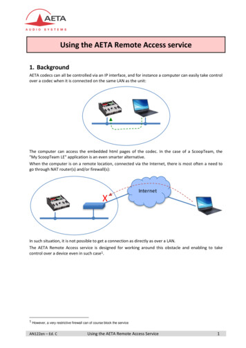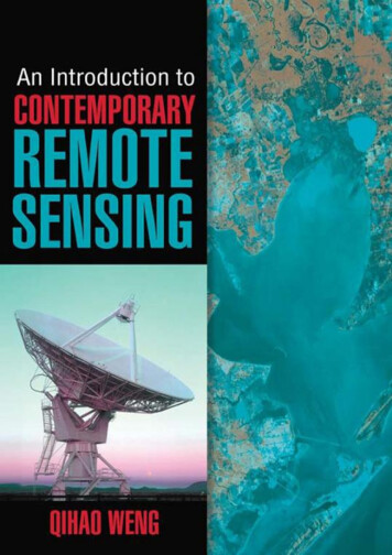
Transcription
An Introduction to Contemporary Remote Sensing2
About the AuthorDr. Qihao Weng is a professor of geography and the director of the Center for Urban and EnvironmentalChange at Indiana State University. He is also a guest/adjunct professor at Peking University, Beijing NormalUniversity, Wuhan University, and Fujian Normal University, and a guest research scientist at the BeijingMeteorological Bureau. His research focuses on remote sensing and GIS analysis of urban ecological andenvironmental systems, land-use and land-cover change, urbanization impacts, and human-environmentinteractions. Dr. Weng is the author of more than 130 peer-reviewed journal articles and other publicationsand 4 books. He has received a number of awards, including the Outstanding Contributions Award inRemote Sensing from the American Association of Geographers (AAG) Remote Sensing Specialty Group(2011), the Erdas Award for Best Scientific Paper in Remote Sensing from the American Society forPhotogrammetry and Remote Sensing (ASPRS) (2010), a NASA Senior Fellowship (2009), and theTheodore Dreiser Distinguished Research Award from Indiana State University (2006). Dr. Weng hasworked extensively with optical and thermal remote sensing data, and his projects have been funded by NSF,NASA, USGS, USAID, NOAA, the National Geographic Society, and the Indiana Department of NaturalResources. At Indiana State, he teaches courses on remote sensing, digital image processing, remote sensing–GIS integration, and GIS and environmental modeling, and has mentored 10 doctoral and 7 mastersstudents. Dr. Weng has served as a national director of ASPRS (2007–2010), chair of the AAG ChinaGeography Specialty Group (2010–2011), and a member of the U.S. Department of Energy’s Cool RoofsRoadmap and Strategy Review Panel (2010). Currently, he is an associate editor of the ISPRS Journal ofPhotogrammetry and Remote Sensing and the series editor for the Taylor & Francis Series in Remote SensingApplications. In addition, Dr. Weng is the task leader for the Group on Earth Observations’ SB-04, GlobalUrban Observation and Information (2012–2015).3
An Introduction to Contemporary Remote SensingQihao Weng, Ph.D.New York Chicago San FranciscoLisbon London Madrid Mexico CityMilan New Delhi San JuanSeoul Singapore Sydney Toronto4
Copyright 2012 by The McGraw-Hill Companies, Inc. All rights reserved. Except as permitted under the United States Copyright Act of1976, no part of this publication may be reproduced or distributed in any form or by any means, or stored in a database or retrieval system,without the prior written permission of the publisher.ISBN: 978-0-07-174012-8MHID: 0-07-174012-0The material in this eBook also appears in the print version of this title: ISBN 978-0-07-174011-1, MHID 0-07-174011-2.All trademarks are trademarks of their respective owners. Rather than put a trademark symbol after every occurrence of a trademarked name, weuse names in an editorial fashion only, and to the benefit of the trademark owner, with no intention of infringement of the trademark. Wheresuch designations appear in this book, they have been printed with initial caps.McGraw-Hill eBooks are available at special quantity discounts to use as premiums and sales promotions, or for use in corporate trainingprograms. To contact a representative please e-mail us at bulksales@mcgraw-hill.com.Sponsoring EditorMichael PennEditing SupervisorStephen M. SmithProduction SupervisorRichard C. RuzyckaAcquisitions CoordinatorBridget L. ThoresonProject ManagerAnupriya Tyagi,Cenveo Publisher ServicesCopy EditorSusan Fox-GreenbergProofreaderPaul SobelIndexerRobert SwansonArt Director, CoverJeff WeeksCompositionCenveo Publisher ServicesTERMS OF USEThis is a copyrighted work and The McGraw-Hill Companies, Inc. (“McGraw-Hill”) and its licensors reserve all rights in and to the work. Use5
of this work is subject to these terms. Except as permitted under the Copyright Act of 1976 and the right to store and retrieve one copy of thework, you may not decompile, disassemble, reverse engineer, reproduce, modify, create derivative works based upon, transmit, distribute,disseminate, sell, publish or sublicense the work or any part of it without McGraw-Hill’s prior consent. You may use the work for your ownnoncommercial and personal use; any other use of the work is strictly prohibited. Your right to use the work may be terminated if you fail tocomply with these terms.THE WORK IS PROVIDED “AS IS.” McGRAW-HILL AND ITS LICENSORS MAKE NO GUARANTEES OR WARRANTIESAS TO THE ACCURACY, ADEQUACY OR COMPLETENESS OF OR RESULTS TO BE OBTAINED FROM USING THEWORK, INCLUDING ANY INFORMATION THAT CAN BE ACCESSED THROUGH THE WORK VIA HYPERLINK OROTHERWISE, AND EXPRESSLY DISCLAIM ANY WARRANTY, EXPRESS OR IMPLIED, INCLUDING BUT NOT LIMITEDTO IMPLIED WARRANTIES OF MERCHANTABILITY OR FITNESS FOR A PARTICULAR PURPOSE. McGraw-Hill and itslicensors do not warrant or guarantee that the functions contained in the work will meet your requirements or that its operation will beuninterrupted or error free. Neither McGraw-Hill nor its licensors shall be liable to you or anyone else for any inaccuracy, error or omission,regardless of cause, in the work or for any damages resulting therefrom. McGraw-Hill has no responsibility for the content of any informationaccessed through the work. Under no circumstances shall McGraw-Hill and/or its licensors be liable for any indirect, incidental, special,punitive, consequential or similar damages that result from the use of or inability to use the work, even if any of them has been advised of thepossibility of such damages. This limitation of liability shall apply to any claim or cause whatsoever whether such claim or cause arises incontract, tort or otherwise.6
ContentsPreface1 The Field of Remote Sensing1.1 Introduction1.2 How Does Remote Sensing Work?1.3 Characteristics of Remote Sensing Digital Images1.4 A Brief History of Remote Sensing1.5 Examples of Remote Sensing Applications1.5.1 Crop Irrigation in Kansas1.5.2 Urban Sprawl in Las Vegas, Nevada1.5.3 Remote Sensing of Aerosols1.5.4 Monitoring Forest Fire with High Temporal Resolution Satellite Imagery1.5.5 Remote Sensing Application in the Recovery at the World Trade Center1.6 Geographic Information Systems1.6.1 Why Geographic Information Systems?1.6.2 Raster GIS and Capabilities1.6.3 Vector GIS and Capabilities1.7 Global Positioning System and Mobile Mapping1.8 Google Earth1.9 SummaryKey Concepts and TermsReview QuestionsReferences2 Electromagnetic Radiation Principles2.1 Introduction2.2 Principles of Electromagnetic Radiation2.3 Interactions with Earth Surface Materials2.4 Atmospheric Effects2.5 SummaryKey Concepts and TermsReview QuestionsReferences3 Characteristics of Remotely Sensed Data3.1 Introduction3.2 Data Recording Methods3.2.1 Photographs7
3.2.2 Satellite Images3.3 Spatial Resolution3.4 Spectral Resolution3.5 Radiometric Resolution3.6 Temporal Resolution3.7 SummaryKey Concepts and TermsReview QuestionsReferences4 Aerial Photo Interpretation4.1 Introduction4.2 Aerial Cameras4.3 Films and Filters4.4 Methods of Aerial Photo Interpretation4.5 Scale of Aerial Photography4.6 Spatial Resolution of Aerial Photography4.7 SummaryKey Concepts and TermsReview QuestionsReferences5 Photogrammetry Basics5.1 Introduction5.2 Types of Aerial Photos5.3 Geometry of Aerial Photography5.4 Image Displacement and Height Measurement5.4.1 Height Determination from a Single Aerial Photo5.4.2 Height Determination Using Stereoscopic Parallax5.5 Acquisition of Aerial Photos5.6 Stereoscopy5.7 Orthophotography5.8 SummaryKey Concepts and TermsReview QuestionsReferences6 Remote Sensors6.1 Introduction6.2 Electro-Optical Sensors6.3 Across-Track Scanning Systems8
6.4 Linear-Array (Along-Track) Scanning Systems6.5 Thermal IR Sensors6.6 Passive Microwave and Imaging Radar Sensors6.7 Lidar6.8 SummaryKey Concepts and TermsReview QuestionsReferences7 Earth Observation Satellites7.1 Introduction7.2 Satellite Orbital Characteristics7.3 Earth Resources Satellites7.3.1 The Landsat Satellite Program7.3.2 SPOT7.3.3 Indian Remote Sensing (IRS) Satellites7.3.4 MODIS7.4 Meteorological and Oceanographic Satellites7.4.1 NOAA POES Satellites7.4.2 GOES7.4.3 Envisat Meris7.4.4 Other Satellites7.5 Commercial Satellites7.5.1 IKONOS7.5.2 QuickBird7.6 SummaryKey Concepts and TermsReview QuestionsReferences8 Digital Image Analysis8.1 Introduction8.2 Image Corrections8.3 Contrast Enhancement8.4 Spatial Enhancement8.5 Spectral Transformations8.6 Image Classification8.6.1 Image Classification Process8.6.2 Common Image Classifiers8.7 Hyperspectral Image Analysis8.8 Summary9
Key Concepts and TermsReview QuestionsReferences9 Thermal Remote Sensing9.1 Introduction9.2 Thermal Radiation Properties9.3 Thermal Infrared Atmospheric Windows9.4 Thermal Radiation Laws9.5 Thermal Properties of Terrestrial Features9.6 Characteristics of Thermal Images and Collection9.7 Thermal Image Interpretation9.8 SummaryKey Concepts and TermsReview QuestionsReferences10 Active Remote Sensing10.1 Introduction10.2 Radar Principles10.3 Radar Imaging Geometry and Spatial Resolution10.4 Characteristics of Radar Images10.5 Radar Image Interpretation10.6 Lidar Principles10.7 Characteristics of Lidar Data10.8 Lidar Applications10.8.1 Topographic Mapping Applications10.8.2 Forestry Applications10.9 SummaryKey Concepts and TermsReview QuestionsReferencesIndex10
PrefaceAt the turn of the 21st century, we have witnessed great advances in remote sensing and imaging science.Commercial satellites, such as QuickBird and IKONOS, acquire imagery at a spatial resolution previouslyonly possible with aerial platforms, but these satellites have advantages over aerial imageries including theircapacity for synoptic coverage, inherently digital format, short revisit time, and the capability to producestereo image pairs conveniently for high-accuracy 3D mapping thanks to their flexible pointing mechanism.Hyperspectral imaging affords the potential for detailed identification of materials and better estimates oftheir abundance in the Earth’s surface, enabling the use of remote sensing data collection to replace datacollection that was formerly limited to laboratory testing or expensive field surveys. Lidar (light detection andranging) technology can provide high-accuracy height and other geometric information for urban structuresand vegetation. In addition, radar technology has been re-inventing itself since the 1990s. This is greatly dueto the increase of spaceborne radar programs, such as the launch of European Radar Satellite (ERS-1) in1991, Japanese Earth Resources satellite (J-ERS) in 1992, ERS-2 and Radarsat in 1995, and the AdvancedLand Observation Satellite (ALOS) in 2006. The Shuttle Radar Technology Mission (SRTM) started togather data for digital elevation in 2000, providing over 80% of global land coverage. In the meantime, we seemore diverse applications using the technique of radar interferometry. These technologies are not isolated atall. In fact, their integrated uses with more established aerial photography and multispectral remote sensingtechniques have been the mainstream of current remote sensing research and applications.With the advent of the new sensor technology, the reinvention of “old” technology, and more capablecomputational techniques, the field of remote sensing and Earth observation is rapidly gaining, or re-gaining,interest in the geospatial technology community, governments, industries, and the general public. Today,remote sensing has become an essential tool for understanding the Earth and managing human–Earthinteractions. Global environmental problems have become unprecedentedly important in the 21st century.Thus, there is a rapidly growing need for remote sensing and Earth observation technology that will enablemonitoring of the world’s natural resources and environments, managing exposure to natural and man-maderisks and more frequently occurring disasters, and helping the sustainability and productivity of natural andhuman ecosystems. Driven by societal needs and technology advances, many municipal government agencieshave started to collect remote sensing image data, and jointly used archived GIS data sets for civic andenvironmental applications. Richardson (2004, Nature, 427:6972, Jan. 22) assured that “the U.S. Departmentof Labor identified geotechnology as one of the three most important emerging and evolving fields, alongwith nanotechnology and biotechnology.” It should be noted that the integration of Internet technology withremote sensing imaging science and GIS have led to the emergence of geo-referenced information over theWeb, such as Google Earth and Virtual Globe. These new geo-referenced “worlds,” in conjunction with GPS,mobile mapping, and modern telecommunication technologies, have sparked much interest in the public forremote sensing and imaging science, especially among young students.On college campuses, we see an ever-increasing number of undergraduate students requesting to takeremote sensing or related science/ technology classes in recent years. To meet the needs of non-majorstudents, many universities have opened general education (service-type) classes in remote sensing and other11
geospatial technologies. However, instructors have struggled to find a suitable textbook for their “first” remotesensing class because textbooks in the market are written mainly for upper-division undergraduate studentsand graduate students, who have decided to major in geospatial science or related subjects. The textbookssuitable for the lower-division students are few and most were written before the emergence of contemporaryremote sensing and imaging, Internet, and modern telecommunication technologies. This is the main reason Iwrote this book.Given the breadth of contemporary remote sensing technology and methods, it is necessary to provide anoutline here for students to navigate the book. In Chap. 1, we define remote sensing, briefly review its history,and illustrate a few examples of its wide applications. Further, we discuss how other modern geospatialtechnologies—GIS, GPS, mobile mapping, and Google Earth—are all intertwined with remote sensing forgood. Chapter 2 introduces the principle of electromagnetic radiation and how it is used in remote sensing.Chapter 3 discusses remote sensing data recording methods, which are closely related to the characteristics ofremotely sensed data. Chapters 4 and 5 deal with airborne remote sensing. Chapter 4 focuses on cameras,films, and filters, as well as the methods for aerial photo interpretation, whereas Chap. 5 examines theprinciples of photogrammetry, with more emphasis on quantitative analysis of aerial photographs, and endswith an introduction to orthophotography. Chapter 6 presents non-photographic sensing systems, includingelectro-optical, thermal infrared, passive microwave and imaging radar, and Lidar sensors. Chapter 7 reviewsremote sensing platforms and orbital characteristics, and introduces major satellite programs for Earth’sresources, meteorological, oceanographic, and commercial uses. Digital image processing is a sub-field ofremote sensing that has undergone a rapid development recently. Chapter 8 reviews most commonlyemployed methods in digital image processing, while also extending our discussion into the most up-to-datetechniques in hyperspectral remote sensing and object-based image analysis. Chapter 9 describes thermalinfrared remote sensing principles and thermal image analysis and interpretation. The final chapter, Chap. 10,introduces the methods of data collection and analysis of two active sensing systems, radar and Lidar.I started to teach an introductory remote sensing class (general education type) at Indiana State University10 years ago. The class started from a very low enrollment course, offered one session per semester, and grewto an exceedingly popular general education class, which often has to be offered in multiple sessions every fall,spring, and summer terms. To meet the needs of additional students, I created a WebCt version of the coursein 2002 and transformed into the Blackboard version in 2005. All sessions may reach the full capacity in ashort time; so from time to time, students must be placed on a waiting list. My students’ concern over atextbook for that class was my initial motivation for writing a text. In this sense, I appreciate all comments andsuggestions received from my former students, some of whom I have never seen face-to-face. Those arestudents in my long-distance education classes, who may reside in Florida, New Mexico, or Hawaii.I further thank colleagues in the United States, China, and Brazil who expressed a strong interest in such atextbook. I hope that the publication of this book provides a favorable choice for their remote sensing classes.Moreover, I wish to express my sincere appreciation to Taisuke Soda, former acquisitions editor at McGrawHill Professional. Mr. Soda convinced me that the international market for such a textbook would be hugebecause many developing countries, like China, India, and Brazil, have placed a strategic emphasis on remotesensing, Earth observation, and related geospatial technologies. Finally, I am indebted to my family for theirenduring love and support. My wife, Jessica, helped me prepare numerous figures, diagrams, charts, and tables12
in this book, while exercising her artistic talent. My daughter and older son read this preface, and providedgood suggestions on English writing. Writing a textbook can be boring at times. I thank my younger son forbringing all sorts of joy over the course of writing, which enabled me to remain spirited.It is my hope that the publication of this book will provide a good choice for undergraduate studentssearching for a textbook. This text may also be useful for various remote sensing workshops or used as areference book for graduate students, professionals, researchers, and alike in academics, government, andindustries who wish to get updated information on recent developments in remote sensing. If you have anycomments, suggestions, or critiques, please contact me at qhweng@gmail.com.Qihao Weng, Ph.D.13
CHAPTER 1The Field of Remote Sensing14
1.1 IntroductionRemote sensing refers to the activities of recording/observing/ perceiving (sensing) objects or events at faraway (remote) places. In a more restricted sense, remote sensing refers to the science and technology ofacquiring information about the Earth’s surface (land and ocean) and atmosphere using sensors onboardairborne (aircraft, balloons) or spaceborne (satellites, space shuttles) platforms. Depending on the scope,remote sensing may be broken down into:1. Satellite remote sensing—when satellite platforms are used2. Photography and photogrammetry—when photographs are used to capture visible light3. Thermal remote sensing—when the thermal infrared portion of the spectrum is used4. Radar remote sensing—when microwave wavelengths are used5. Lidar remote sensing—when laser pulses are transmitted toward the ground and the distance betweenthe sensor and the ground is measured based on the return time of each pulseRemote sensing has now been integrated with other modern geospatial technologies such as geographicinformation system, global positioning system, mobile mapping, and Google Earth.1.2 How Does Remote Sensing Work?We perceive the surrounding world through our five senses. Some senses (for example, touch and taste)require contact of our sensing organs with the objects. However, much information about our surroundingsthrough the senses of sight and hearing do not require close contact between our organs and the externalobjects. In this sense, we are performing remote sensing all the time. Generally, remote sensing refers to theactivities of recording/observing/ perceiving (sensing) objects or events at far away (remote) places. Thesensors (for example, special types of cameras and digital scanners) can be installed in airplanes, satellites, orspace shuttles to take pictures of the objects or events in the Earth’s surface. Therefore, the sensors are not indirect contact with the objects or events being observed. The information needs a physical carrier to travelfrom the objects to the sensors through an intervening medium. Electromagnetic radiation (solar radiation) isnormally used as an information carrier in remote sensing. The output of a remote sensing system is usually animage (digital picture) representing the objects/events being observed. A further step of image analysis andinterpretation is often required in order to extract useful information from the image. Figure 1.1 shows theprocess of remote sensing.15
IGURE 1.1FAn illustration of a remote sensing process.1.3 Characteristics of Remote Sensing Digital ImagesAll sensors (sensing systems) detect and record energy “signals” from Earth surface features or from theatmosphere. Familiar examples of remote sensing systems include aerial cameras and video recorders. Sensingsystems that are more complex include electronic scanners, linear/area arrays, laser scanning systems, etc. Datacollected by these remote sensing systems can be either in analog format, for example, hardcopy aerialphotography or video data, or in digital format, such as a matrix of “brightness values” corresponded to theaverage radiance (energy) measured within an image pixel. Digital remote sensing images may be directlyinput into a computer for use, and analog data can be converted into digital format by scanning. Moderncomputer technology, as well as Internet technology, has transformed remote sensing into a digitalinformation technology.Although you engage in remote sensing every day with your eyes as the sensor, remote sensors are differentfrom your own “sensor” (eyes). Human eyes can only see visible light, but remote sensors can “see” beyond thevisible light and can detect both visible and non-visible reflected and emitted radiation. Some remote sensorscan even “see” through clouds and soil surface. Each remote sensor is unique with regard to what portions ofthe electromagnetic spectrum (known as “bands”) it detects, and is often designed to “see” specific features onthe Earth’s surface. A well-known sensor is MODIS (moderate resolution imaging spectrometer), on bothNASA’s Terra and Aqua missions and its follow-on. It is engineered to provide comprehensive data aboutland, ocean, and atmospheric processes simultaneously. MODIS has a 2-day repeat global coverage in 36spectral bands.Remote sensors are different from the regular cameras (regardless if they are analog or digital) we use in ourdaily life. Remote sensors carried by airplanes, satellites, space shuttles, and other platforms provide a unique“bird’s-eye” view (view from the top) of the Earth’s surface. This synoptic view allows us to examine andinterpret objects or events simultaneously on a large area and to determine their spatial relationships. Incontrast, regular cameras can only provide a ground-level view of the objects or events (i.e., the “side view”). Infact, most remote sensing satellites are equipped with sensors looking down to the Earth. They are the “eyes16
in the sky,” and provide constant observation of the globe as they go around in predictable orbits. Dependingon the types of applications and funds available, different spatial resolutions of remote sensors are employedfor different missions. Generally speaking, at the local scale, high spatial-resolution imagery is more effective.At the regional scale, medium spatial resolution data are the most frequently used. At the continental orglobal scale, coarse spatial resolution data are most suitable.Many environmental phenomena constantly change over time, such as vegetation, weather, forest fires,volcanoes, and so on. The revisit time is an important consideration in environmental monitoring. Forexample, because vegetation grows according to seasonal and annual phenological cycles, it is crucial to obtainanniversary or near-anniversary images to detect changes in vegetation. Many weather sensors have a muchshorter re-visit time: Geostationary Operational Environmental Satellite (GOES) is every 30 minutes,NOAA AVHRR (National Oceanic and Atmospheric Administration Advanced Very High ResolutionRadiometer) local area coverage is half a day, and Meteosat Second Generation is every 15 minutes.1.4 A Brief History of Remote SensingThe technology of remote sensing gradually evolved into a scientific subject after World War II. Its earlydevelopment was driven mainly by military uses. Later, remotely sensed data became widely applied for civicusages. Melesse, Weng, Thenkabail, and Senay (2007) identified eight distinct eras in remote sensingdevelopment. Some eras overlap in time, but are unique in terms of technology, data utilization, andapplications in science. A discussion of these periods follows.Airborne remote sensing era: The airborne remote sensing era evolved during World War I and II(Colwell, 1983; Avery and Berlin, 1992). During that time, remote sensing was used mainly for the purposesof surveying, reconnaissance, mapping, and military surveillance.Rudimentary satellite remote sensing era: The spaceborne remote sensing era began with the launch of“test-of-concept” satellites such as Sputnik 1 from Russia and Explorer 1 from the United States at the end ofthe 1950s (Devine, 1993; House, Gruber, Hunt, and Mecherikunnel, 1986). This was soon followed by thefirst meteorological satellite, called Television and Infrared Observational Satellite-1 (TIROS-1), by theUnited States in the late 1950s (House et al., 1986).Spy satellite era: During the peak of the Cold War, spy satellites such as Corona (Dwayne, Logsdon, andLatell, 1988) were widely employed. Data were collected, almost exclusively for military purposes. The datawere not digital, but were produced as hard copies. However, the spin-off of the remote sensing developed formilitary purposes during the previous eras spilled over to mapping applications and slowly into environmentaland natural resources applications.Meteorological satellite era: The early meteorological satellite sensors consisted of geo-synchronous GOESand polar-orbiting NOAA AVHRR (Kramer, 2002). This was an era when data started being available indigital format and were analyzed using exclusive computers. This was also an era when global coveragebecame realistic and environmental applications practical.Landsat era: The Landsat era began with the launch of Landsat-1 (then called Earth ResourcesTechnology Satellite) in 1972 carrying a Return Beam Vidicon (RBV) camera and Multi-spectral Scanner(MSS) sensor. This was followed by other path-finding Landsat satellites 2 through 3, and Landsat 4 and 5,which carried Thematic Mapper (TM) in addition to MSS. After the Landsat-6 failed during launch,17
Landsat 7 improved its sensor technology and carried the Enhanced Thematic Mapper (ETM ) sensor. TheLandsat era also has equally good sun-synchronous land satellites such as Système Pour l’Observation de laTerre (SPOT) of France and Indian Remote Sensing Satellite (IRS) of India (Jensen, 2007). These satelliteshave moderate resolution, nominally 10 to 80 m, and have global coverage potential. At this resolution, onlyLandsat is currently gathering data with global coverage. This is, by far, the most significant era that kickstarted truly environmental applications of remote sensing data locally, regionally, and globally.Earth observing system era: The Earth observing system (EOS) era (Bailey, Lauer, and Carneggie, 2001;Stoney, 2005) began with the launch of the Terra satellite in 1999 and has brought in global coverage,frequent repeat coverage, high level of processing (e.g., georectified, at-satellite reflectance), and easy andmostly free access to data. The Terra/Aqua satellites carrying sensors such as MODIS have daily re-visit andvarious processed data. Applications of remote sensing data have become widespread and applications havemultiplied. The availability of the processed data in terms of products such as leaf area index (LAI) and landuse/land cover (LULC) have become routine. Currently, MODIS provides more than 40 products. Inaddition, active spaceborne remote sensing sensors using radar technology have become prominent due to thelaunch of European Radar Satellite (ERS), Japanese Earth Resources satellite (JERS), Radarsat, andAdvanced Land Observation Satellite (ALOS). The Shuttle Radar Technology Mission (SRTM) started togather data for digital elevation in 2000, providing almost 80% of global land coverage.New millennium era: The new millennium era (Bailey et al., 2001) refers to highly advanced “test-ofconcept” satellites sent into orbit around the same time as the EOS era, but the concepts and technologies aredifferent. These are satellites and sensors for the next generation. These include Earth Observing-1, carryingthe first spaceborne hyperspectral sensor, Hyperion. The idea of advanced land imager (ALI) as a cheaper,technologically better replacement for Landsat is also very attractive to users.Commercial satellite era: This era began at the end of the last millennium and the beginning of thismillennium (Stoney, 2005). A number of innovations should be noted. First, data are collected with very highresolution, typically less than 5 m. IKONOS and Quickbird satellites exemplify this. Second, a revolutionarymeans of data collection emerges. This is typified by a Rapideye satellite constellation of five satellites, havingalmost daily coverage of any spot on Earth at 6.5-m resolution in five spectral bands. Third, microsatellites areintroduced. For example, disaster-monitoring constellations are designed and launched by Surrey SatelliteTechnology Ltd. for Turkey, Nigeria, China, USGS, UK, and others. Finally, the innovation of Google Earthprovides rap
1 The Field of Remote Sensing 1.1 Introduction 1.2 How Does Remote Sensing Work? 1.3 Characteristics of Remote Sensing Digital Images 1.4 A Brief History of Remote Sensing 1.5 Examples of Remote Sensing Applications 1.5.1 Crop Irrigation in Kansas 1.5.2 Urban Sprawl in Las Vegas, Nevada 1.5.3 Remote Sensing of Aerosols
