Transcription
May 2021Getting to KnowArcGIS ImageAnalystEssential tasks and resources for getting started with theArcGIS Image Analyst extension.
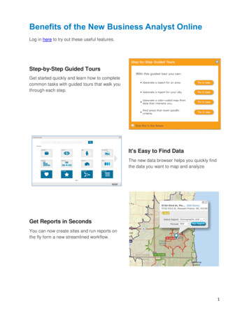
Task checklistTASKCOMPLETE1.Get the guidance you need2.Enable ArcGIS Image Analyst3.Visualize data in image space4.Classify imagery and use deep learning5.Perform change detection6.Analyze multidimensional raster data7.Improve imagery with Pixel Editor tools8.Work with stereo images9.Get started with full motion video10. Process imagery with advanced functions11. Additional resourcesCopyright 2019 Esri. All rights reserved.2
1. Get the guidance you needThe purpose of the Getting to Know ArcGIS Image Analyst guide is to give youhands-on experience with the ArcGIS Image Analyst in ArcGIS Pro. You’ll get startedwith stereo imagery, deep learning image classification, full motion video, and otheradvanced functionality.We want you to be successful when you work through this guide, but there may beanother guide or resource that is better suited to your goals. Look at the list of rolesbelow to find out which resources are best for you.If you’re an imagery analyst or GIS professional If you are an imagery analyst or a GIS professional looking to get more familiar withadvanced image processing capabilities, this is the guide for you!If you’re new to GIS or imagery If you are a new ArcGIS Pro user or simply new to image analysis, work through thetutorials below before diving into the Getting to Know ArcGIS Image Analyst guide. Get started with ArcGIS Pro using this guided learn path. Learn how to use ArcGIS Pro to predict deforestation in Brazil. Get started with imagery by exploring the Esri Landsat app.If you’re an administrator or manager If you are an administrator or a manager and you are looking for help accessing,downloading, and licensing ArcGIS Pro and extensions like the ArcGIS Image Analyst,download the ArcGIS Pro Implementation Guide.There you will learn how to obtain, install, and set up ArcGIS Pro for you and yourorganization.Copyright 2019 Esri. All rights reserved.3
2. Enable ArcGIS Image AnalystArcGIS Image Analyst is an extension for ArcGIS Pro that gives you access to enrichedvisualization, geospatial analytics, and powerful image exploitation tools. It isdesigned for analysts, scientists, and photogrammetrists who process, interpret,analyze, and create information products from imagery and other remotely senseddata.Learn how to purchase the ArcGIS Image Analyst extension.Once you have purchased ArcGIS Image Analyst or requested a free trial, you canenable it in ArcGIS Pro. You’ll need an administrator of your organization to assignyou the ArcGIS Image Analyst license. Once assigned, you’ll have immediate accessto the tools and capabilities that come with ArcGIS Image Analyst.Learn how to view and authorize ArcGIS Pro extension licenses.Before you jump into the ArcGIS Image Analyst, watch a few short videos to help youunderstand just a few of the fundamental capabilities of image analysis in ArcGIS Pro: Feature extraction: See the different classification tools that enable you toextract quantifiable features from imagery. [5 minutes] Process raster data: Watch how quickly images and raster data can beprocessed using raster functions. [5 minutes] Stereo viewing: See how to view imagery in stereo and extract 3D features. [2minutes] Enriched visualization and measurement: Watch how to view imagery andmake measurements in image space. [4 minutes] Full Motion Video: See the new Full Motion Video functionality in action. [3minutes]Start the ArcGIS Image Analyst video playlist.Copyright 2019 Esri. All rights reserved.4
3. Visualize data in image spaceOblique imagery can look distorted in projected map space, making it hard tointerpret. With ArcGIS Image Analyst, you can display imagery from the perspectiveof the sensor. In image space, buildings and features can be oriented vertically withno distortion related to terrain, so they’re easier to interpret. Features can beinteractively measured, or they can be digitized, edited, and saved in a mapprojection.Watch the following video to get an introduction to working in image space, then gethands-on experience with the tutorial.See a demonstration of image space in action.Get hands on experience working in image space.Copyright 2019 Esri. All rights reserved.5
4. Classify imagery and perform deeplearningExtracting GIS data from an image can be done by digitizing features on top of ageoreferenced image, detecting objects using deep learning techniques, ordelineating features using image classification. Image classification refers to the taskof assigning classes—defined in a classification system or schema—to all the pixels in aremotely sensed image. The output raster from image classification can be used tocreate thematic maps, quantify resources, or detect change.In the following guided learning path, you will learn: The basics of image segmentation, classification and machine learning:watch a presentation from Esri experts on image classification techniques [1hour] How to extract land cover types from imagery: get hands-on experience byextracting impervious surfaces from a remotely sensed image. [1.5 hour] The Image Classification Wizard: walk through the guided wizard in ArcGISPro to create a thematic map from imagery. [30 minutes] How to use spectral profiles to improve results: find out how you can usecharts in ArcGIS Pro to improve your classification. [1 hour] How to integrate deep learning with ArcGIS Pro: use a trained deeplearning model to extract palm tree location and health from an image. [1.5hours]Learn how to extract features from imagery in ArcGIS.Copyright 2019 Esri. All rights reserved.6
5. Perform change detectionChange detection is one of the fundamental processes in remote sensing. With thetools and capabilities available with the Image Analyst extension, you can performchange detection between categorical or continuous raster datasets, or even over atime series of images.using categorical data, then you’ll perform pixel value differences in vegetation usingLandsat imagery. Then watch a video on time series change detection.Evaluate Ethiopia’s changing landscape using the Change Detection Wizard.Next, check out this video on time series change detection.Copyright 2019 Esri. All rights reserved.7
6. Analyze multidimensional raster dataMultidimensional data represents data captured at multiple times or multiple depthsor heights. These data types are commonly used in atmospheric, oceanographic andearth sciences. With the ArcGIS Image Analyst, you can manage, visualize, andprocess multidimensional raster data, and publish them as a web service. Adding amultidimensional raster layer to your map allows you to quickly display and exploreyour variables.Use the following tutorials and articles to find out how you can use multidimensionalraster data for trend analysis, anomaly detection, and prediction. Work with multidimensional dataVisualize temporal trends and anomalies in sea surface temperature data. Get started with multidimensional raster dataGenerate a multidimensional mosaic dataset from a group of Landsatimages, then convert the mosaic dataset into the Esri native Cloud RasterFormat and visualize changes in the Chuquicamata mine in Chile. How to create multidimensional raster dataWatch three short videos on the three ways to create a multidimensionalraster dataset. Analyze climate impact on wine production using multidimensional analysisRead about how to use multidimensional raster analysis to predict theclimate change impact on crops Find out how plant hardiness zones will change with multidimensional dataSee how to use the arcpy API to explore multidimensional data forenvironmental analysis.Copyright 2019 Esri. All rights reserved.8
7. Improve imagery with Pixel Editor toolsWith Pixel Editor functionality in the ArcGIS Image Analyst, you can interactivelymanipulate pixel values for raster and imagery data. This allows you to edit individualpixels or a group of pixels at one time. Editing operations are enabled according toyour raster type and include options for pixel or object removal, redaction, filtering,and reclassification.In the following guided learning path, you’ll learn the basics of the Pixel Editor andsee some of the tools and capabilities available.Learn about editing rasters in ArcGIS Pro with Pixel Editor.Copyright 2019 Esri. All rights reserved.9
8. Work with stereo imagesStereoscopy is the science of using overlapping images acquired from a remotesensor at different look-angles to produce 3D models that emulate true binocularvision. With the ArcGIS Image Analyst, you can visualize stereo pairs and create 3Dfeatures in a stereo mapping environment.To get an understanding of stereo mapping in ArcGIS Pro, read through the followingdocumentation, which describes: How to prepare satellite data for stereo mapping: Build a mosaic datasetfrom overlapping imagery. How to prepare aerial data for stereo mapping: Build a mosaic datasetfrom overlapping imagery. How to enable stereo viewing: See what is required and how to enablestereo viewing in an ArcGIS Pro project. Create a stereo map: Visualize multiple stereo models in a stereo map anduse tools to navigate the map.Then learn how to collect 3D features in stereo with this Learn Lesson.Copyright 2019 Esri. All rights reserved.10
9. Get started with full motion videoWith full motion video (FMV) in the ArcGIS Image Analyst, you can work with aerialvideo data right in your map. You can visualize a drone-captured video in the videoplayer while seeing the path of the video frame update in your map. You can evencapture geospatial features using the video player or pause the video and export thecontents to a PowerPoint presentation with one click. For even more information, youcan use deep learning models to track and extract object information from videos, allwithin ArcGIS Pro.Use the following exercises and videos to learn about full motion video: Work with the video playerTake a tour of the tools and functionality of the video player. Create features in your videoDigitize points of interest on your video and save them for analysis. Use the video multiplexer toolSee how to use the multiplexer tool to combine archived video withmetadata to create FMV-compliant data. Use deep learning with full motion videoSee how drone footage is used with predictive modeling tools in ArcGIS toconduct an automated, repeatable catfish survey.Copyright 2019 Esri. All rights reserved.11
10. Process imagery with advancedfunctionsRaster functions are operations that apply processing directly to the pixels of imageryand raster datasets on-the-fly. You can choose to keep the output imagery bypersisting the data, but by default, no new raster is created to take up space on thedisk, and only pixels that are visible on your screen are processed so the computationtime is fast.ArcGIS Image Analyst provides a suite of raster functions in addition to the functionsavailable in ArcGIS Pro. For example, the Focal Statistics function and the WeightedSum function are available with the ArcGIS Image Analyst.Learn how to process imagery with raster functions.Copyright 2019 Esri. All rights reserved.12
11. Additional resources ArcGIS Image Analyst documentation is the best resource for learning howto use the software in general and to perform specific tasks. It also includesthe list of geoprocessing tools and raster functions available with theextension. The Learn ArcGIS gallery includes a collection of lessons, articles, StoryMaps, and videos that help you learn about ArcGIS. It includes a lot of greatcontent on imagery and remote sensing. The GIS community, including Esri, shares thousands of ready-to-useauthoritative datasets in ArcGIS Living Atlas of the World. Living Atlascovers everything from historical census data to environmental conditionsderived from live sensor networks and earth observations.Copyright 2019 Esri. All rights reserved.13
If you are a new ArcGIS Pro user or simply new to image analysis, work through the tutorials below before diving into the Getting to Know ArcGIS Image Analyst guide. Get started with ArcGIS Pro using this guided learn path. Learn how to use ArcGIS Pro to predict deforestation in Brazil.