Transcription
Architecting the ArcGIS System: Best PracticesAUGUST 2021Architecting theArcGIS System:Best Practices
Copyright 2021 EsriAll rights reserved.Printed in the United States of America.The information contained in this document is the exclusive property of Esri. This work is protected under United States copyright law andother international copyright treaties and conventions. No part of this work may be reproduced or transmitted in any form or by any means,electronic or mechanical, including photocopying and recording, or by any information storage or retrieval system, except as expresslypermitted in writing by Esri. All requests should be sent to Attention: Contracts and Legal Services Manager, Esri, 380 New York Street,Redlands, CA 92373-8100 USA.The information contained in this document is subject to change without notice.Esri, the Esri globe logo, The Science of Where, ArcGIS, esri.com, and @esri.com are trademarks, service marks, or registered marks of Esriin the United States, the European Community, or certain other jurisdictions. Other companies and products or services mentioned herein maybe trademarks, service marks, or registered marks of their respective mark owners.
Architecting the ArcGIS System: Best PracticesWhat’s New (August 2021)This update includes minor corrections and clarifications, with some substantive updates to the “Collaboration” and“Governance” articles.ModificationsThe “Distributed Web GIS” article was updated and renamed to “Collaboration: Enable People to Work Together.”This update reflects changes in ArcGIS to more broadly support collaboration among teams and stakeholders.The “Governance: The Policy and Practice of Enablement” article was updated for clarity.We also reviewed and made minor updates to the remaining best practices to align with the latest Esri messaging.The content of most of the best practices, including their recommendations, remains unchanged.3
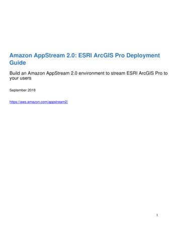
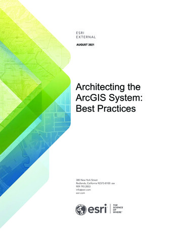
Architecting the ArcGIS System: Best PracticesIntroductionYou can maximize the value of ArcGIS in the context of your organization’s goals, by applying the guidelines presented inthese best practices and implementation approaches.Architecting ArcGISArcGIS is a system that connects maps, apps, data, and people in ways that help organizations make more informedand faster decisions. ArcGIS accomplishes this by making it easy for everyone in an organization to discover, use,make, and share maps from any device, anywhere, anytime. Furthermore, ArcGIS is designed to be flexible, offeringthese capabilities through multiple implementation patterns and approaches. Together, these capabilities and flexibleapproaches make it easier for you to extend the reach of GIS across the enterprise.This document presents some implementation guidelines in the form of a conceptual reference architecture diagramand associated best practice briefs. You can use these guidelines to maximize the value of your ArcGISimplementation and meet your organizational objectives.Conceptual Reference ArchitectureThe ArcGIS Conceptual Reference Architecture diagram (found onpage 6) illustrates the capabilities of ArcGIS combined with bestpractices.The diagram depicts three distinct compute environments—production, staging, and development—which together represent abest practice known as environment isolation. Each environment hasfour components, with each section displayed in a different color tohighlight the function. Figure 1 identifies those components by colorand number.The Apps section illustrates the components of ArcGIS that mostusers interact with, including clients such as ArcGIS Pro, mobilenative apps, and web applications. Apps connect people and theirbusiness workflows to ArcGIS. Apps are typically used in workflowsthat follow one or more of the patterns of use (mapping &visualization, data management, field mobility, monitoring,analytics, design & planning, decision support, constituentengagement, and sharing & collaboration). For example, the sharing& collaboration pattern extends geospatial capabilities to everyonein the organization by providing a destination (website and simpleapps) where knowledge workers, executives, and field workers canaccess information and capabilities. A person capturing data in thefield is following the field mobility pattern. A decision-makerobserving the real-time information created by field workers isfollowing the decision support pattern.Figure 1: Components of the ArcGIS ConceptualReference Architecture: 1, Apps (orange); 2, Portal(green); 3, Infrastructure (blue); and 4, ExternalSystems and Services (purple).The Portal component of ArcGIS organizes users and connects them with the appropriate content and capabilitiesbased on their role and privileges. The portal uses a person’s identity to deliver the right content to the right personat the right time. From a product perspective, the portal is either ArcGIS Enterprise (software) or ArcGIS Online(Software as a Service, or SaaS). The portal provides access controls, content management capabilities, and a sharingmodel that enables users to share information within and/or between organizations.The Infrastructure component includes the hardware, software, services, and data repositories that are the core ofthe ArcGIS system. Many best practices—including load balancing, high availability, workload separation, and4
Architecting the ArcGIS System: Best Practicespublication strategies—offer key considerations that may affect your infrastructure decisions. Follow the links fromeach best practice label on the Conceptual Reference Architecture diagram to learn more about how these strategiesaffect infrastructure decisions. Additional information is also available in the Infrastructure best practice brief.The External Systems and Services components include other systems that either provide services to ArcGIS orconsume ArcGIS services to geospatially enable their capabilities. The ability to easily geoenable other enterprisebusiness systems is a key capability of ArcGIS.Best PracticesThere are 20 best practice briefs associated with the ArcGIS Conceptual Reference Architecture diagram.Eleven of these briefs—Automation, Collaboration, Enterprise Integration, Environment Isolation, High Availability,Infrastructure, Load Balancing, Publication Strategy, Real-time GIS Strategy, Security, and Workload Separation—reference technology practices that provide high-level implementation guidelines based on business needs. Followingthese best practices will help organizations meet requirements for performance, security, and availability.The best practice briefs for Application Implementation Strategy, Capability Delivery, Communicating Success,Geospatial Strategy, Managing Identities, Patterns of Use, Prioritization Approach, and Workforce Development focuson people and how they should interact with ArcGIS.Finally, the Governance brief offers a complementary process guideline that suggests ways to minimize risk, improvequality, and increase productivity around ArcGIS solutions.How to Use This DocumentThe ArcGIS Conceptual Reference Architecture diagram is a clickable graphic that contains links to each best practicebrief. You can use the diagram to explore how the individual briefs relate to ArcGIS, or to visualize how ArcGIS willsupport organizational business needs.Comments and SuggestionsAny comments or suggestions regarding this document can be emailed to SA@esri.com.5
DataManagementMapping &VisualizationSDKs / APIsAPPSArcGIS ConceptualReference ArchitectureField MobilityMonitoringAnalyticsSolutionsDesign ng &CollaborationPatterns of UseP O R TA LSDKs / APIsUsers Groups Items TagsWeb LayersToolsFilesINFRASTRUCTURESDKs / APIsLOA D B A L A N C I N GDataManagementAnalysisVisualizationH I G H AVA I L A B I L I T YW O R K LOA D S E PA R AT I O NEnterpriseSystemsSDKs / APIsWeb MapsEXTERNAL SYSTEMS AND SERVICES(Content and Capabilities) CRM EAM BI Microsoft OfficeOther Social Weather Traffic Real-time Feeds IoT SensorsData and StoragePRODUC TIONS TAG I N GD E V E LO P M E N TA SSO C I AT E D B E S T PR AC T I C E SAutomation Capability Delivery Communicating SuccessGeospatial Strategy Governance Prioritization ApproachPublication Strategy Security Workforce DevelopmentCopyright 2021 Esri. All rights reserved.August 2021
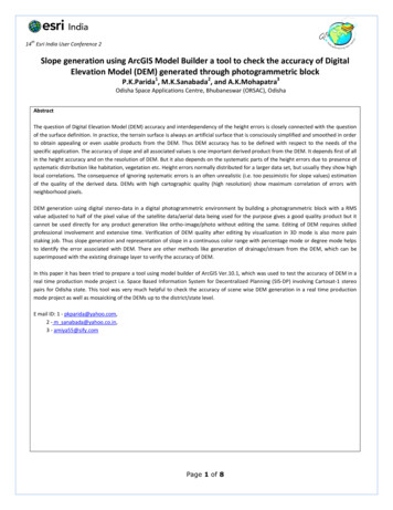
Architecting the ArcGIS System: Best PracticesApplication Implementation StrategyAn application implementation strategy is an approach to delivering capabilities that meet your business needs withtechnology. An ideal strategy will minimize cost and optimize the use of development resources. By applying a “configurefirst” philosophy that prioritizes commercial off-the-shelf (COTS) apps and least-effort design patterns, you can reducethe cost and effort needed to deploy and maintain applications for your users.A Flexible System for Implementing Location-Enabled AppsArcGIS lets you apply the power of geography to improve workflows throughout your organization. Apps provide theuser experience that makes ArcGIS capabilities available at the right time on the right device, so users can work moreefficiently. Implementing apps, however, can require different approaches, depending on whether the capabilitiesyou need are available out of the box. ArcGIS helps you deliver these capabilities by supporting multiple approachesto application implementation (as shown in figure 2), while also helping you minimize cost and effort.There are many factors to consider when deciding the best way to deliver newcapabilities through apps. These factors include resourcing, initial developmenteffort, ongoing app maintenance, user training, and technical support. In addition,users now expect frequent updates to their apps, which increases demand forresources to develop and maintain custom apps. As a result, it’s best to select theapproach that delivers the capabilities you need with the least cost and effort.Depending on your specific requirements, you can:1. Configure COTS apps to meet your business needs. ArcGIS provides manyconfigurable COTS apps that support key workflows out of the box. UsingCOTS apps requires the least effort and the lowest ongoing cost.Figure 2: Configure first for thelowest cost and least effort, thenextend and customize as needed.2. Extend existing apps, either by modifying templates or by creating widgets for COTS apps. Esri offers apptemplates at arcgis.com and github.com/esri that provide focused solutions for specific problems; you canmodify the source code for these templates to add discrete capabilities. In addition, several ArcGIS COTS appsuse modular frameworks that let you create custom widgets and plug them into the apps. Extending existingapps lets you develop only the additional functionality you need, saving money and effort.3. Customize apps using ArcGIS APIs and SDKs. These APIs and SDKs provide objects like the Identity Managerto manage credentials within custom apps that expose ArcGIS capabilities (such as secure web maps).Because you don’t have to code those parts yourself, you can build business-focused apps to take advantageof ArcGIS COTS capabilities, reducing the overhead for app development and maintenance.A configure-first philosophy helps you avoid unnecessary cost and effort associated with custom app development,maintenance, and training. Organizations that adopt a configure-first philosophy start by configuring COTS apps, thenextend and customize apps only when needed. Using this least-effort approach in your application implementationstrategy lets you deliver capabilities faster and reserve your development resources for more complex tasks.RecommendationsTo establish an effective application implementation strategy for your organization:1. Adopt a configure-first philosophy, configuring COTS apps when possible to deliver the capabilities you need.2. If you have a requirement that cannot be met with configuration alone, extend existing apps with discretecapabilities and widgets.3. When you need capabilities that you can’t provide by configuring and extending existing apps, customizeapps using ArcGIS APIs and SDKs.Back to Reference Architecture7
Architecting the ArcGIS System: Best PracticesAutomationAutomation is the orchestration of tasks, processes, and compute resources to function automatically and efficiently.Automation allows you to streamline administrative workflows and repetitive tasks to improve efficiency, consistency,and productivity, reducing risk and increasing the value of your GIS.Increasing the Value of ArcGIS Through AutomationRepetitive tasks are common when using GIS to support datamanagement, analysis, map production, and infrastructuredeployment and operations. Repetitive manual tasks take a lot oftime, effort, and focus; decrease overall productivity; andincrease risk. These impacts are compounded as the number oftasks grows.You can mitigate these impacts through automation. Automationallows technology to create and maintain infrastructure andprogrammatically execute the steps of a well-defined workflowwhile limiting human interaction. Common tools for automationinclude APIs and scripts.Automation maximizes your investment in ArcGIS by improving:1. Efficiency. Information is most useful to the decisionmaking process when it is delivered in a timely manner.Because automating tasks and resource allocationimproves efficiency, work can be completed faster andnew information can be delivered to stakeholderssooner. This boost in efficiency allows ArcGIS to returngreater value to the business.Automation Tames the Internet of Things (IoT)As the volume and velocity of IoT data increases,automation becomes both more necessary andmore valuable to the business.Working manually, staff often struggle withprocessing the high volumes of data producedby IoT devices and scaling infrastructureaccordingly. This delays the transformation ofdata into insight, which in turn reduces theorganization’s efficiency and makes its decisionsless responsive and less effective.With automation, you can process IoT dataefficiently, consistently, and routinely. Forexample, you can automatically allocatecompute resources to your infrastructure toscale up and down as data volume andprocessing needs fluctuate. This keeps IoT dataflowing to key workflows and business systems,improving efficiency and supporting better,faster decisions.2. Consistency. When tasks are executed manually, errorsare more common and outcomes can be inconsistent, unreliable, and costly. Once developed and properlytested, automated processes are highly dependable and can be replicated with identical and predictableresults. Automated processes save time, minimize duplicated efforts, and increase confidence in businessoperations.3. Productivity. Automation can improve all areas of a GIS including deployment, administration, and end-userworkflows. By using automation to execute more GIS tasks and complete them faster, you can increaseoverall productivity. This lets you apply ArcGIS to additional business initiatives (such as strategic projects,research and development efforts, and other high-value projects) that might otherwise go unfulfilled.With automation, you can improve administrative workflows and process data more efficiently, consistently, androutinely. This improves operational efficiency and the effectiveness and timeliness of decision-making, freeingresources for other tasks and boosting the value of ArcGIS in your organization.RecommendationsTo maximize the benefits of automation and reduce risk in your organization:1. Automate tasks where human error can impact reliability and consistency in outcomes.2. Automate lengthy tasks so processes can be completed in less time.3. Schedule automated tasks so they run continuously within set time windows, without human interaction.Back to Reference Architecture8
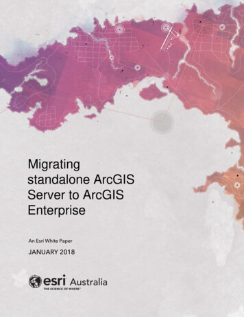
Architecting the ArcGIS System: Best PracticesCapability DeliveryDelivering capabilities that support key requirements, goals, and initiatives helps you improve business outcomes. Byworking with stakeholders to define the capabilities you deliver, you can better align your solutions with real businessneeds. In addition, establishing a regular cadence for capability delivery lets you continuously improve your maps, apps,services, and information products, so they can provide additional value and meet evolving requirements.A Business-First Approach to Delivering New CapabilitiesDelivering capabilities that support your business requires smart resource investments. Organizations that spendyears on expensive, complex development projects often end up with solutions that are difficult to use or that don’talign with current requirements. To maximize the value of your investments and better support the evolving demandsof your business, you can work with stakeholders to identify areas where you can provide the most value in the leasttime. This business-first approach helps you establish a cadence for rapidly delivering high-impact capabilities andinformation products that meet business needs.For effective capability delivery, you should:1. Collaborate with business stakeholders toenvision their capability needs. Engagingstakeholders early in the planning processhelps you identify the business value acapability will provide, balance value againstrisk, and set development priorities. Youcan then apply a configure-first approach,deploying low-effort capabilities first. Thisdelivers value quickly and builds towardlong-term success. Once you have a finalproduct, you can invite stakeholders to test Figure 3: Capability delivery follows a cadence and terminates when thesolution no longer provides value to the business.it and offer feedback.2. Iterate rapidly on existing solutions so you can deliver new value quickly and often. By focusing onincremental enhancements that provide clear value, you can avoid spending development time onfunctionality that adds unnecessary complexity. A rapid release cycle should be 30 days or less, with eachiteration producing a usable deliverable. To meet this short release schedule, you can keep requirementssimple and focused, and leverage COTS and configurable solutions when possible. With each new release,you can solicit stakeholder feedback to drive the next iteration.3. Adhere to a capability delivery lifecycle with a regular cadence, like the lifecycle shown in figure 3. This helpsyou continue iterating on your solutions as long as the business gains new value from each iteration. Onceyou satisfy your stakeholders’ needs, you can suspend further iterations, then resume them if future businessneeds require additional enhancements. When a solution no longer provides value, its lifecycle is complete.Deprecating these legacy solutions lets you avoid consuming resources unnecessarily.RecommendationsTo deliver capabilities that maximize business value and make effective use of development resources:1. Collaborate with business stakeholders to define, prioritize, and test new capabilities.2. Keep iteration cycles short and focus on supplying incremental business value with each new release.3. Establish a regular cadence for new iterations until you satisfy all identified business needs, and deprecatesolutions that no longer provide value.Back to Reference Architecture9
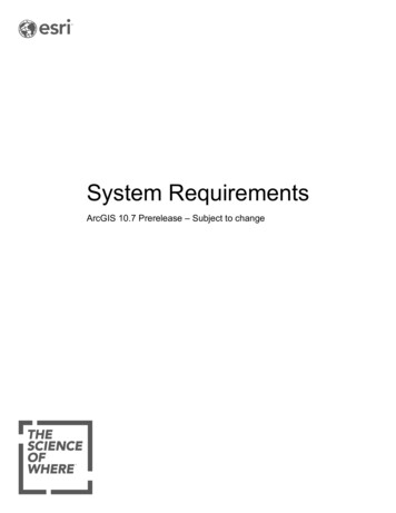
Architecting the ArcGIS System: Best PracticesCollaboration: Enable People to Work TogetherCollaborations enable people from multiple ArcGIS organizations to work together and share content through trustedand secure workflows. By implementing one or more collaborations, you can more effectively leverage authoritativedata, foster engagement and communication, and glean insights from data. Collaborations let you preservedepartmental control over data and workflows while supporting the needs of the entire organization.A Modern Approach to Sharing InformationArcGIS supports two types of collaboration for an improved type of sharing. Adistributed collaboration is a configuration between ArcGIS Enterprise and/orArcGIS Online, while a partnered collaboration works between ArcGIS Onlineorganizations. With this integrated approach, each department controls accessto their shared items, while enabling authorized people to contribute edits oraccess authoritative information, promoting more interactive and integrateddata maintenance workflows and information sharing. The result is a trulycollaborative environment—an integrated set of deployments working towardshared goals.For example, an organization might have multiple business units, each with itsown GIS deployment supporting different business functions. In a city, thepolice department, fire department, public works department, and municipalwater utility might each deploy their own GIS to support their individualworkflows. By configuring collaborations, you can connect those organizationsso people across departments or outside the organization can work togetherto create, maintain, and use authoritative data. Figure 4 illustrates theserelationships using both a distributed collaboration and a partneredcollaboration. Together, these collaborations enable people to work bettertogether.Figure 4: Preserve control and accesswithin individual departments whilesupporting the broader needs of theenterprise and cross-departmentalworkflows.Collaborations expand a modern GIS by making its capabilities and data easierto access across the enterprise without sacrificing security. You can now configure an organizational network wherecontent can be shared in a simple and controlled manner. This enables business units to share, update, or sync selectinformation with the broader enterprise while maintaining control of sensitive data.Each organization within a collaboration maintains its own maps, apps, services, and data. Each participatingorganization chooses which content to share with members of the collaboration; updates can be shared either in realtime or at scheduled intervals. Importantly, a collaboration uses each organization’s existing security model.With collaboration enabled, you can achieve larger organizational goals through distributed and partneredcollaborations, well-defined sharing processes, and automation, all within ArcGIS.RecommendationsTo fully leverage collaboration within your own organization:1. Model your ArcGIS system after your organization’s structure.2. If you have departments or business units that need to control sensitive data, allow each to work in its ownGIS deployment as part of a trusted collaboration.3. Establish collaborations between organizations based on business need and workflows, enabling the rightpeople to update and/or have access to the authoritative content they need.Back to Reference Architecture10
Architecting the ArcGIS System: Best PracticesCommunicating SuccessCommunicating successful outcomes motivates and incentivizes people in your organization to support GIS. Byreinforcing the business value of GIS, you can build stakeholder support and encourage people to build new GIScapabilities that solve business problems and help the organization achieve its goals.Communication: One Action, Three OutcomesCommunication is key to building and sustaining GIS investments. Organizations recognize the need for effectivecommunication when they are defining their geospatial strategy, but often they don’t realize that communication isequally important when they are executing that strategy.After you deliver a geospatial solution that solves a business problem, you should communicate your success withstakeholders throughout the organization. Doing so produces three positive outcomes:1. Awareness: Good communication informs stakeholders that real business value was created from theirinvestment in GIS. Without communication, stakeholders may not know that GIS is providing value to theirbusiness processes. They may not understand how GIS is contributing through spatial analysis, mobileworkflows, decision support, or information sharing. They may see expenditures without realizing thebenefits. By publicizing your success to stakeholders, you can help them better understand the power ofgeospatial technology and make them aware of the value it’s providing. This is crucial for GIS to be seen as agood investment that helps the organization meet its goals.2. Incentive: Good communication encourages other people in the organization to think about how GIS canhelp them. When people can see what is possible with GIS, they are more likely to want to participate in newGIS projects. This builds demand and expands the pool of resources that can use GIS. As a result, you canleverage your GIS technology investments more fully to deliver the most value possible to the organization.3. Acknowledgment: Good communication celebrates and motivates the people that deliver geospatialsolutions for the organization. Timely and authentic employee recognition builds trust and helps you foster apositive culture. In turn, this helps you encourage the people responsible for building solutions, so you cancontinue to deepen the value of geospatial technology to the organization.Together, these outcomes will help you sustain your GIS program, advocate for additional resources, and increaseyour impact.RecommendationsAfter you deliver a new solution, you should:1. Communicate your success in order to promote greater awareness of GIS, incentivize potential users, andacknowledge the hard work of your teams.2. Communicate the business impact of your success by highlighting new workflows that save time, reducecosts, or improve effectiveness; by showing how business units are using GIS to work together or improvetheir operations in tangible ways; and by illustrating more informed decision-making thanks to geospatialtechnology.Back to Reference Architecture11
Architecting the ArcGIS System: Best PracticesEnterprise Integration: Application PatternsApplication integration patterns describe different approaches to incorporating location intelligence into applications.You can use these patterns to identify how users will interact with geospatial content, and how capabilities from GIS andother business systems should integrate.Patterns for Integrating GIS with Business ApplicationsApplication integration lets you deliver solutions thatcombine data and tools from disparate systems—includingyour GIS as well as business systems like permitting,licensing, and asset management systems. With integratedsolutions, you can improve cross-functional businessprocesses and provide decision-makers with integrated viewsof your organization’s information.How you integrate GIS with other systems will depend onwhich system you use as the hosting framework. ArcGIShelps you meet varying integration needs by supportingmultiple application integration patterns (as shown in figure5). These patterns include:Figure 5: Application integration patterns for ArcGIS.1. Geocentric applications, which enhance GISapplications with business data and capabilities to automate or inform location-centric activities. Geocentricapplications are dominated by geospatial content and capabilities, while delivering business content andcapabilities secondarily. This pattern typically uses a GIS application as the hosting framework. It is bestsuited for staff who are familiar with GIS applications, for situations where GIS activities are central, or forcases where a user-friendly GIS template or configurable app provides most of the needed functionality.2. Geoenabled applications, which enhance business applications with GIS data and capabilities to automate orinform business activities. Geoenabled applications are dominated by business system content andcapabilities that are supplemented by GIS capabilities. This pattern typically uses the business system as thehosting framework. It is best suited for staff who are familiar with the business system that automates therelated workflows, or when an extensible business system provides most of the needed functionality.3. Composite applications, which integrate capabilities from multiple systems in situations where no existingsystem can or should serve as the hosting framework. This pattern typically uses web services to integratedata and logic from multiple systems to derive new functionality. Composite applications are conceptuallycomparable to mashups, and they represent a contemporary trend in enterprise application development.No single application integration pattern fits all situations. You can use the application pattern that best combinescapabilities from ArcGIS and your business system to deliver the greatest impact.RecommendationsThe following guidelines can help you determine which application integration pattern best suits your situation:1. If most of the capabilities you need are delivered by your GIS, deploy a geocentric application.2. When you need to access GIS content and capabilities within a business system or application, deploy ageoenabled application.3. When you need a discrete application that integrates content and capabilities from both your GIS andexisting business systems, build a composite application.Back to Reference Architecture12
Architecting the ArcGIS System: Best PracticesEnvironment IsolationIsolating computing environments is an approach to maintaining system reliability and availability. This approachinvolves creating separate systems for production, testing, and development activities. Environment isolation reducesrisk and protects operational systems from unintentional changes that negatively impact the business.Deploying Isolated Environments to Safeguard Operational SystemsUnintentional system changes can cause operational systems to fail to deliver the capabilities and performance thatusers expect. Environment isolation insulates different computing environments from the risk of unmanaged change,helping you better maintain t
Architecting ArcGIS . ArcGIS is a system that connects maps, apps, data, and people in ways that help organizations make more informed and faster decisions. ArcGIS accomplishes this by making