Transcription
Maps of the First Survey of the Potomac River, 1736-1737Author(s): James W. FosterSource: The William and Mary Quarterly, Second Series, Vol. 18, No. 2 (Apr., 1938), pp. 150157Published by: Omohundro Institute of Early American History and CultureStable URL: http://www.jstor.org/stable/1923495Accessed: 25/08/2009 09:45Your use of the JSTOR archive indicates your acceptance of JSTOR's Terms and Conditions of Use, available rms.jsp. JSTOR's Terms and Conditions of Use provides, in part, that unlessyou have obtained prior permission, you may not download an entire issue of a journal or multiple copies of articles, and youmay use content in the JSTOR archive only for your personal, non-commercial use.Please contact the publisher regarding any further use of this work. Publisher contact information may be obtained herCode omohundro.Each copy of any part of a JSTOR transmission must contain the same copyright notice that appears on the screen or printedpage of such transmission.JSTOR is a not-for-profit organization founded in 1995 to build trusted digital archives for scholarship. We work with thescholarly community to preserve their work and the materials they rely upon, and to build a common research platform thatpromotes the discovery and use of these resources. For more information about JSTOR, please contact support@jstor.org.Omohundro Institute of Early American History and Culture is collaborating with JSTOR to digitize, preserveand extend access to The William and Mary Quarterly.http://www.jstor.org
WilliamandMaryCollegeQuarterly Historical MagazinePublished by William and Mary CollegeWILLIAMSBURG,VIRGINIAE D I TO R SJOHNSTEWARTE. G. SWEM,Librarian William andMary CollegeBRYAN,President William and MaryCollegeVol. 18APRIL, 1938API,13SECONDSERIESNo. 2MAPS OF THE FIRST SURVEY OF THEPOTOMAC RIVER, 1736-1737ByJAMESW.FOSTERWhen the Enoch Pratt Free Library of Baltimore a fewmonths ago took over as a permanent deposit from the MarylandAcademy of Sciences a collection of maps, both printed andmanuscript, there came to light two complementary plats of thePotomac River drawn in 1736-1737 by order of the commissionersappointed to survey the boundaries of Lord Fairfax's immenseestate, the Northern Neck of Virginia. Since they must have beenamong the original documents on which William Mayo actingfor the Crown commission and John Warner on behalf of theFairfax representatives based their maps of the Northern Neck'and because they furnish various details not shown on either ofthese, they possess no little historical importance. Nor is theirinterest as examples of early local cartography unmatched in otherrespects, for few streams of America have afforded grounds formore continued controversy than the Potomac. As a matter of1 A map of the Northern Neck in Virginia, The Territory of theRight Honourable Thomas Lord Fairfax; Situate betwixt the Rivers Potomack and Rappahannock, according to a late Survey; Dr-awn in theyear 1737, by Wm. Mayo.A trite and accurate survey of the Rivers Rappahannock and Patomnackto their first heads or Springs done by order of the Commissioners as wellon the part of His Majesty as the Lord Fairfax . . . Drawn by JohnWarner [17371.
150WILLIAM AND MARY QUARTERLYfact, one of the maps has been found pertinent to current litigation in a Federal Court.The plats bear the following legends:PLAN OF THE UPPER PART OF POTOMACKSURVEY'D INRIVER CALLED COHONGOROOTO.THE YEAR 1736 [Signed:] BENJ. WINSLOW.Pen drawing with ink wash representing mountains and otherphysical features. 42'2 x 16 inches. Scale 2.2 miles to theinch.A PLAN OF POTOMACK RIVER, FROM THEMOUTH OF SHERRENDO, DOWN TO CHAPAWAMIN THE YEAR 1737.[Signed:]SICK, SURVEYEDRO [BERT] BROOKE.Pen drawing. 17'2 x 24'2 inches. Scale 2Y'2 miles to theinch.While it is here proposed to discuss only the first of thesedrafts, it may not be amiss to review briefly the purposes forwhich they were prepared. The circumstances are nowhere sofully or pithily set forth as in the account of Colonel WilliamByrd who, as one of the commissioners appointed by GovernorGooch on a royal order to meet with commissioners named byLord Fairfax, has left a narrative of marked style and force ifmnotof judicial impartiality.2 Though it was Fairfax who had,precipitated action by petitioning the king for a joint commission to survey and fix the boundaries of his enormous demesne,upon the naming of the Crown negotiators, he changed his mind,doubtless feeling that his interests would be safer if left to aroyal commission in England where the rights of a peer might beexpected to enjoy higher esteem than in the American wilderness,and empowered his commissioners merely to survey the boundariesand take testimony regarding the accepted limits. His appointeeswere Charles Carter, William Beverley and William Fairfax.Governor Gooch on behalf of the Crown commissioned, besidesByrd, John Robinson and John Grymes.It will be recalled that the origin of the boundary disputes layin grants made both by the Governor of Virginia and by LordFairfax in the fork of the Rappahannock River, but their ultimatecause was the equivocal expression used in the royal letters patentrunning in the name of Fairfax's ancestor, Thomas, Lord Culpeper, viz., "all that intire tract . . . bounded by and within the2 The Proceedingsof the Commissioners Appointed to Lay out theBounds of the Northern Neck, lying between the Rivers Potomack andRappahannock. Anno 1736 in William Byrd, History of the Dividing Lineand Other Tracts, Richmond, 1866, Vol. II, pp. 83-139.
WILLIAMAND MARYQUARTERLY151first Heads or Springs of the Rivers . . . Rappahannock, &Potomack & by the Courses of the said Rivers from their saidfirst Heads or Springs (as they are commonly called or knownby the Inhabitants & Discriptions of those parts) and the Bay ofChesapeyock . ." Thus charged with responsibility to locate thehead springs of these rivers, the commissioners entered with seeming assurance upon a task that in the case of the Potomac remains,strictly speaking, uncompleted to the present day.3The joint commission met on September 25, 1736, at Fredericksburg where, according to the voucher for their expenses,they were not indifferent, while considering the controversialaspects of their task, to the joys of the table. During the fivedays of the conference they consumed substantial quantities ofclaret, madeira, beer, tea, punch and liquor, while "sundry liquorsfor woodsmen and surveyors" ran to more than ?11. With lodgings for so many and "stableage" for 19 horses to provide, MasterJohn Gordon, innkeeper, was able to collect 24 pistoles-for thishamlet a very harvest of gold.4 As agreed, expenses were borneequally by the two sides. Before the deliberations were concludedinstructions were issued to the surveyors and two field parties wereorganized, one for each river.Surveyors selected by the Gooch commission were WilliamMayo and Robert Brooke who, 'in Conjunction with Mr. Winslowand Mr. John Savage on my Lord's part, shou'd run the Courses& measure the distance of the Branch of Potomack called Co3 The question as to which branch of the Potomac is actually themain stream (the south is the longer and to some therefore the true head)is only a part of the controversy, now left largely to historians. TheNorth Branch, acceptance of which by the courts is based on the right ofprescription, has two head springs. Marylanders believe that a southerlyspring instead of the true one farther west was settled upon in error bythe surveyors of 1736. A claim not without justification is thus madeout to the effect that Maryland has lost to West Virginia, if the otherNorth Branch spring be taken as the true source, some thousands of acres,or, if the head spring of the South Branch be determined on, a half million acres.Mr. W. B. Marye recently found among the Calvert papers in the Maryland Historical Society library a sketch map of the Potomac drawn in1721 by Philemon Lloyd of Annapolis. The map has been reproducedanddescribed in the Magazine of the Society, Vol. XXX, p. 1-11. Based uponinformation furnished by an Indian trader, it is remarkable for its generalaccuracy though far from truth in its details. It differs from Winslow'splat in that the name Kahun-guluta (Cohongorooto) is given to theNorth Fork of the Potomac and not to the entire stream above the Shenandoah confluence; and the South Fork is regarded as the principal stream,its origin being designated "ye ffountain head of Patowmeck." Opinionas to which was the proper head stream in that day seems to have depended upon which side of the river one lived on. It so continues today.4 Calendar of Virginia State Papers, I:227.
152WILLIAMAND MARYQUARTERLYhaungoruton, from its confluence with Sharando [or Sherrendo,i. e., Shenandoah] to the Head Spring thereof, with Orders toreturn an Exact map of the said River, shewing all the Streamsthat run into the same on either side."5When the conference ended the Potomac party of seventeen,including besides the surveyors, Mr. Ashby, pilot and steward,six chain carriers and as many more of undesignated duties, withthe instruments and a large store of provisions set out, being thefirst to take the field because they "had much farthest to go."6With the joint expedition which undertook the survey of theupper Rappahannock and its branches we are not here concerned,though the quarrels in which their respective employers engagedmake up no small part of the record. Their plans, like the fieldnotes of the Potomac expedition, are missing.7While the commissioners on both sides collected depositionsfrom early settlers on the two rivers, the Mayo-Winslow partybegan its tedious progress westward along the Potomac. That thisgroup of many various elements did not function smoothly at theoutset is scarcely surprising. A letter to the surveyors fromCarter and Fairfax under date of November 17, accuses them ofdilatoriness and quarreling, disabuses them of the notion that theyare to be paid by the day, informs them that Mr. Ashby (whohad apparently quit the expedition) reported that on October 18,the party was but four miles above the Shenandoah's mouth.We heartily wish you may finish your Survey as those"employed on Rappahannock have long since done, without anycomplaints of ill usage to their Pilots and Chainmen. The surveyors appointed on Rappahannock compleated their Work almostas soon as you began."8On the other hand fault had earlier been found with theRappahannock surveyors, likewise accused of slackness, and asharp reproof had been sent them by the joint commission.9 Innoting how one field party was thus played off against the other,Byrd, op. cit., p. 97.6 Ibid., p. 97.7 Every student of Northern Neck history must acknowledge his debtto Fairfax Harrison, who, in Landmarks of Old Prince William, Richmond, 1924, has written the definitive account not only of a great mothercounty but of most of Northern Virginia as well. The statement concerning the lost documents is but one of many borrowed (Vol. II, page 619n)from Chapter 32, entitled: "Maps and Map-makers," also published inWilliam and Mary College Quarterly, 2nd Series, Vol. IV, pages 1 to15 (Jan. 1924), and in Virginia Magazine of History and Biography,Vol. XXX, pp. 323-340 (Oct. 1922).8 Calendar of Virginia State Papers, 1:227-228.9 Byrd, op. cit., p. 104. The letter bears date Oct. 5, 1736.
WILLIAMAND MARYQUARTERLY153one surmises that both were the butts for antagonisms that ranhigh beneath the polished exteriors of the leading planters whocomposed the commission. Before the business was finished sharpaccusations had been exchanged by the principals, supplying titbitsall the more welcome to the coffee tables of Williamsburg becausesome of the participants were members of the Council. Addedpiquancy was found in the fact that Beverley on the one sidewas a nephew of Byrd on the other.10The severe hardships encountered by the Potomac partyare characteristically described by Byrd:"And here I think I ought to do Justice not only to theuncommon Skill, but also to the Courage and Indefatiguable Industry of Majr. Mayo and two of the other Surveyors, employ'din this long and difficult Task. Neither the unexpected Distance,nor the Danger of being doubly Starved by Hunger and excessiveCold, could in the least discourage them from going thro' withTheir Work, tho' at one time they were almost reduced to thehard necessity of cutting up the most useless Person among them,Mr. Savage, in order to Support and save the lives of the rest.But Providence prevented that dreadfull blow by an unexpectedSupply another way, and so the Blind Surveyor escapt."If the blunt force of these remarks induces acceptance at facevalue, as it does so far as concerns hunger and cold, let it beremembered that Byrd, "master of polemical irony," as FairfaxHarrison has called him, could deliver thrusts as cruel as theywere well-placed. In view of the fact that only a few monthshad elapsed since Savage's selection to make the survey and sincethe next year, when he was voted the sum of ?15 as compensationby the Council of Virginia,"1he held the post of surveyor of Stafford County,12 there is little doubt that Byrd indulged in grossexaggeration as to the state of his eye-sight. Nor should it beforgotten that the Colonel's observations were among personalpapers, written without thought of publication. That he proved10 See the letter of Beverley to William Fairfax referring to "myUncle Byrd" in Calendar of Virginia State Papers, I:228.11 Virginia Magazine of History and Biography, XIV:11(July, 1906).This was probably for his survey of Stafford County. The resulting map,now in the Coast and Geodetic Survey library, is inferior in executionto the Potomac maps of Winslow and Brooke.12 Savage received the sum of ?100 from LordFairfax for his workon the survey of the upper Potomac (Calendar of Va. State Papers, I :230).Doubtless this was his full compensation. Mayo was allowed ?120 by theVirginia Council, but this seems to have included remuneration for theduplicate maps he prepared. (Virginia Magazine, XIV:31-32). No recordof payment to Winslow has been found but we may infer that it wasabout the same as Savage's.
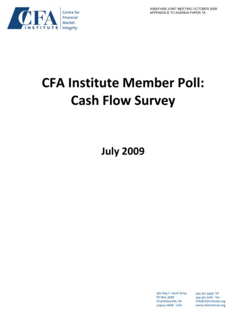
154WILLIAMAND MARYQUARTERLYhimself master, too, of the art of suspense will be agreed, for thepassage quoted engenders quick anxiety to know whether the"unexpected Supply" may have been the kind that walked on fourlegs or only on two.When the party finally reached the head waters of the Potomac, it settled upon a spring close to the summit of the Allegheniesin what is now West Virginia as the official source of the River,more than 200 miles from the mouth of the Shenandoah. It wasdoubtless well into the winter when the last bearings were takenand the gear packed for the long trek home. A voucher for payment of two of the chainbearers, signed by Winslow, Savage andCarter is dated December 29, in all probability soon after thereturn.Winslow as a competent draftsman was doubtless deputizedby his fellow surveyors to make the map and completed it duringthe winter, for its date, 1736, indicates that it was finished priorto March 25, i. e. New Year's Day, 1737.Upon completion of the various field surveys, Mayo was instructed by the Gooch commission to prepare in duplicate a complete map of the Northern Neck by "joining all the particularsurveys together." The result Byrd calls a "masterly performance," and such it undoubtedly was, for when laid before theLords of Trade in England it was found more satisfactory thanthe map on a larger scale prepared by Warner for Lord Fairfax.13It need scarcely be observed that the latter in due course securedrecognition of all his claims, which were finally marked upon theground by the survey of Jefferson and Brooke in 1746.Unfortunately no real end to the point at issue was reachedfor the question of the actual first spring of the Potomac River,on which hinged the destiny of hundreds of square miles of land,has ever since been a bone of contention. So far as state boundaries are concerned, it was finally settled by decision of theSupreme Court of the United States in the case of Maryland vs.West Virginia14 (217 U. S. 1 and 217 U. S. 577, 1910), wherebythe findings of the 1737 survey with regard to the adoption of aparticular spring were ratified.As will be seen by reference to the reproduction herewith,the Winslow plan is quite detailed in respect to the River, itsislands, tributaries and the abutting plantations, some of whichHarrison, op. cit., p. 620.In the first of these decisions is to be found an excellent summaryof the long-standing controversy.See also 174 U. S. 196. The Courtconfirmed the right of Maryland to the bed of the river as far as thelow-water line on the Virginia shore.1314
O-
a -.- -I
I yw
- \--9p- ---itaMc kj9'1!'A4AArt: t1kzJung4esfHeA,
WILLIAMAND MARYQUARTERLY155fail to appear on the general maps. Here set down with some exactness are the former Shawnee settlements near the present Oldtown, Cumberland, and Cresap, in Alleghany County, Maryland,which had been deserted a few years before. Indications of "colemines" at two points adjacent to the River in what is now GarrettCounty, Maryland, between Kitzmiller and Barnum, West Virginia, supply what is believed to be the earliest known evidenceof coal deposits in this region.15 The South Branch of the Riverappears as a smallish affluent, designated as "Wappocomma Riveror the South Branch," in this respect evidencing the belief of thejoint party that the North Branch because of its greater widthwas the main stream.16 The destination of the waters of theYoughiogeny River is accurately stated in a legend at the northwest corner of the map.Considering the time and place, the plan is remarkably competent cartography, and affords evidence of quite accurate surveying performed in the heart of a wilderness amid exposure tonot too friendly savages.17 It was executed, of course, with noother instruments than the theodolite and the surveyor's compass,the method of triangulation not having come into use till near theclose of the century . Nevertheless, to take but one of its striking features, the various meanders of the upper Potomac are foundfaithfully laid down when compared with modern maps. Thelegend like all the names upon the map itself is in script, evidentlythe handwriting of Winslow, for whose pains in setting downmany details that might have been overlooked we are under obligations. It is a matter of regret that biographical information regarding him is scant in the extreme. All we know is that late in1737 he was engaged in surveying and seating, along with others,a 30,000-acre tract west of the Shenandoah, that in 1739 he was15 Statement of Professor Edward B. Mathews of Johns HopkinsUniversity to whom, as well as to Colonel Lawrence Martin, head of theDivision of Maps in the Library of Congress, the writer is under obligation for criticism and suggestions.16 It is worth noting that M'ayo omitted from his map, the only onesubmitted on behalf of the Province of Virginia for decision in England,mention of the South Branch of the Potomac. In setting down the Wappocomma River, he gave no hint that it could be regarded as a branch ofthe Potomac. One surmises that this variation from Winslow's platwas determined by policy. Between Lord Baltimore and Lord Fairfaxthe Virginia commissioners had reasons of long standing not to favor theMaryland side.17This was more than seven years before the Lancaster Treaty withthe Six Nations (1744) under which right of the white man to settleas far west as the forks of the Potomac was recognized.
156WILLIAMAND MARYQUARTERLYappointed sheriff of Essex County18and that when Peter Jeffersonand Major Brooke in 1746 made their survey of the Fairfax "backline," joining the two head springs, he was one of their assistantsurveyors.19Comparison of the Mavo and Warner maps, reproductions ofwhich from the Public Record Office, London, are in the Libraryof Congress and the Virginia Historical Society, with Winslow'smanuscript reveals their failure to include some of the names ofPotomac tributaries and a few names of settlers. In other respectsthe basic surveys were closely followed by the respective makersof the general maps, though in the case of Mayo, on a reducedscale.Age considered, the condition of both new-found plats isexcellent. If we may judge by photostat copies, each is fresherand more legible than the Mayo and Warner manuscripts in London. Save for the action of ink acids where the borders weredrawn in, there is neither hole nor tear in either surface.20Attempts to learn the provenance of the two manuscriptshas proved a fascinating if all but fruitless endeavor. Althoughthe Maryland Academy of Sciences claims 1797 as the year ofits founding, it was at first without formal organization and suffered at least two rebirths, not to speak of a fire in 1835 and theclosing of its gallery and distribution of its possessions within thenext decade. Outliving these misfortunes, it has only recentlyendured another period of stress, with three changes of executivedirector in eight years. It is scarcely to be wondered that recordsare incomplete and its officers uncertain of the origin of some ofits materials. Examining a partial record of gifts, the presentwriter found under date of January 15, 1878, the presentation of a"large library, 162 bound volumes, 210 unbound do. and pamphlets, 90 maps" by Mrs. Ph. T. Tyson. It is not only possible buthighly probable that the last item embraced the two maps withwhich we are concerned. Philip T. Tyson, late president of theAcademy who had died childless only a month earlier, was one ofthe most distinguished scientists of Maryland. He had servedas state agricultural chemist, was the author of papers on mineralogy and allied topics and an associate of John H. Alexanderin early geological surveys of Maryland. In his first report asstate chemist (1860), stressing the need of a geological map of the18 Virginia Magazine, XIV:18 (July, 1906) and XIV:341(Apr.,1907).19 He is one of four surveyors named upon the map.20 The two maps were drawn on identically watermarked paper butthe inks differed as well as the quills used.
WILLIAMAND MARYQUARTERLY157state, he refers to the "want of a correct geographical map. Tosupply this deficiency I have collected all the useful data withinmy reach . . . ." It may be that the valuable plats of Winslowand Brooke were among the materials he gathered. At any rate,search of the Academy's printed records and interviews withpresent and former members of its staff have afforded no betterhypothesis.Also included among the one hundred or so items placed inthe care of the Pratt Library is a considerable group of manuscript maps by Alexander, Maryland's first topographical engineer,who deserves a place in the cartographical hall of fame by reasonof the fact that he was second, if not indeed the first, in Americato adopt contour lines to indicate elevations. His maps, dated1835 or thereabouts, of great beauty and unbelievable fineness ofline, were received by the Academy about twelve years ago. It isknown that no eighteenth century plans were among them. Theclose association of these two men with the upper Potomac isinterestingly emphasized by the fact that they organized in 1837the George's Creek Coal and Iron Company to exploit the resources of the Lonaconing area. Alexander became president andTyson superintendent of the Company. The latter is credited withdiscovery of the great fourteen-foot seam on George's Creek.That there have thus been recovered and made accessible tothe world of scholarship documents representing results of thefirst complete survey of the Potomac is a matter of gratificationbeyond the bounds of the states and the District of Columbiawhich have immediate interest in them. It seems not too much tosay that the survey marked an epoch in geographic investigationof America by the English, for though John Lederer in 16691670, Abraham Wood in 1671, Cadwalader Jones in 1682 andSpotswood in 1716 had penetrated the mountain barrier, no expedition down to this time seems to have accomplished at once soexact and so extended an examination into the interior. At allevents we can be assured that succeeding explorers, includingChristopher Gist and George Washington, profited by the ablework performed in the upper Potomac survey of 1736.
JOHN STEWART BRYAN, E. G. SWEM, President William and Mary Librarian William and College Mary College Vol. 18 SECOND SERIES APRIL, API,13 1938 No. 2 MAPS OF THE FIRST SURVEY OF THE POTOMAC RIVER, 1736-1737 By JAMES W. FOSTER When the Enoch Pratt Free Library of Baltimore a few