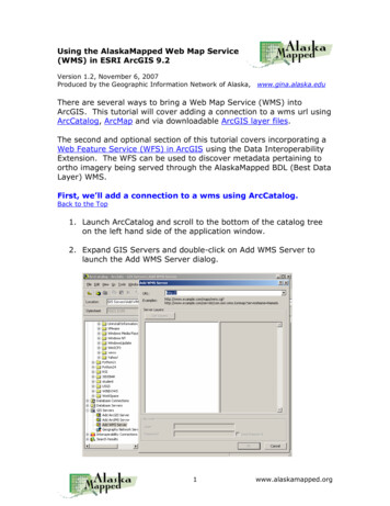
Transcription
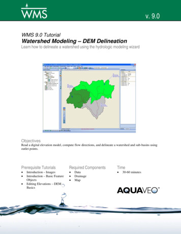
AlaskaMapped Web Map Service (WMS)Tutorial using the UAF GINA SwathViewer Version 1.1, November 7, 2007Produced by the Geographic Information Network of Alaska,www.gina.alaska.eduA quick note before starting this tutorial: Like all Internet MappingApplications, some of the SwathViewer tools will take some timecomplete their process. Excessive mouse clicks before allowing theapplication to resolve previous requests may cause undesireableconsequences.1.Launch your web browser (either Firefox or IE will do).2.Navigate to the SwathViewer Startup Page athttp://sv.gina.alaska.eduNote: if your browser blocks pop-up windows, simply click the link"CLICK TO OPEN IN POPUP WINDOW" to launch the viewer in anew browser window (refer to the startup page example below).Some SwathViewer background:Developed by Dan Stahlke at the University of Alaska Fairbanks,Geographic Information Network of Alaska (GINA), SwathViewerprovides easy access and manipulation of global imagery and mappingdata. Offering imagery in full map context with mouseovers andadvanced querying capability, this lightweight Java applet (1.2MB)enables users to rapidly zoom, pan and layer multiple images andmapping data together without installing additional software.1www.alaskamapped.org
3.SwathViewer will launch displaying the NASA Blue Marble satellitemosaic centered on Alaska.4.to clickUse the ZoomIn tooland drag a zoom box aroundjust the state of Alaska.2www.alaskamapped.org
Rather than using the Zoom In tool to repeatedly zoom in untilyou are centered on the city of Fairbanks, simply click the Seek toTarget buttonand choose Fairbanks from the list of locationoptions. The result of performing this task is shown below.Note that you can also perform this task by entering a centerpoint Longitude and Latitude in DMS into the upper left corner ofthe interface, then dragging the slider bar to the desired pixelspatial resolution.Notice that as scale becomes larger, higher resolution datasetsare displayed (a LandSat-7 mosaic should be currently displayedat around a scale of 1:200,000). The next few steps will walkthrough the process of adding external geospatial data, thealaskamapped.org web map services in this case, to theSwathViewer interface.3www.alaskamapped.org
5.Click the Configuration toolandchoose the Import WMS option fromthe drop-down list of options. Typethe URL to the AlaskaMapped BestData Layer (BDL) in the text box onthe WMS Import dialog, then clickOpen to load the bdl wms into theSwathViewer TOC, as is shown in theexample below.Click Open to add the BDL WMS to your SwathViewer session.Some background about the BDL WMS:The BDL (Best Data Layer) is the repository for the Alaska StatewideDigital Mapping Initiative (SDMI). More information about SDMI canbe found at http://www.alaskamapped.org. The goal of this WMS is toprovide open access to the most current publicly availableortho-rectified imagery across the entire state of Alaska. WMS is anopen source protocol defined by the Open Geospatial Consortium(OGC, http://www.opengeospatial.org) and can be implemented in avariety of mapping software platforms.6.Click on the toggle switch icon to the left of the bdl high resentry, then highlight the High Resolution Natural Color (0.25-9m)(Detailed) listing in the TOC. A check-box that controls thevisibility of the highlighted layer will be made available in thewindow directly under the TOC. You may have to use thehorizontal scroll bar or click and drag the TOC window to the rightin order to be able to read the full layer name.4www.alaskamapped.org
7.Check the boxto turn on thevisibility of theselected layer.When thedisplayrefreshes, youwill be viewinga mosaic ofDigitalGlobeQuickBirdsatelliteimagescourtesy ofthe FaribanksDNR Divisionof Forestry.8.Enter the following coordinates in the upper left hand cornernavigation control of the interface 147 48'52"W, 64 50'16"N, thenclick the Go button. After the display completes its refresh, clickand drag the spatial resolution slider to 1m then release.Coordinates can also be entered as 147.48.52W 64.50.16N or147d48m52W 64d50m16N.5www.alaskamapped.org
The display will refresh at a scale of 1:3,900 centered on the AKDNR Forestry Building across Airport Way opposite the old FredMeyers building in Fairbanks, AK.and navigate to directory of9. If you click the Save State buttonyour choice, name the .sv file and click Save, the next time youuse SwathViewer, you may load the state file (*.sv) and return tothis same view, provided you still have access to the data used inyour SwathViewer session.Parting Thoughts:If you haven't done so, it is worth taking a moment to scrollthrough the list of available data already available in SwathViewerusing the table of contents on the far right side of the display.You can incorporate your vector data into SwathViewer using theKML/GPX tool (this includes the shapefile format as well). Pleasekeep in mind that any vector data added to the SwathViewer mustbe correctly referenced to Geographic Coordinates in WGS84 to bedisplayed correctly.Currently, there are three additional WMS available throughAlaskaMapped; one named Extras containing a variety of rasterdatasets that are in frequent demand among end-users ofgeospatial information (i.e. USGS Digital Raster Graphics, USGSNational Elevation Dataset Shaded Relief, etc ), and twocontaining the full listing of NOAA Nautical Charts for the State ofAlaska (not suitable for navigation; charts contains each chart asa layer and each layer has been processed to crop the map collarwhile layers in charts nc have not been cropped) named Chartsand Charts nc. These are at the following URLs:Extras: http://wms.alaskamapped.org/extrasCharts: http://wms.alaskamapped.org/charts andhttp://wms.alaskamapped.org/charts nc (nc not cropped)Each of these WMS can be added to SwathViewer using themethod presented in this tutorial. Please contact GINA with anyquestions or comments you may have via email atwms@alaskamapped.orgAuthor: Peter J. Hickman6www.alaskamapped.org
AlaskaMapped Web Map Service (WMS) Tutorial using the UAF GINA SwathViewer Version 1.1, November 7, 2007 Produced by the Geographic Information Network of Alaska, www.gina.alaska.edu A quick note before starting this tutorial: Like all Internet Mapping Applications, some of the SwathViewer tools will take some time complete their process.