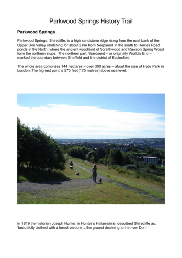
Transcription
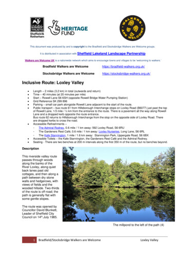
This document was produced by and is copyright to the Bradfield and Stocksbridge Walkers are Welcome groups.It is distributed in association with SheffieldLakeland Landscape PartnershipWalkers are Welcome UK is a nationwide network which aims to encourage towns and villages to be ‘welcoming to walkers.’Bradfield Walkers are ge Walkers are ve Route: Loxley Valley Length – 2 miles (3.2 km) in total (outwards and return)Time – 40 minutes (at 20 minutes per mile)Start – Rowell Lane S6 6SH (opposite Rowell Bridge Water Pumping Station)Grid Reference SK 299 896Parking – small car park alongside Rowell Lane adjacent to the start of the route.Public transport – bus route 61 from Hillsborough Interchange stops on Loxley Road (B6077) just past the topof Rowell Lane, 1/3 mile / ½ km from the entrance to the route. There is a pavement all the way along RowellLane and a dropped kerb opposite the route entrance.Bus route 62 returns to Hillsborough Interchange from the stop on the opposite side of Loxley Road. Thereare dropped kerbs to cross the road.Accessible Refreshments –- The Admiral Rodney, 0.6 mile / 1 km away: 592 Loxley Road, S6 6RU- The Gardeners Rest Café, 0.6 mile / 1 km away: Loxley Nurseries, Long Lane, S6 6RL- The Kafe Stannington, 1 mile / 1.6 km away: Stannington Park, Uppergate Road, S6 6BXAccessible Toilets – the Kafe Stannington, the Gardeners Rest Café and the Admiral Rodney.Seating - There are two benches at 200 m intervals along the first 350 m of the route, but no benches beyond.DescriptionThis riverside valley routepasses through woodsalong the banks of theRiver Loxley, along quietback lanes past oldcottages, and then along apath between dry stonewalls and hedgerows, withviews of fields and thewooded hillside. Two-thirdsof the route is off-road; thepath is generally flat withsome gentle slopes.The route was opened byCouncillor David Blunkett,Leader of Sheffield CityCouncil on 14th.July 1985.The millpond to the left of the path (4)1Bradfield/Stocksbridge Walkers are WelcomeLoxley Valley
Access Information1Road/off road: Parking is in a small car park alongside RowellLane. There is approximately 2.20 m to unload a wheelchair fromthe back of a medium-sized wheelchair accessible vehicle (1), so itis advisable to look out for cars and wear a hi-visibility jacket whenunloading.The first and last third of the route are off-road; the middle sectionand the last 250 m are on quiet no-through-roads.Surface: The surface of the paths is compacted gravel and issuitable for wheelchairs. After rain there are some shallow puddlesand mud (2). There is no tactile paving at the entrance/exit and theground there is slightly uneven.2Width of path: The entrance/exit is 93 cm wide at the widest partand can easily accommodate wheelchairs. The path is between2.70 m and 1.30 m wide, with a narrow stretch 75 cm wide.Camber: The path is mostly flat with an occasional slight camber.Gradients: The path is mainly flat with some slight undulations.Along the first 350 m, there is a gradient of approximately 1:12, for30 m uphill and 30 m downhill.Rails / edges: For the first 450 m, there is a tapping rail along theopposite side of the path from the river (3). In a few places there is agap of approximately 1.5 m in the tapping rail. In several places,foliage has grown over the tapping rail.3The bridge, approximately 300 m from the start, has metal handrailsand there is a gap 120 cm wide between the handrail and where thetapping rail starts again on the path (4).The tapping rail ends after the path makes a left turn, just where itmeets Black Lane.4At this point, on the side opposite the tapping rail there is a gap inthe wall where steep stone steps lead down from the path (5).After the tapping rail ends, there is a driveway on the left, while thepath opens out on the right into Black Lane.On each side of Black Lane there are stone walls.Cars are parked in front of the houses at the end of Black Lane andopposite the houses on Low Matlock Lane.5Apart from these sections by the houses, and one short stretch onthe river side of the path, where there is a wooden fence, the edgesof the route are either foliage or stone walls.Along the first 450 m, there are occasional breaks in the foliage onthe river side of the path and the ground slopes down from the edgeof the path.There are no painted edges at the side of the path.2Bradfield/Stocksbridge Walkers are WelcomeLoxley Valley
Obstacles: There is an uneven surface approximately 200 m fromthe start, halfway up a short gradient where a drainpipe is buriedunder the path (6).6Halfway along the narrow section of the path, 450 m from the start,there is a 5 cm high uneven tree root across the path (7). It ispossible to go around it as there is a concrete surface adjacent.Foliage has grown over several sections of the tapping rail.At the end of the riverside section of the route, just before the pathmakes a left turn, foliage juts out into the path (8).7Apart from this, at the time of writing there were no obviousoverhanging branches.Just before the path meets Black Lane, the compacted gravelsurface gives way to concrete and the surface is uneven (9).There are no stiles or narrow plank bridges.891Route Instructions1. Go through the entrance to the route on the lefthand side of the car park. The entrance is 93 cmwide at the widest part and will comfortablyaccommodate a wheelchair.2. The route continues along the River Loxley.3. After approximately 300 m you come to a bridge(3). Continue over the bridge and along the path tothe left.34. Pass the millpond on your left.5. After 450 m, the path narrows and passes a stonehouse on the left (5).3Bradfield/Stocksbridge Walkers are WelcomeLoxley Valley
6. Just after the house, the path turns sharply to the left,continues between two stone walls (6) and comes outonto a broad flat lane (Black Lane).57. Continue along Black Lane, passing a row ofcottages on your right.8. After passing the cottages, bear round to the left,then turn right onto Low Matlock Lane (8).9. After approximately 100 m, pass through a gate:there is an accessible gap to the side of the gate, 140cm wide (9). Continue past some houses.10. After passing the houses, go through a gateway (10)onto the continuation of Low Matlock Lane, which atthis point becomes an unmetalled public footpath.611. After approximately 550 m, the path joins a metalledlane.12. Continue along the lane for approximately 100 m untilyou reach a junction, with a driveway to your right, alane to your left, and a footpath straight aheadleading into the woods.13. The lane to the left is a public right of way. It leads upto Loxley Road, after approximately 150 m. There areaccessible bus stops close by on Loxley Road. Thegradient of the lane is approximately 1:10 and thesurface is rough and patched.814. The inclusive route ends either at the junction, or ifyou wish, at the top of this lane, back on LoxleyRoad.9104Bradfield/Stocksbridge Walkers are WelcomeLoxley Valley
Historical Notes and Points of InterestThe River Loxley is one of five rivers which were the birthplace of Sheffield industry. The Loxley rises inthe peat moorlands of the Peak District and flows for six miles before entering the River Don.Now a rural backwater, the Loxley Valley was once a centre of iron and steel production, using the fastflowing river as a source of power. The wooded hillside to the south hides the remains of stone quarries.There had been corn mills and cutlers’ grinding wheels along the Loxley since Medieval times, but the mainperiod of industrial development was in the 18th.Century. In the 19th.Century, forges and rolling mills beganto replace, or were built alongside, the cutlers’ wheels. A total of 24 mills, wheels, and forges are known tohave existed along the Loxley. Construction of the dams was a major undertaking. Weirs were built toraise the level of the river and water diverted into a head goit into dams. These fed pentroughs whichgoverned water flow to the wheel before its discharge to a tail goit, either to another wheel or back into theriver.Many of these operations were destroyed or damaged when Dale Dyke dam burst in March 1864.Seventeen lives were lost in Loxley, including five members of the Chapman family, their servant AlatheaHague, and apprentice John Bower. The rolling mill owned by the Chapmans was completely destroyed.Some of the victims of the flood were buried at Loxley Chapel.In the 19th.Century, Loxley became an important producer of refractory bricks, used to line furnaces in theexpanding Sheffield steel industry. Ganister was mined in the area to supply firms such as Thomas Wragg,Hepworth, and Marshalls. Production ended in the 1990s. Industrial decline in the Loxley Valley has led toit becoming a haven for wildlife.Loxley Chase was once a large expanse of open moor and woodland, used for hunting after the Normanconquest. In the 12th.Century it extended as far south as Nottinghamshire, where it joined SherwoodForest, leading some to claim that it was the birthplace of Robin Hood, supposedly at Little Haggas Croft,in the area of Normandale House.Loxley United Reformed Church is a grade 2* listed building near the junction of Loxley Road and RowellLane which was built in 1787. It closed as a chapel in 1993 and is now in private ownership, although thecemetery is still in use.Loxley House is a grade 2 listed grand Georgian house on Ben Lane. It was built in 1795 by ThomasHalliday, who also built the Robin Hood Inn at Little Matlock. The house was completely rebuilt in 1826 byThomas Payne. It is said that the last member of the Payne family was buried in the grounds in anunmarked grave, as he had had an argument with the vicar of Wadsley and vowed never to go to churchagain. Both the house and the Robin Hood are now private apartments.For more information about the area, see:Ball,C., D Crossley,D., and Flavell,N. (eds.) (2006) Water Power on the Sheffield Rivers, South YorkshireIndustrial Society.Battye,R. (2004) The Forgotten Mines of Sheffield Especially Around the Upper Don, Loxley, and SheafValleys, ALD Print and DesignNun,M. (1996) Around Bradfield, Loxley, and Hillsborough, Tempus Publishing Ltd5Bradfield/Stocksbridge Walkers are WelcomeLoxley Valley
dge-walkers.org.uk/Please utilise the ‘contact’ link on our websites if you wish to suggest any amendments to these instructionsExcept where expressly stated to the contrary, copyright in the text, graphics and information contained in this web site (including downloads) isowned by Bradfield and Stocksbridge Walkers are Welcome. You may print, or download to a personal computer, extracts for personal use.Permanent copying and/or storage of whole or part of this web site or the information contained therein or reproduction or incorporation of any part ofit in any other work or publication whether paper or electronic media or any other form is expressly prohibited unless agreed otherwise.Material available from our websites, including downloadable .pdf files, is provided for information purposes only. Whilst every care is taken incompiling information we do not make any warranties or representations as to its accuracy or reliability. We may make changes to this material at anytime without notice. Certain information on the websites may contain typographical or other errors or be out of date, and we make no commitment toupdate such information. We and any third parties referred to on the websites assume no responsibility for how you use the information providedthrough the websites.This leaflet was created with thanks toNational Lottery players and the Heritage FundLayout: Dave Pickersgill & Katherine WedellText: Katherine Wedell & Isaac WhitePhotos: Dave Pickersgill & Katherine WedellEdited by: Dave Pickersgill OpenStreetMap contributors6Bradfield/Stocksbridge Walkers are WelcomeLoxley Valley
In the 19th.Century, Loxley became an important producer of refractory bricks, used to line furnaces in the expanding Sheffield steel industry. Ganister was mined in the area to supply firms such as Thomas Wragg, Hepworth, and Marshalls. Production ended in the 1990s. Industrial decline in the Loxley Valley has led to it becoming a haven for .